
High Sierra
Backpacking
Trail Guide
Forums
Sierra
Weather
WeatherNotes Northern
Sierra Weather
Gear
The Tahoe to Yosemite Trail
Backpacking or Day Hiking to
Lake Genevieve out of Meeks Bay
Desolation Wilderness
Languages
Trail Skills
Mountain
Safety
Food
Planning
Trail Arts
More
Information
Social
| Trail guide INDEX |
North |
South TYT Crag Lake |
Meeks Bay TOPO MAP |
MILES Meeks Bay to Echo Lakes |
Miles and Elevations INDEX |
Lake Tahoe Basin Management Unit |
All Permits |
All |
Video
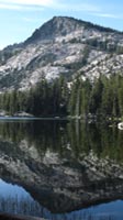
Lake Genevieve, Desolation Wilderness
morning
| Lake Genevieve | ||
Video
|
The Value of Reflective Water There are sometimes unique moments of early morning stillness
in the mountains. Stillness Ensues. The beauty surrounding us rapidly multiplies itself during these fleeting seconds when air and water become momentarily balanced. Critical Mass is attained when this external beauty Through the Looking Glass Other times the lightest of breezes drive shimmering waves reflecting a chaotic world of sparkling lights dancing on the lake's surface, sometimes shimmering whirlwinds. Both states are nice. These fantastic external beauties are multiplied and grow as they pass our mind's eye to resonate with and feed the soul. These beauties act as a trigger, tapping into deep internal reservoirs of experiences, skills, resources, and feelings that nature equipped us with, but only come out when called back to natural engagement. "They" say that "humans only use 10% of their brains." I say that humans have lost 99% of their physical and spiritual assets, have forgotten that engagement with nature is not just the key to the meaning of life, but to a meaningful life as well. Reflecting lakes are the sparkle in Nature's eyes, and eyes are portals to the soul. Beautiful reflective lakes act as a spiritual/psychological key for humans. The psychological effect of this great beauty justifies the hard work required to view it. Nature has other uses for our lost observation and engagement skills. But it first has to break them loose from their social captivity. The stillness of reflective lakes are portals linking the spirit of Nature to the souls of men. These are the times and situations that draw out and reward our engagement. The work required to engage nature and its beauties does not just deepen the beauty, but becomes a vital part of the beauty itself. The Journey Begins This new feeling is the knowledge that the deep joy of engagement with Nature does not just open up and draw out hidden skills and potentials within ourselves that are normally locked down by the spiritual wasteland of urban life, but that natural interaction introduces alternative definitions of the nature and the meaning of life than the passive consumer gratifications popular today. We've only just begun to scratch the surface. Let the backpacking begin! We're falling into the real looking glass now... |
Sunrise above Lake Genevieve
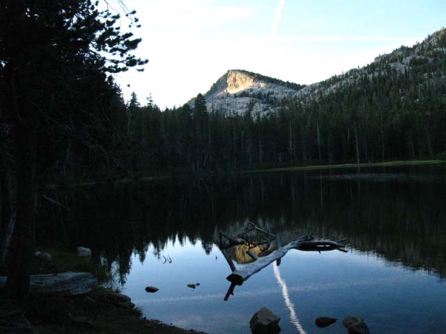 |
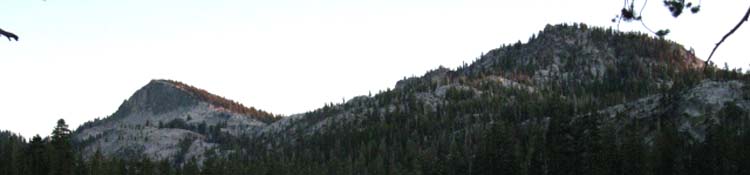
First light striking face of Peak 9054 behind Lake Genevieve. Besides avoiding the crowds of Summer, Fall travelers experience the higher contrasts brought out by the lower angle of the Sun on the mountains. The increase in contrast and the associated decrease in glare opens up rich fields of view obscured during the High Summer. A subtlety unseen in the brighter light of Summer emerges in Fall. Time to Hike! |
Sunrise on Granite
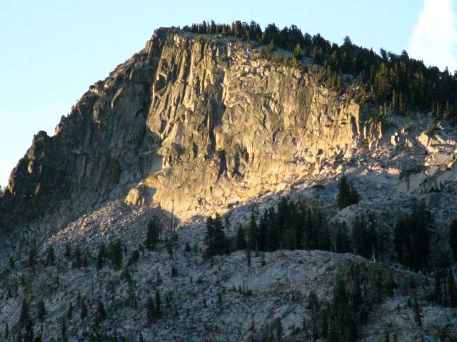 |
Detail of first light striking face of Peak 9054. Peak 9054 is the Northwest pair of the two peaks capping the head of this valley. |
Chain of Lakes Lake Genevieve is the first in a series of five lakes we encounter entering the mouth of this gently rising valley. We pass these lakes while hiking within the two and a quarter mile length of this gentle rising valley. Enjoy it now. Genevieve, Crag, Hidden, Shadow, and Stony Ridge are the series of lakes we will encounter. Let's take a look at them on the map and miles pages:
These lakes give us lots of camping options along the length of this valley fitting between the fourth and sixth miles of our hike South out of Meeks Bay. Rubicon Lake is not one of our options along this little chain of lakes. Rubicon Lake is nestled into rocky folds buried under dense forest above the head of this valley, about 400 feet higher and a mile further South past the South Shore of Stony Ridge Lake, which is the last lake in this little series of valley lakes. Note Stony Ridge lake's position on the map. The narrow strip of flat terrain the TYT runs through between Stony Ridge Lake's NE shoreline and the rising terrain is too narrow for legal camps, though there are campsites halfway down the length of the lake. The terrain off the South Shore of Stony Ridge Lake is too marshy for good camping. Shadow and Hidden Lakes have nice aprons for camping around parts of their shorelines. It is nice here, in this sweet little valley. A Doubly Protected Space Not only is this a wilderness area that is preserved against development, but it also must be afforded higher protections against the fundamental overuse by our much too large population. I don't like quotas, but they have only become necessary because we cannot control our growth. Thus we are forced to protect nature once, then again. Kidriffic This is a good place for rookie backpackers of all ages! First, the distances and elevation increase out of Meeks Bay to this chain of lakes are not too bad for parents splitting a kid's gear, nor too difficult for many growing kid hikers. Second, the terrain is stunningly beautiful, and subsequent trips can be extended deeper into the Desolation Wilderness over the years as the kids grow and their capacities increase. Rookie adults will appreciate this expandability as well. Third, this valley is full of fun things to explore at our leisure. Once we hike in and camp there are plenty of activities to keep the kids of all ages engaged in a lifetime of rewarding experiences. |
Desolation WildernessMeeks Bay to Lake GenevieveJust the Facts, ma'am Lake Genevieve Elevation Mileage 4.49 miles |
Camping Notes Sunrise Temp before Sunrise Camp Status Overall Weather Time, Space, Direction, and You This handy information allows us to use the Sun as a compass and a clock. We now know both the exact time and precise compass points at sunrise, sunset, and the "city time" of when the Sun crosses the North-South line, AKA, High Noon. FACT: It is Noon when the Sun crosses the North-South line in the sky from our position, NO MATTER WHAT your watch says. One is "city time," the other is your own personal "astronomical time." Yes my dear, all time and space does rotate around you. The last bit of astronomical information I am bringing is either The backpacking links page has a wide selection of different types of nature, instructional, and trail guides, maps for use on the trail, and even a selection of free utilities and technical resources helpful for backpackers. We'll use this information to ascertain the Sun rise and set compass points and timing on the horizon without using a compass, and know the "civil" time when the Sun crosses the celestial meridian. We will literally and accurately measure the distance of the Sun's daily travel across the sky to both estimate and precisely determine both "city" and "astronomical" time, as necessary for our situation. Our planet spinning around our Solar System is literally our But unlike most watches, I'd argue that ours is actually wearing us, Who's in who's pocket? Is each of us no more than a little "second hand," running around and around on the face of the master clock of life? The "times" mentioned above, being the Sunrise and set times when I take my daily temperature measurements reflects the time of Sunrise and set during late September, which was the start day of a particular trip. This brings up two important facts. First, the time and location of Sunrise and set are in constant motion over the course of a year,
even if we retain a fixed position. I have brought together a number of astronomical tools and information resources that describe and explain the rhythms of celestial and terrestrial motion and how this relates to navigation, and us keeping our bearings.
Everything is Moving That's why the astronomical data we need is derived by entering a location as well as a date in the database. Exactly where and when the Sun rises and sets is dependent on our location and the date. Short Backpacking Trips A Regular Rate of Change We can figure it out by noting the change in timing and location of Sunrise and set from a single position over the duration of our trip. This rate of change will be a reliably consistent correction factor to reasonably correct our Sunrise and set figures. Long Backpacking Trips The Tahoe to Whitney This information will not just keep us "in time," but also establishes a fundamental context structuring the terrain we cross by keeping us aware of and engaged with the physical relationships between time, space and terrain. Time, direction, terrain and our position within it are different, changing, and related aspects of dealing with these grand mountains who's crestline we are hiking. We're going to keep our bearings and time squared-away as we hike South. Our ability to organize and correlate time and space information adds extra dimensions to our engagement and understanding of the logical and physical relationships holding the the High Sierra together. |
North: Lake Genevieve 1 South: Crag Lake
Morning One |
|||||
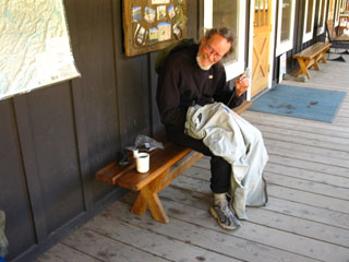
The temp was 43 degrees at Lake Genevieve when I woke and rose well before dawn. Granola, powdered milk, and dried fruit were rapidly brought to life with a little heat under the roar of my old-school MSR white gas stove, and I was shortly fed, packed, and ready to saddle-up. Time to take off the insulation and freeze a bit before the pack and the trail warm me up. I tried to unzip my REI fleece jacket, and everything went to shit. The zipper is one of those fancy "clasping" zippers, the type that lock. The fabric pull and its ring broke off the zipper, locking the clasping zipper in place. With no pull strap there was no way to unzip the fleece jacket, and claustrophobia set in, and I was soon bouncing/hopping about in circles trying to get the damn thing unzipped from high around my neck. Finally, I used the flat end of the can-opener on my Swiss Army Knife to pry up the edge of the spring-loaded locking clasp on the back of the zipper assembly, and was finally able to unzip my fleece jacket in fits and starts. I was tempted to use the knife's blade to cut the coat off. Relax Al, Chillaxation required... take a couple of deep breaths. I promptly removed the locking mechanism from the zipper, (a zipper-ectomy) and everything was all cool again. The jacket still zipped-up, but I had to grasp the zipper on both sides to make it work, as the pull tab had broken off. But my gear was falling apart. This was not unexpected. I had already put 750 long-distance backpacking miles on the gear this Spring and Summer (2009), and my gear was showing it. My boots, pants, and socks were all starting to wear thin. The harness of my pack was worn, and all grommets were distorting. I was monitoring the degradation of all key gear components. I was packing a bigger spare parts kit than normal. I am facing a maintenance cycle with my clothing, pack, boots, and most of the gear elements that wear out. Clone me a new frk'n body too, while we are at it... I'm going to re-harness my pack frame, replace or repair my worn-out clothing, and new boots have been necessary for awhile. Where are you in the "Gear Cycle?" Keep tabs on how your gear is wearing, and check your harnesses, stitching, clasps, and eyelets often during your long trips, and an inspection before every trip. Inspect the stove and water filtration device, and clean each as necessary. Broken and fixed Be Ready! Check out the Gear Section |
|||||
 |
A frk'n gopher ran a hole up to the surface under my backpack, which was laid flat on the ground with rocks on top to protect its salted straps from just such a varmint attack... Sometimes we just can't win... |
||||
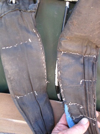
Wilderness gear Repair at Kennedy Meadows Pack Station, earlier in the 2009 backpacking season. Pants in hand, fleece pants deployed during the day! I love They loaned me the needle, and gave me the thread to keep my ass in my pants, and my straps on my shoulders. The cowboys offered me the use of their saddle shop, but I didn't need to go nuclear!
|
|||||
Topo Map South South Desolation Wilderness
South |
|||||
Hiking North |
 |
Hiking South |
Backpacker Forums Post it on Welcome to Tahoe to Whitney
Anyone can post text comments in the existing forums, but only members can post up new topics, along with images, maps, and formatting. As we addressed some gear issues on the page above,
If you have experiences, comments, questions, trip reports, trail conditions updates or pictures and/or videos of the Tahoe to Yosemite Trail from Meeks Bay to Lake Genevieve, and camping around Lake Genevieve and up the valley, post up your images, experiences, notes, and advice here as an unknown hiker or as a member: Section
|
North: Lake Genevieve 1 South: Crag Lake
Trailhead
Contact
Alex Wierbinski

Backpacking Lake Tahoe to Mount Whitney
Your guide to the High Sierra Crest, including the Tahoe to Yosemite, Pacific Crest, and John Muir Trails
