

The Trails
Guide
Maps
Miles/Ele
Permits
Resupply
Forum
Weather Conditions
Weather Notes
Northern High Sierras
Central High Sierras
Southern High Sierras
Gear
Gear List
Gear Forum
Gettin Started
Layering
Testing yourself and your gear
Gear Reviews
Backpacking to Fontanillis Lake
Tahoe to Yosemite Trail
Campsite #2
Hiking the Tahoe to Yosemite and Pacific Crest Trail through Desolation Wilderness
Translate
Languages
Trail Prep
The art of walking
Physical Preperation
Planning
Trail Skills
The trail
Off the trail
Scrambling
Maps
Navigation
Camp skills
Food
Resupply
Food
Other
Photo Catagories
Trail Stories
Trail Culture
News and Science
Links
Groups
Books
Terms and Conditions of Use
Hiking from the North to South
shores of
Fontanillis Lake
to my
Second
Tahoe to Yosemite Trail
Campsite
| Fontanillis Lake II: South Shore |
|||
Desolation WildernessMeeks Bay
|
| Phipps Pass to Heather Lake 15 minute topographic backpacking MAP |
South Desolation Wilderness 30 minute backpacking MAP |
Meeks Bay to Echo Summit
Backpacking Miles and Elevations
|
The two trails Southwest from Eagle Falls and Bayview join together then split apart approaching the TYT-PCT. It's 3.89 miles from Middle Velma Lake to either Eagle Falls or the Bayview Campsite Trailheads. It's 3.68 miles from the trail junction South of Fontanillis Lake to either Eagle Falls or the Bayview Campsite Trailheads. It's 2.49 miles from Middle Velma Lake to the trail junction South of Fontanillis Lake. North Desolation Wilderness Backpacking Hiking in through Meeks Bay Trailhead and hiking South to Fontanillis Lake and out through either Eagle Falls or Bayview Camp is |
Middle Velma-Fontanillis Lake Backpacking Loops
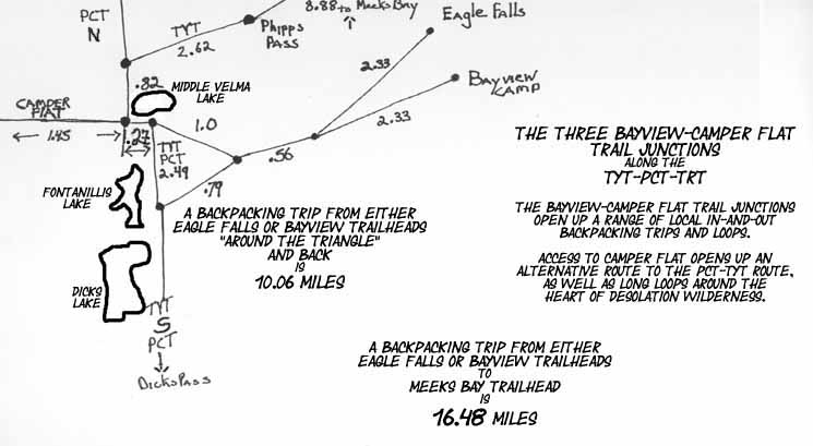 |
We've got access to Middle Velma and Fontanills Lakes from the Eagle Falls and Bayview Camp Trailheads off Highway 89 along the West Shore of Lake Tahoe. Phipps Pass to Heather Lake We can expand trips centered on Middle Velma Lake by hiking North up to Meeks Bay Trailhead or South to over Mount Tallac or Glen Alpine. |
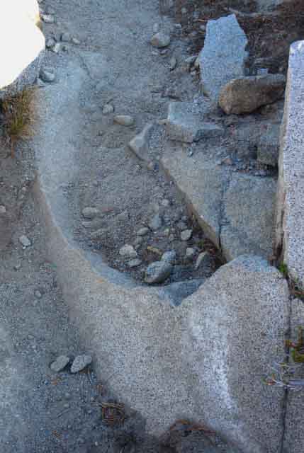
Exceptional Exfoliation
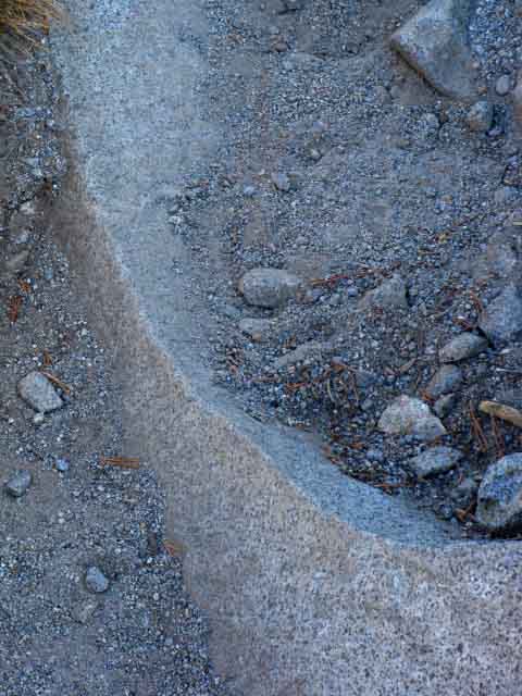 |
Exceptional Exfoliation Detail. Full picture below. The original huge exfoliation happened long enough ago to be almost filled in and covered by soil from countless rain and runoff cycles. |
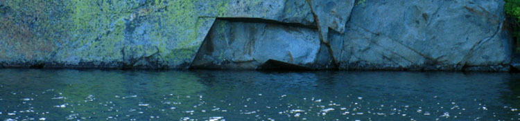
Considering the Beauty of Fontanillis Lake in the Valley below Dicks Pass
Hiking with AlThe exfoliation feature above highlights the fact that terrain is in motion. Some terrains move slowly, others rapidly, but everything is in motion. Forever in a Glance Much of this motion is discernable over a few seasons. Other times we only see the "result," seeing only a thin slice of time and perspective of a scene changing through eons of gradual movement, such as the slow processes happening to the rock fragment above. Subtle yet inextricable forces are slowing moving and sculpting the great mountain ranges surrounding us at Fontanillis Lake. Around this shard of exfoliation above I can picture countless seasons of cooling, heating, internal stresses and external shifts in pressure first cracking this graceful arc off its mother rock, then tens of thousands of Fall rains and Spring runoffs carrying layer after layer of sand and rocks down slope to deposit sands representing almost unseen forces slowly leveraging this exfoliating formation further and further from its mother rock until it exists as a independent piece of living art partially submerged and still moving in currents of sand and soil for our momentary viewing pleasure. A sweet slice in time, baby! The theories about why this happens are as varied as the beauty exfoliation creates. The semi-submerging of this granite fragment in eroded tailings happened as it peeled off from its mother rock during its transition from a granite block into a granite boulder. We can see that the same exfoliation process that cracked the forms of the great domes rising out of Yosemite Valley is also working on the micro-scale carving granite slabs and boulders up and down the Sierra Crest. Seasonal Timer Great Engines of Life The migration and breeding patterns of land animals, the insect kingdom, and the birds are all timed to exploit the Spring Bloom's bounty. Life on land, sea, and in the air are all tied and interlinked to each other and our behaviors timed to depend on these great seasonal Engines of Life. The character and progression of our seasons is not just limited to timing the rise of life in Spring and its recession in Fall. Hitting the Brakes The progression of the seasons determines the rate of change of the physical terrain itself as well as the timing and feeding of the biological cycle of life nestled within the physical terrain. Living things can alter the terrain as much as erosion in some locations. The changed character and timing of the seasons have already altered the pace and timing of the Spring Bloom as well as the "timing" of erosion of the physical terrain and how living things interact with the terrain in the High Sierra. The character and timing of the seasons continues to change rapidly. The lengthening of Summertime, Fall stretching into short, abrupt Winters has disrupted the Engines of Life over water, land, and along the High Sierra. It appears that the rate of changes in the character and timing of the seasons is actually accelerating. Summer is getting yet hotter and drier. Fall is becoming the "new" Winter, and Spring is beginning and ending earlier each year. These changes have slowed the forces of erosion. The diminishment of the Spring Bloom has lessened the power of life in the Sierra, and the diminishing water supply has slowed the growth and movement of the forests. The forces of water and forest cracking Hich Sierra granite have radically diminished over the past 40 years. Forever in a Passing Second My joy in observing this exfoliation feature and the long processes surrounding it are enhanced by my physical stress, while my perception goes beyond the alluring beauty of its shape itself and is expanded by enjoying the processes that controlled and created its beauty over time, and that of the surrounding valley, all of which become visible during this very brief instant we pass through it. This shit is special. Take the time to consider it carefully, as well as withstand it physically. Take all the time you need to see forever in every second you observe carefully. New framework of perception Adjusting the body and mind over many days of hard travel through stunning natural terrain tunes the senses to nature, if you allow it to, which contributes to breaking-readjusting-our mental perceptions, definitions, and assumptions of what actually constitutes pain and pleasure. The natural environment will change the fundamental way we think and feel, if we let it. Different folks go through this at different rates of adaptation. Replacing the social environment with Nature is the first step. Elimination of social chatter and social assumptions is a second step. Dissolve Social Assumptions This "breaking-readjusting" our perceptions and definitions from social to natural is potentially a harsh process. But not necessarily so. Planning and preparation is the Key. Hardening your body a bit with some pre-trip training and even a short "practice" backpacking trip or two can clear away or solve many of the little problems that will drive us crazy on a long trip. Blisters, ass rash, and gear issues are best worked out on short trips. Planning the first days of our backpacking trip with gradually increasing workloads over time can be essential for laying the foundation for successful long distance travel. Independent of how well trained we are, there will be an adjustment phase transitioning between city sidewalk and High Sierra trails. I call this the "transition" period. I have also referred to this process as "the scraper." Long term high mileage emersion in Nature, especially the harsh beauties of the Sierra Nevada, scrapes away social distortions. After the trail and us get together to redefine our perceptions, retune our metabolism, and re-set our concepts of time and space, we are properly tuned to accurately perceive and move effectively through the natural environment. Put on your seatbelt! My point of transition is generally three to five days down the trail, from wherever I start. The transition from social noise to natural noise creates what I call "roar of silence, " when the gaping void of urban background noise makes the lack of noise roar. Ticket Please The beauty of nature has a brutal backside in its high admission price. Every step can be hard work. The pack can pain the shoulders, the rocks can batter the feet. Every obstacle can weaken you. Each obstacle must be overcome while laying your own foundation for long term safety in strength, endurance, perception, engagement and growth. The end of this process is the beginning. Now that you are achieving access to nature and your inner potential it again comes down to the same question: What to do with it. How you answer this final ongoing question defines your character. It is like dotting the "i" or crossing the "T." First you gotta get there, then you gotta do it. I say "enjoy the hike, the natural environment, your fellow hikers, and yourself." |
Details of Trail and Terrain
between
North and South Shores
of
Fontanillis Lake
 |
 |
| Delightful Trail Feature: Full Exfoliation. | North Shore of Fontanillis Lake looking South. Shadow over trail along Eastern shore of Fontanillis Lake. Shadow descending over the Southeastern side of the Crystal Range beyond. |
| top of page | |
Exceptional Views
of
Lake Tahoe
reward us for our brief hike
South
up from
Fontanillis Lake's Northern Apron
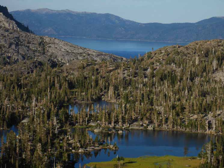 |
Climbing South from Fontanillis Lake's Northern shore brings us to a unique view East-Northeast between the two rock prominences on the Northeast side of Fontanillis Lake. From here we a glimpse of Lake Tahoe's Eastern shoreline over in Nevada across the lake, backed-up up by the Carson Range. Lower Velma Lake sits in the foreground above. Carson City lays in the Carson Valley on the other side of the Carson Range. |
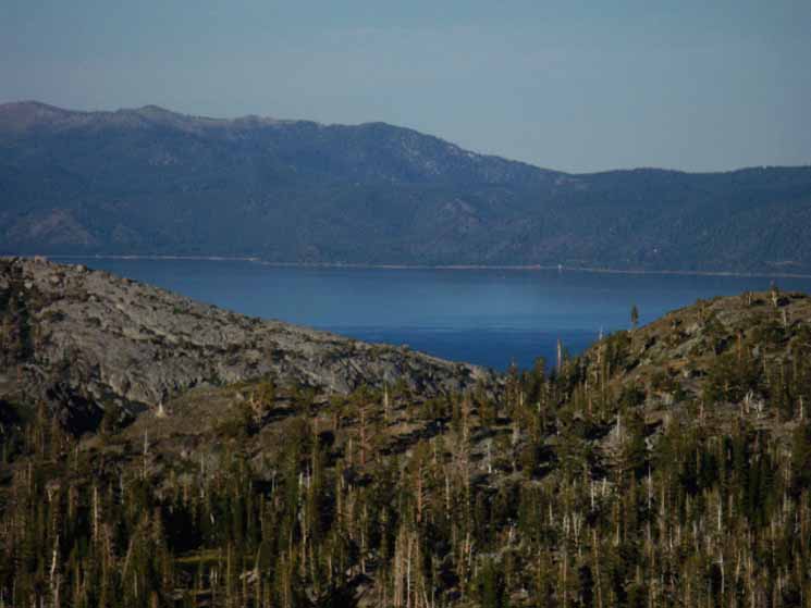 |
The same view of the Carson Range on the East side of Lake Tahoe as above, but at the max power of my mini-camera. The Eagle Falls Trailhead is at the bottom of the gorge outlined in the foreground. Phipps Pass to Heather Lake15 minute topographic backpacking MAP That's a shoulder of Peak 8197 in the Right foreground. Maggies Peak sits off to the Right behind 8179, and Emerald Bay sits below and behind Maggies Peak. |
Finally
Camp on the South Shore
of
Fontanillis Lake
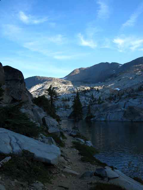
Around Fontanillis Lake A brief hike South from the North Shore of Fontanillis Lake brings us up and over the mountain shoulder that separates the bodies of the Northern and Southern wings of Fontanillis Lake. Climbing up this rock feature on the Northeast shore of Fontanillis Lake our trail bends away from the lake to climb up to a course paralleling the Eastern shore of Fontanillis Lake, but from above. The trail begins to bend down to pass near the South end of Fontanillis Lake before beginning the climb up to the third Bayview Trail junction. The Southernmost of the three Bayview Trail junctions is located to the East, above the gap between North shore of Fontanillis Lake and the South shore of Dicks Lake. Our hike up to the third Bayview Trail junction brings us up to access to our Southbound trail's route traversing up the steep bowl high above the East shore of Dicks Lake to Dicks Pass. Phipps Pass to Heather Lake Instead, I cut off the trail at the South end of Fontanillis lake, headed down to the lake, and found a nice little campsite on its Southeastern Shore. Time to kick back. |
 |
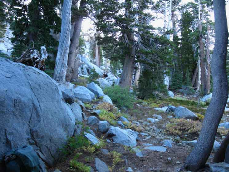 |
| Campsite on Southeast side of Fontanillis Lake. | View from camp site: Forest and Rock tilted down towards Fontanillis Lake. |
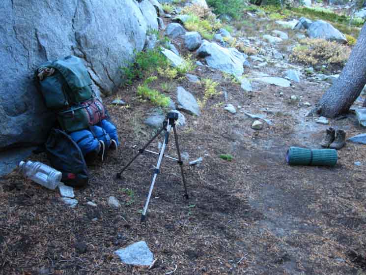
Camping Notes
|
Last page North: Fontanillis Lake I top of page South: 3rd Bayview Junction
Night two |
The Hiking Plan in motionConsidering
|
Backpacking North Trail Guide |
 |
Backpacking South Trail Guide |
Backpacker ForumsWe've got High Sierra backpacker Trails and backpacking topics forums. Check them out: Open up your own account where you can make and keep planning and trip notes and Post up informational pages in all the Trails and Topics forums.Become a MemberHave you comments, questions, or experiences and advice about approaching the beauties of Fontanillis Lake?Put them on the Trails Forum for Fontanillis Lake below. Add your experiences, comments, or pictures about thisTrail Section
|
North: Fontanillis Lake I South: 3rd Bayview Junction
Trailhead

Backpacking Lake Tahoe to Mount Whitney
Your guide to the High Sierra Crest, including the Tahoe to Yosemite, Pacific Crest, and John Muir Trails
