

High Sierra
Backpacking
Trail Guide
Forums
Sierra
Weather
WeatherNotes Northern
Sierra Weather
Gear
Finding
the
Echo Summit Trailhead
Trailhead option for local and Lake Tahoe to Mount Whitney backpacking trips
Languages
Trail Skills
Mountain
Safety
Food
Planning
Trail Arts
More
Information
Social
Trail Guide |
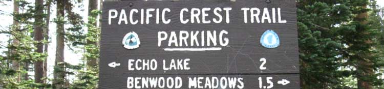
North Echo Summit TRAILHEAD |
South South of Echo Summit |
Topo Trail Map Echo Summit to Carson Pass |
Trail Maps INDEX |
Trail MILES and ELEVATIONS |
Trails Miles and Elevations INDEX |
Tahoe to Whitney on YouTube |
Locating
Echo Summit Trailhead
Views of Highway 50
East and Westbound
BACKPACKING ECHO SUMMIT TRAILHEAD
into
Meiss Country Roadless Area
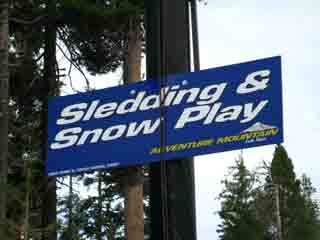
Adventure Mountain Adventure Mountain had rope-pull "lifts" from their lodge, all tailored for little-kids and families during Wintertime. It's always been closed during Summer when I walk past... |
Echo Summit
on a
Road Map
Road and Trail Maps
The trail marked as the Tahoe Rim Trail on the above map is also the route of the Tahoe to Yosemite and Pacific Crest Trails. As a matter of fact a small segment of the trail from our crossing point of Highway 50 (be careful!) is also part of the Pony Express Trail. |
North: Echo Summit South: South of Echo Summit
Local Knowledge Review the Meiss Country Backpacking Map above. Meiss Country Roadless Area is a locals' favorite for quick getaway short backpacking trips during Summertime, and some real fun adventures for Winter travelers. Local Weather
Hiking Map South Add Your Experiences Well, the most common trip out of Echo Summit is South to Showers Lake and back. The Meiss Country Roadless Area offers much more than this fourteen mile round trip to Showers Lake from Echo Summit and back. The hike from Echo Summit to Showers Lake and back covers about a third of this compact semi-wilderness area. The twelve miles across the whole Meiss Country Roadless Area to Carson Pass from Echo Summit is a shorter trip, but it reveals much more of the terrain while hiking across the heart of this amazing little gem of an "almost" Wilderness Area.
Meiss Country Roadless Area This is where I first started formally expanding Summer backpacking trips into Spring and Fall snow trips, then eventually mid-Winter travel as I developed gear & skills. The time spent exploring and becoming comfortable with the Meiss Country Area during Summertime becomes valuable Wintertime information as our backpacking skills expand to first explore the diminishing power of Winter during snowy Spring trips, then into the deepening cold and potential explosiveness of Fall conditions, and finally into Full Wintertime trips as our capabilities grow and consolidate with experience. The Meiss Country Roadless Area possesses a range of terrains from open mountain and meadows to an incredibly complex South Upper Truckee River drainage buried in deep forest climbing from Lake Level to the Tahoe Rim offering a broad natural canvas for our exciting development of basic backpacking skills, of their careful transition from Summer to Spring, Fall, and eventually Wintertime backpacking trips as we evolve. It a fine classroom, and delightful experience. There's lots of potential experience packed into this tiny place across each seasonal transition of Nature and our backpacking skills. Meiss Country can grow on you, and its utility can grow along with your development as a four-season backpacker. It is not alone. You can find your own, "Meiss Meadow," meaning your favorite hiking area in the High Sierra that you thoroughly enjoy and identify with that you can thoroughly explore during Summer as part of the preparation for your first snow trips. Explore your suitable favorite local High Sierra areas to experience the receding powers of Spring storms while snowshoeing across the diminishing snows of Spring. The topography of Meiss Country is helpful as it offers a range of difficulties suitable for evolving snow backpackers. Meiss Country can be a vital part of a balanced life, meaning a part of a balanced four-season backpacking schedule. And, because it is a small wedge of terrain in the Southwest corner of the very over-developed Lake Tahoe Basin, it turns the disadvantage of over-development into an extra factor of safety for Winter travelers. This is good. This means escape lays in a couple of directions from almost anywhere we can get in trouble in Meiss Country. The next areas we will explore as Winter backpackers have no nearby outposts of civilization. We will be on our own. If things go crazy bad, Meiss Country is fairly easy to push out of to safety during Summer or Winter. Meiss Country is an exceptional place both to introduce backpackers to the rigors of High Sierra Summertime travel and to for experienced backpackers to make the transitions to Winter backpacking in an educated and informed manner. Hear the chorus of lawyers singing in my ears? I do!
My Goal While carrying a heavy pack efficiently over High Sierra Terrain during Winter? Not here. Move along,... nothing happening here... just another pretty view... A pretty view not just of Nature, but of the evolution of our natural skills of natural engagement.
Our inherent ability to move over the most difficult terrains on this planet does not come finished. It requires some training and development to bring out. Thus I suggest a program, a system. Our ability to carry heavy loads under extreme weather conditions over the most difficult terrains in the world are the results of multiple evolutions, of the repeated exercises of a wide variety of physical and psychological, I would more precisely define the mental aspects of these evolutions as evolving our spiritual assets. Nature has created a unique "perspective," with a unique combination of perceptive and physical tools in each of us. Society can only go so far in defining that perspective, and its purpose and meaning. Only Nature can finish the job it started. Only you can put yourself there. This requires a training program feeding a regular schedule of High Sierra backpacking trips. Or a schedule exploring your local natural access points, where these skills can be exercised, If you live distant from the High Sierra. The evolution of this program will first get the feet steady and strong on maintained trails under a load, then begin probing unmaintained trails to evolve our route-finding, growing into evolving Navigation Skills we use for cross country travel during Summertime, and finally to locate and navigate the best routes across the naked Sierra during Wintertime... ...while in the meantime developing the fitness and perception required step by step. Stepping into the Meiss Country Roadless Area could be the next steps on your evolution as a backpacker. If not at Meiss, then at your version of the Meiss Country. Send me a picture of you and/or your crew at the trailhead or hiking these trails. Or at the top. I'll post it up on the forum. Maybe even the guide. Continuing South down the trail from Echo Summit we will observe and record various backpacker encounters, their impressions of the trails, and do our best to recount their unique trips and experiences, all to learn more about approaching local terrain from both the locals and the long distance hikers we encounter. I expect you to contribute along the way, when, and from where your Sierra explorations carry you. |
||||||||||||||||
Echo Summit to the Carson Gap The Human Aspect The following pages South across the 12 mile width of the Meiss Country Roadless Area around the bottom of the Tahoe Basin record both the terrain as well as encounters with day hikers like Charlie Tobias who make visits to the Tahoe Basin specifically to explore the High Sierra terrain through extensive day hikes. Check out links to Bob Burd's extensive day hike peak-bagging in every quadrant of the High Sierra, and hiking reports and experiences at Backpack the Sierra. They tell us there are many ways to explore Nature. The detail in terrain is infinite, even in "small" areas like Meiss Country. We could spend extended time here studying it carefully, or we could hike a whirlwind day or one night hike the longest way around Meiss Country. We should start with what we want out of the trip, the physical resources we bring to the trailhead, and how much time we have. These three factors determine the outlines of most trips. Echo Summit to Carson Pass On the other hand we briefly encounter long-distance backpackers hiking the Pacific Crest Trail, like Rocket Man, and Mighty Mike hiking the Tahoe Rim Trail. Rocket Man was running behind and therefore running hard. The long PCT hikers are rushing to Canada as quickly as they can. In the middle of these hiking extremes between day hikers and PCT hikers we find guys like Peter and Jason hiking a sweet 14 mile round-trip into Showers Lake and back to Echo Summit with their dog for a bit of relaxing weekend fun. Sweet. All Sweet. I recently received some images and notes from Winter hikers who snow-shoed into the Tahoe Rim near Sayles Canyon from near Camp Sacramento that will be added to the Sayles Canyon trail junction page. So post up your experiences here, on one of the guide page South down the trail into the Meiss Country, or shoot me an email and I'll incorporate your experiences, advice, and wisdom into the guide and forum for others to learn from and enjoy. Well, I'm trying. As of May 2017 this site is still in the construction phase. Bear with me. The whole North end of the guide is finally done, and you are currently experiencing its rough birth from "draft" to final copy. Meiss Country is amazing, and it is your reflection of this beauty that gives it "legs," being endowed with the self-reflective aspect of life, or "meaning," depending on how you look at it. That's why I ask you to tell me what you see. How you look at it opens up or closes down whole aspects of meaning and experience. These are nifty trails through terrain suffused with ancient forces that have sculpted, and been sculpted by human history. Your hike through here is another layer of that history. We humans are in fact one of those ancient forces. |
Hiking South
from the
Trailhead parking lot
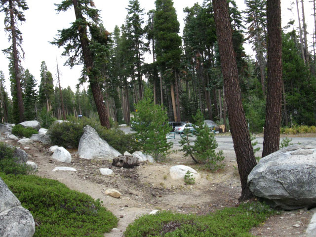 |
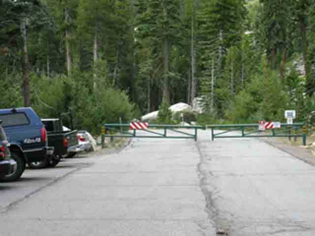
| looking back (North) at the parking lot and trailhead while hiking South from the Echo Summit Trail Head. See the green gate for Adventure Mountain down there by the white car? |
North: Echo Summit South: South of Echo Summit
Google Road Map
|
Echo Summit |
Modification
Hiking the Tahoe to Yosemite Trail Food = Time
I arrived at the Echo Summit trailhead hiking South on the Tahoe to Yosemite Trail as the sun was rising. It had only been a short walk up from my stupid emergency "throw-down" campsite alongside Highway 50, but I stopped and took off the pack to scout about, and take pictures for this trail guide. Any excuse to take this frkn stupid heavy pack off for a couple of minutes. Harness of Pain and Pleasure my ass. Harness of Pain. I had just finished my '09 Tahoe to Whitney hike, but this pack was real heavy. Because I stopped I was lucky enough to meet Randy, who had gotten stranded and spent the night at the trailhead due to the bad battery in his car. Randy was ready for anything. He had gear and food in his car sufficient for the worse circumstances driving around the Sierra can throw at him if his car broke down, so he relaxed and enjoyed a nice night car camping at the Echo Summit Trail Head when his car broke down. Smart Guy. The High Sierra Mountain Safety News is full of folks who were not properly prepped for when things inevitably went wrong. When life threw an unexpected twist at Randy he was properly geared to take advantage of the situation and enjoy it. This is much better than suffering. Getting stranded became a pleasant overnighter car camping at Echo Summit. On my part, I enjoyed meeting Randy. It was my luck he got stuck. As I mentioned earlier, I was packing the full load of food necessary to hike the 184 miles from Meeks Bay to Tuolumne Meadows, and the pack was still damn heavy at 70+lbs after two days of eating on the trail. Yet I was still a bit worried about having enough food to make the distance. Time to Calculate By my estimation I was running tight for food, which required I push up the miles until I came back within a reasonable food supply for the remaining miles. A calculation. By my calculation I was still counting my 600 calorie freeze-dried dinners as one meal, so I was keeping high standards. If I really get short of food I break the dinners in half. But I was close. Randy solved that problem. Randy turned me on to over 2000 calories contained in a load of quaker oats snack bars, oatmeal packs, and hot chocolate portions. I kicked back with Randy and chowed down on snack bars. Man, that food was trail gold. The more he fed me the longer I could stay. I had been tight with my food. Now I had time to kill. 2000 calories equals between 2/3rds and a full day of extra time on the trail. This load of calories gave me leisure time, time to kick back with Randy without worrying about running out of food further down the trail. I now had enough food to take at least a day off, or two half-days. I believe it was my 1998 or 1999 Tahoe to Whitney hike when PCTers christened me with the trail name, "The Calorie King." I would talk about hiking in terms of calories. Hikers figured that deserved the title "Calorie King." This unexpected boon gave me the time to slow down a bit, which instantly halved this day's miles. As I mentioned, my pack was tipping the scales at well over 70 lbs. Hell, when I made my first calculation of pack weight I omitted my eight pound "trail guide writer" payload. I carry two cameras, a tripod, a mess of batteries, and a charger that weigh out at between 7 and 9 pounds. The best time to run hard due to lack of food is when your pack is not weighed down with food! A few calories significantly changed my hiking plan. Slack. Thanks, Randy Dude. Trail Angel. I kicked it at Echo Summit for a couple of hours until Randy got a jump for his battery, then I headed South into the Meiss Country Roadless Area towards Showers Lake, where I intended to spend the fourth night on the trail towards Yosemite after a very slack 7.6 mile day. That was nice after starting with two 15 mile days. I hate doing that. I'd much prefer to work up to 15 than start cold at 15 times two. It's tiring to start at 15. Again, I'm glad I met Randy! But don't depend on trail angels. They happen, for sure, but we've got to be ready to pull the long and hard lengths of trail we are thrown into when things go bad. Things go good and bad on the trail. Be ready to deal with both.
The wisdom of
7.5 Trail Map
30 min Trail Map
Next page |
Backpacking Trail Guide
North
|
 |
Backpacking Trail Guide
South
|
Backpacker ForumsGot something to say? Say it here: Post it on Also see the Tahoe to Whitney trail Section and Backpacking Topics Forums.
Here you can add your experiences, comments, questions or pictures about the Echo Summit Trail Head, or the Echo Summit to Carson Pass section of the trail: Section
|
North: Echo Summit South: South of Echo Summit
Trailhead

Backpacking Lake Tahoe to Mount Whitney
Your guide to the High Sierra Crest, including the Tahoe to Yosemite, Pacific Crest, and John Muir Trails
