

High Sierra
Backpacking
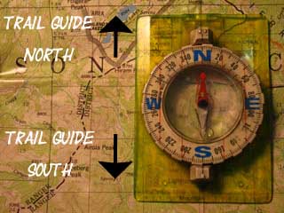
Trail Guide
Forums
Sierra
Weather
WeatherNotes Northern
Sierra Weather
Gear
Backpacking
Echo Summit Trailhead
into
Meiss Country Roadless Area
A Lake Tahoe to Yosemite & Mount Whitney & Points South Trailhead
Languages
Trail Skills
Mountain
Safety
Food
Planning
Trail Arts
More
Information
Social
Tahoe Trail Guide |
North Lower Echo Lake to Echo Summit |
South Locate Echo Summit trailhead |
Topo Map |
Maps INDEX | Miles and Elevations |
Miles and Elevations INDEX |
Tahoe to Whitney on YouTube |
Hiking
the
Echo Summit Trailhead
North and South
RESOURCES| Hiking Map North Desolation Wilderness |
Hiking Map South Meiss Country Roadless Area |
Video Playlist |
| Meeks Bay to Echo Summit NORTH Desolation Wilderness Miles and Elevations |
Echo Summit to Carson Pass SOUTH Meiss Country Roadless Area Miles and Elevations |
SOUTHBOUND Well, virtually nobody except very long distance backpackers on their way North, and maybe a few day hikers would hike North out of the Echo Summit Trailhead. Two Miles out of the Wilderness These structures, roads, and forest sit on the Easternmost Nose of the ridge running East & West around the South Shore of the Echo Lakes. The next two miles to our North from Echo Summit cross a gap in the wilderness that's filled with some bits of civilization between the North end of Meiss Country Roadless Area to our South and Desolation Wilderness to the North. The vast majority of folks hiking Northbound through Echo Summit are PCT hikers or PCT section hikers hiking North on their way to Canada, and clockwise hikers on the Tahoe Rim Trail. Desolation Wilderness to the North Folks planning on backpacking North from Highway 50 will park at the Lower Echo Lake upper parking lot to stage up for Northbound backpacking trips into Desolation Wilderness through the Lower Echo Lake Trailhead. Thus this Echo Summit Trailhead and parking lot mainly serves hikers and backpackers moving South into the Meiss Country Roadless Area.
No Permits Required for Meiss Country Backpacking This is especially important for backpackers on the Tahoe to Yosemite Trail who wish to camp at Round Top Lake on your way over into Summit City Canyon. Make sure you specify that on your permit. If all the designated campsites are full, find a nice non-obtrusive spot and throw down. No problem. You have a permit.
Meiss Country Roadless Area
Note |
| Index for Echo Summit Trailhead |
||||||||||||||||||
Trail Notes: Southbound South of Echo Summit: Meiss Country Hikes Trip Distances North and South from Echo Summit Lake Tahoe Resources |
Weather Resources
|
Getting to Echo Summit Trailhead, Overall impressions Map and Miles Information Meiss Country Topo Hiking Map Echo Summit to Carson Pass miles and elevations |
||||||||||||||||
| > Forum < | ||||||||||||||||||
Hiking South into Echo Summit Trailhead
 |
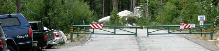
Hiking South into the Echo Summit Trailhead along the Tahoe to Yosemite Trail. We are bending Right, South, off this last section of our trail paralleling Highway 50 up to Echo Summit from our crossing point a little lower down the West flank near Little Norway. We see the Echo Summit parking lot coming into view, and the trailhead sign across the parking lot. |
Trail Notes
Entering
|
North: Lower Echo Lake to Echo Summit South: Echo Summit 2
Local Trailhead - Long Backpacking Trips
ECHO SUMMIT TRAILHEAD TYT and PCT Each of these PCT section hiking destinations along the successive mountain pass trailheads to our South are each shorter options than hiking the whole remaining 150 miles down the Sierra Nevada crestline along either the Tahoe to Yosemite or Pacific Crest Trail routes to Tuolumne Meadows in Yosemite. These section hikes are great for folks who want to hike from Tahoe to Yosemite over the course of a few seasons, rather than all at once, for whatever reasons. These are fantastic hikes for all of you medium distance section hikers out there. These are amazing sections of trail, and their shorter distances than a "flat-out" long-distance backpacking trip can give us a bit more time and energy to explore our surroundings over the course of more leisurely-paced section hikes.This can be a real nice change from being forced to push through at the quicker pace and longer daily mileages demanded by long distance backpacking trips. The Tahoe to Yosemite Trail Lake Alpine lays 35.92 miles South of Echo Summit along the Tahoe to Yosemite Trail. Saint Marys Pass is 70.56 miles South of Echo Summit, and Tuolumne Meadows is about 150 miles South of Echo Summit Trailhead. The trail guide below covers both the PCT and TYT routes down to Tuolumne Meadows in Yosemite, so check them both out to see which route, section or local trip options along the way suit your backpacking needs, expectations, and capabilities. I believe that there is something for everyone on the trails between Lake Tahoe and Yosemite. Hopefully you are into hiking the whole thing with me.In any case, tighten up your pack straps. We're just getting-going and picking up speed after crossing the Desolation Wilderness! Crossing Desolation Wilderness was just getting us warmed up. In the meantime, Echo Summit's access to the Meiss Country Roadless Area has something interesting for every short, medium, and long-distance backpacker, so let's keep our eyes open as we hike through. |
Local Hikes and Backpacking Trips Check out our hiking Map of Meiss Country Roadless Area to see the relationship between these trailheads. Excellent backpacking trips across the Meiss Country Roadless Area are crafted between these trailheads. Let's hear about your experiences, comments and questions hiking long and short backpacking trips South out of Echo Summit. |
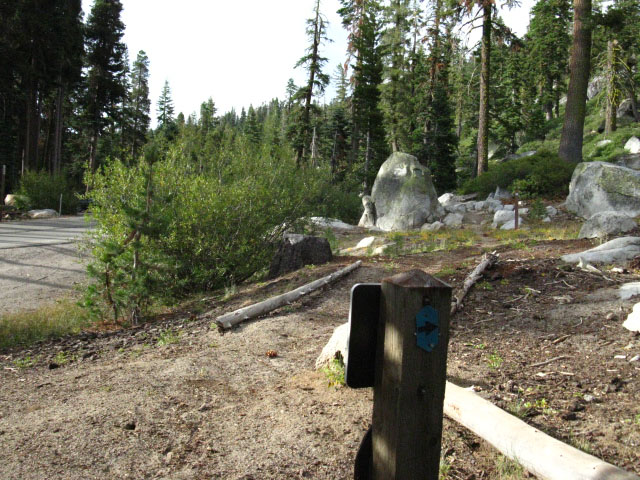
Trail Sign
at the
Echo Summit Trail Head
 |
Video and Pictures taken at Echo Summit, September 20, 2009.
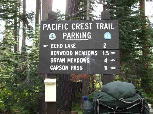
I put the distance to Carson Pass at 12 miles, as mentioned above and below.
Meiss Country Roadless Area
|
Trail Sign heading Northbound out of the Echo Summit Trail Head
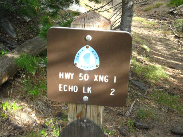
Above: The Northbound Trail out of Echo Summit is well marked. This sign is located at the NW corner of the parking lot close to Highway 50. The Northbound hiker walks against traffic West down Hwy 50 to our crossing point just East of Little Norway.
Long Distance Backpacker mileagesSouth on the Pacific Crest Trail
Echo Summit to: Carson Pass: 12 miles. Ebbetts Pass: 38.78 miles Sonora Pass: 68.22 miles Tuolumne Meadows: 142.02 miles
South on the Tahoe to Yosemite Trail Echo Summit to: Carson Gap: 10.61 miles. Lake Alpine: 35.92 miles Saint Marys Pass: 70.56 miles Tuolumne Meadows: 150.29
The Tahoe to Yosemite and Pacific Crest Trails split at Carson Gap. |
Echo SummitIf you've started your backpacking trip at Meeks Bay Trailhead, you have just completed 32 miles to get here.Either your trip is over, or you are just picking up speed on the Tahoe to Yosemite route on our way to Lake Alpine and our 1st resupply point at the Lake Alpine Lodge on Highway 4. On the other hand, you may just be starting your Southbound trip on the Pacific Crest Trail to Carson Pass, Ebbetts Pass, Sonora Pass, Yosemite, or Mount Whitney from Echo Summit. In that case, Good Luck! The third option is that you are moving North on the Pacific Crest Trail.
|
NORTH |
Bail Out, Rest, Resupply, and Repair Echo Summit overlooks South Lake Tahoe. Echo Summit sits a thousand feet above, and about 9 miles to the West of South Lake Tahoe. At South Lake Tahoe we can find excellent cheap accommodations, full grocery, backpacking, and bulk food supplies, freeze-dried food, and outdoors equipment retailers. Need to replace that broken hip strap buckle? This is your big chance. |
Continuing North on the Pacific Crest Trail? Resupply Fresh Food is available at the Echo Lake Chalet. |
|
| top of page |
South Lake TahoeRest & Resupply I figure that South Lake Tahoe is the Mammoth Lakes of the North. At Mammoth Lakes it is customary for me to spend a couple of nights at the Hotel 6. South Lake Tahoe has the High Country Lodge. Both have given me backpacker discounts. Really. The key is not to show up on a busy weekend. That's always expensive. I go to Roberto's, and Angles BBQ for huge great dinners and lots of water and beer in Mammoth Lakes. South Lake Tahoe has Izzy's Burger Spa, Ernie's for breakfasts, and countless places with 12 to 15 dollar Prime Rib. Mammoth Lake's Breakfast Club is a classic, and the Good Life Cafe is a modern version of The Breakfast Club, with hippy omelets. South Lake Tahoe has Ernie's. I don't carry a pack for two full days when I hit Mammoth Lakes. Many Pacific Crest Trail hikers can use a little break before exiting the High Sierras North of Lake Tahoe, as the length of the Sierras is always a tough go. Now that you are departing the high elevation range, your daily mileages will really begin to pick up. The hard hiking conditions in the Sierra Nevada between Mount Whitney and Lake Tahoe keep the Pacific Crest Trail hiker's mileages low. Most PCT hikers drop down to, or below 20 miles per day. You may need a little rest before continuing North. South Lake Tahoe is a cool place to kick it for a couple of rest days of rest and recovery. Remember, sometimes we have to slow down to speed up. I figure that Northbound backpackers on the Pacific Crest Trail may be ready for the Northern version of this type of custom rest, restore, and feeding break at South Lake Tahoe that Mammoth Lakes offers in the South Sierra. That's why I made the |
top of page
Where We Are
Echo Summit on the Road Map
Echo Summit Video with Randy
|
Directions The Echo Summit Trail Head is located on Highway 50 less than 100 yards West of Echo Summit. The Trailhead is located on the South, or Right side of Highway 50 if you are traveling Eastbound....West bound travelers cresting Echo Summit should immediately look for Echo Road, on their left. Just past Echo Road on Highway 50 you will see a large blue "Sledding and Snow Play" sign which marks the road to Adventure Mountain, where the Echo Summit trailhead is located. If you see "Little Norway" on the Right while traveling West, you have gone about a mile too far....When East bound travelers see "Little Norway" on their left, look to make a right turn within a long mile. Turn down the road where you see the blue "Sledding" sign on your right. The trailhead is a short ways down the road to Adventure Mountain. |
North: Lower Echo Lake to Echo Summit South: Echo Summit 2
Google mapEcho Summit, Meeks Bay, and S Upper Truckee trail heads. |
Echo Summit Backpacking Options |
Physical Location of the TrailheadThe Echo Summit trail head sits on Highway 50 just to the West of Echo Summit, and a bit West of Echo Road. The trailhead parking lot is on the South side of Highway 50, down the road marked by the blue "Sledding Snow Play" sign shown on the next page. There is no public transportation to Echo Summit from East or West, but there's plenty of parking at the trail head for drivers. Backpackers who take public transportation into South Lake Tahoe should have little problem hitch hiking up to Echo Summit trail head. The whole Tahoe region is full of wilderness and outdoor lovers who pick up backpackers. Once you get into the Sierra Nevada Mountains, hitch hiking is fairly easy. Hitching in California's urban areas is crazy. It is like hitching in a foreign country. The Meiss Roadless Area South of Echo Summit we enter the Meiss Roadless Area. This area is roughly bordered on the East by Highway 89, on the West by Highway 50, on the North by Christmas Valley (Meyers), and on the South by Highway 88. The Meiss Roadless Area is also part of the Lake Tahoe Basin Management Unit, as are all National Forests, Wilderness, and special zones such as the Meiss Roadless Area, that sit within the the watershed of the Lake Tahoe Basin. Every Wilderness and National Park within the Tahoe Basin was subsumed by the LTBMU. This was to comprehensively monitor and manage the public lands affecting Lake Tahoe. Check out the history of the LTBMU.
Maps Meiss Country Roadless Area map pdf
USGS Topo Map Meiss Roadless Area
Echo Summit Echo Summit is one of our potential trailheads for long distance backpacking South towards Yosemite and on to the John Muir Trail South to Mount Whitney. There are also many short distance backpacking trips South into the Meiss Roadless Area that we can and should explore.
Echo Summit From Echo Summit we can craft many fine medium distance backpacking trips South. If we are headed North, we would be better served using the Lower Echo Lake Trailhead, which is the main Southern access point North into the South end of the Desolation Wilderness along the Northbound Pacific Crest, Tahoe Rim, and Tahoe to Yosemite routes.
The Lower Echo Lake Trailhead is two miles North of Echo Summit. Basic Southbound long distance trips from Echo Summit include: Echo Summit to Ebbetts Pass at 38.78 miles Echo Summit to Sonora Pass at 68.22 miles,
Echo Summit to Tuolumne Meadows, measuring in at 142.02 miles along the Pacific Crest Trail route.
Echo Summit Our main short distance backpacking options involve departing Echo Summit Southbound and crossing the Meiss Roadless Area to exit through the one of the Roadless Area's other trailheads. Or we can backtrack to the Echo Summit trailhead.
Our main destination options are: The trailhead at the
The trailhead at Meyers (14.6 miles)
We can exit the Roadless Area through the Big Meadow Trailhead on Highway 89, which is .13 of a mile less than the 14.6 miles down to the Meyers Trailhead. Each of these trips is between 10 and 12 miles in one direction, are of moderate difficulty, and follow well-used, well-marked, and well-maintained trails.
Overall The Meiss Roadless area is an excellent hiking and backpacking location that offers intermediate-skilled backpackers an excellent introduction into High Sierra Backpacking. The elevation is high, but not too high. The distances between trailheads are not too long, nor too short. The terrain is challenging, but all the difficult sections are just a few miles long, and all lead us to Meiss Meadow, a huge almost-flat meadow that sits below the Southern corner of the mountains making up the bottom of the Tahoe Basin. Meiss Meadow is namesake and the center of the Meiss Country Roadless Area. Meiss Meadow is the hub of the Meiss Roadless Area with trails radiating out to its main and minor trailheads. There are other fine trails in the Meiss Roadless Area, such as the trail over Little Round Top, and the routes down to Strawberry on Highway 50. Though Meiss Country is just a couple of miles South of the Desolation Wilderness, it is much quieter and less traveled than Desolation. The beauty in Meiss is subtler and of a more quiet and subdued character than that of the Desolation Wilderness. You will notice the difference.
7.5 Backpacking Topo Map
30 min Topo hiking Map
Next page |
Backpacking Trail Guide
North
|
 |
Backpacking Trail Guide
South
|
Backpacker ForumsGot something to say? Say it here: Post it on The forum is divided into Trails and Topics Forums
Add your experiences, comments, questions or pictures about the Echo Summit Trail Head on the Trails Forum: Section
|
North: Lower Echo Lake to Echo Summit South: Echo Summit
Trailhead

Backpacking Lake Tahoe to Mount Whitney
Your guide to the High Sierra Crest, including the Tahoe to Yosemite, Pacific Crest, and John Muir Trails
