The Trails
Guide
Maps
Miles/Ele
Permits
Resupply
Forum
Current Weather Conditions
Weather Notes
Northern High Sierras
Central High Sierras
Southern High Sierras
Gear
Gear List
Gettin Started
Layering
Discussion
Testing yourself and your gear
Gear Reviews
Carson Pass to Highway 4
Backpacking Topo Map Index
East and West Flanks
of the
Mokelumne Wilderness
Backpacking Maps Indexes
Pacific Crest Trail and Tahoe to Yosemite Trail
Languages
Translate
Trail Arts
The art of walking
Physical Preparation
Trail Skills
The trail
Off the trail
Scrambling
Maps
Navigation
Camp skills
Food
Resupply
Food
Other
Photo Categories
Trail Stories
Trail Culture
News and Science
Links
Groups
Books
ALL |
MAP TYT-PCT |
MAP TYT-PCT |
REGION TYT-PCT |
LOCAL TYT-PCT |
MILES |
TRAIL TYT-PCT |
TRAIL |
Carson Gap
above
Highway 88 south to Highway 4
Backpacking
|
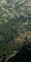
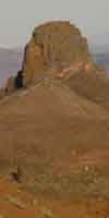
Hiking Introduction Though we view the Mokelumne Wilderness from the perspective of long-distance Southbound backpackers on the main long-distance trails. Along our way we are going to find endless excellent short, medium, and long distance backpacking trips that are well suited for shorter trips to better explore the Mokelumne Wilderness. These are mostly in and out trips along the same route, or trailhead to trailhead hikes. The reason for this is a lack of connector trails between the Pacific Crest and Tahoe to Yosemite Trails across the Mokelumne Wilderness is the TYT-PCT wrap around different flanks of formidable terrain features decorating the heart of the Mokelumne Wilderness. The maps below show us why. The Mokelumne Wilderness has many less loop routes than the Carson Iceberg or Emigrant Wilderness to our South, or the Desolation Wilderness to our North. This makes section hiking either the PCT and/or TYT our best bets hiking though the Mokelumne Wilderness. There's really not a practical loop that we can hike around the Wilderness by tying together the PCT and TYT, as there are in the Carson Iceberg and Emigrant Wilderness to our South. To loop the Mokelumne we would either have to hitch-hike between the Lake Alpine (TYT) and Ebbetts Pass (PCT) Trailheads on Highway 4 or continuing South across Highway 4 (on either the PCT or TYT) to the Highland Creek Trail in the Northern Carson Iceberg Wilderness. The Highland Creek Trail is the first trail connecting the TYT and PCT once we hike South of Blue Lakes on the PCT or turn down Summit City Canyon on the TYT. The terrain in the Mokelumne Wilderness is very unlike the Emigrant and Carson Iceberg Wilderness to our South where multiple connector trails link the PCT and TYT together, which opens up a heck of a lot of excellent long distance backpacking loop trips around both these fantastic wilderness areas. Not so in the Mokelumne Wilderness! It's one route or the other across the Mokelumne Wilderness. Permits The Long Perspective PCT EAST The Toiyabe National Forest covers Everything East of a line drawn North and South along the Sierra Crest from the crest of the Carson Range (bounding the Eastern and Southern shores of Lake Tahoe- the Sierra Range wraps around Tahoe's West Shore) South all the way down to Tuolumne Meadows. Three National Forests cover the same distance along the Western flank of the Sierra Crest. Administrative Anomalies Permits entering the Mokelumne Wilderness from the East are had from the Carson Ranger District of the Toiyabe National Forest from Carson Pass down to just North of Sonora Pass. The Bridgeport Ranger District handles East Sierra permits from just North of Sonora Pass down to the bottom of the Hoover Wilderness at Virginia Lakes. Lake Alpine, where the route of the Tahoe to Yosemite Trail crosses Highway 4, sits about 15 miles West of Ebbetts Pass down Highway 4. Lake Alpine and its trailheads North and South are administered by the Calavaras Ranger District of the Stanislaus National Forest. The administration of the Mokelumne Wilderness on its Southern side along Highway 4 is also split following the roughly Southwestern bending course of the North Mokelumne River. See the maps below for the visual details of these boundary lines. The links along the top of this page leads to the contact information for these National Forests and their Ranger Districts that issue permits for whichever direction we enter the Mokelumne Wilderness. |
Topo Hiking Maps for Carson Gap to Lake Alpine |
||||
7.5 min |
|
30 min USGS Backpacking Maps 1:100 000 |
||
Big Map
Big Map
Detail Map
Detail Map
Big Map |
New
30 minute maps 1> Echo Summit to Round Top Lake
2> Echo Summit to Lake Alpine
1x2 Topo Bad Test Map |
|||
| Click the Red Dots on the Topo Maps for the related Trail Guide page. | ||||
Miles and Elevations on the Tahoe to Yosemite Trail between Carson Gap and Lake Alpine |
||||
|
|
||||
The next map South Lake Alpine to Saint Marys Pass This Large Map will give you context on the proximity of trails and resources: Carson Pass to Bensen in Yosemite, 1x2 topo |
||||
| This map tracks the Tahoe to Yosemite trail South into ... | ||||
|
||||
The Pacific Crest Trail |
||||
| The Pacific Crest Trail enters the Mokelumne Wilderness via the Toiyabe National Forest at Carson Pass. The boundary between the Toiyabe and El Dorado National Forest follows the Sierra Crest through the Carson Pass. Though the Carson Pass is split between National Forests, the El Dorado National Forest administers the Carson Pass through the Carson Pass Management Area. |
||||
Topo Hiking Maps for Carson Pass to Ebbetts Pass |
||||
| 7.5 min USGS Backpacking Maps 1:24 000 |
|
30 min USGS Backpacking Maps 1:100 000 |
||
Big Map
Carson Pass to Lost Lakes & Lost Lakes past Blue Lakes
Blue Lakes to U. Sunset Lake
Upper Sunset Lakes to Ebbetts Pass |
New
30 minute map Carson Pass to Ebbetts Pass
1x2 Topo Bad Test Map |
|||
| Click the Red Dots on the Topo Maps for related Trail Guide page. | ||||
| Miles and Elevations on the Pacific Crest Trail from Carson Pass to Ebbetts Pass |
||||
|
||||
The next map South Ebbetts Pass to Sonora Pass The Large Map below will give you a grand context on the locations of trails and resources through the Mokelumne Wilderness. Carson Pass to Bensen Lake in Yosemite, |
||||
| map index North Echo Summit to the Carson Pass Maps |
||||
MAPS North: MEISS COUNTRY MAPS MAPS South: EBBETTS PASS to SONORA PASS
Map CreditFree USGS Topo Hiking Maps |
U.S. Geological Survey, Department of the Interior The I love these folks. Move the Map to the Sierras. Select size of Maps you wish to locate. Click "Mark Point" on map to see the USGS map grid of the selected map scale. Set up folders to download these bad boys into, then fire them up in Adobe Reader. The crappy terrago toolbar will help you measure miles, if it does not screw up... update If programmers listened to users, software would be better... USGS Topographic Maps |
High Sierra Backpacking Map |
||||||||
Backpacking Map Information and Instruction
USGS MAP LOCATOR Free USGS Maps for Downloading
MAP NOTE What's important for our general reference purpose is that each side of a square is 1000 meters, or a Kilometer. From my point of view that is 1000 yards or .62 of a mile. Diagonal: 1414.22 meters, if my trig is correct. That converts into 4,639.8 feet or .88 of a mile. |
Backpacker ForumsTahoetoWhitney.OrgBackpacking
|
| High Sierra Trails | High Sierra Topics |
All backpackers can post comments on the Forum.
Members can post their own pages in any of the trails and topics Forums with images, videos and text.
Section
CARSON PASS to HIGHWAY 4
Segment
HIKER INPUT
MAPS North: MEISS COUNTRY MAPS MAPS South: EBBETTS PASS to SONORA PASS
Trailhead
Contact
Alex Wierbinski