


Tuolumne Meadows Hiking Map
Backpacking Topo & Trails Map
| The South End of Combined Tahoe to Yosemite Trail and Pacific Crest Trail |
The North End of the Combined John Muir Trail and Pacific Crest Trail |
Four
USGS Backpacking 7.5 minute Topo Trail Maps

Maps |
Central |
Maps |
|
MAP PCT-TYT |
MAPS |
30 Minute |
Southwest |
Southeast |
JMT |
JMT |
PCT |
TYT |
|
Central |
30 Minute |
RESUPPLY |
Click Click |
|
|
Tuolumne Meadows
Region Backpacking Map
North PCT-TYT : Cold Canyon to Glen Aulin Trail Map JMT Southwest: Yosemite Valley Trail Map Click Red Dots for Guide Entries Click Labels for Adjacent Maps JMT Southeast: Lyell Canyon over Donohue Pass to Island Pass Trail Map
|
North PCT-TYT: Cold Canyon to Glen Aulin JMT Southwest: Yosemite Valley Click Red Dots Southeast JMT-PCT Southeast: Lyell Canyon over Donohue to Island Pass
Mapology |
||||
MAP NOTE What's important for our general reference purpose is that each side of a square is 1000 meters, or a Kilometer. From my point of view that is 1093.6 yards or .62 of a mile. Diagonal: 1414.22 meters, if my trig is correct. That converts the diagonal distance into 4,639.8 feet or .88 of a mile.
|
Tuolumne Meadows Tuolumne Meadows Resupply Page
Highway 120 Corridor
Highway 395 Corridor
Highway 108 Corridor
|
Our |
||
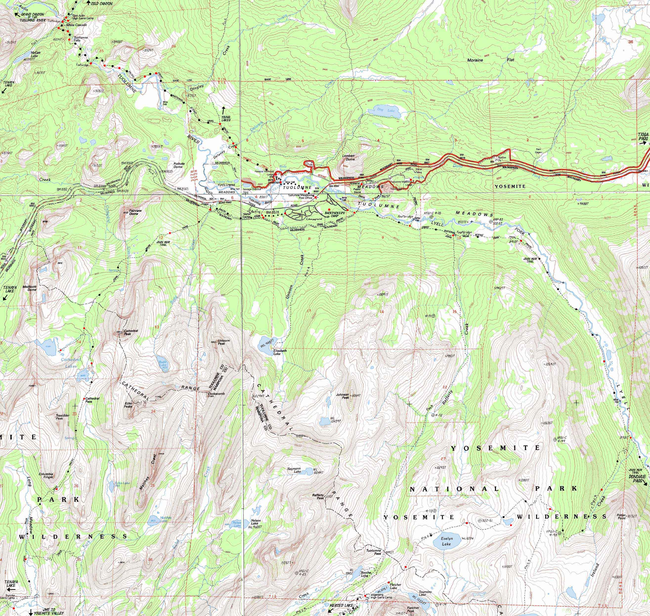
Main Features End The Tahoe to Yosemite Trail ends at Tuolumne Meadows. I never understood that. At Tuolumne Meadows we are sitting atop the great drop down a vast carved granite bowl to Yosemite Valley. End the Tahoe to Yosemite in Tuolumne Meadows? Hardly! We are going to drop like a bomb down to the Valley after enjoying two nights resting, recovering, and recreating in Tuolumne Meadows. Thus we are going to transition off the end of the Tahoe to Yosemite Trail onto the John Muir Trail, but running down the South flank of the Cathedral Range down to Yosemite Valley. Rather than joining the typical flow of Southbound John Muir Trail hikers who have just finished undergoing the brutal "transformation through fire" of beginning their epic journey with the very difficult hike out of the low elevation heat of the Valley up to the chill environment of Tuolumne Meadows. Hiking out of the Valley is a hard starting point, especially if your're out of shape, so be ready for the climb. But not us. We've already hiked down from Meeks Bay, and are contemplating the logistics of weaving in a hike down to Yosemite Valley on our way South to Whitney. But we are only marginally concerned with this climb we will be making when we depart the Valley, because right now we are concerned with laying out the best topo hiking trail maps of Tuolumne Meadows focusing on how to best tie together the junctions of Tahoe to Yosemite, Pacific Crest, and John Muir Trails to run us down to the Valley and back to the Crest again. This means we are concerned with the trails over the Cathedral Range and back again. Our route "over" will be by hiking past the Cathedral Lakes through Cathedral Pass on our "backwards" John Muir Trail route down into the Valley. If you follow our route to the edge of the map above you can click the label for the next map to continue. The bottom of this Tuolumne Meadows Trail Map leads to the next trail map of Yosemite Valley. Each of these custom Yosemite Trail Maps are much more than just abstract representations. The vast majority of the red dots on the map are linked to the trail guide entry for that position. These have views of the surrounding terrain and topography, samples of the typical hikers, backpackers, and professionals we meet on the trail, and even videos. But first, before beginning this fine leg of our journey down to the start point of the legendary John Muir Trail, we are going to stop, relax, soak in, and enjoy the fine environment at Tuolumne Meadows for a while. Representatives of the whole world come through Tuolumne Meadows, so I'm going to observe and talk to as many of them as possible. Then we are going to hike down into Yosemite Valley for a visit before we return to the Southbound John Muir Trail in Lyell Canyon via Merced Lake and Voglesang Pass.
Trail Culture Our Topo hiking map above, and our collection of Yosemite hiking maps don't just cover the high points along the John Muir, Tahoe to Yosemite and Pacific Crest Trails, which we do. But my hope is to put these fantastic trails into a wide enough context that first draws you out to explore the backbone of the Sierra Crest, then into all the nooks and crannies wedged in along its fantastic flanks between Tahoe and Whitney. Central Yosemite from Tuolumne Meadows down into the center of the rock heart of Yosemite Valley is just such a place. This is a special place because the granite rising from the 4000 foot floor of Yosemite Valley is atypical of the granite distribution along the Sierra Nevada Mountain Range. The granite rising out of Yosemite is more typical of the granite at the top of the range than at 4000 feet. Most locations at 4000 feet are rolling and rising scrubby foothills with maybe some Ponderosa Pine, and only a few knobby random granite outcroppings indicative of the great granite topping the range. The Emigrant Wilderness has a larger sweep of granite down the West Flank than the range to its North, and the Sierra to the South of Yosemite. The granites of Emigrant's West Flank run down to 6000 feet at Pinecrest Lake, with a finger of Cherry Creek's granite valley reaching down to Cherry Lake at 4000 feet of elevation. The massive granite drainage of the Merced River flows (flies?) into Yosemite's 4000 foot Valley Floor surrounded by thousands of feet of near vertical granite walls. This valley would be remarkable at any altitude, but being floored at 4000 feet, having a huge vein of vast granites running fully exposed all the way down off the 11, 000 foot crestline to 4000 feet is unprecedented. That's why this Trail Map of Tuolumne Meadows follows the JMT over the Cathedrals via Cathedral Lakes and Pass, then traces out the end of our route reconnecting with the JMT via Vogelsang on our way back. Preferred We have two fundamental trail options hiking South from Tuolumne Meadows. We can either break off our line hiking down the Sierra Crest to drop down the John Muir Trail "backwards" into the Yosemite Valley ("finish" the TYT in the Valley?), or end the Tahoe to Yosemite Trail by picking up the Southbound route of the combined John Muir and Pacific Crest Trails heading South down Lyell Canyon, essentially continuing our Tahoe to Whitney hike down the Sierra Crestline. I currently prefer hiking off the Sierra Crest down into the Yosemite Valley as part of what I call hiking the "Golden Triangle" route through the heart of Yosemite: Tuolumne Meadows down to the Valley, hang out and have fun in the classic beauty and historic juxtaposition of peace and chaos that is Yosemite Valley. Closed Loop The Big Turn On its Left side (West) we can see where we begin following the JMT Southwest up through Cathedral Pass and down past Matthes Crest on our way down to Yosemite Valley. Hiking the Golden Triangle as part of our Tahoe to Yosemite backpacking trip means we're going for a "long" version of the Tahoe to Whitney Backpacking Trip. I figure it adds about 54 miles to our trip total, compared to hiking straight through Tuolumne Meadows. High Sierra Camps These topo hiking maps depict more than Tuolumne Meadows. This map also shows the three High Sierra Camps around Tuolumne Meadows, two of which sit along our main routes through Tuolumne Meadows. High Sierra Camps are curiosities to me, some kind of relic from a past age that still hangs on. They have a nice culture of folks who work the High Sierra Camps that is overwhelmingly good, if they have not become too egotistical. Glen Aulin sits along our combined Tahoe to Yosemite/Pacific Crest Trails route as we hike South across the North Yosemite Backcountry. Sunrise High Sierra Camp sits along our backwards route down the John Muir Trail to Yosemite Valley. Voglesang High Sierra Camp does not sit along the Tahoe to Yosemite Trail, the Pacific Crest Trail, nor the John Muir Trail, but is on our route back to the John Muir Trail in Lyell Canyon from Yosemite Valley, where we will resume our Southbound hike to Mount Whitney from Lake Tahoe, after our delightful detour down to and back up from Yosemite Valley. Click the Red Dots to see the trail guide entries for each of these High Sierra Camps. The map above shows two corners of the Golden Triangle, the junctions marking its beginning and end. The bottom corner of the Golden Triangle is way down at the Happy Isles Bus Stop in Yosemite Valley.
Nice. |
Mapping, Mileage, |
|
See the Permit Office on the way to the Tuolumne Lodge on the East Shore of the Tuolumne River.
I have finally got the Yosemite National Parks permit page started, but I will offer some advice here: Walk into Yosemite. Don't even mess with getting permits there. Want to hike the JMT? Start at Sonora Pass. Drop down to the Valley backwards on the JMT once you arrive at Tuolumne Meadows, then reacquire the JMT in Lyell Canyon via Voglesang. Yosemite Permit Problems Solved.
Yes, I know that may not solve your permit problem. But it is a start. |
Tales from Topographic Maps: USGS Northwest Map Northeast Map Southwest Map Southeast Map
scale Contours
Compass Offset West map's East map's note: Vogelsang Peak cites 15 degrees, but the finished Tioga Pass puts declination at 14.5. Backpacking permitting authority National Park Wilderness Area Physical location |
North map: Cold Canyon to Glen Aulin South map: Lyell Canyon over Donohue to Island Pass or Yosemite Valley
| Elevations | Trail Forums Hiker Feedback |
More Trail Guide Information |
|||
Tuolumne Falls Tuolumne Meadows Cathedral Pass Vogelsang
|
Trail Forum
Trail Forum |
Trail Guide Guide Pages Trail Guide |
|||
Map Credit |
||
U.S. Geological Survey, Move the Map to the Sierras. Select size of Maps you wish to locate. Click "Mark Point" on map to see the USGS map grid of the selected map scale. You can download all the maps covering your backpacking trip using the USGS Map Locator.
|