
The Trails
Guide
Maps
Miles/Ele
Permits
Resupply
Forum
Current Weather Conditions
Weather Notes
Northern High Sierras
Central High Sierras
Southern High Sierras
Gear
Gear List
Gettin Started
Layering
Discussion
Testing yourself and your gear
Gear Reviews
High Sierra Nevada Mountain Range
Sierra Crestline
Backpacking Maps
Emigrant Wilderness -- Toiyabe National Forest -- Hoover Wilderness
and the
North Yosemite Backcountry
Backpacking Map
INDEXES
of the
Pacific Crest Trail
and
Tahoe to Yosemite Trail
Highway 108 to Tuolumne Meadows
Languages
Translate
Trail Arts
The art of walking
Physical Preperation
Trail Skills
The trail
Off the trail
Scrambling
Maps
Navigation
Camp skills
Food
Resupply
Food
Other
Photo Catagories
Trail Stories
Trail Culture
News and Science
Links
Groups
Books
ALL
TRAIL |
MAP TYT-PCT
|
MAP YOSEMITE |
MAP JMT-PCT |
REGION TYT-PCT |
LOCAL TYT PCT LOOP |
MILES |
TRAIL TYT-PCT Sonora Pass to Tuolumne Meadows |
High Sierra Backpacking Maps
Trail Section End of the North Sierra Nevada Beginning of the End The only longer section of trail between Tahoe and Whitney is our final (130?) mile section of trail from Muir Ranch to the Whitney Portal. The backpacking maps below cover this long and hard section of trail from Highways 108 to 120. Main Routes The TYT climbs to the Sierra Crest across the heart of the Emigrant Wilderness from Kennedy Meadows Pack Station's location way down on the Western Flank. Local and Long Hikes Wide Range of Map Coverage After the TYT & PCT merge in the Northwestern corner of Yosemite in the top of Jack Main Canyon the TYT breaks off one last time. The TYT loops around Tilden Lake before rejoining the PCT a couple of miles South of Tilden Lake between Bailey and Macomb Ridges. A Long Hard One This section from Sonora Pass to Tuolumne Meadows consists of sustained high difficulty trails and terrain. I consider the overall rating of a trip from Sonora Pass to Tuolumne Meadows as a to Store & Post Office Tuolumne Meadows
Black and Red Dots The red dots on both maps lead to trail guide reports for the selected location. |
High Sierra Stanislaus National Forest TYT-PCT |
|||||||||||||||
Topo BACKPACKING MAPS Kennedy Meadows |
|||||||||||||||
| The Best 7.5 minute USGS Backpacking Maps 1:24 000 |
|
The Best 30 minute USGS Backpacking Maps 1:100 000 |
|||||||||||||
TYT
TYT
TYT-PCT EAST-WEST LINK
TYT 3> Relief Reservoir
TYT 4> Emigrant Basin
Entering
OFF Trails OFF the PCT-TYT
PCT & TYT NEW MAP Trails OFF the PCT-TYT: Kerrick and Rodgers Canyons Trail Junctions into The Grand Canyon of the Tuolumne River
PCT & TYT 7> Bensen Lake NEW MAP Trails OFF the PCT-TYT:
PCT & TYT 8> Miller Lake
9> McCabe Lake
|
TYT & PCT
Emigrant, Toiyabe
Hoover Wilderness into North Yosemite Backcountry, The Bensen Lake Loop:
SOUTH Trails OFF the Route of the PCT-TYT NEW MAP down to
North
4> Virginia Canyon
|
||||||||||||||
| 7.5 maps feature high detail. | 30 min maps present a wide context. | ||||||||||||||
TRAIL MAPS I will be producing complete paper and digital mapsets of the Sierra for field use derived from these Tahoe to Whitney Maps sometime in the future. You are welcome to print and use them for your own personal and non-profit uses. If you are adventurous you can download, customize, and print out your own hiking maps using free USGS maps.
TYT |
|||||||||||||||
| Emigrant Wilderness Miles-Map |
Emigrant Wilderness Backpacking Loop Schematic |
||||||||||||||
TYT |
|||||||||||||||
| Carson Gap to Lake Alpine |
Lake Alpine to Saint Marys Pass |
||||||||||||||
| Kennedy Meadows to Tuolumne Meadows |
|||||||||||||||
Route Options Connecting Linking The Second Alternative Route would be through Bond Pass from the PCT onto the TYT, but instead of following the TYT to the Northwest down to Kennedy Meadows we continue North off the TYT at Grizzly Peak over Big Sam to reconnect with the PCT at the Kennedy Canyon trail junction. This cuts us through the Heart of the High Emigrant Basin. This site covers all of the above routes with maps and trail guide pages. Many Treasures We really need a "bird's-eye view," to make sense out of these alternative routes, one that puts them into a broad context. One Map to Link them All Local Backpacking Loop Significance Trails Linking East-West North-South Northeast-Southwest These three segments of trail connecting the TYT and PCT across the Emigrant Wilderness open up a wide range of local loops and trailhead to trailhead backpacking trips.
In Yosemite |
|||||||||||||||
The next maps South None! Congratulations! You've finished Personally, I continue South on the John Muir Trail towards Mount Whitney, either by hiking down to the Valley & back to the JMT through Voglesang or by following the JMT South from Tuolumne into Lyell Canyon. Let's continue South through the Whitney Portal. |
|||||||||||||||
The Big View Carson Pass to Bensen Lake 1x2 Topographic |
|||||||||||||||
Highway 108
SOUTH
TYT & PCT
East Flank, Sierra Crestline, West Flank
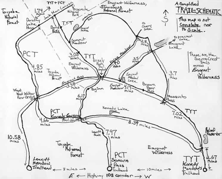
The schematic above is not to scale nor accurate except as a guide to our potential TYT-PCT alternative routes across the Emigrant Wilderness.
It is valuable for revealing some of our potential backpacking loop routes we can hike across the Emigrant Wilderness using bits of the TYT and PCT South of Highway 108.
The Trail Guide South of Highway 108 explores these alternative routes in detail.
Map INDEX North: Ebbetts Pass to Sonora Pass Map INDEX South: Tuolumne to Reds Meadow
|
Toiyabe National Forest TYT-PCT |
||||||
Topo BACKPACKING MAPS Sonora Pass |
||||||
| 7.5 minute USGS Backpacking Maps 1:24 000 |
|
30 minute USGS Backpacking Maps 1:100 000 |
||||
1>Sonora Pass
Toiyabe National Forest
OFF Trails OFF the PCT-TYT
PCT & TYT NEW MAP Trails OFF the PCT-TYT: Kerrick and Rodgers Canyons Trail Junctions into The Grand Canyon of the Tuolumne River
PCT & TYT 4> Bensen Lake NEW MAP Trails OFF the PCT-TYT:
5> Miller Lake
PCT & TYT 6> McCabe Lake
|
Carson Iceberg-Emigrant
Emigrant
Grand Canyon
Hoover Wilderness
North
Northeast 5>Virginia Canyon
|
|||||
| The 7.5 map gives high detail. | The 30 min map gives a bigger picture of the terrain | |||||
ALTERNATIVE ROUTES PCT | ||||||
| Emigrant Wilderness FS Miles-Map |
Emigrant Wilderness Backpacking Loop Schematic |
|||||
PCT |
||||||
| Mokelumne Wilderness Carson Pass to Ebbetts Pass |
Carson Iceberg Wilderness Ebbetts Pass to Sonora Pass |
|||||
| Emigrant-Toiyabe-Yosemite Sonora Pass to Tuolumne Meadows |
||||||
The next maps South: The John Muir Trail |
||||||
The Big View Carson Pass to Bensen Lake 1x2 Topographic |
||||||
MAP
|
||||||
Map INDEX North: Ebbetts Pass to Sonora Pass Map INDEX South: Tuolumne to Reds Meadow
Backpacker ForumsTahoetoWhitney.OrgTW ORG has Backpacker's Trail Forums covering the Sections and Segments of the long distance High Sierra Trails between Lake Tahoe and Mount Whitney, and topics of interest to backpackers everywhere:
Here's a few of my favorite topics: Unidentified Hikers can post up comments in all the Trails and Topics Forums. Registered Members can post up their own pages in the forums. Add your experiences, comments, questions, and pictures. Or write up a page about your adventures and trips South from Highway 108 to Tuolumne Meadows, and our trips into the Hoover and Emigrant Wilderness too, right here: Trail Section
|
Map INDEX North: Ebbetts Pass to Sonora Pass Map INDEX South: Tuolumne to Reds Meadow
Trailhead
Contact
Alex Wierbinski