Killer Sunset at The Sisters near Carson Pass Lake Tahoe to Mount Whitney: Crown Jewel of the Pacific Crest Trail Need a Map? Lost Al near Lost Keys Lake
South Yosemite topo map Merced Lake to Donohue Pass via Voglesang HSC.
Dicks Lake   Lake Aloha
Dicks, and Fontanillis Lakes from Dicks Pass

Merced Lake to Island Pass
Topo Hiking Map

The Golden Triangle Trail Map
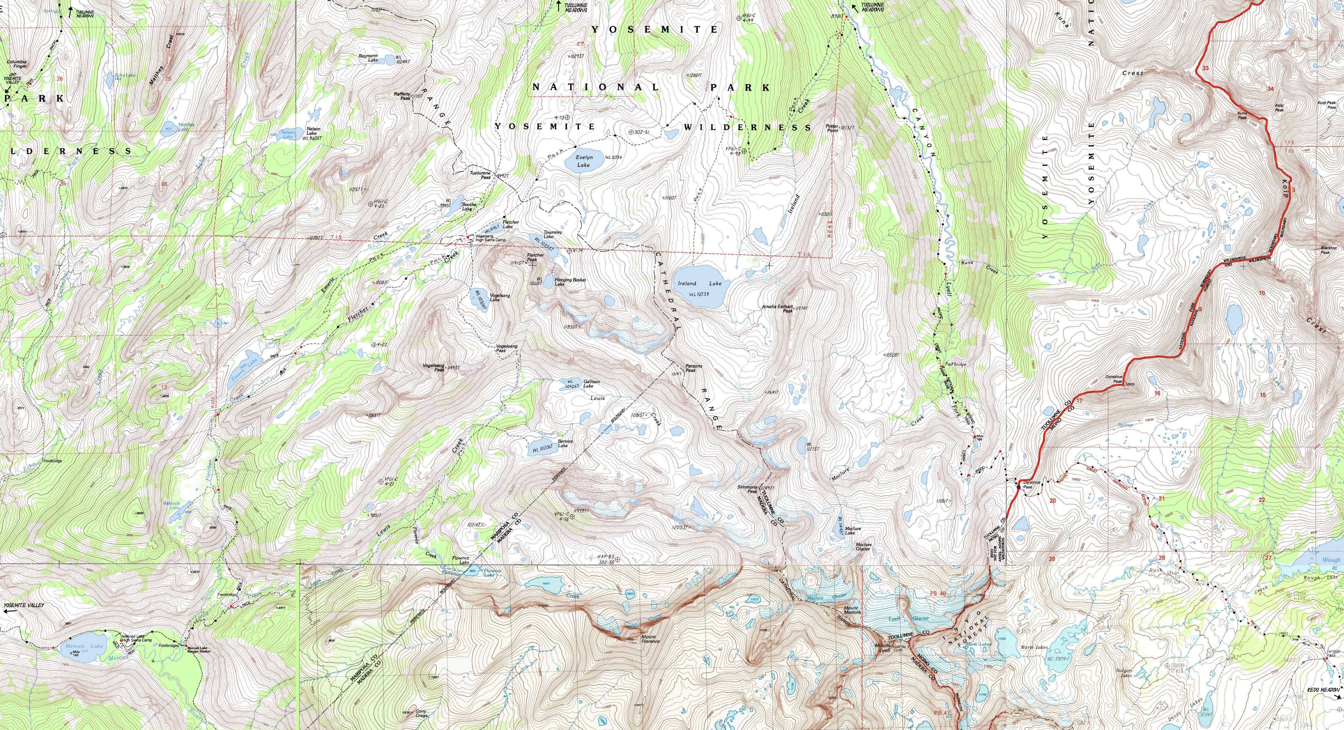
Central Yosemite
from the
John Muir Trail
to the
John Muir Trail

Six
7.5 minute USGS Topographic Backpacking Maps

Aloha Lake under Pyramid Peak from Dicks Pass

Maps Index
JMT
YOSEMITE

Yosemite Valley
to
Island
Pass

via
Merced
Lake

Guide Index
JMT
YOSEMITE

Yosemite Valley
to
Island Pass
via
Merced
Lake

7.5 min
MAP
NORTH

Tuolumne
Meadows

7.5 min
MAP
SOUTH

Donohue
Pass

to
Reds
Meadow

Miles
and
Elevations

NORTH

Tuolumne Meadows
to
Yosemite
Valley

Miles
and
Elevations

SOUTH

Yosemite
Valley

to
Lyell
Canyon

via
Voglesang

Trail Guide PAGE

Cathedral
Lake
to
Tuolumne
Meadows

30 minute
MAP


Central
Yosemite

Click
RED DOTS
for Trail Guide Page

WEATHER

Yosemite

All
High Sierra
Weather

RESUPPLY

Tuolumne
Meadows

Yosemite
Valley

PERMITS


Yosemite
National
Park

Map Information

Out of the Heart of Yosemite into the Ansel Adams Wilderness of the Inyo National Forest

North to Tuolumne Meadows: Tuolumne Meadows Region Backpacking Map
West from Merced Lake:
Merced Lake to Yosemite Valley

Click
Red Dots

  South: Donohue Pass to Reds Meadow

South Yosemite topo hiking map.

North to Tuolumne Meadows: Tuolumne Meadows Region Backpacking Map
West from Merced Lake:
Merced Lake to Yosemite Valley

Click
Red Dots

  South: Donohue Pass to Reds Meadow


Mapology

MAP NOTE
Those squares breaking the USGS maps up into grids are the Universal Transverse Mercator / Military Grid Reference System, otherwise commonly known as UTM.

What's important for our general reference purpose is that each side of a square is 1000 meters, or a Kilometer.

From my point of view that is 1093.6 yards or .62 of a mile.

Diagonal: 1414.22 meters, if my trig is correct.

That converts the diagonal distance into 4,639.8 feet or .88 of a mile.

Map Information Map Symbols

Online and Trail Maps Online Length Conversion


Location Information

Main Features and Location Notes


Mapping, Mileage,
and
National Forest Information


Trail map from Merced Lake to Vogelsang High Sierra Camp.

Topo hiking map covering Babcock Lake, Emeric Lake, Boothe Lake, Fletcher Lake, Evelyn Lake, Ireland Lake.

Cathedral Range Crestline map of Rafferty Peak to Mount Lyell including Vogelsang Peak and Mount Florence.

Northwestern Map
Tenaya Lake, Calif, 1992, 7.5 minute USGS Topographic Map

North Map
Voglesang Peak , Calif, 1994, 7.5 minute USGS Topographic Map

Northeast Map
Koip Peak , Calif, 1994, 7.5 minute USGS Topographic Map

Southwestern Map
Merced Peak , Calif, 1992, 7.5 minute USGS Topographic Map

South Map
Mount Lyell, Calif, 2004, 7.5 minute USGS Topographic Map

Southeastern Map
Mount Ritter, Calif, 1992, 7.5 minute USGS Topographic Map


Compass Offset
True North is 16 degrees 4 seconds West of Magnetic North


scale
1:24 000

Contours
40 feet


Backpacking permitting authority

National Park
Yosemite

Wilderness Area
Yosemite
Physical location
Yosemite
 

North map:                              South map:

Elevations   More Information

Merced Lake
7212 feet

Vogelsang
High Sierra Camp

10,180 feet

Lyell Canyon
8901 feet

Trail Guide, Section:

Trail Guide, Segment:

Google Map:


Map Credit

U.S. Geological Survey, Department of the Interior
The
USGS

USGS MAP LOCATOR

I love the USGS, as you can see from the Tahoe to Whitney Maps.

I also dig the NWS, as you can see from our Weather Page.

We gotta know the terrain under our feet, and the weather in the sky. These are the basics. In that spirit, let's set you up with the USGS maps sufficient to plan and execute your High Sierra Backpacking Trip with a set of custom backpacking maps.

In fact, we can use the USGS to set us up to plan and hike anywhere in the US of A.

Move the Map to the Sierras. Or your favorite backpacking spot in the US of A. Navigate the map to the area you wish to locate maps. Click "Mark Point" in the options to see the USGS map grid of the various scaled maps.

Select the maps that will help you plan and execute your backpacking trip, set up a directory on your computer named for the trip or location of the maps, and begin downloading those suckers.

Open your USGS maps with Adobe Reader.

But first, we have to "unzip" the maps.

I use 7zip.

Custom Maps
Once we get the maps downloaded, unzipped, and running on Adobe Reader we can cut and paste the pieces of the maps we need together, and mark our selected hiking routes to create our own customized maps using MS Paint, Photoshop, or some other image software.

Printing
If we want to print up our maps for field use we need some printer technology and knowledge. I understand Inkjet printers, special inks, and the proper paper are necessary to print up servicable maps.

At least one reader of Tahoe to Whitney has copied and printed out Tahoe to Whitney Maps with success.

Map Information Map Symbols

Online and Trail Maps

Decimal-Degree Conversion Tool

Using TW maps is totally cool for personal and non-profit uses.

Trailhead
Comments
Contact
Alex Wierbinski

top of page

Lake Tahoe to Mount Whitney

Your guide to backpacking the Sierra Crest, including the Tahoe to Yosemite, Pacific Crest, and John Muir Trails
© Lake Tahoe to Mount Whitney: Crown Jewel of the Pacific Crest Trail