The Trails
Current Weather Conditions
Gear
Testing yourself and your gear
Languages
Trail Arts
Trail Skills
Food
Other
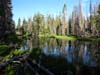
The Tahoe Basin
Desolation Wilderness
Meiss Country Roadless Area
AND THE
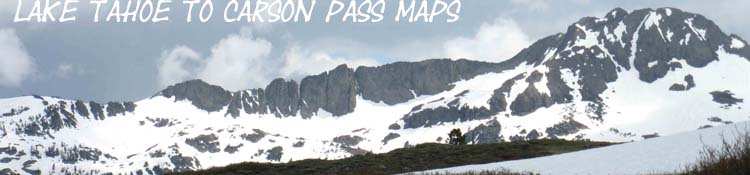
The Carson Pass Management Area
High Sierra Backpacking Maps
Hiking the
Pacific Crest and Tahoe to Yosemite Trails South to Highway 4
Backpacking Map index Backpacking Trail Guide index |
|
|
The Trail Head Options: Your Choice These trailheads are good to start Tahoe to Whitney, Tahoe to Yosemite, or other long backpacking trips South into the High Sierra. And a whole lot more! These trailheads access to the Desolation Wilderness, Meiss Roadless Area, and the Carson Pass Management Unit also offer an endless selection of local short and medium distance backpacking trips in each of these Wilderness, Roadless Area, and Special Units. The maps, guide, miles, and elevations information here will give you the information and tools to break out your own loops and trailhead to trailhead trips along the High Sierra Crest. This guide encourages hikers to add their experiences, comments, or questions about Meeks Bay to Echo Summit and the Trailhead and Trail Options available. Everything adds to our knowledge.
Road Map Google Map locating the See the trail guide |
Topo Hiking Maps |
|
|
|
|
South Upper Truckee Trailhead
|
|
Exiting the Lake Tahoe Basin Two Routes Into |
|
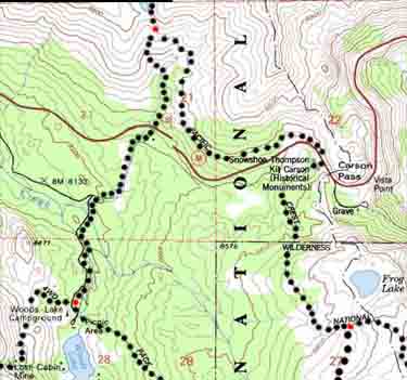
MAPS All of the 30 minute large-scale map's Black Dotted routes are linked to highly detailed 15 minute maps of that area. Local Information Just feet below the South side of the Carson Gap is the first of 3 trail options over the next 3 miles where we can veer off the PCT onto the Southbound TYT. North of Carson Gap the PCT and TYT have been unified since Middle Velma Lake. South of our exit from the Tahoe Basin they follow very different routes. Pacific Crest Trail hikers aim for Ebbetts Pass on Highway 4 through Carson Pass by hiking along the Sierra Crest and its Eastern flank. The Tahoe to Yosemite Trail plunges far down the Western Flank of the Sierra before it climbs through Saint Marys Pass around a mile West of Sonora Pass. Two segments of unmaintained trail between Carson Gap and Saint Marys Pass make the TYT very interesting and challenging. A review of the maps of both of these routes reveals the tremendous difference in terrain and trail between these two very different routes. The links to guide pages from the maps brings us to images, videos, and text carefully describing both of these trails, so we can decide which is better suited for our skills, capacities, and expectations.
2 Route Option Discussions The Tahoe to Yosemite Trail Info I The Tahoe to Yosemite Trail Info II
|
Topo Hiking Maps: PCT-TYT Split |
Southbound Decision Do we hike the Pacific Crest Trail or the Tahoe to Yosemite Trail route South from the Carson Gap? Hummm. The trail guide index, the basics of the TYT, and the maps below help us figure out the best route to fulfill our expectations, goals, and capacities. We can hike the other route next time. Carson Pass Region Topo Hiking Map BIG |
|
Topo Hiking Maps |
|
Pacific Crest Trail Trail Section Map PCT Route Hiking Map
|
|
Tahoe to Yosemite Trail Trail Section Map TYT Route Backpacking Map
|
|
Three Links |
|
South on the Tahoe to Yosemite Trail There are three trail options breaking off to Round Top Lake hiking South from the Carson Gap on the Tahoe to Yosemite Trail route. All three are detailed on the Carson Pass Region Map. Two of them are unmarked junctions just South of the Carson Gap. Pacific Crest Trail hikers stay on the main trail to Carson Pass. A miles past Carson Pass the marked trail to Winnemucca Lake accesses our TYT route to Round Top Lake. Your two choices South of the Carson Gap are simple: Veer Left, through these two unmarked trail junctions to follow the Pacific Crest Trail South to Ebbetts Pass via Carson Pass. Veer Right, to follow the Tahoe to Yosemite Trail route to Lake Alpine over Round Top and The Sisters. We can hike up to Round Top via Winnemucca Lake, Lost Cabin Mine, or the Footbridge routes. The Lost Cabin and Footbridge routes hike around different sides of Woods Lake while the Winnemucca Lake route comes to Round Top from the East. |
|
Wilderness Desolation Wilderness The three hiking areas covered by these maps are very different, for a number of reasons. Desolation Wilderness is very popular. Because of this fact we are going to have to make sure we can get the start date we want for our Tahoe to Yosemite Trail hike by inquiring with the Lake Tahoe Basin Management Unit, known as the LTBMU. Meiss Country Roadless Area Meiss Country Roadless Area does not require permits for local hiking, though that does not help us. Starting out of South Upper Truckee Trailhead for Tuolumne Meadows requires that we draw a permit to authorize the rest of our trip South of Meiss Country. Even though a backpacking permit is not required, Carson Pass Management Area The Carson Pass Management Area is more like Desolation than Meiss, at least as far as permits and people are concerned. The CPMA is very busy and restricts permits, as does the much larger Desolation Wilderness.
This special area requires special permits only obtainable from the Carson Pass Cabin, or the Almador Ranger District of the El Dorado National Forest, if the Carson Cabin is closed. 1x2 Carson Gap to Highway 4 |
|
| More Information | |
High Sierra topo Hiking Maps
South
Carson Pass to Ebbetts Pass
| Map Index | Trailhead |
Contact
Alex Wierbinski
Lake Tahoe to Mount Whitney
Your Guide to Backpacking the Sierra Crest on the Tahoe to Yosemite, the Pacific Crest, and the John Muir Trails