

High Sierra
Backpacking
Trail Guide
Forums
Sierra
Weather
WeatherNotes Northern
Sierra Weather
Gear
Backpacking
10 Trail Junctions
from
Lake Aloha to Echo Lake Trailhead
Hiking
South through the Desolation Wilderness on The Tahoe to Yosemite and Pacific Crest Trails
Languages
Trail Skills
Mountain
Safety
Food
Planning
Trail Arts
More
Information
Social
Trail |
North |
South Upper Echo Lake |
Trail Miles & Elevations |
Trail Miles & Elevations Index |
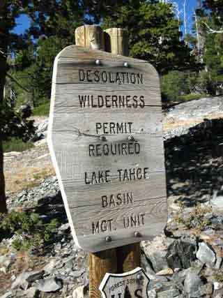
Lake Tahoe Basin PERMITS |
Local Weather All Sierra Weather |
All Wilderness PERMITS |
all pages |
A Mess of Trail Junctions
just
South of Lake Aloha
to
Upper Echo Lake
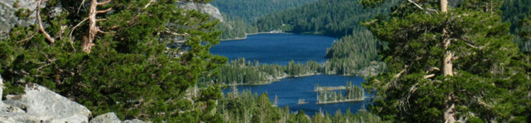
Many Fine Local Destinations Though this 2.9 mile segment from the Northern Lake of the Woods trail junction South down to the Desolation Wilderness Boundary there is a whole gaggle of trail junctions within this short distance, it's really not too confusing for the through hiker. This series of trail junctions represents a mess of local short-distance backpacking opportunities. For a long distance backpacker, it's like running the gauntlet. We Southbound hikers on the Tahoe to Yosemite, Pacific Crest, and Tahoe Rim Trails just keep a straight line from Northwest to Southeast through them all, staying on the main North-South line of the Combined TYT, PCT, and TRT.
Meeks Bay to Echo Summit
The problem with all of these trail junctions along this section of trail from Aloha Lake to the Desolation Wilderness boundary stems from developing too many cutoffs before and after each main trail junction. It's the trail "Y" problem, magnified by extremely high backpacker traffic. Hikers approaching a trail junction tend to cut off the main trail to intersect with their next trail diagonally, rather than hiking to the junction and then making their turn. This practice has created the series of "before and after" trails bracketing each main trail junction. The good thing is that the main North-South route through here, shared by the Tahoe to Yosemite, Tahoe Rim, and the Pacific Crest Trails maintain the same Northwest to Southeast line making it pretty easy to figure out and stay on the main trail while running through this gauntlet of trail junctions. These junctions are another sign of the the Desolation Wilderness' popularity and overuse. Local backpackers will find that a little map study will go a long ways towards figuring out the best way to and from local backpacking destinations at the many stunning lakes that are just a bit offset from our Tahoe to Yosemite Trail route along this 2.9 mile segment of the trail. I count six. Lake of the Woods, Lake Lucille and Margery, with Tamarack, Cagwin and Ralston Lakes just nestled within the Eastern edge of the Desolation Wilderness Boundary, all offering excellent hikes to them, campsites around them, and beautiful terrain for scrambling and hikes along this short segment of trail. This section of trail is not too far from the main Desolation Wilderness through Lower Echo Lake. As we hike South towards our departure from the Desolation Wilderness we will also encounter trails to the North and South taking us out of Desolation towards Lake Tahoe and Highway 50. To the North the trail to Lilly Lake, just off the South shore of Fallen Leaf Lake. To the South the trail to Highway 50 at Sayles Flat. |
The Numbers
| Hiking South of Lake Aloha to Lower Echo Lake Trailhead Desolation Wilderness |
Desolation WildernessTrail junctions South of Lake Aloha
You will first encounter the Lake of the Woods trail junction, then 9 more junctions in quick succession. The reason for so many trail heads is that each destination has a North and South junction along our trail, doubling the trail junctions.
Lake of the Woods Trail Junction Elevation Mileage note: ALWAYS Double-Check your (and my) mileages, and work up your own figures. Trail distances are constantly changing as the trails are being regularly rerouted by man and nature.
Meeks Bay to Echo Summit
|
Trail Junction #1
Lake of the Woods cutting Right (SW)
 |
| Lake of the Woods Southbound hikers branch off to the Right for the 1.21 mile hike to the Southeast to Lake of the Woods. This junction would only be used by Southbound hikers to Lake of the Woods, and Northbound hikers from Lake of the Woods to Lake Aloha. |
Trail Junction #2
Lake Lucille and Lake Margery, cutting Left (E)
and
trail Right (SW)
which links up with the trail between the
South end of Lake Aloha and Lake of the Woods.
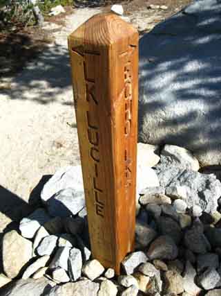 |
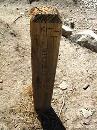
Lake Lucille and Lake Margery to the Southbound hiker's Left, North by the compass. The trail up to Lake Lucille is .4 of a mile. This trail loops back to the 3rd trail junction, shown below. passing by Lake Margery on its short quarter mile return to the Tahoe to Yosemite Trail. The total length of this short loop up to Lake Lucille and back to the next trail junction along our Tahoe to Yosemite Trail route is .63 of a mile. Note |
Trail Junction #3
Lake of the Woods, cutting Right, (S)
trail to Lakes Margery and Lucille to the Left, (N).
 |
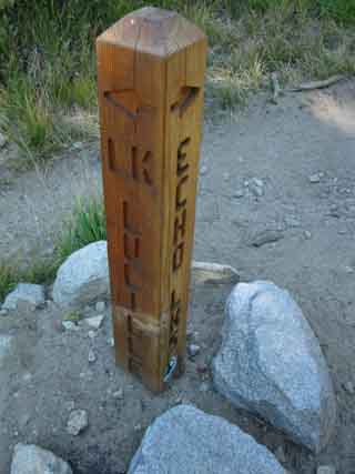 |
Lake of the Woods is .39 of a mile to our South, the Southbound hiker's Right. This is where the trail to Lake Lucille and Margery from the 2nd trail junction rejoins our Tahoe to Yosemite Trail after its .63 of a mile loop up to and past the lakes. |
|
North: Lake Aloha South: Echo Lake
Trail Junction #4
Lake of the Woods, cutting Right (S)
 |
| Lake of the Woods |
Trail Junction #5
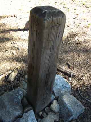
Trail to Mount Ralston, cutting Right (S)
This is the first and most direct trail to Mount Ralston that Southbound hikers encounter. |
Trail Junction #6
Trail to Ralston Peak and down to Sayles Flat on Highway 50 above Twin Bridges
Passes junction West to
Lake of the Woods. Trail branches off to the Southbound Hiker's Right (S)
This is the Northbound Hiker's first opportunity to turn South towards Ralston Peak, or to the Lake of the Woods.
|
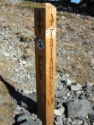
Trail Junction #7
Triangle and Lost Lakes, cutting Left (NE)
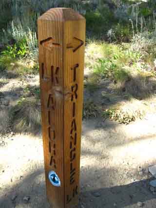 |
Triangle and Lost Lakes. Left Turn: To Triangle Lake and on to Lilly Lake. This Left would also be the Southbound backpacker's route over to Lilly Lake, near the South shore of Fallen Leaf Lake. .76 of a mile to the Northeast (Left) from our current position we come to a four-way trail junction. .33 of a mile to the Left, the Northwest, from this four-way trail junction lays Triangle Lake. That puts the distance from this junction to Triangle Lake 1.09 miles. Hiking straight through the Triangle and Lost Lakes junction, to the Northeast, we hike to the trailhead on the road to Lilly Lake, located off the Southwest shore of Fallen Leaf Lake. |
Trail Junction #8
Tamarack, Cagwin and Ralston Lakes, cutting Right (S)
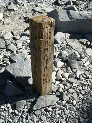 |
Tamarack, Cagwin and Ralston Lakes. Tamarack Lake is located a tenth of a mile South of this trail junction. .31 of a mile South of Tamarack Lake the trail leads down to a small loop of trail accessing Cagwin and Ralston Lakes. |
Desolation Wilderness Boundary
Trail Junction #9
Triangle and Lost Lakes,
cutting Left (N)
AND
Lilly Lake beyond, off the Southwestern shore of Fallen Leaf Lake
 |
 |
||
Triangle and Lost Lakes to the Northwest from the Desolation Wilderness Boundary. This would be our last way North towards Trailheads accessible from the Southwest shore of Lake Tahoe for Southbound backpackers and the first for Northbound backpackers out of the Lower Echo Lake Trailhead. On our way South from Meeks Bay we have passed the trails East out to the Eagle Falls and Bayview Trailheads. South of Dicks Pass we found the junctions leading to trails North over Mount Tallac and down to Glen Alpine along the Western and Southern shores of Fallen Leaf Lake. Now we are encountering the last junction North towards Lake Tahoe before we finish our hike across Desolation Wilderness. Well, we are exiting the wilderness here, though we still have 5.23 miles before we hike out of the trailhead at Echo Chalet. The trail from here up to Triangle and Lost Lakes bends to the Northwest to a four-way trail junction .38 of a mile beyond our position here at the Desolation Wilderness Boundary. Triangle and Lost Lakes are another .33 of a mile to the Northwest straight through this trail junction. This puts Lost and Triangle Lakes .71 miles to the Northwest of our current position at the junction at the Desolation Wilderness Boundary. The trail junction located between our position here at the Wilderness Boundary and Lost Lake also turns to both the Southwest and Northeast, as well as straight through to the Northwest to Triangle and Lost Lakes. Turning Northeast, to our Right from that trail junction puts us on the trail to the trailhead at Lilly Lake, located off the Southwest shore of Fallen Leaf Lake. The distance from the four-way trail junction between the Desolation Wilderness Boundary and Lost and Triangle Lakes to the Lilly Lake Trailhead is 2.11 miles, added to the .38 to that junction from here makes a total of 2.49 miles.
Meeks Bay to Echo Summit
|
|||
Trail Junction #10
Boat Dock, Water Taxi, cutting Right, down to the lakeshore.
 |
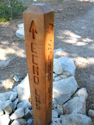
Boat Dock, Water Taxi. Northwest shore of Upper Echo Lake. Boat Taxi rides from Echo Chalet Marina during Summer Season. Less than a tenth of a mile Southeast off the Tahoe to Yosemite Trail. |
North: Lake Aloha South: Echo Lake
The Trail Junctions between Lake Aloha and Echo LakeFrom a Northbound Perspective |
|||
Northbound out of Echo Lake Trailhead
If you want to figure out how plan a Northbound Desolation Wilderness trip out of Echo Lake Trailhead, this series of trail junctions gives the Northbound backpacker access to the width of Southern Desolation Wilderness. There are many choices for short trips for beginner or short-distance backpackers within easy hiking of the trailhead. This is one reason why the Desolation Wilderness is so very crowded during mid-Summer. And the fact that you can drive right up to the Echo Lake Trailhead, drop your gear, and then park your car in the upper parking lot. If there's a space! Easy access to such deep beauty brings in a lot of people for short trips out of Echo Lake.
For example, the first main trails branching to the East, or the Northbound backer's Right while heading South out of Echo Lake, all head around Keith's Dome to Triangle and Lost Lakes, and then on over to Fallen Leaf Lake. A nice little overnight loop for the beginner, or you can head over to Fallen Leaf Lake. It's about 6.5 to 7 miles from the Echo Lake trailhead to the shore of Fallen Leaf Lake. Many trails branch to the Northbound backpacker's Left, or West. A whole series of trail junctions lead West to Tamarack Lake and Lake of the Woods, and one junction leads over Mount Ralston to Highway 50. I talked to a backpacking couple who scrambled up the Pyramid Creek from Twin Bridges on Highway 50 into the Desolation Valley in the shadow of Pyramid Peak in the Summer of 2009. They were tough kids, and they rated it a very tough scramble. Backpackers seeking more of a challenge on the trails can continue Northbound straight through this maze of trail junctions towards Lake Aloha, and continue North for 22.5 miles following the Tahoe to Yosemite route through the heart of the Desolation Wilderness to the Meeks Bay trailhead. There are also a number of trails out to various West Lake Tahoe trailhead closer to Echo Lake than Meeks Bay, where this Tahoe to Whitney trail guide begins the classic Tahoe to Yosemite route. Although I'm trying to give you an idea of the range of routes and trips you can craft backpacking out of the Echo Lake trailhead, my advice to you is to completely avoid the Echo Lake trailhead during the high Summer backpacking season, especially during weekends. It is just too overused. If you must enter the Desolation Wilderness during mid-Summer, I suggest you plan a trip from one of the trailhead along the Western Shore of Lake Tahoe. They too are busy, but at a lower degree of insanity than Echo Lake trailhead during the Summer. Great loops can be crafted into the Northern section of Desolation through the Meeks Bay trailhead, as well as from the Emerald Bay, the Cascade Lake, and Fallen Leaf Lake trail heads.
The Long-Distance backpacker heading South will virtually ignore these trail junctions as distractions from the goal of making the daily mileage.
Trail Map
Trail Map
South |
Backpacking Trail Guide
North
|
 |
Backpacking Trail Guide
South
|
Backpacker Forum Post it on Above we come to the Front Page of the High Backpacking Trails and Topics Forums. Below we break the forums down into categories:
Maze of Trails South of Lake Aloha, Desolation Wilderness Add your experiences, comments, or pictures about this maze of trail junctions: Section
|
North: Lake Aloha South: Echo Lake
Trailhead
Contact
Alex Wierbinski

Backpacking Lake Tahoe to Mount Whitney
Your guide to the High Sierra Crest, including the Tahoe to Yosemite, Pacific Crest, and John Muir Trails
