


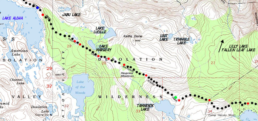
South side of Aloha Lake to the North side of Echo Lake
Hiking the Tahoe to Yosemite and Pacific Crest Trails through Desolation Wilderness
Desolation Wilderness 7.5 minute USGS Backpacking Map

Map Index |
North |
full |
South |
30 min MAP page |
Click map points for links to Trail Guide Page | Trail Guide Junctions South of Lake Aloha |
all maps | all pages | miles and elevations | map info |
3.51 miles from the South side of Lake Aloha to Boat Taxi Dock on Upper Echo Lake
North: Lake Aloha Miles and Elevations Click Red Dots South: Haypress Meadow to Highway 50
|
North: Lake Aloha South: Haypress Meadow to Highway 50
next MAP page: full Echo Lake 7.5 Map
Desolation Wilderness Mapping Information, miles, and Elevations |
|
MileagesLake of the Woods trail junction at South end of Aloha Lake to Echo Lake trail head: 6.13 miles also see Lake Aloha to Echo Lake trail head 30 min map info Meeks Bay to Echo Summit Meeks Bay trail head to Lake Genevieve: 4.39 miles Lake Genevieve to Middle Velma Lake: 7.93 miles Middle Velma to N. side, Aloha Lake: 8.84 miles North side of Aloha Lake to Echo Lake trail head: 7.55 miles Echo Lake trail head to Echo Summit Trail head: 2 miles Totals Meeks Bay trail head to Echo Lake trailhead: 28.71 miles Meeks Bay trail head to Echo Summit trailhead: 30.71 miles Lake Tahoe to Lake Alpine Trail Guide Index Meeks Bay trail head Download Free USGS Topo MapsINSTRUCTIONS 1>Locate the position you need a map for on the google map. 2>CLICK the MARK POINTS mode. 3>Select the size of MAP FOOTPRINTS you wish to see. 4>CLICK the Map Footprint you want to down load. This will leave a red marker on that map footprint. 5>CLICK the red marker, and the maps available for you to download will appear. 6>Select and download the map you need. NOTE: These are "GEO Maps" that load in Adobe Reader with many cool functions. If you want to manipulate and print custom sections, you must first load the map into MS Paint before it can be manipulated in PhotoShop. |
USGS Map InformationMap Name: Echo Lake Calif.-Nev., 1992, 7.5 minute Topographic
Compass Offset: Magnetic North is 18 degrees, 34 minutes East of True North
scale: 1:24 000 Contours: 40 feet
Backpacking Permitting Authority Lake Tahoe Basin Management Unit TahoeWhitney: Contact Information Feds: Lake Tahoe Basin Management Unit
National Forest LTBMU Wilderness Area: Desolation Wilderness, TahoeWhitney Desolation Wilderness, the feds.
Meeks Bay trail head
Physical location Between Highway 89 and Highway 50 in the Desolation Wilderness approaching Highway 50. |
North: Lake Aloha South: Echo Lake 2
| Elevations | More Information | ||
Lake Aloha: 8120 feet Echo Lake Trailhead: 7414 feet Elevation change: -706 |
Trail Guide, Section: Meeks Bay to The Carson Gap Trail Guide page: Meeks Bay Trailhead Google Map: All Lake Tahoe trailheads |
||
Map Credit |
U.S. Geological Survey, Department of the Interior The USGS Get this topo from the Use search term "Meeks Bay," and "Address," as search type to locate this USGS map. USGS Topographic Map Information |
This trail started at the