High Sierra
Backpacking
Trail Guide
Forums
Sierra
Weather
WeatherNotes Northern
Sierra Weather
Gear
Trail
Segment
Donohue Pass to Island Pass
&
The
Rush Creek Drainage
Combined
JMT & PCT
Trail
Section
Tuolumne Meadows to Reds Meadow
BACKPACKING
ANSEL ADAMS WILDERNESS
INYO NATIONAL FOREST
Hiking
The
John Muir Trail
South
to
Reds & Agnew Meadow Trailheads
Languages
Trail Skills
Mountain
Safety
Food
Planning
Trail Arts
More
Information
Social
| Trail Guide INDEX JMT-PCT Tuolumne Meadows to Reds Meadow |
Trail Guide NORTH JMT-PCT Lyell Canyon up to Donohue Pass |
Trail Guide SOUTH WEST JMT Island Pass to 1000 Is Lake |
Trail Guide SOUTH EAST PCT East Route to Agnew Meadow |
7.5 Topo Map Donohue Pass to Reds Meadows MAP |
30 min |
Tuolumne Meadows |
TOPO MAP INDEX Tuolumne Meadows to Reds Meadow |
Resupply South |
Forest & Parks Permits Toiyabe & Yosemite & Inyo |
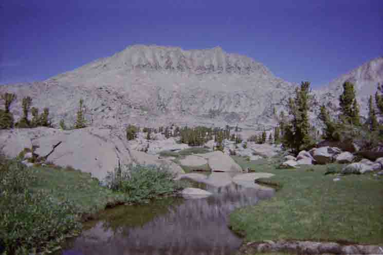
11,040
feet of elevation
Big Pond
 |
||||
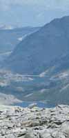
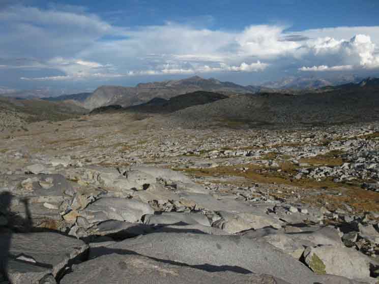
Climbing South along the combined route of the John Muir and Pacific Crest Trails to the pond on the North edge of the great flat constituting Donohue Pass.
Hiking Maps
|
Backpacking The Southern Boundary of Yosemite,
Map Donohue Pass to Reds Meadow Hiking Map Miles & Elevations
Donohue Pass PCT-JMT ...to Marie Lake trail junction ...to Waugh-June Lake trail junction ...to Davis Lakes trail junction ...to Island Pass
...to 1000 Island Lake Trail Junction
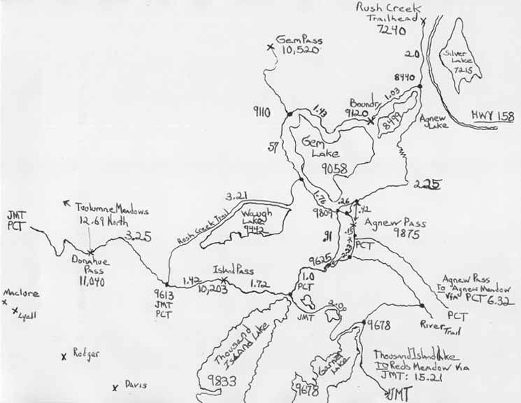
Local We have a number of local options tying Agnew and Reds Meadows together in big loops around the headwaters of the San Joaquin. We can start North from Agnew Meadows on the PCT, and turn South at the triple trail junction at Thousand Island Lake to return via the Southbound John Muir Trail. Or visa-versa. We also have fantastic local backpacking loops South out of Reds Meadow & Mammoth Pass, but we will address those later, as we begin hiking South from Reds. Here, the "local" long distance backpacker has entrance and exit options to our North in Yosemite, to our East through Rush Creek from June Lake, and to our South using Agnew and Reds Meadows. Donohue Pass to Reds Meadow Hiking Map
Maps and Miles Ansel Adams Wilderness Three Main Routes South of
More East of Donohue Pass
JUNE LAKE LOOPS Here we have options to put together loops coming out of and back to the Rush Creek Trailhead through Agnew and Island Passes.
Regional Topo Map of the Terrain Below |
Detailed Map of the Above
From the
Hiking NORTH Northbound we have two standard targets: Tuolumne Meadows along the Northbound routes of the combined JMT & PCT, or we can cross the Cathedral Range via Ireland Creek out of Lyell Canyon for the walk down to Yosemite Valley.
NORTHBOUND
Miles
BOTH South Yosemite & North Ansel Adams Wilderness
Backpacker Resources
Lakg the Tahoe to Yosemite Trail. |
||||||||||||||||||||||||||||||||||||
Donohue Pass
Crossing Long Distance Backpacker Alternative Routes On the other hand, Yosemite Valley may be our destination hiking North from Donohue Pass, starting out of June Lake or Reds Meadow. We may be hiking South from Tuolumne Meadows along the standard route of the combined John Muir and Pacific Crest Trails, looking to our next resupply spot at Reds Meadow and/or Agnew Meadows, respectively, and maybe even a nice little stop-over in Mammoth Lakes for a couple of nights of extended rest, resupply, and recharge. Or we may be following the JMT-PCT routes North to Tuolumne Meadows on our itinerary. In any case, our long distance backpacking objectives typically requires we cross Donohue Pass. Why Donohue Pass?
South End of Yosemite
Yosemite Donohue Pass Exit Quota
Busy Place
The Top Our 7.5 map of South Yosemite best shows the location of these lakes to the South of Donohue Pass.
Off the Trail These lakes were described on the
South End of Yosemite If we are not camping at or near Donohue Pass we will likely hike down to the top of the finger of lush, verdant green terrain reaching up to just beyond the top of the treeline along Rush Creek, to find a plush site along its scenic moss-covered banks, rock formations, at the top of the furtherst reach of the whitebarks, for this night's campsite.
Crossing over Donohue Pass, the character of the grandure surrounding us changes. SECTION GOALS Southbound JMT Scrambling-Exploring Zone Top of Rush Creek Island Pass to Lake Catherine "I arrived, I observed, I scrambled." Since we've spent the time and energy to hike all the way down to Rush Creek and Thousand Island Lake from Lake Tahoe, we're damn sure going to take the time to explore and absorbe as much of this remarkable terrain as we can, every time we hike through. Our previous section of trail between resupply points to the North took us across the 73.71 miles from Sonora Pass to Tuolumne Meadows. This current section of the John Muir Trail spans 34.25 miles from Tuolumne Meadows South to Reds Meadow only crosses half that distance. This short section gives us a good chance to easily pack a couple of extra days' food to camp at custom sites, to take a couple of days off to do some serious scrambling. Each of these next upcoming Southbound segments of our trail from Donohue Pass to Reds Meadow all have exceptionally beautiful unique configurations of terrain and ecology that we will only be able to properly explore by taking that necessary time, by packing that necessary extra food, and writing a couple of days off through this section into our plans, for deeper explorations. Those are my section goals through these upcoming segments of our trails from Donohue Pass to Reds Meadow.
Donohue Pass
Maps & Miles
Map North
30 min Map
Donohue Pass SOUTH
12.69 miles 12.08 miles 10.62 miles 6.45 miles 3.57 miles
Donohue Pass SOUTH
2.52 miles 3.25 miles 3.68 miles 4.67 miles
6.39 miles
21.56 miles
|
 |
||
Southern Yosemite Boundary into the Ansel Adams Wilderness.
|
Trail
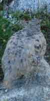
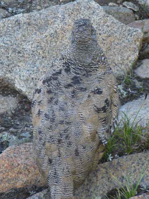
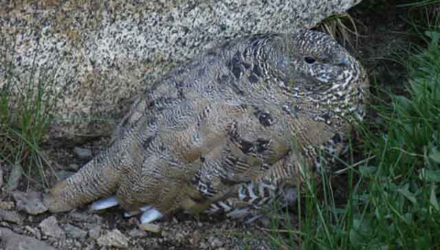
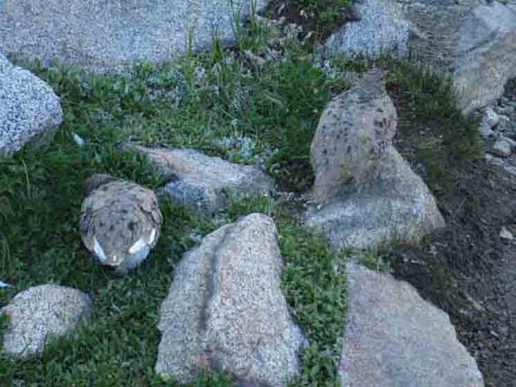
Breaktime Donohue Pass Sometimes I push down to the top of the quite special verdant green swath of moss and meadows running up into the rock terrain under the South Flank of Donohue Pass along Rush Creek. I figure its less than a mile down to the top of this lushness, where it ends at the local treeline. Descending less that 2 miles puts us into the thick of it, with all sorts of custom, awesome campsites to choose from. Below this narrow zone of lushness the temps warm, the moss retreats, and the hearty stands of whitebarks on granite are supplanted by thicking lodgepoles and mixed forests. So, I'm going to take a break at the top of Donohue Pass, even if I am only proceeding over the Pass and over to the lakes under the crestline, or if I'm continuing a couple of miles further South from Donohue Pass to camp along the top of Rush Creek's treeline. Donohue Pass is a significant high point, so I am going to kick back, look around, and enjoy it for a while in any scenario. Plus, I almost always meet some critters up here, mostly birds screwing around in the rocks. The grass growing around this vast talus field supports a big enough population of insects supporting a population of mountain chickens that I almost always have an encounter, an encounter of the mountain chicken type, every time I hike through.
I was sweet-talking, and these normally tweaky birds were fluffing-up, Well, no, not from me. I don't feed the critters. Not food. Seeing that hesitation allowed me to fill it with good sounds and vibes, which they interpreted properly as consisting of pleasure, rather than pain, which stopped their rush to get away from me. The bird above "fluffed up," and narrowed its eyes enjoying the love. As the human we are the self-reflective ones, "setting the stage," so to speak. Duces Cityiodits have been training these birds to solicit food by feeding them, which makes them human-dependent, but I NEVER feed the critters. Control the Interaction, Bird Identification, News, & Research They were a good audience for this particular lecture. Other "Animal Lectures" I give every now and again are not as well-recieved. I am thinking about those damn human-acclimated Yosemite Bears that the Park Service pulls out of Yosemite Valley, and drop up here. Those bears just don't listen. They ignore all good manners even as we lecture them most forcefully about our "no bears in camp" policy with tongue and rock. The Marmots, on the other hand, pretend they do not hear us, but they can, and I know the Marmots know exactly what I'm saying, but are ignoring me as they make their own, independent plans. The acclimated Yosemite bears ignore both tongue and rock, continuing their quest to steal our food as both our words and rocks bounce off their fortress-like bodies. Marmots will just kick back from a safe distance, ignoring everything we are telling them, while they are watching us and thinking about how far we will have to wander from camp before they will come in to check it out. I know what you're thinking, Marmot!
|
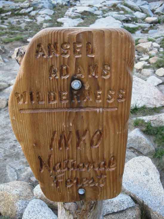
Southbound into Ansel Adams Wilderness
Donohue Pass
|
||
The sign marking our passage South across Donohue Pass into the North end of Ansel Adams Wilderness.
|
Considering At, or Just South Flank of Donohue Pass Before continuing South we are going to spend the night up here. I figure I'm going to find my way almost directly South (by the compass) of Donohue Pass to the two little lakes wedged in under the crestline. The thing is, it's pretty rough terrain pushing South from the Crestline at Donohue Pass, or from just below it on the South Flank. I have it in my mind's eye that it's best to descend a little ways along the Southbound JMT before cutting South off the trail. It's harder to get over from the top. But, don't descend too far. We want to traverse over to the lakes, not climb! Our other options for camping up here are in or near the Upper Basin of the Tuolumne River, which lay .95 of a mile North along the combined PCT-TYT, down the West Flank from Donohue Pass, shown on the trail guide page to the North. Our other option for camping is just a short ways, about .83 of a mile to our South down from Donohue Pass along the JMT-PCT, at the fine sites that begin to appear at the top of the finger of green moss and whitebark pines reaching up along Rush Creek to the treeline. Those sites at the top of, and just below Rush Creek's treeline, are located within a unique environment that's worth checking out and exploring, even if you are not going to camp there. Have one of the day's long lunches at the top of Rush Creek, if you can't camp there.
TOP OF THE TREELINE I always expect to see a hobbit chasing a rabbit through here...
Maps & Miles
Map North
30 min Map
|
| OFF THE TRAIL to the Two Lakes |
View Northeast
Looking Down at Donohue Pass
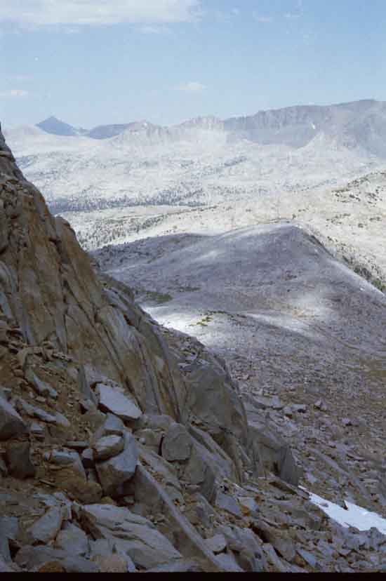 |
Up against the Wall; We've hiked over Donohue Pass, then scanned the terrain to find the best route cutting West off the John Muir Trail over to the two blue lakes nestled up under where the Sierra Crestline bends South. After making camp we scramble further West and up to get this overview of Donohue Pass below, the granite mound rising to its East, and the foot of Donohue Peak rising out of the upper-Right edge of the image.
|
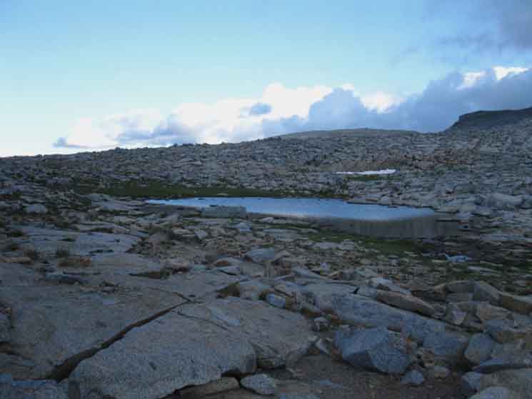
One of Donohue Pass's Lakes
 |
||
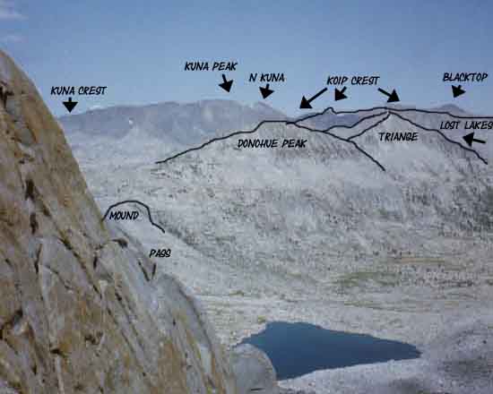
Below us stretching out to the Northeast beyond these fine hidden lakes is Donohue Pass, Mount Dana is the great dark pyramid in the distant Left, and the Koip Crest runs South across most of the top of the image.
|
| Transitions
Crossing The character of the grandure changes. |
View South from Donohue Pass
 |
||
As we begin making our way South off the Donohue Pass Flat we can begin to see Ritter and Banner peaking over the ridge to our direct South.
|
View East
Middle San J to the South,
Rush Creek to East Below
 |
||
Rush Creek Watershed below South Flank of Donohue Pass, veering off to the Left. The middle Fork of the San Joaquine River runs Northwest to Southeast in a majestic two-tone canyon below San Joaquin Mountain, which is the predominant peak in Distant Center.
|
Mammoth Mountain to Our Southeast
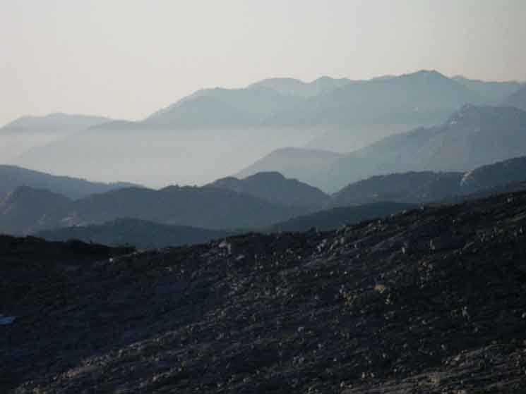 |
||
Hiking down in early morning provides the contrast to pick up the detail of the ridges, peaks, and valleys looking to our Southeast at Mammoth Mountain
|
View South
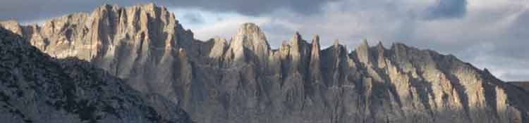
Minarets along the Sierra Crestline to our South.
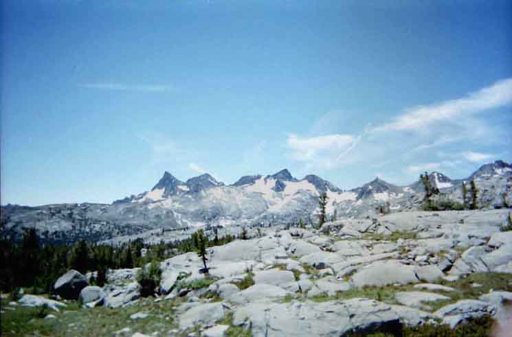 |
||||||
Banner and Ritter from Left to Right in the center distance, with Mount Davis to their "Right," but much closer than Banner and Ritter.
Central & South Yosemite Hiking Map
Ansel Adams Wilderness
Miles and Elevations
v
|
South
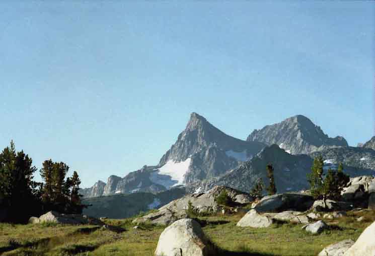
Banner Peak and Mount Ritter
 |
||
The Sierra Crestline to our South, wrapping around Davis Lakes, before it bends South across Banner Peak and Mount Ritter.
|
Trail
v
|
View North
Donohue Peak
 |
||
Looking back the Way we Came. View North of Donohue Peak from top of the strip of green running along to the top of Rush Creek. Donohue Pass is to the Left of Donohue Peak.
|
East
Waugh Lake
 |
||||
v
|
Schematic Trail Map
Rush Creek Trail
OPTIONS
|
||||
Above find the main routes leading us into or out of the Northernmost segment of the Ansel Adams Wilderness wrapping around the Southeastern edge of Yosemite. To our East we have road access to Highway 158, the June Lake Loop, via the Rush Creek Trail. These routes offer quick, but steep, access to the PCT-JMT from June Lake, and a number of loops and trips ideal for local backpackers. This direct route down to June Lake would only be benefical to wounded Long Distance Backpackers looking for the easiest way off the trail. To the South we have three routes bringing us to "civilization," either the route of the John Muir Trail along the granite Western Wall of the headwaters canyon rising above the headwaters canyon of the Middle Fork of the San Joaquin. Or, we can hike the PCT route on the other, the Eastern wall of the canyon. We can hike East from the trail junction at Thousand Island Lake to wrap around under Agnew Pass, to follow the PCT onto the volcanic terrain making up the Eastern Wall of the Canyon, leading to Agnew Meadow. On the way East following the PCT to the East wall we find the trail leading down the center of the canyon into the bucolic forest, meadows, and soft soils of the River Trail, following the route of the Middle San Joaquin between the two much more famous trails. SouthboundHiking MAPS
Northbound Central Yosemite Hiking Map
Page Index |
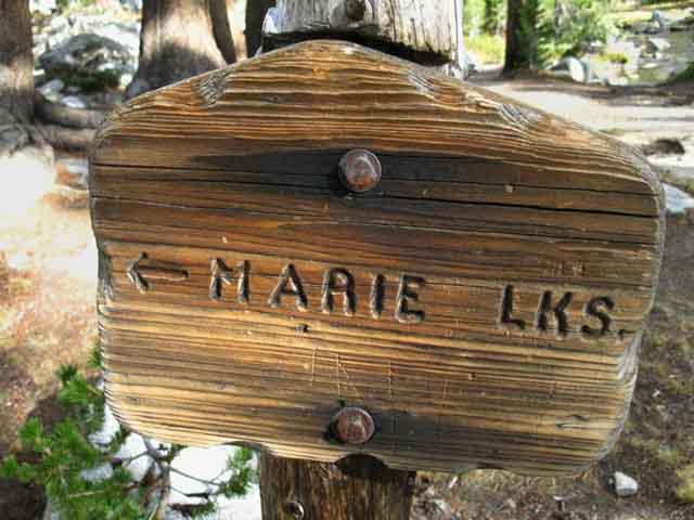
Marie Lakes
Trail Junction
SPUR TRAIL
WEST
Spur Trail
Climbing
to
Marie Lakes
| Marie Lakes Trail Junction along the John Muir Trail 10,072 feet of elevation
SIDE ROUTE
1.57 MILES WEST Marie Lake end of trail 10,856 ft
Island Pass
Maps & Miles
Miles & Elevations
30 min Map
Island Pass
SOUTH 15.21 miles 2.52 miles
Marie Lakes Trail Junction
South
2.15 miles 3.87 miles Thousand Island Lake trail junction John Muir Trail 4.39 miles 4.74 miles 5.96 miles
16.89 miles
|
Trail
v
|
Trail
Trail
v
|
Trail
v
|
Trail
v
|
Trail
v
|
Trail
| Trail Junction to Waugh, Gem, Silver & June Lakes along the John Muir Trail 9613 feet of elevation
SIDE ROUTE
Island Pass
Maps & Miles
30 min Map
Island Pass
SOUTH (NOT DONE) OF XX.36 miles XX.76 miles
Island Pass
Down the John Muir Trail
X.72 miles X.24 miles X.59 miles X.81 miles
16.89 miles
|
Trail
v
|
Trail
v
|
Trail
v
|
Trail
v
|
Trail
| Trail Junction to Davis Lakes along the John Muir Trail
9695 feet of elevation
SIDE ROUTE
Island Pass
Maps & Miles
30 min Map
Island Pass
SOUTH (NOT DONE) OF XX.36 miles XX.76 miles
Island Pass
Down the John Muir Trail
X.72 miles X.24 miles X.59 miles X.81 miles
16.89 miles
|
Trail
v
|
Trail
v
|
| Transitions
Crossing The character of the grandure changes. |
Trail
v
|
Trail
v
|
Lower Cathedral Lake
Trail Junction
SPUR TRAIL
SOUTHWEST:
Spur Trail
to
Lower Cathedral Lake
v
|
Central & South Yosemite Hiking Map
Ansel Adams Wilderness
Miles and Elevations
v
|
Trail
v
|
v
|
v
|
Trail
v
|
Trail
v
|
Trail
v
|
Trail
v
|
Trail
v
|
Trail
v
|
Trail
v
|
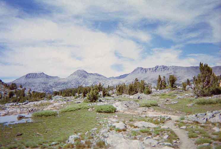
Island Pass
| Island Pass along the John Muir Trail
Island Pass
Maps & Miles
30 min Map
Island Pass
SOUTH
OF 17.36 miles 4.76 miles
Island Pass
Down the John Muir Trail
1.72 miles 2.24 miles 2.59 miles 3.81 miles
16.89 miles
|
Central & South Yosemite Hiking Map
Ansel Adams Wilderness
Miles and Elevations
|
|
| Upper Trail Junction along the John Muir Trail Maps & Miles
|
Island Pass
turning around
LOOKING NORTHWEST
Donohue Peak Left, Koip Crest Right
 |
||
Turning around and looking North, back at Donohue Peak on the Left, what I call, "The Triangle," centered in the image, with the Koip Crest along the Right, just steps after crossing Island Pass.
|
Central & South Yosemite Hiking Map
v
|
v
|
R PeakF Lake Loop Junction 1.86 miles from the Raymond Lake junction South to Raymond Canyon. 3.68 miles from the Raymond Lake junction South to Pennsylvania Creek. |
F Lake Loop JunctionElevation: 75 Mileage: .91 miles from E Summit |
| N Lake's |
| Next
Crossing Down!
WE make our way down to the Rim of the Merced River, then down the North Canyon Wall to Little Yosemite Valley, where we will spend the evening. |
North: Lyell Canyon to Donohue Pass South: Island Pass to Thousand Island Lake
Backpacking |
The Golden Triangle Yosemite is a large National Park that I break down into North, Central, and South regions for the convience of the Long Distance Backpacker. We hike into the most Northwestern region of Yosemite through Bond or Dorothy Lake Passes on the Tahoe to Yosemite and Pacific Crest Trails, respectively. To our East-Northeast are the Hoover Wilderness Trailheads, to our South-Southwest lays the Grand Canyon of the Tuolumne River. We arrive at roughly the center of the Sierra Nevada arriving at Tuolumne Meadows. Here the end of the Tahoe to Yosemite Trail is supplanted by the John Muir Trail heading South along the Sierra Crest from Tuolumne Meadows. Since I consider everything South of Tuolumne Meadow to be the South Sierra, our explorations of the center of Yosemite will be quite limited. Unless we take an alternative route that will run us down to Yosemite Valley and back up to the JMT 5.6 miles South of Tuolumne Meadows in Lyell Canyon.
THIS PAGE IS UNDER CONSTRUCTION: STAY TUNED FOR MUCH MORE! COME ON BACK NOW, 'YA HEAR?
7.5 Map:
30 min Map
|
Backpacking Trail Guide PCT-JMT |
 |
Backpacking Trail Guide PCT-JMT |
Backpacker ForumsHave a great trip or story to relate about Yosemite or in the Sierra Nevada? Post it on Above we come to the Front Page of the High Backpacking Trails and Topics Forums. Below we break the forums down into categories:
The Trails Forum acts as your place to put up input, comments, relate your experiences, or ask questions about each segment and spot along the length of our combined TYT-PCT-JMT trails. The Forum is your place to supplement the trail guide. Anyone can post text comments in the existing forums, but only members can post up new topics, along with images, maps, and formatting. If you have experiences, comments, questions, or pictures and videos of the Pacific Crest Trail between Sonora Pass and Tuolumne Meadows, post up here as an unknown hiker or as a member: Forum Section
|
Trailhead
Contact
Alex Wierbinski

Backpacking Lake Tahoe to Mount Whitney
Your Guide to the High Sierra Crest, including the Tahoe to Yosemite, Pacific Crest, and John Muir Trails
