High Sierra
Backpacking
Main
Trail Guide
TRAILHEAD
High Sierra
MAGAZINE
ALL BLOG
The Trails
Guide
Maps
Miles/Ele
Permits
Resupply
Forum
Current Weather Conditions
Weather Notes
Northern High Sierras
Central High Sierras
Southern High Sierras
Gear
Gear List
Gettin Started
Layering
Discussion
Testing yourself and your gear
Gear Reviews
Backpacking
Lake Tahoe to Mount Whitney
Trail Guide Section
INDEX
Hiking
Tuolumne Meadows
to
Reds Meadow Pack Station
Hiking
The John Muir Trail
Languages
Translate
Trail Skills
The trail
Navigation
Camp skills
Paper Maps
Off the trail
Scrambling
Mountain
Safety
Safety Topics
Safety
Incidents
Mosquito Info
Skeeter News
Food
Resupply
FORUM
Food
Planning
40 Days to Whitney
Introduction Tahoe to Whitney
Introduction Tahoe-Yosemite
Trail Arts
Art of walking
Physical
Preperation
More
Information
Links
News
and
Science
Books
Trail Stories
Photo
Catagories
Social
Trail Culture
Groups
Terms and Conditions of Use
Yosemite National Park
North |
Standard
|
South |
||
|
||||
Golden Triangle Tuolumne Meadows
Golden Triangle |
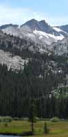
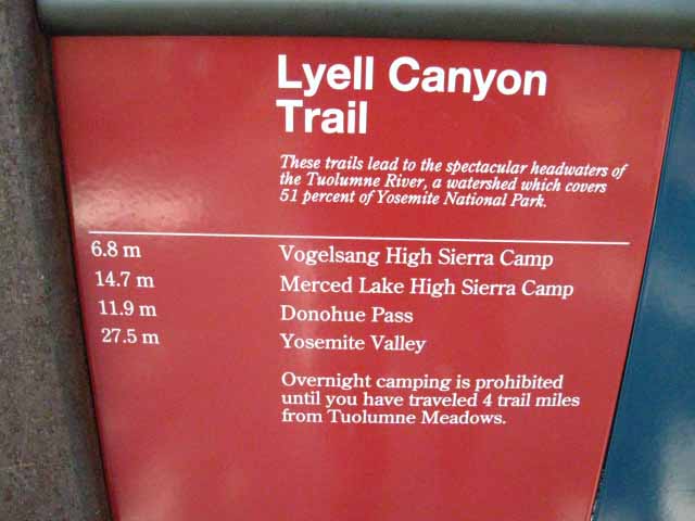
Tuolumne Meadows We've hiked to the center of the Sierra Nevada at Tuolumne Meadows from Lake Tahoe. Our long hike down the North Sierra along the Tahoe to Yosemite Trail has ended at Tuolumne Meadows. The South end of the TYT at Tuolumne Meadows marks the point where it is replaced by the John Muir Trail as the companion trail to the Pacific Crest Trail down the South Sierra as the TYT was in the North Sierra. Those of us continuing South down the JMT from Tuolumne Meadows are either Tahoe to Whitney hikers continuing down the Sierra Crest or JMT hikers arriving at Tuolumne Meadows after finishing their massive climb out of Yosemite Valley. Some of us have turned down the JMT from Tuolumne Meadows to hike through the Yosemite Valley as part of the "Golden Triangle" alternative route. Their "Golden Triangle" route rejoins the Southbound JMT 5.6 miles South up Lyell Canyon via the trail junction coming down from Voglesang High Sierra Camp,
STANDARD John Muir & Pacific Crest Trail South over Donohue and Island Passes to Reds Meadow
The Southbound JMT out of Tuolumne Meadows
Post up your experiences, information, and your questions and comments about backpacking into and out of Yosemite Valley. |
Tuolumne Meadows to Yosemite Valley |
Trail Guide Pages
|
7.5 minute Maps |
30 minute Maps
|
| N Lake's |
North: Sonora Pass to Tuolumne Meadows South: Reds Meadow to Vermilion Valley
Tuolumne Meadows |
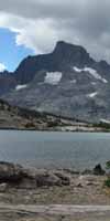
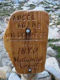
John Muir and Pacific Crest Trails We exit the Yosemite Wilderness through Donohue Pass to enter the Ansel Adams Wilderness of the Inyo National Forest.
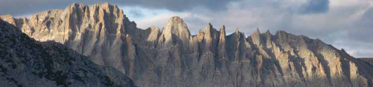
This rather short section of trail between our Tuolumne Meadows and Reds Meadow resupply spots is anything but short. The terrain between Tuolumne Meadows and Reds Meadow is chock-full of local peaks to climb, incredible granite scrambles and explorations around/to isolated lakes and some of the most beautiful seculded places I have ever seen. I have hiked from Tuolumne Meadows to Reds Meadow using one full day, overnight at my favorite lake near Island Pass, and then down to Reds Meadow well before Noon the second day of hiking. That is just crazy! WHY? #2> The meadows running from the South base of Donohue Pass to where we begin the climb up to Island Pass are other-worldly. One need to linger through these meadows of moss, rock, and whitebarks along the granite banks and tranquil pools of Rush Creek. #3> The terrain on the South side of Island Pass all the way up to Catherine Lake and the backside way up Banner that would take me decades of High Sierra backpacking trips to really explore. And we have not even explored the triple-split of the trails South of Thousand Island Lake, where the JMT stays high up on the granite West wall of the Middle fork of the San Joaquin gorge, the PCT breaks off to hike on the West wall, and a third trail, the River Trail, runs down the middle of the canyon to Reds Meadow between them. The JMT stays up in the stunning series of granite and forest encrusted lakes stashed in granite folds in the terrain on the West side of the Canyon of the San J river while the PCT runs South down the barren, exposed East flank. My favorite, the most beautiful, and the hardest of the three trails between Thousand Island Lake and Reds Meadow is the John Muir Trail, by far. I prefer the JMT route over this small barren length of the PCT anytime, even if I had not walked either before, and even if I had already walked the JMT and not the PCT. That is how much superior this segment of the JMT is than the route of the PCT from Thousand Island Lake to Reds Meadow.
THIS PAGE IS UNDER CONSTRUCTION: STAY TUNED FOR MUCH MORE! COME ON BACK NOW, 'YA HEAR?
|
Backpacking Trail Guide TYT & PCT Sonora Pass |
 |
Backpacking Trail Guide JMT South |
Backpacker Forums Have a great trip or story to relate about Yosemite or in the Sierra Nevada? Post it on Above we come to the Front Page of the High Backpacking Trails and Topics Forums. Below we break the forums down into categories:
The Trails Forum acts as your place to put up input, comments, relate your experiences, or ask questions about each segment and spot along the length of our combined TYT-PCT-JMT trails. The Forum is your place to supplement the trail guide. Anyone can post text comments in the existing forums, but only members can post up new topics, along with images, maps, and formatting. If you have experiences, comments, questions, or pictures and videos of the Pacific Crest and John Muir Trails from Tuolumne Meadows to Reds Meadow, post up here as an unknown hiker or as a member: Forum Section
|
North: Sonora Pass to Tuolumne Meadows South: Reds Meadow to Vermilion Valley
Trailhead
Contact
Alex Wierbinski

Backpacking Lake Tahoe to Mount Whitney
Your Guide to the High Sierra Crest, including the Tahoe to Yosemite, Pacific Crest, and John Muir Trails
