Tree, Poison Flat, Carson Iceberg Lake Tahoe to Mount Whitney: Your Backpacking Guide to the High Sierras Yellow Flower
Leavit Peak in December with Snow Plume
Dome
Peak
Dome


The Trails

Guide
Maps
Miles/Ele
Permits
Resupply
Forum


Current Weather Conditions

Weather Notes
Northern High Sierras
Central High Sierras
Southern High Sierras
 

Gear

Gear List
Gettin Started
Layering
Discussion
 
Testing yourself and your gear
 
Gear Reviews

top of page

Thousand Island Lake
to
Agnew Meadows

Pacific Crest Trail
Miles and Elevations

Backpacking
Ansel Adams Wilderness

Backpacking Miles and Elevations on the Pacific Crest Trail in the Middle Fork of the San Joaquin


Languages

Translate


Trail Arts

The art of walking
 
Physical Preperation


Trail Skills

The trail
Off the trail
Scrambling
Maps
Navigation
Camp skills
 

Food

Resupply
Food


Other

Photo Catagories
 
Trail Stories
 
Trail Culture
 
News and Science
 
Links
 
Groups
 
Books
 

top of page

MILES
NORTH

JMT-PCT

Tuolumne Meadows
to
Thousand
Island Lake

MILES
SOUTH

JMT-PCT

Reds
Meadow
to
Vermilion
Valley Resort

MILES
SOUTH

ALT-ROUTE

Reds
Meadow
to
VVR
via
Goodale
Pass

ALTERNATIVE
ROUTES

THIS PAGE BELOW
PCT

RIVER TRAIL

JMT

TRAIL
GUIDE
INDEX

Tuolumne
Meadows
to
Reds
Meadow

MAPS
INDEX

Tuolumne
Meadows
to
Reds
Meadow

ALL
MAPS

INDEX

TRAIL
GUIDE

INDEX

PERMITS

Yosemite

Wilderness Area

Miles & Elevations

Pacific Crest Trail
Variant


Thousand Island Lake
to
Agnew Meadows


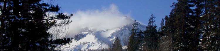
Once we hike the combined JMT-PCT South from Tuolumne Meadows to 1000 Island Lake we find three routes South from there to two points in "civilization," being Agnew and Reds Meadows.

These three routes are the JMT, the PCT and the River Trail. Below on this page find the lineup for the 8.55 miles of the Pacific Crest Trail's route from 1000 Island Lake to Agnew Meadows and its shuttle stop to Mammoth Lakes.

The links below lead to the pages with the miles of these other two routes, the JMT and the River Trail from 1000 Island Lake to Reds and Agnew Meadows, respectively. Each of these three trails has its own unique character.


JMT
The JMT is the longest and most scenic of the 3 routes. It runs through the complex granite making up the West wall of the canyon.

River Trail
The River Trail is the shortest, shadiest, and has the sofest surface. It runs down the center of the canyon along this uppermost segment of the Middle Fork of the San Joaquin River.

PCT
The PCT runs South on the exposed volcanic Eastern wall of the canyon. While this is not the most stimulating segment of the PCT, it does offer excellent views of the amazing terrain the JMT crosses that's cut into the granite West side of the canyon.

The PCT's exposed position also gives us good views of the forest around and along the Middle Fork of the San Joaquin below us that's shading the soft trailbed of the River Trail in the center of the canyon running along the cool river, parallel with the route of the PCT.


John Muir Trail:
1000 Island Lake to Reds Meadows: West Flank


River Trail:
1000 Island Lake to Agnew Meadows along
Middle Fork of San Joaquin


The
Pacific Crest Trail
Option


Thousand Island Lake
down the
Eastern
Canyon Wall


8.55 miles


to the
Mammoth Lakes Shuttle
at
Agnew Meadow


Total Miles
PCT Route Section

Tuolumne Meadows to Agnew Meadows
27.63 miles

The Exposed
PCT Route

to
Agnew Meadows Trailhead
&
Shuttle

The PCT route from Thousand Island Lake to Agnew Meadows on the volcanic terrain of the East wall of the canyon is across exposed terrain for the vast majority of its length.

The JMT route South through the complex granite terrain of the East wall of the canyon enjoys both more tree and more terrain cover.

The River Trail's rapid descent down the center of the canyon along with the Middle Fork of the San Joaquin River brings it rapidly under forest cover.

Descent
1575 feet over 8.55 miles

MAP
Donohue Pass to Reds Meadow Trail Map

Location  Elevation Mileage  
 
South of Tuolumne Meadows
Thousand Island Lake
PCT-JMT Junction
9843 19.08  
-230 1.00  
HIKING EAST-NE on PCT
to
First River Trail Junction
PCT Left
River Trail Right

South with the Middle San Joaquin
9613 20.08  
-33 .29  
HIKING EAST-NE on PCT
Second Junction,
PCT Right to pass Badger Lakes
9580 20.37  
  0 .27  
Badger Lakes Junction
Short spur trail South
9580 20.64  
-98 .38  

Third Junction: Triangle of Trails
PCT Left
PCT Middle
Right:
Second River Trail
Atop a great steep plunge of the River Trail down the throat of the Headwaters Bowl of the Middle San Joaquin, if one hikes to the Right on the River Trail here.

The PCT stays up on the Eastern Wall of the Canyon.

9482 21.02  
+328 .29  
Summit Lake Agnew Pass Junction
Southbound PCT Right onto East Wall of Canyon.
Trail North crosses Agnew Pass to overlook Gem Lake
9810 21.31  
-1542 6.05  
Agnew Meadows Road
Road links Agnew Meadow Trailhead with Minaret Road.
8268 27.36  
0 .27  
Agnew Meadow
Minaret Road Shuttle Stop
8268 27.63  


Mo Miles


TYT-PCT further North
Sonora Pass to Tuolumne Meadows 


JMT-PCT
NORTH
Tuolumne Meadows
to
Thousand Island Lake


JMT further NORTH
Yos Valley to Tuolumne Meadows
Miles and Elevations


JMT SOUTH
Reds to VVR
Miles and Elevations


Miles and elevations
INDEX
Lake Tahoe
to
Mount Whitney


top of page


Miles PCT North: Sonora Pass to Tuolumne Meadows                 Miles North: Yosemite Valley to Lyell Canyon


Notes


Miles and Elevations
Discussion and Notes
Desolation Trail

ahoe on H


Backpacker Forums

Have a great Sierra Nevada trip or story to relate? A fine piece of gear? Or gear that failed?

Post it on
TahoetoWhitney.Org

Above we come to the Front Page of the High Backpacking Trails and Topics Forums. Below we break the forums down into categories:

High Sierra Trails High Sierra Topics

The Trails Forum acts as your place to put up input, comments, relate your experiences, or ask questions about each segment and spot along the length of our combined TYT-PCT-JMT trails.

The Forum is your place to supplement the trail guide.

Anyone can post text comments in the existing forums, but only members can post up new topics, along with images, maps, and formatting.

Become a Member

If you have experiences, comments, questions, or pictures and videos of the John Muir and Pacific Crest Trails Vermilion Valley to Muir Ranch, post up here as an unknown hiker or as a member:

UNDER CONSTRUCTION

Forum Section
Vermilion Valley Resort to Muir Ranch
Forum Segment
Segment to Segment

Miles North: Sonora Pass to Tuolumne Meadows                              Miles South: Yosemite Valley to Lyell Canyon

Trailhead

Contact
Alex Wierbinski

top of page

Backpacking Lake Tahoe to Mount Whitney

Your guide to the High Sierra Crest, including the Tahoe to Yosemite, Pacific Crest, and John Muir Trails

© Lake Tahoe to Mount Whitney: Crown Jewel of the Pacific Crest Trail