


of
Carson Pass
to
Ebbetts Pass
An
Overview of the Pacific Crest Trail across the Mokelumne Wilderness
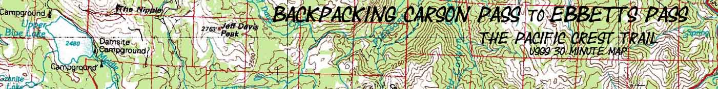
One 30 minute USGS Backpacking Topo Map, Toiyabe National Forest , Mokelumne Wilderness

| Pacific Crest Trail MAPS and MILEAGES |
Trail Guide | Tahoe to Whitney INDEXES |
More Miles and Elevations TYT |
PCT 7.5 Map Series |
Weather, Map Data | ||||||||||||||||
| PCT SOUTH Topo Maps INDEX Carson Gap to Highway 4 |
PCT |
TYT-PCT WEST Topo Map Carson Pass Region |
PCT-TYT further NORTH Carson Pass to Echo Summit |
PCT further SOUTH 30 min map Ebbetts Pass to Sonora Pass |
Trail Guide |
Trail Guide PAGE The Tahoe to Yosemite Trail |
Trail Guide INDEX Carson Gap to Carson Pass |
All Miles Tahoe to Whitney |
PCT Topo Maps INDEX Carson Gap to Highway 4 |
All Maps Tahoe to Whitney |
TYT Miles and Elevations Carson Gap to Lake Alpine |
Carson Pass to Lost Lakes |
Blue Lakes to U. Sunset Lake |
Upper Sunset Lakes to Ebbetts Pass |
|||||||
The Pacific Crest Trail
between
Carson Pass and Ebbetts Pass
27.88 miles
| Whole Mokelumne Wilderness Hiking Map |
Topo
Maps INDEX Carson Gap to Highway 4 |
| NORTH 30 min Topo MAP Carson Pass to Echo Summit |
Click Red & BLACK DOTS |
SOUTH 30 min Topo MAP Ebbetts Pass to Sonora Pass |
|
| NORTH 30 min Topo MAP Carson Pass to Echo Summit |
Click Red & BLACK DOTS |
SOUTH 30 min Topo MAP Ebbetts Pass to Sonora Pass |
| Whole Mokelumne Wilderness Hiking Map |
Topo
Maps INDEX Carson Gap to Highway 4 |
Mapology |
||||
MAP NOTE What's important for our general reference purpose is that each side of a square is 1000 meters, or a Kilometer. From my point of view that is 1093.6 yards or .62 of a mile. Diagonal: 1414.22 meters, if my trig is correct. That converts the diagonal distance into 4,639.8 feet or .88 of a mile.
|
Location |
|
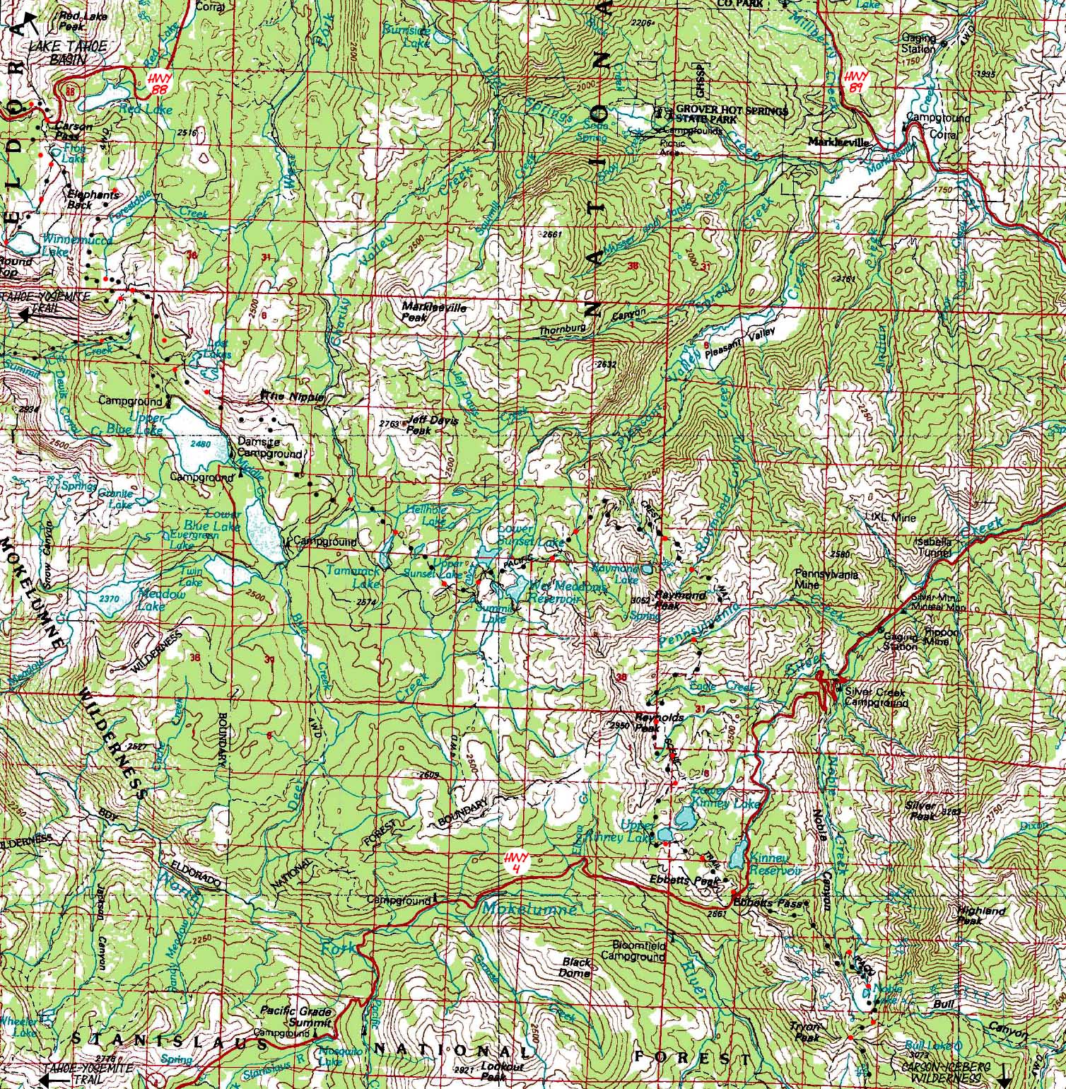
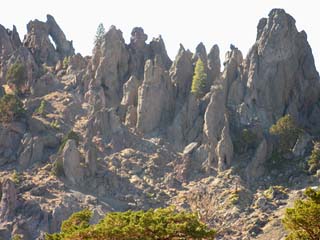
Main Features Since beginning this Tahoe to Whitney backpacking trip South we have been within the forests and mountains of the Western Lake Tahoe Basin. Now we have departed the Tahoe Basin through the Carson Gap and have hiked through Carson Pass on Highway 88 to follow the Pacific Crest Trail South along the extreme Eastern flank of the High Sierras down to Ebbetts Pass on Highway 4. The environment and terrain will change significantly from granites of Desolation Wilderness and the relatively moist forests we experienced in the Meiss Roadless Area before exiting the Lake Tahoe Basin. The Pacific Crest Trail route between Carson and Ebbetts Passes traces the Eastern flank of the Sierras, which is much more arid than the Western Tahoe Basin we just exited. South from the Carson Pass tree cover dissappears for a few exposed miles over to the Forestdale Divide, and when we again hike into some forest approaching Lost Lakes, we will notice it is a thinner forest than in the Tahoe Basin. We again exit forest to cross The Nipple above Blue Lakes. The Pacific Crest Trail route through this part of the Sierras traces the very Eastern edge of the range where it gets much less moisture than trails further West. Green fingers of forest do push themselves up the creek beds, interlacing themselves within barren patches of eroding mineral painted fingers off the ancient arid lava mountains that characterize the greatest lengths of the Pacific Crest Trail between Carson Pass and Ebbetts Pass. Great exposed sections of brightly-colored minerals are eroding out of mountainsides like great geological wounds, looking like mineral wounds bleeding out of the wounded mountains all around us, occassionally lighting-up the mountainsides with bright sections of mineral colors emphasizing the beautiful harshness within these long sections of almost barren terrain. Rather than experiencing the grand granites that the Sierras are famous for, this section features eerie reddish-to-purple volcanic spires with finger-like formations cut from vertical channels eroded down the mountain sides. These shapes are the stubborn remnants of ancient hard lava flows reflecting thousands of years of sculpting by the relentless hand of nature, revealing the naked power of sun, wind, ice, snow, and water. On the other side of the volcanic equation we also cross vast piles of fine granular material that has already eroded off the volcanic mountains is is now moving a bit further down-mountain every season. Between the barreness of The Nipple and Raymond Peak we cross a delightful forested section filled with a series of pretty lakes. Tamarack, Lilly Pad, and Upper & Lower Sunset Lakes are separated by a dotting of unnamed lakes. Local trails weave in and out of our main PCT route. If you wanted to stay in the granite, you should have followed the Tahoe to Yosemite route through Summit City Creek between Carson Pass and Lake Alpine. The Summit City Creek canyon is a granite safe protecting the isolation of the much less traveled TYT route. As does the rough unmaintained section between Summit City Creek and Camp Irene, which requires a bit more attention than the PCT route. But fear not. The Pacific Crest Trail will again encounter a brief section of granitic terrain South of Ebbetts Pass, where the trail follows the along the top of the Western wall of the golden granite canyon holding the East Fork of the Carson River. But that's much further South down the trail. After wrapping Southward around the Eastern side of Reynolds Peak you can begin to spy the thickening forests around Ebbetts Pass a bit further to your South. From Ebbetts Pass Southbound, the Sierra Crestline bends further West, putting a few more ridges and valleys between the Sierra Crest and the extreme Eastern edge of the Sierras. This has the effect of pushing the Sierra Crestline further West, and a little bit deeper into the rain zone. From the South Side of Raymond Peak increasing bits of forest cover will again begin to shade parts of your journey between the mountain tops and passes, until you again emerge from the forested sections when you climb up the headwaters bowl of the East Fork of the Carson River. What this arid section between Carson Pass and Ebbetts Pass means for your water needs is generally determined by the time of the season you pass through. By late Summer of a "normal" year (whatever that is...) you will find that most, if not all of the streams and tributaries feeding the main drainages have dried out. Many of the smaller lakes will be reduced to black ponds, or dried out completely. In the center of the drainage valleys the main drainages will still be flowing, but their flow may no longer reach up to the higher altitudes. Most tributaries that you will cross coming down to the main drainages will be dry in late Summer. So, late Summer and Fall backpackers hiking this section should only plan on watering up at the main drainages and bigger lakes between Carson and Ebbetts Pass.
Above: Awesome volcanic terrain on the South side of Raymond Peak |
CARSON PASS REGION ROAD MAP ROAD MAP Carson Pass (PCT) and Carson Pass Management Area (TYT) This is a road map for highway access to the trailheads on the North end of the trail map above. Centered On
|
ROAD MAP Ebbetts Pass (PCT) and Lake Alpine (TYT) This is a road map for highway access to the trailheads on the South end of the trail map above. Centered On
|
Mapping, Mileage, |
|
Miles and ElevationsCarson Pass to Ebbetts Pass: 27.88 miles Carson Pass to Ebbetts Pass point to point mileages and elevation
Backpacking to Ebbetts PassMeeks Bay to Echo Summit Carson Pass to Ebbetts Pass Total
On my Last trip on this particular trail route, which I hiked in September of 2009, it took me five nights to reach Ebbetts Pass from Meeks Bay. In this section between Meeks and Ebbetts I took two half-days of hiking. The first half-day was due to my very late arrival at the Meeks Bay trail head to begin the trip, and the second half-day was taken to hang out with Randy at Echo Summit, and enjoy the latter half of that day at Showers Lake.
Back to Tahoe to Lake Alpine Trail Guide Index
Back to The Trailhead |
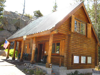
The MapMap Name Compass Offset scale Contours Backpacking PermitsThe Carson Pass exactly splits the boundary between the Toiyabe and El Dorado National Forests. Round Top and the local hiking area are so very popular a special management zone was created that encompasses the Round Top Massif including the Carson Pass trailhead heading South. Special Management Area: Carson Pass Management Area Heading North from Carson Pass takes you into the Meiss Roadless Area of the Lake Tahoe Basin Management Unit, which requires no backpacking permit for camping in the Meiss Roadless Area. The CPMA exclusively handles permitting out of Carson Pass. When it is open. The CPMA is managed by the Amador Ranger District of the El Dorado National Forest. When the CPMA cabin is closed the Amador Ranger District issues permits. National Forest: El Dorado National Forest Wilderness Area: Mokelumne (Fed Site) But it is not as simple as that. If you are driving to the Carson Pass from the East, from the Eastern Sierra and you are planning on hiking the PCT South out of Carson Pass, you may be able to talk the Carson Ranger District of the Toiyabe National Forest into issuing you a permit. The PCT heading South out of Carson Pass runs directly into the Toiyabe managed section of the Mokelumne Wilderness, and stays within the Toiyabe NF far beyond Ebbetts Pass. The Carson Ranger District will not issue you a permit to stay anywhere in the CPMA. But they may issue you a permit heading South on the PCT from Carson Pass. I've walked into Carson Ranger District stations on the East side of the Sierra and have had them issue me permits to begin backpacking trips that were substantially within Toiyabe NF, even through these trips began at trailheads in the Stanislaus and El Dorado National Forests. There was no way I could hitch-hike West, all the way over the Sierra Crest to pick up a permit and then hitch back. I had just finished a trip from the Tahoe Basin around Round Top Lake and back, and needed to get a permit to hike from Sonora Pass (Stanislaus NF) South from the East side of the Sierra. I have found that the staffs at all the Ranger Districts I have come in contact with will bend over backwards to make your trip happen. Good People. Thanks to the Staff. National Forest: Toiyabe National Forest Wilderness Area: Mokelumne (Fed Site) The Carson Ranger District of the Toiyabe National Forest is the unit that administers the Eastern Mokelumne Wilderness South from Carson Pass as well as the East side of the Carson Iceberg Wilderness down to Sonora Pass. If you are entering the Pacific Crest Trail Northbound from Ebbetts Pass you will obtain your permit from the Carson Ranger District of the Toiyabe National Forest. Physical location of the Trail: Between Highway 88 at the Carson Pass, and Highway 4 at Ebbetts Pass. |
 |
|
The Carson Pass Cabin
|
|
 |
|
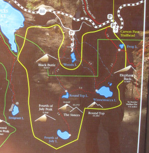
The Carson Pass Management Area map |
|
Next topo map North: Carson Pass to Echo Summit Next topo map South: Ebbetts Pass to Sonora Pass
| Elevations | More Information | ||
Carson Pass The Nipple Raymond Peak South side of Reynolds Peak Ebbetts Pass |
Trail Guide
Trail Guide |
||
Map CreditThanks, USGS! |
U.S. Geological Survey The USGS Move the Map to the Sierras. Select size of Maps you wish to locate. Click "Mark Point" on map to see the USGS map grid of the selected map scale. USGS Topographic |