


EMIGRANT WILDERNESS BACKPACKING MAPS
PCT
Hiking South side of Leavitt Peak to Dorothy Lake Pass on the Pacific Crest Trail
The Toiyabe National Forest
Including our alternative route over Big Sam into Emigrant Wilderness to the Tahoe to Yosemite Trail
Four 7.5 minute USGS Topo Backpacking Maps

Maps |
Topo Map |
Topo Map |
Trail Guide INDEX Trail Guide PAGE Kennedy |
PCT |
TYT |
Click RED DOTS for links to Trail Guide Pages |
All |
RESUPPLY |
PERMITS |
WEATHER |
The Pacific Crest Trail Topo Hiking Map down Kennedy Canyon around Emigrant Wilderness to Dorothy Lake Pass
MAGNIFY THIS MAP!
| Map Northwest TYT TYT Kennedy Meadows to Relief Reservoir |
Map North PCT Sonora Pass to Kennedy Canyon trail junction |
Click Red Dots |
East Flank PCT S across Dorothy Lake Pass into Yosemite or NE to Leavitt Meadow |
Map South PCT & TYT Yosemite! Jack Main Canyon to Tilden Lake Loop and Wilmer Lake |
|
| Map Northwest TYT TYT Kennedy Meadows to Relief Reservoir |
Map North PCT Sonora Pass to Kennedy Canyon trail junction |
Click Red Dots |
East Flank PCT S across Dorothy Lake Pass into Yosemite or NE to Leavitt Meadow |
Map South PCT & TYT Yosemite! Jack Main Canyon to Tilden Lake Loop and Wilmer Lake |
Map and Trip Notes, Map Anomalies. |
||||
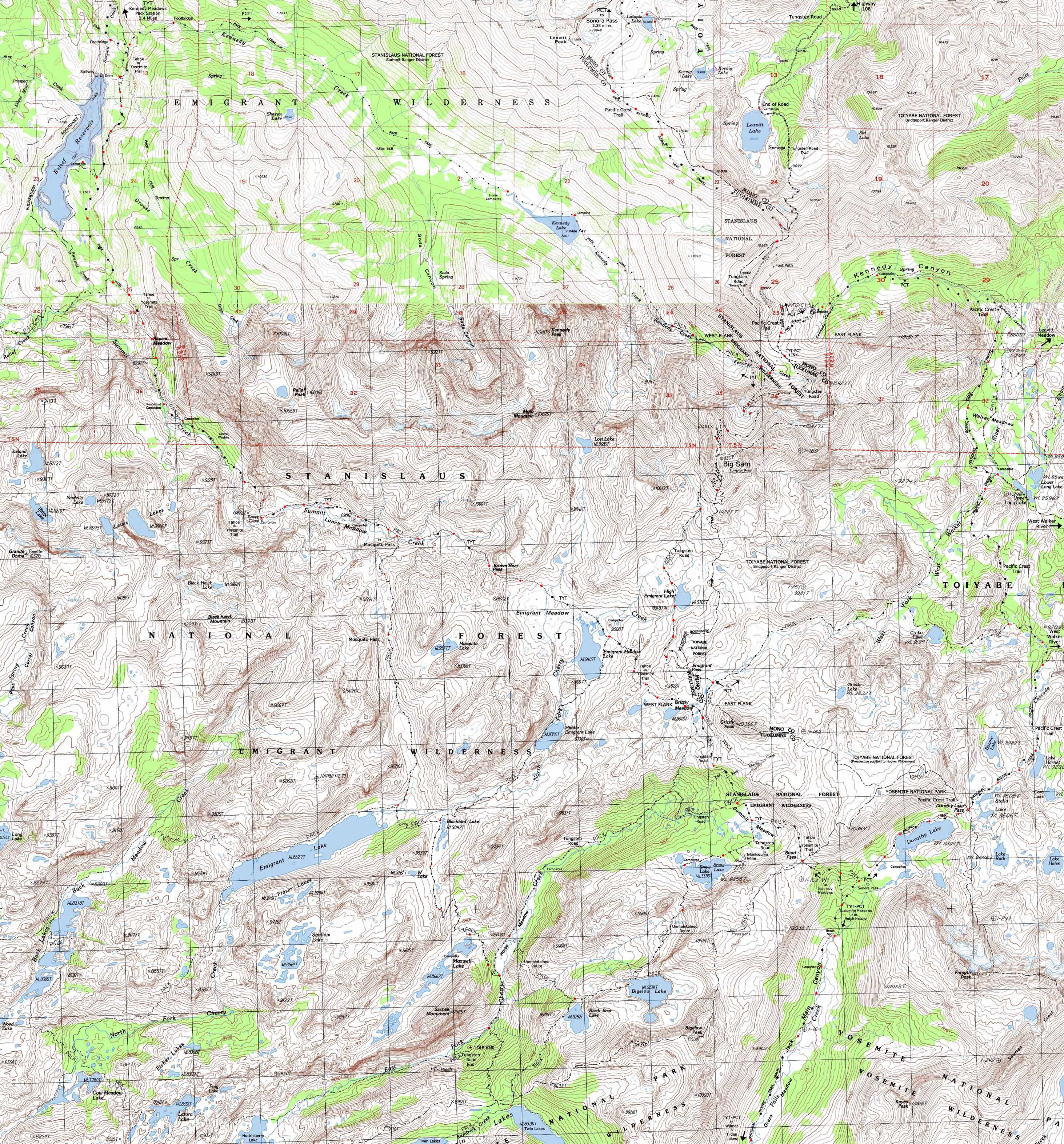
Main Features In the topo hiking map above we can see the trail coming East from the Tahoe to Yosemite Trail & Kennedy Meadows up to Kennedy Lake. Just East of Kennedy Lake we access the PCT at the top of Kennedy Canyon. From Kennedy Canyon trail junction on the PCT we have the option of hiking South on the Tungsten Road over Big Sam to link up with the TYT under Grizzly Peak. From Grizzly Peak we can turn Northeast towards Leavitt Meadow via the West West Walker River Bridge. At the WW Walker River Bridge we can also follow the PCT North back to the Kennedy Canyon trail junction. Continuing South from Grizzly Peak these various routes across Emigrant Wilderness may now join the Pacific Crest Trail at the top of Jack Main Canyon in Yosemite for the hike South to Tuolumne Meadows, or turn North back towards the Kennedy Canyon trail junction to bend great loops hiking around the stunning beauty of the Emigrant Wilderness. In fact, a hike starting at Sonora Pass can bend a small circle route to Kennedy Meadows via Kennedy Lake, a longer loop to Kennedy Meadows via Grizzly Meadow, or a very long loop turning back North on the PCT through Bond Pass. Map Notes The main feature of the four USGS maps I put together above are the USGS errors with trail placement on the provisional Pickle Meadow Map, which covers the Pacific Crest Trail from the Southeastern ridge of Leavitt Massif & the PCT through Kennedy Canyon. The problems concern omitting the Pacific Crest Trail route where it intersects with the Tungsten Road on the South end of Leavitt Peak above Leavitt Lake on the USGS Sonora Pass map and placement of the Pacific Crest Trail route at the top of Kennedy Canyon, the West side, as well as at the bottom of Kennedy Canyon on the USGS Pickle Meadow map. The trail through Kennedy Canyon and its accompanying trails have been significantly altered since the 1979 revision of the Pickle Meadow map. The position of the trails on the provisional Pickle Meadow map, the upper Right map, do not line up with the positions of trails on the finished Tower Peak map, the lower Right map. My route modification describes the 2012 status of the PCT through upper Kennedy Canyon. More importantly, A there has been a significant rerouting of the PCT between the ford in upper Kennedy Canyon to where the marked trail picks up at the base of Kennedy Canyon. The trail crosses the creek as indicated on the modified map above, and proceeds down the South side of the creek into Walker Meadow. There trail as depicted on the North side of the creek down Kennedy Canyon is no longer maintained. The provisional Pickle Meadow map has significant problems that have been corrected on the map above. The geographic features are consistent across all the maps. No problem there... I am working on these maps and will revise them to 2012 conditions as work proceeds. MORE MAP NOTES What's important for our general reference purpose is that each side of a square is 1000 meters, or a Kilometer. From my point of view that is 1000 yards or .62 of a mile. Diagonal: 1414.22 meters, if my trig is correct. That converts into 4,639.8 feet or .88 of a mile.
top of page |
Permits, Mapping, Mileage, and National Forest Information |
|
|
Four USGS 7.5 min Topo Hiking Maps Four USGS Northwest Map Northeast Map Southwest Map Name Southeast Map Name Compass Offset
Physical location: |
| Backpacking Permitting Authorities | |
West Side and Sonora Pass Stanislaus National Forest Wilderness TahoetoWhitney Contacts: Stanislaus National Forest National Forest Wilderness Area information: Emigrant WildernessRanger District: Summit Ranger District |
East Side Leavitt Lake and West Walker through Leavitt Meadow Toiyabe National Forest WildernessTahoetoWhitney Contacts: Toiyabe National Forest National Forest Wilderness Area information: Ranger District: Bridgeport Ranger District |
next map: last map:
| Elevations | More Information | ||
Lake Tahoe: feet Meeks Bay Trail head: feet elevation rise: meters, or feet |
|||
Map Credit |
U.S. Geological Survey, Department of the Interior: The USGS Move the Map to the Sierras. Select size of Maps you wish to locate. Click "Mark Point" on map to see the USGS map grid of the selected map scale. |