


Bensen Lake to Virginia Canyon Backpacking Map
North Yosemite National Park Hiking Map
The "Washboard"
or
"The Five Canyons of the North Yosemite Backcountry"
30 minute USGS Backpacking Map

| PCT-TYT MAPS |
TRAIL GUIDE INFORMATION |
Tahoe to Whitney INDEXES |
More Miles and Elevations | 7.5 Map Series | Weather, Map Data | ||||||||||||||||
| PCT MAPS INDEX Sonora Pass to Tuolumne Meadows |
30 min map NORTH Sonora Pass to Bensen Lake |
30 min map |
Miles and Elevations Sonora Pass to Tuolumne Meadows |
Trail Guide PAGE Bensen Lake |
Section INDEX Sonora Pass to Tuolumne Meadows |
Trail Guide INDEX Tahoe to Whitney |
All Miles INDEX Tahoe to Whitney |
All MAPS Tahoe to Whitney |
Ebbetts Pass to Sonora Pass |
Section MAPS Sonora Pass to Tuolumne Meadows |
All MAPS Tahoe to Whitney |
PERMITS |
Resupply Kennedy Meadows -- Tuolumne Meadows |
||||||||
FULLY LINKED
TOPO HIKING MAP
Click the Map
to
SEE
DETAILED MAPS
Backpacking Map:
Southbound
Pacific Crest Trail Exit
through the
NORTH YOSEMITE
"Washboard"
North: Sonora Pass to Bensen Lake Click the Map South: Virginia Canyon to Tuolumne Meadows
North: Sonora Pass to Bensen Lake Click the Map South: Virginia Canyon to Tuolumne Meadows
Click the Map
LINKED
to
Detailed
Emigrant and Yosemite Wilderness
Backpacking Maps
Also See
North: Sonora Pass to Bensen Lake Grand Canyon of the Tuolumne Backpacking Map South: Virginia Canyon to Tuolumne Meadows
North: Sonora Pass to Bensen Lake Click the Map South: Virginia Canyon to Tuolumne Meadows
Also See
Grand Canyon of the Tuolumne
Backpacking Map
Location Notes |
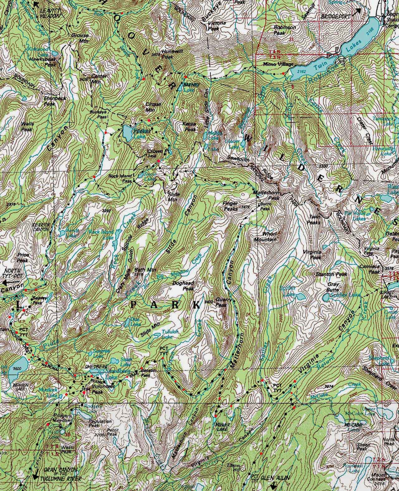
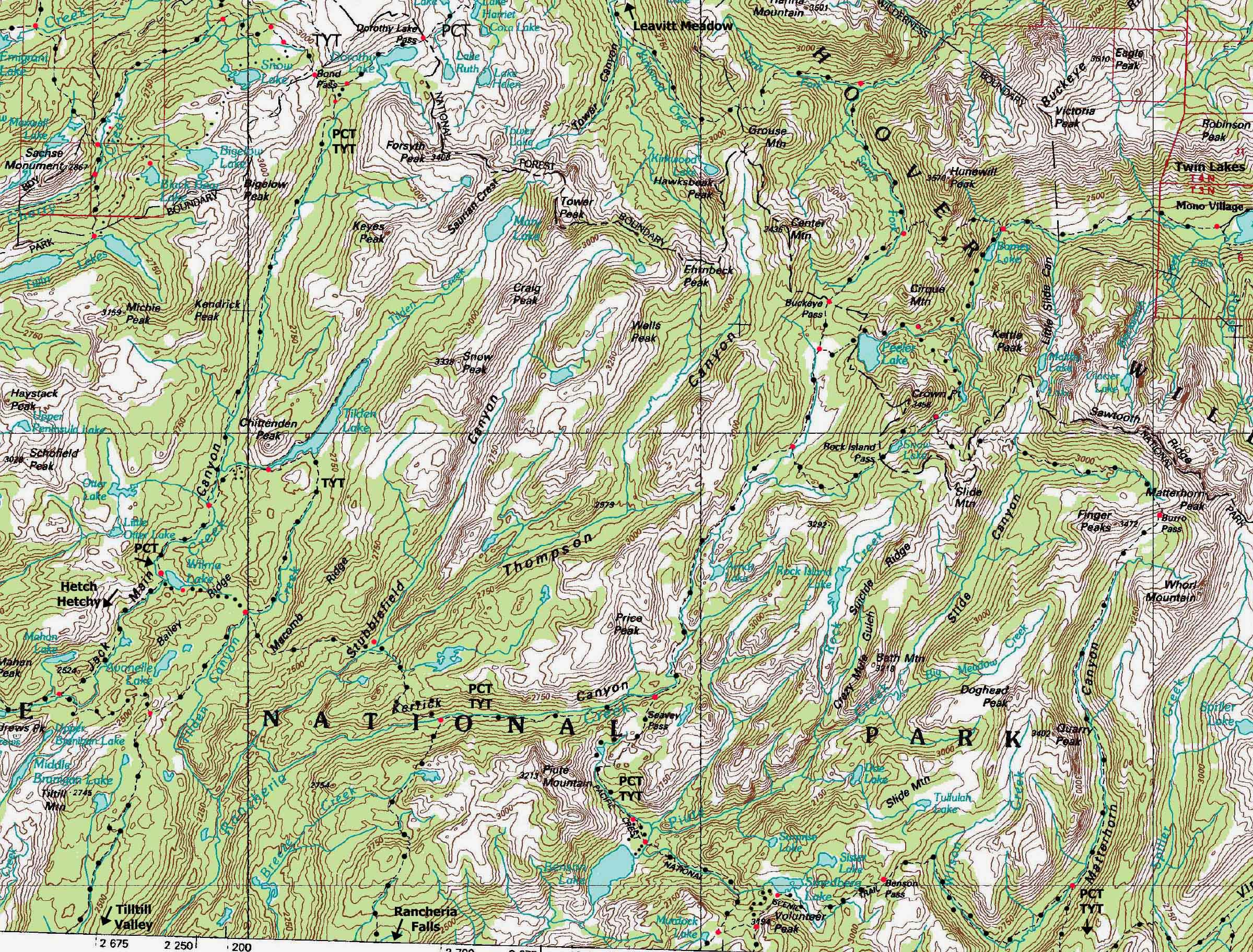
Main Features Beyond the PCT and TYT This map includes the trails running up the canyons between the ridges running up to the Sierra Crest from our combined TYT & PCT route, which illustrates the trails leading over the Sierra Crest to Hoover Wilderness Trailheads along the East flank of the Sierra. The reasons are twofold: first, to get as wide a context on the surrounding terrain and mountains as possible. Second, the map above puts the Twin Lakes Trailhead over on the East Flank of the Sierra in the Hoover Wilderness into context with our long trails across and around the North Yosemite Backcountry, specifically the Bensen Lake Loop. The map above shows the Bensen Lake Loop's shared section of trail on our main trails, the combined TYT and PCT, along with it's route down Kerrick Canyon to access the PCT and its route off the PCT up Matterhorn Canyon on the Bensen Lake Loop's route to and from Twin Lakes. Hoover Wilderness The Virginia Canyon to Tuolumne Meadows 30 min map also depicts the Lundy Canyon and Saddlebag Lake Trailheads accessing the Harvey Monroe Hall Research Natural Area, and the East Flank of Mount Conness, although these two East flank trailheads link with each other, they don't offer trail access to our PCT-TYT through-route running down Cold Canyon. Click the PCT-TYT route on map above in Virginia Canyon to see detailed maps to our East of the Green Creek and Virginia Lakes Trailheads in the Hoover Wilderness and click the map lower down in Cold Canyon to see the detailed map of the Lundy Canyon and Saddlebag Lake Trailheads in the Harvey Monroe Hall Research Natural Area. |
Mapology |
||||
MAP NOTE What's important for our general reference purpose is that each side of a square is 1000 meters, or a Kilometer. From my point of view that is 1093.6 yards or .62 of a mile. Diagonal: 1414.22 meters, if my trig is correct. That converts the diagonal distance into 4,639.8 feet or .88 of a mile.
|
Tuolumne Meadows Roadmap
Tuolumne Meadows Tuolumne Meadows Resupply Page
Highway 120 Corridor
Highway 395 Corridor
Highway 108 Corridor
|
North: Sonora Pass to Bensen Lake Click Red Dots South: Virginia Canyon to Tuolumne Meadows
Mapping, Mileage, |
|
The elevation information below highlights the visual presentation of this precipitous terrain above. We are hiking through the Southern Half of the well-named "Five Canyons of the North Yosemite Backcountry," also know as "The Washboard." The elevation figures below indicate our route rapidly ascends and descends a series of closely spaced High Sierra ridges just below the Western flank of the Sierra Crest. This segment of our trail is composed of harsh climbs and steep descents, at least until we hike South into the bottom of Virginia Canyon. Though we have another climb South up to the top of Cold Canyon, the terrain is noticably moderating, and once we reach the top of Cold Canyon we face a long downhill hike to Glen Aulin. Click the red dots to see the trail guide entry for that location, and click the main route of the combined PCT-TYT for the underlaying highly detailed 7.5 minute topo map. |
USGS Maps Bridgeport Calif, 1985, Yosemite Valley, Calif, 1976,
Compass Offset
scale Contours
Backpacking permitting authorities:National Forest, Northeast of Yosemite Wilderness Area Toiyabe Ranger District |
North: Sonora Pass to Bensen Lake Click Red Dots South: Virginia Canyon to Tuolumne Meadows
| PCT-TYT Elevations |
FORUM | ||
Seavy Pass: 9120 feet Bensen Lake: 7581 feet Bensen Pass: 10160 feet Matterhorn Canyon: 8480 feet High Point South of Miller Lake: 9560 feet Virginia Canyon: 8560 feet |
Trail Guide, Section |
||
Map Credit |
||
U.S. Geological Survey, Department of the Interior Download all the maps you need for FREE! Move the Map to the Sierras. Select size of Maps you wish to locate. Click "Mark Point" on map to see the USGS map grid of the selected map scale. USGS Topographic
|