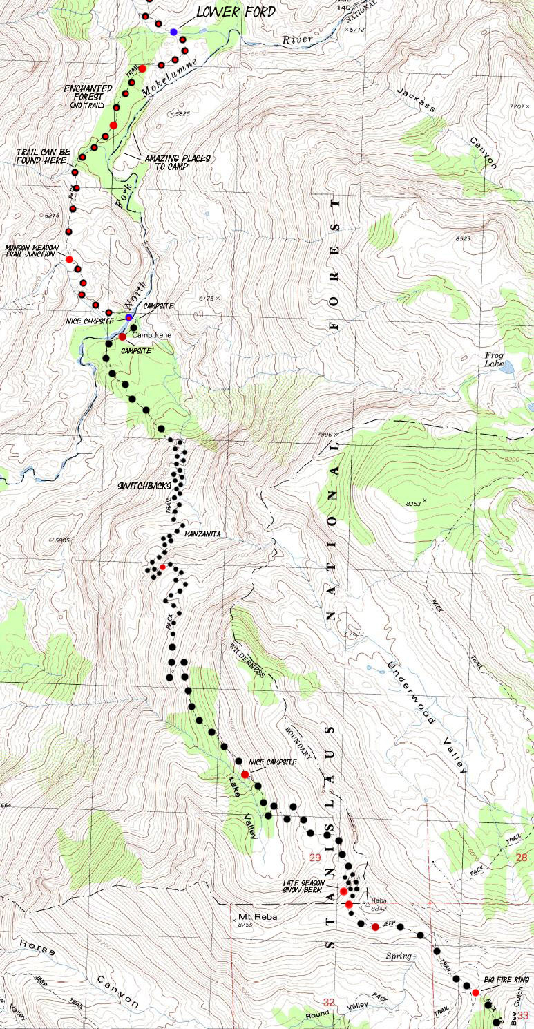


BACKPACKING MAP: Lower Ford of Summit City Creek over Mount Reba to Bee Gulch
Hiking The Tahoe to Yosemite Trail between Summit City Creek and Mount Reba
7.5 minute custom USGS Backpacking Map of the Mokelumne Wilderness in El Dorado & a bit of the Stanislaus National Forest

| Tahoe to Yosemite Maps and Mileages | More Information | Tahoe to Whitney Indexes | More Miles and Elevations | Random | Weather, Map Data | |||||||||||||||
Map |
Map South Bee Gulch to Lake Alpine |
Miles and Elevations Carson Gap to Lake Alpine |
Region Map Echo Summit to Lake Alpine |
Section Maps Lake Tahoe to Highway 4 |
All Miles Tahoe to Whitney |
All Maps Tahoe to Whitney |
Echo Summit to Carson Gap | Lake Alpine to Saint Marys Pass | 1x2 Section Map Carson Gap to Lake Alpine | Trail Guide Page Lower Ford to Camp Irene | map, miles, elevations & permit information | |||||||||
8.18 miles from the Lower Ford of Summit City Creek to the Bee Gulch Trail Junction
North: Lower Ford to Telephone Gulch Click Red Dots All Summit City Creek South: Lake Alpine

|
North: Lower Ford to Telephone Gulch Click Red Dots All Summit City Creek South: Lake Alpine
Mapping, Mileage, and National Forest Information |
|
Miles and Elevations
More Information Trail Guide: El Dorado National Forest information Trail Guide: Stanislaus National Forest information Physical location: Between Highway 88 at the Carson Pass to Highway 4 at Lake Alpine
US Forest Service websitesNational Forest Backpacking permitting authoritiesWilderness Area: Mokelumne in the El DoradoWilderness Area: Mokelumne in the Stanislaus |
USGS Map Information Map Name: Mokelumne Calif.-Nev., 1979, USGS 7.5 minute Topographic
Compass Offset: Magnetic North is 16 and 1/2 degrees East of True North
scale: 1:24 000 Contours: 40 feet The Tahoe to Yosemite Trail between Carson Pass and Lake AlpineBackpacking permitting authority: The El Dorado National Forest on the North Side of the Mokelumne Wilderness on Tahoe to Yosemite Trail at the Carson Pass on Highway 88. The Stanislaus National Forest administers the South side of the Mokelumne Wilderness, if you are enterning the Wilderness from the Lake Alpine area on Highway 4.National Forest: You are in the El Dorado NF from Carson Pass, until you reach the ford of the Mokelumne River at Camp Irene. Here you depart the El Dorado NF and enter the Stanislaus NF. The Mokelumne Wilderness continues within the Stanislaus NF up to the top of Mount Reba. At the top of Mount Reba you exit the Mokelumne Wilderness. |
Guide Pages Back to Tahoe to Alpine Trail Guide Index North to Round Top Lake South to Lake Alpine |
|
North: Lower Ford to Telephone Gulch South: Lake Alpine
| Elevations | More Information | ||
Lower Ford: 5540 feet Camp Irene: 5820 feet Mount Reba: 8720 feet
|
Guide Index North: TYT Carson Gap to Lake Alpine Guide Index South: Highway 4 to 108 Map Section: Echo Summit to Lake Alpine on a map: Click Red Dots for trail guide pages. Trail Guide Pages: Summit City Creek & Lake Alpine Google Map: Note Dirt Road North of Lake Alpine |
||
Map Credit: Thanks, USGS ! |
U.S. Geological Survey, Department of the Interior The USGSDownload Free USGS Topo Maps I love these guys... Move the Map to the Sierras. Select size of Maps you wish to locate. Click "Mark Point" on map to see the USGS map grid of the selected map scale. USGS Topographic Maps |