High Sierra
Backpacking
Trail Guide
Forums
Sierra
Weather
WeatherNotes Northern
Sierra Weather
Gear
Long Distance
High Sierra Backpacker Resupply
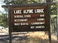
The Lake Alpine Lodge
and
Bear Valley
Hiking the
Tahoe to Yosemite Trail
Languages
Trail Skills
Mountain
Safety
Food
Planning
Trail Arts
More
Information
Social
| Resupply Index | Resupply Tips | Food Daily Menu Video |
Planning and Packing for Resupply 5 day food suppl video |
Backpacker's Planning Forum | MILES AND ELEVATIONS |
GUIDE PAGES | MAPS | All Wilderness Permits | Permits |
| Resupply North |
Resupply South Kennedy Meadows |
|||
| South Lake Tahoe | Echo Chalet | |||
Highway 4
High Sierra Backpacker Resupply
The Lake Alpine Lodge
Bear Valley, and Arnold 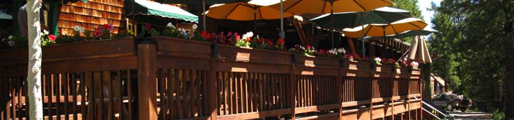
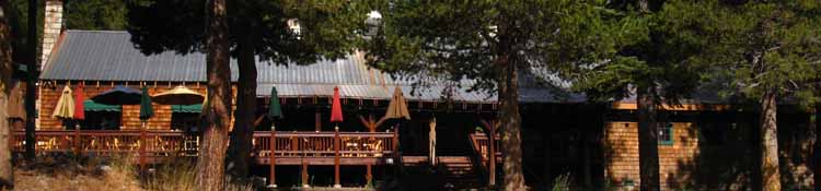
Above: Fine dining on the deck overlooking Lake Alpine. Rustic dining room with great fire sits inside.
The Lake Alpine Lodge Your Hosts
Kim
Lake Alpine Lodge
LATEST Lake Alpine Region Maps
Lake Alpine Backpacker Information
Lake Alpine Backpacker Services
Lake Alpine Region Weather
Notes The Lake Alpine Lodge is one of my favorite resupply spots between Lake Tahoe and Mount Whitney.
BACKPACKER'S Don't make fires up there, even if you have a fire permit, if it is just too dry. Big Picture Sierra Crest and West Flank TYT While both PCT & TYT hikers find themselves with a hitch-hike between eight and nine miles West from their respective Highway 108 Trailheads, only the PCT hiker will have to hitch back up Highway 108 to the Sierra Crest to continue hiking South. The TYT hiker's route continues South through Kennedy Meadows Pack Station. The TYT hiker will walk, rather than hitch hike, back up to the Sierra Crestline... The Utility of Lake Alpine Lodge Lake Alpine Lodge
The TYT South We've exciting sections of trail to our North and South while sitting here relaxing, recharging, and resupplying at the Lake Alpine Lodge. Below we have information about Lake Alpine Lodge's exact location along the trails and on this very scenic Ebbetts Pass National Scenic Byway, the resupply, food, showers & laundry facilities, the full range of backpacker services Lake Alpine Lodge offers, as well as a basic introduction to their cool staff and the unique culture of this fun High Sierra backpacker resource. You can see that I have enjoyed my stays at the Lake Alpine Lodge over the years and decades.
The Carson Iceberg Wilderness Hikers on the TYT who want to avoid the unmaintained segments of trail will have to walk the PCT across the Mokelumne Wilderness, but can walk the majority of the TYT across the Carson Iceberg Wilderness, then detour to the PCT around the unmaintained segment. The web of trails laid across the Carson Iceberg Wilderness to the South of Lake Alpine are magnificent.
Carson Iceberg Wilderness
There are a wide range of trails in the Carson Iceberg ranging from Intermediate 2 to Hard 1, spanning every range of trail condition from the super-well maintained Superhighway of Trails, the PCT, to very difficult route-finding across very difficult unmaintained and untrailed "scrambling" terrain.
The Mokelumne Wilderness The TYT and PCT bisect the Mokelumne Wilderness just like the Carson Iceberg, but unlike the Carson Iceberg these trails are not connected by four trails across its length. The vast glacial cuts of the great Summit City and North Mokelumne River Canyons don't just push the TYT South down the West flank of the Sierra, but these features put the heart of the massive Deadwood Peak Massif between the TYT and PCT. We can zig-zag between the Pacific Crest and Tahoe to Yosemite Trails while hiking South through the Carson Iceberg Wilderness virtually all the way down to Saint Marys Pass, but not whle crossing the Mokelumne Wilderness. We have to hitch-hike between Lake Alpine and Ebbetts Pass if we want to hike a loop around the Mokelumne Wilderness using the TYT and PCT.
Mokelumne WildernesS
Lake Alpine Lodge is good to, and good for backpackers I always have fun when I hike through the Lake Alpine Lodge.
Find the Lake Alpine Lodge I enjoy spending some time on the deck between the bar and store. That's where the passing backpackers hang out, where the fishermen and hunters swap lies, and where the employees catch a break. I've had great conversations with about every kind of person up there. You'd think Yosemite would be better for meeting folks. Nope. There's something about that deck by the bar and store that draws folks. You may have to sit there for a lot longer to meet folks than in Yosemite, but a wider range of folks come through. Maybe they are less in number but deeper in character. Less is More... Over the years I think I've sat there for a month... haha, but its always been rewarding and relaxing to kick back at Lake Alpine Lodge. This page also explores the services available 3 miles West down Highway 4 at Bear Valley, as well as the full regional services 45 miles West down the mountain to Arnold.
Bear Valley and Arnold
|
|||||||||||||||||||||||
The Lake Alpine Lodge on the Tahoe to Yosemite Trail |
||||
The The Lake Alpine Lodge is located on Highway 4 on the Southwest Shore of Lake Alpine. The Lodge is located .5 of a mile West down Highway 4 from where the Tahoe to Yosemite Trail exits Bee Gulch crossing Highway 4 on the East Shore of Lake Alpine. 67.6 miles North to Meeks Bay on the TYT. 107.78 miles South to Tuolumne Meadows on the TYT. The Lodge is well located and equipped to resupply, rest, feed up and recover backpackers on the Tahoe to Yosemite Trail. |
|
|
||
Lake Alpine Lodge
|
||||
Trail Guide TYT The Tahoe to Yosemite Trail |
||||
TYT North
South Click Red and Black Dots
|
TYT North
South |
TYT
NORTH
|
||
|
||||
| Lake Alpine Lodge from the Pacific Crest Trail |
||||
Trail Guide PCT The Pacific Crest Trail crosses Highway 4 at Ebbetts Pass, about 15 miles East of the Lake Alpine Lodge up the classic narrow and twisting Highway Four. It's worth a trip up here to check out |
 |
 |
||
| Ebbetts Pass is very quiet in late September. | Parking is .3 mile East of Ebbetts Pass. There is no parking at Ebbetts Pass. | |||
PCT
North
South
|
PCT
Ebbetts Pass
|
PCT
NORTH
|
||
|
||||
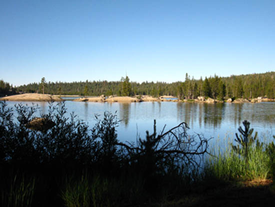
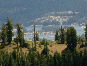
Lake AlpineA crystal blue lake filling a polished granite basin
Late July 2009. Elevation 7303 feet Lake Alpine has car campgrounds on its East and West Shores, the Tahoe to Yosemite Trail running past its East Shore, with the Pacific Crest Trail crossing Highway 4 fifteen miles to the East at Ebbetts Pass. |
||||
|
||||
The Lake Alpine Lodge Contact Information Address, Location on Road Map, Services, and People |
||||
Lake Alpine Resort 4000 Highway 4
209-753-6350
email |
 |
Local Transportation Note There is none. From the Pacific Crest Trail at Ebbetts Pass I hitch-hike West to Lake Alpine. People are very nice along Highway 4, but late and early in the hiking season we may have to wait a while between cars. When following the Tahoe to Yosemite Trail I establish my campsite on the East side of Lake Alpine, then walk down to the Lodge. |
||
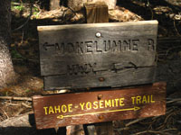
Tahoe to Yosemite Trail sign in Bee Gulch a bit North of Lake Alpine. Mokelumne River to the North, Highway 4 to the South.
|
||||
Highway 4 Lake Alpine Road Map |
||||
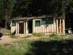
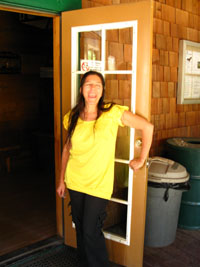
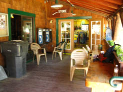
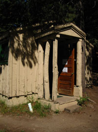
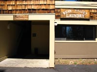
Physical The Lake Alpine Lodge is composed of a beautiful main lodge building containing the restaurant, bar, and store. Rental units are scattered around behind the main building, along with housing for some of the employees. There is also a building housing coin-operated showers as well as clothes washers and dryers that backpackers can use.
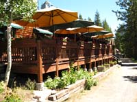
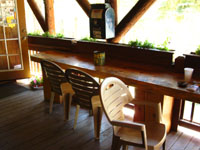
The Deck One of the features of the Lake Alpine Lodge is the Deck. A sliding glass door connects it to the bar on one side, and we overlook Lake Alpine on the other. Here we find fishermen, backpackers, tourists, Hunters later in the year, and lots of good conversation floating around, telling stories not even your mother would believe. It is a wonderful spot to relax and "take it all in" on the Lodge's Deck after backpacking in. Or a day of fishing, hiking, hunting, or whatever. The Deck represents the center Lodge's social and working environment, which is laid back, and very backpacker friendly. Note the mailbox and pay phones. Plenty of chairs. Quite a mix of people gather here, heavy on fishermen and car campers from all over California, our nation, and the world.
|
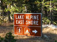
Backpacker Camping There is a backpacker campground on the East side of Lake Alpine. It is situated on the left side of the short paved road between where the Tahoe to Yosemite hiker exits Bee Gulch on Highway 4 along the East Shore of Lake Alpine to where the trail continues South through the Silver Trailhead. When we see the bathroom on the right we will shortly see the backpacker's camp on the left. The problem for me is that a campsite costs $15, which is just crazy, considering that camping in the National Forests is free, even without a backpacking permit. I've never seen a backpacker camping there. UPDATE: During 2011 a car pulled up, some folks pirate camped, and they departed early the next morning. About 50 yards upstream past the backpacker's camp (East, behind the backpacker's camp) is my little camp. It has a little fire ring, a nice flat for your sleeping bag, and good places to sit. Don't make fires. Too dry. There are bathrooms with a water tap across the paved road from the backpacker's camp that are open until mid-September. My camp behind the camp is about .75 of a mile East of the Lake Alpine Lodge. As Lake Alpine is our first rest and resupply point South of the Tahoe Basin, a span of between 4 and 7 days, depending on which trailhead we started from and our pace, I generally spend two nights at Lake Alpine. The first night is after I hiked in, and the second night is after a full day off the trail.
Sign pointing to the Silver Trail Head, as well as the Silver Valley and Pine Martin Car Campgrounds on the East Shore of Lake Alpine along Highway 4. There are numerous car campgrounds around Lake Alpine, which always appear full during Summer. There is the crappy & expensive backpacker's camp, and my pirate camp behind it. Lake Alpine Lodge has tent cabins, and I've urged them to set up a backpacker's camp area, where backpackers could throw down while soaking up some services, a shower, clean clothes, and their great breakfasts! |
|||
Lake Alpine Lodge
|
||||
Backpacker Resupply
Lake Alpine Lodge will accept your resupply package and hold it for your arrival for no charge.
Kim, the Lodge's most excellent manager, says that as UPS delivers the package to them for free, they will not charge backpackers. If Kim has to pick it up, as is the case with resupply packages sent through the US Postal Service, she will charge you for it. So with the money you saved on your free resupply, buy yourself a nice meal at the Lake Alpine Lodge!
NOTE Free Resupply Service is ONLY available when shipping your resupply by UPS ONLY |
 |
Resupply TWO RULES Kim, the Lake Alpine Lodge Manager, has two simple rules for resupplies:
The reason is that Tahoe Yosemite backpackers get lost in Summit City Creek and along the Mokelumne River, and do not show up for their packages. If Kim knows our arrival date and has an emergency phone number, she will check with your people then call in SAR.
I highly recommend that you call the Lake Alpine Lodge and speak with Kim about her current resupply preferences. (209)753-6350 |
||
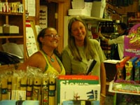
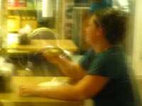
| Mel and Kim behind the counter at the store, as a nice Chinese Student worker stocks the shelves... | ||||
Resupply Address by UPS ONLY
4000 Highway 4 (209)753-6350
Lake Alpine Lodge Website
email
|
||||
Resupply Note I have found these items hard to come by at Lake Alpine, so I pack them in my resupply package.
|
||||
Other
|
||||
| Hot Food | ||||
Restaurant Expensive, but you just picked up a free resupply. Muir Ranch charges $50 to deliver your resupply, so have a big dinner of Lake Alpine's Fine Mountain Dining on your savings... Salad and Soup are always good, the steaks and burgers always great. |
Short Bar Menu The Lake Alpine Lodge sports a short appetizer/Bar menu that is a bit cheaper than the restaurant menu. |
Microwave food in the Store Burritos, ice cream, chips, candy and such.
|
||
The Lake Alpine Lodge restaurant is expensive, as are all High Sierra resupply spots. The added expense of Lake Alpine compared to other resorts and resupply spots is due to the owner's intentions to provide gormet-quality fine dining fare along the Sierra Crest. The result is we find the highest quality meat, seafood, and veggies are available at the Top of the Historical Ebbetts Pass Scenic Byway, up at the top of the Highway 4 corridor, where our favorite High Sierra trails pass by. To counterbalance pricing are large portions of this high quality fare. Backpacking bums like me and other low-wealth hikers will find the restaurant prices intimidating, but also find cheaper pricing on the bar menu.
|
||||
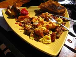 |
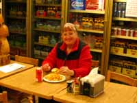
Killer Breakfasts Left: Delicious Corned Beef Hash with scrambled eggs, potatoes and lots of coffee and water Right: I ended up sharing my breakfast conversation and map with Phil and Jim Hurley, hunters up from Oakdale, 2013. You meet the nicest folks at the Lake Alpine Lodge. |
 |
||
|
Store
|
||||
Beverages Beer Juice Milk Soda |
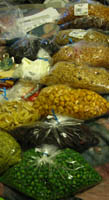
Food Not much suitable for backpackers. The store is meant to supplement the supplies of the car campers and fishermen from the nearby car campgrounds. The Bear Valley Store has more in the way of lightweight foods. |
Fuel I managed to scrape up some white gas with the help of the Lodge Staff, and especially Steve, but the store did not stock fuel.
|
||
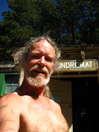
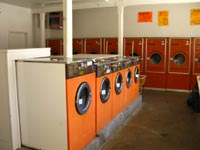
Laundry
|
||||
Showers I suggest including a small soap bar and a small bottle of shampoo in your resupply package. |
 |
|
||
 |
||||
shower and laundry building Get your supply of quarters in the store to operate the showers and laundry. |
clean clothes and a shower will feel good. Clothes are washing... Laundry Day on the Trail. |
Men's shower on right side of building, women's on the left, with the washing machines in the middle. | ||
The
|
||||
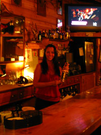
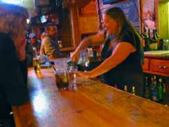
The Lake Alpine Lodge Bar is a good place to have a stiff drink, meet the locals, car campers, fishermen, while having a set of mini-burgers ("Sliders") with a cold beer. The bartenders and most of the staff at the Lake Alpine Lodge are drawn from the local area. The people who live on the Highway 4 corridor from Arnold, through Calaveras Big Trees, and up to Bear Valley and even across to Markleville are noted for their independent characters.
China Blue behind the bar keeping things rolling. |
 |
Let's Kick Back
Above: The patio between the Bar and Store is a great place to have a beer, write a postcard, enjoy some food, watch the lake, and talk with fellow backpackers, fishermen, and campers.
|
||
Deborah is the Coolest Bartender between Lake Tahoe and Mount Whitney. Stop in and buy her a beer! And Have one yourself, too! (Though Casey, the old cowboy/rodeo rider/horsepacker at Kennedy Meadow's Bar is a close second!!) |
||||
A few
|
||||
I generally arrive at the Lake Alpine Lodge in the early Afternoon, having hiked over Mount Reba from Camp Irene on the Tahoe to Yosemite Trail. First, I establish a campsite on the East Shore of Lake Alpine. I properly stash the remainder of my food, get water, and locate a nice place for my pad if it's late in the season and the mosquitoes have diminished. If not, I put up my tent. Then I walk down the paved lake shore path along Lake Alpine to the Lake Alpine Lodge. That's a lot different than the unmaintained trails we navigated North of here, and will encounter to our South! Very Relaxing... I check with Kim to see if my resupply has arrived, but do not yet pick it up. I will spend two nights at my campsite on the East Shore of Lake Alpine, and there are lots of bears trying to pick off the car camper's food. |
 |
 |
||
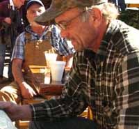
| The Boss, husband away on a job... | Cool Wait staff. Tip them well. | |||
 |
 |
 |
||
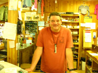
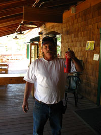
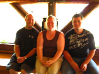
| Big Don keeps things moving at the store. | Steve is a heck of a dude. He keeps fixes things at the Lake Alpine Lodge, which is a heck of a job | Emilie, who keeps the cabins fresh and clean, and Jeremiah the Excellent Cook, at center and right. I can't remember the name of the guy on the right | ||
TYT
Miles
North and South
Miles
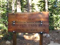
Lake Alpine North to... (SECTION IIA: ALL GUIDE PAGES) Carson Pass Trailhead
Carson Gap
South Upper Truckee Trailhead
Echo Summit Trailhead
Lower Echo Lake @ Echo Chalet Resupply
Meeks Bay TYT Trailhead
South
Our Next Section South on the TYT 34.57 miles
Remaining Distance South on the TYT 132.3 miles
The Southbound PCT 29.44 miles
|
Other
Lake Alpine Lodge was not stocking White Gas or other backpacking fuels in 2009. My solution was to carry the necessary fuel to get to Kennedy Meadows. I am hoping we can work out a white gas and fuel canister supply out of Lake Alpine. Lake Alpine Lodge was not stocking towels, small soaps and small bottles of shampoo for backpacker showers in 2009. I've hit them up to sell these items. In the meantime I pack little bars of travel soap and little bottles of shampoo into both my Lake Alpine and Kennedy Meadows resupply buckets. Kennedy Meadows has towels and soap, but you might want to pack yourself shampoo, a razor, and whatever else cleans you up.
In any case you've got to determine if fuel resupplies are available for your particular stove at each Resupply Spot. I cay call them and make sure:
Lake Alpine Lodge Kennedy Meadow Pack Station
|
High Sierra Lake Alpine |
||||||||||||||||||||
All
All
Comprehensive
|
||||||||||||||||||||
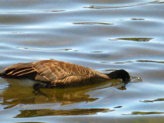
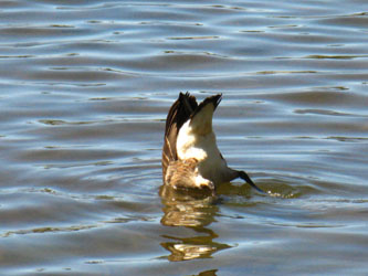
Scenic Splendors:
Canadian Geese Fishing
on
Lake Alpine
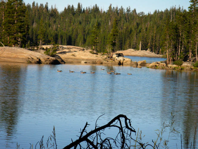 |
Lake Alpine in the morning with geese. This place is beautifully relaxing, especially taking FULL a day off here. |
Geese Fishing on Lake Alpine
 |
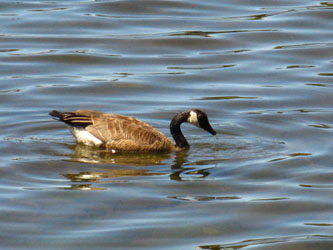 |
| Looking for fish | found 'em |
 |
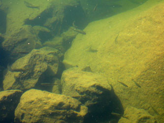 |
| Getting breakfast | Breakfast: Trout Fry |
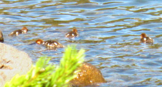
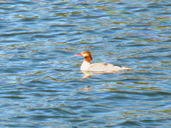
Mergansers Too
 |
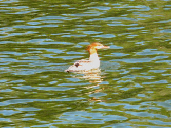 |
| Merganser chicks hunting and feeding near shore as I walk by | Merganser mom does not like me walking past |
 |
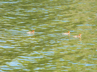 |
| Merganser mom calls chicks away while tracking me | The Merganser chicks respond to mom's call |
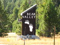
Bear Valley
Bear ValleyBear Valley is located on Highway Four 3 miles West of the Lake Alpine Lodge, and 26 miles East of Arnold. Arnold is the nearest full service city down the West side of Sierra Crest from Ebbetts Pass and Lake Alpine. Bear Valley has a good store with some lightweight foods, a Deli in the store which is excellent and priced for locals, along with two sports shops where you can pick up socks, sunscreen, and random items you may have forgotten in your resupply, or damaged on the trail. This map provides locations for all the resources I've identified in Bear Valley |
 |
 |
The Bear Valley Village Center is where the Store/Deli, the Post Office, and one of the sports shops is located. Follow Bear Valley Road about a quarter mile from Highway 4. The Bear Valley Village Center is the huge building on your right.
|
||
Bear Valley Services |
||
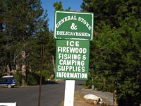
Bear Valley Store and Deli Bear Valley Village Center PO Box 5242 phone: 209 753 2842 "Your complete food service store. We carry fresh produce, fresh meats, liquor and wine plus film, drugs, and sundries, games and toys, camp fuels and fire wood. Our in store delicatessen serves fast and delicious breakfast and lunch sandwiches. We also can prepare trays for your parties." |
 |
 |
| The Bear Valley store and Deli | Susanna keeps it real in the store Working for the feds now? |
|
| I hung out at The Bear Valley Store and Deli for about 5 hours in late September of 2009. My main activity was eating. As Summer was ending and Ski Season had not begun, I was enjoying the company of Bear Valley locals. After eating all day, I tried to hitch back up to Ebbetts Pass, but only made it to the East Shore of Lake Alpine before dark. I ran by without stopping during trips through in 2010 and 12, only stopping here again in 2013, where I found a quiet scene. | ||
Rim Fire Effect, Sept-Oct 2013 Small buisness vital to support long distance High Sierra backpacking, such as the Bear Valley Store and Deli, suffered deeply from the Rim Fire of 2013. Fire danger and damage was expanded for hundreds of miles by the massive smoke plume, killing outdoor activiey and business up and down both flanks of the Sierra Crest. Most of these businesses are run by normal working class folks who depend on Summer profits to survive Winter. |
High Altitude
I never promote consumption or even acknowledge any validity for "consumer" identity or values, yet these folks need our commerce. Help local high altitude businesses as your means permit. Get out for an extra trip to the Sierra and spend some money. Stop for meals, buy a six-pack, and do a little high altitude shopping. |
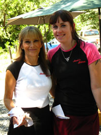
Denise Carter, owner of the Bear Valley Deli lives here for the beauty of the terrain. This beauty comes with physical and financial dangers, as the Rim Fire reminded us. Denise reminds us that the smoke has cleared and the cold beauties of Fall are spreading across the Sierra. Stop by and have a sandwhich and beer with Denise at the Bear Valley Deli. |
| The Bear Valley Deli offers lower cost fresth hot food for backpackers who cannot afford the restaurant at the Lake Alpine Lodge. | ||
Bear Valley Laundry The Laundry Mat is located directly West of the gas station/sports shop at the intersection of Highway 4 and Bear Valley Road. |
 |
 |
| The laundromat is like a bunker | ||
|
Bear Valley Village Center PO Box 5096 phone: 209 753 2844 |
I was able to resupply with sunblock here. Kira, who works in the store, is really nice. This shop is located in the Village Center, along with the Store/Deli and the Post Office. "Come to the Bear Valley Sport Shop in the commercial center for the local’s scoop on any of your mountain adventures. We offer the inside information and gear you need for day hikes, camping, running, swimming holes, off road-ing, biking, and high sierra lounging. Of course, we have alpine ski gear available for deeply discounted prices for those of you who are bargain hunters. We also have a mountain boutique full of affordable summer clothing to fit any activity’s needs and a good selection of gifts. Come visit us!" |
|
Bike Shop-Gas Station Bear Valley Adventure Company 1 Bear Valley Road PO Box 5120, Bear Valley, CA 95223 phone: 209 753 2834 |
This shop is located at the intersection between Highway 4 and Bear Valley Road. I bought a pair of acceptable backpacking socks here, when one of my pairs came apart on the trail. |
|
Post Office Bear Valley Village Center 3 Bear Valley Road Bear Valley. CA 95223 phone: 209 753 2898 |
I had a nice conversation with Rick, who runs the BV Post Office. I really suggest sending your resupply package to the Lake Alpine Lodge via UPS. Rick's post office is pretty small, and it would be a hassle for him to store resupply packages there. But he will, even though Kim will have UPS deliver our resupply packages to Lake Alpine, which is much closer to the trail. |
|
| Informative Websites |
Bear Valley Business Association: local guide Bear Valley Adventure Company
|
|
Arnold
| Arnold Full Regional Services |
The nearest full-service town is Arnold, located 29 miles down the Western Flank of the Sierras from the Lake Alpine Lodge on Highway 4. If you break your leg, you will end up in Arnold. But not to worry, Arnold is a fine town full of very nice people. This is the place you can find a full grocery store, a doctor, pharmacy, gear and clothes, as well as a wide range of dining and lodging.
Good Food in Arnold There are two excellent cafes that I like to eat at in Arnold. Both serve excellent breakfasts and lunches. If you have further recommendations, shoot me an email, or post it on the comments feature of the Lake Alpine/Bear Valley Forum.
Suzie's Diner
Just Delicious Cafe
Arnold Restaurant Guide
Outdoors Shop Sierra Nevada Adventure (209) 795-9310
Mountain Art It's there... I met a bunch of really nice people in 2009 when I hitch-hiked down the mountain from Ebbetts Pass, first to the Lake Alpine Lodge, then to Bear Valley, and finally all the way down to Arnold. The Local Life An exhilarating conversation was had with Mr. William Poulson, a fine artist, lover of Wilderness, and a good guy who runs Poulson Glass Studios with his wife. I'm still glad that Bill picked me up hitch hiking! Thanks Bill! Their mailing address is Poulson Glass Studios 209 795 5365 Stop by their studio and saw hello! Bill just loves the mountains, the wilderness, and gave me a great conversation, as well as a ride. Their studio is located close by Suzie's Diner, also in the Cedar Center by El Dorado Savings. Poulson Glass is across from the Savings to the West, while Suzie's Diner is directly behind El Dorado Savings. (http://www.williampoulson.com/William_Poulson/Welcome.html) Hitch hiking to Arnold and back: You meet the Best People in the Mountains!
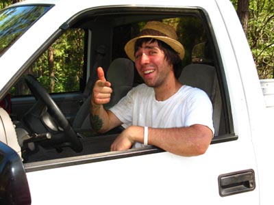
You meet the best people in the mountains, and the Highway 4 corridor is no exception. This is Bryan, and you'll be lucky if you meet him when you are hanging around Arnold. Hey Bryan! Thanks for the ride, Dude! |
Next |
Our next Resupply heading South from Lake Alpine will be Yes! It's time to go visit the cowboys, horsepackers, hunters (If you are packing through late in the Season), and the many fine people who have come up from the valley.
Distance South to Kennedy Meadows Pack Station Resupply
Distance South to Tuolumne Meadows Resupply
Distance North to Echo Lake Chalet Resupply
|
Differences
|
Index |
High Sierra
Lake Tahoe Region Resources and Transportation
Lake Alpine Lodge and Bear Valley
Red's Meadow and Mammoth Lakes
|
High Sierra
|
| High Sierra Trails | High Sierra Topics |
Anyone can post text comments in the existing forums, but only members can post up new topics, along with images, maps, and formatting.
If you have experiences, comments, questions, or pictures and videos about resupplying on the Tahoe to Yosemite or Pacific Crest Trails at Lake Alpine Lodge or Bear Valley on Highway 4, post up here as an unknown hiker or as a member:
Backpacking Preparation / Resupply
Lake Alpine Resupply Forum
Trailhead
Contact
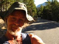
Alex Wierbinski

Backpacking Lake Tahoe to Mount Whitney
Your guide to the High Sierra Crest, including the Tahoe to Yosemite, Pacific Crest, and John Muir Trails
