


Backpacking
Lower Blue Lake to Raymond Peak
Hiking
The Pacific Crest Trail
across the
Blue Lakes Road
Four
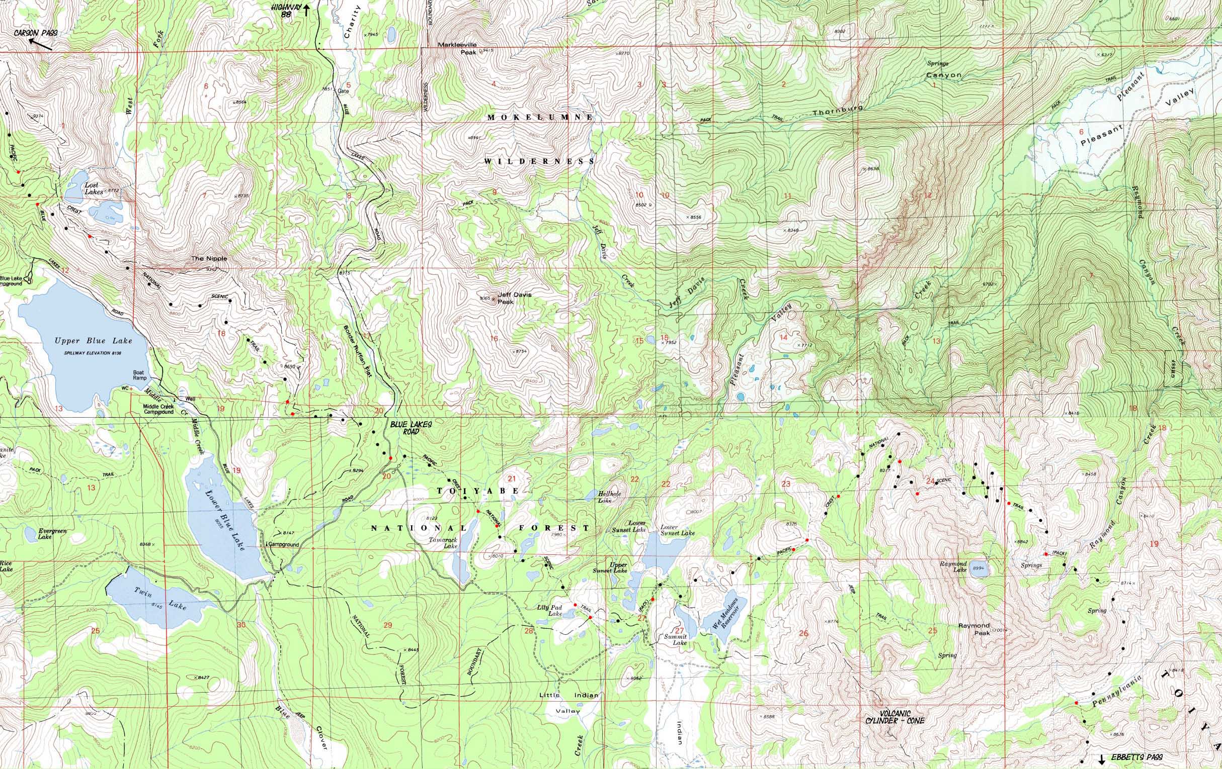
7.5 minute USGS Backpacking Topo Maps, Mokelumne Wilderness, Toiyabe National Forest

| Pacific Crest Trail Topo Maps and Mileages |
Trail Guide | Tahoe to Whitney Indexes |
More PCT Miles and Elevations |
Weather, Map Data | ||||||||||||||||||||
| PCT Maps Index Lake Tahoe to Highway 4 |
PCT |
North PCT Carson Pass to Lost Lakes |
South PCT Upper Sunset Lakes to Ebbetts Pass |
Miles and Elevations Carson Pass to Ebbetts Pass |
TYT-PCT SOUTH Mokelumne Wilderness Backpacking Map |
Trail Section Carson Pass to Ebbetts Pass |
Guide Page Forrestdale Divide to Blue Lakes Road |
Guide Page Blue Lakes Road to Mokelumne Wilderness |
All Miles Tahoe to Whitney |
Section Maps Lake Tahoe to Highway 4 |
All Maps Tahoe to Whitney |
Echo Summit to Carson Pass |
Carson Pass to Ebbetts Pass |
Ebbetts Pass to Sonora Pass |
Sonora Pass to Tuolumne Meadows |
|||||||||
| click colored dots on map below for related trail guide pages | ||||||||||||||||||||||||
PCT MILES
Lost Lake Junction to Blue Lakes Road: 3.64 miles
Blue Lake Road to Campsite on Stream North of Raymond Peak: 8.09 miles
Campsite to Pennsylvania Creek: 6.68 miles
18.41 miles total
| MAP North Carson Pass to Lost Lakes |
click red dots | MAP South Upper Sunset Lakes to Ebbetts Pass |
|
| MAP North Carson Pass to Lost Lakes |
click red dots | MAP South Upper Sunset Lakes to Ebbetts Pass |
Mapology |
||||
MAP NOTE What's important for our general reference purpose is that each side of a square is 1000 meters, or a Kilometer. From my point of view that is 1093.6 yards or .62 of a mile. Diagonal: 1414.22 meters, if my trig is correct. That converts the diagonal distance into 4,639.8 feet or .88 of a mile.
|
Carson Pass
Highway 88 Road Map
Mapping |
|
Mileages and Elevations
Backpacking Permitting AuthoritiesEl Dorado National Forest National Forest Contacts via TW: El Dorado NF National Forest web page: El Dorado NF Wilderness Area: Mokelumne Ranger Districts: All
Toiyabe National Forest National Forest Contacts via TW: Toiyabe NF National Forest web page: Toiyabe NF Wilderness Area: Mokelumne Ranger District: Carson Ranger District |
USGS Map Name NE Map SW Map SE Map Compass Offset
Scale: 1:24 000 Contours: 40 Feet
Comments? Questions?
Physical location |
MAP North: Carson Pass to Lost Lakes MAP South: Upper Sunset Lakes to Ebbetts Pass
| Elevations | More Information | ||
South of Blue Lakes on the Pacific Crest Trail: Around an 8000 foot average |
Trail Guide Section Trail Guide Page |
||
Map CreditThanks, USGS! |
U.S. Geological Survey, Department of the Interior: Move the Map to the Sierras. Select size of Maps you wish to locate. Click "Mark Point" on map to see the USGS map grid of the selected map scale. USGS Topographic |