


Relief Reservoir to Brown Bear Pass
into the
Emigrant Basin
Backpacking Map
Tahoe to Yosemite Trail through the Emigrant Wilderness
Four 7.5 minute USGS Topo Backpacking Maps

Maps |
TYT |
TYT |
Miles |
Trail Guide |
Trail Guide |
BIG |
Highway 108 |
Click |
Trail Guide |
all maps |
Weather Emigrant Wilderness All Weather High Sierra |
Resupply |
Topo Hiking Map
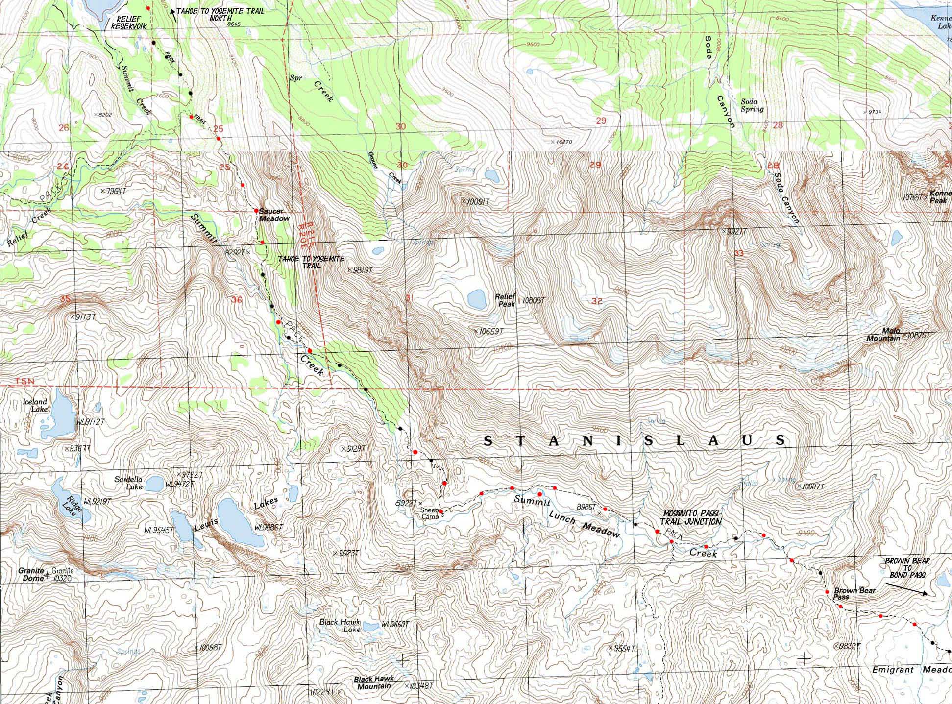
Summit Creek to Brown Bear Pass via Saucer Meadow, Sheep Camp, and Lunch Meadow
| NORTH TYT Kennedy Meadows to Relief Reservoir |
Click RED Dots for TRAIL GUIDE ENTRIES |
SOUTH TYT Emigrant Basin to Bond Pass |
The
Tahoe to Yosemite Trail
Climbing
to the
Sierra Crest
|
| The Trails Come Together at, and diverge from, Sonora Pass: 30 minute Carson Iceberg & Emigrant Wilderness High Altitude Trail Map |
| NORTH TYT Kennedy Meadows to Relief Reservoir |
Click Red Dots & MAGNIFY these MAPS! |
SOUTH TYT Emigrant Basin to Bond Pass |
and
Pacific Crest Trails
across
Emigrant Wilderness
into
The Top of Jack Main Canyon
|
| NORTH TYT Kennedy Meadows to Relief Reservoir |
MAGNIFY THIS MAP! 100% Size Map Click Red Dots |
SOUTH TYT Emigrant Basin to Bond Pass |
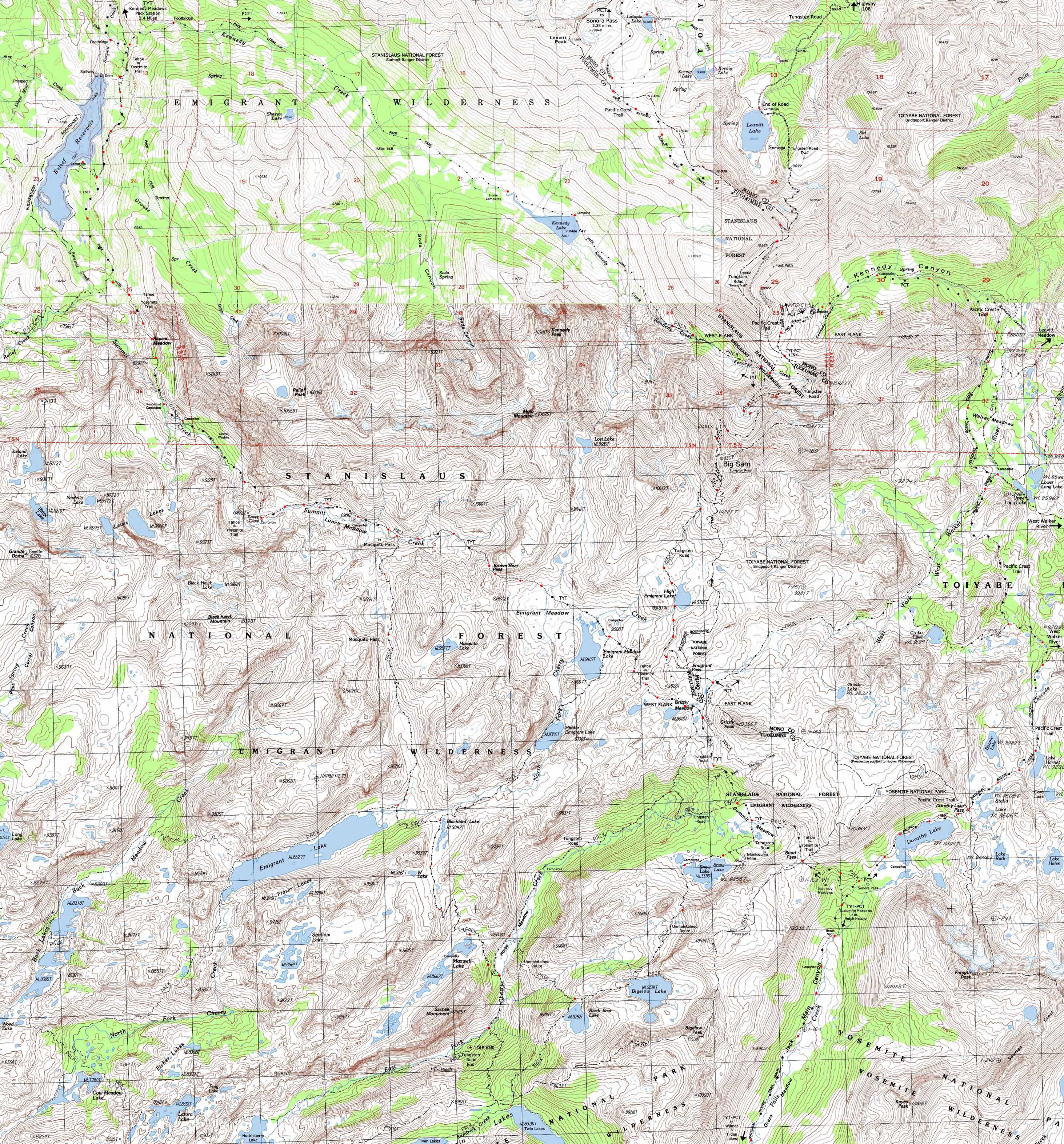
30 minute Carson Iceberg & Emigrant Wilderness High Altitude Trail Map
Location |
||||||
Main Features Our 10.92 mile long climb up to Brown Bear Pass from the Gate at Kennedy Meadows Pack Station bends Southeast just past the halfway point, which is where our Southbound trail Tees out and turns Left at the trail junction off the Southeast shore of Relief Reservoir. We turn Left with the Tahoe to Yosemite Trail route, to the Southeast, to begin the climb funneling us up and into the center of the mouth of a great valley dividing an amazing interface between volcanic and granite terrain roughly marked out by the route of Summit Creek up to its headwaters on the North flank of Brown Bear Pass. To our Left dark red volcanic terrain dominates the Northern flank of the canyon, rising up to the hulking mass of Relief Peak. To our South the shining granites of Granite Dome's magnificant peak and its associated formations emerge each hard step we take climbing higher out of cool forests. South of Saucer Meadow a flat section between the granite and volcanic terrain opens up some excellent scrambling opportunities for access to Granite Dome and its scattering of lakes. At the end of this segment of trail, as we are climbing towards Brown Bear Pass, expansive views of this striking granite-volcanic interface opens up with our increasing altitude. Our view looking up at this different colors and textures of this interface as we hiked the lower segment of trail is completed by our overview of this striking terrain as we approach Brown Bear Pass. This grand interface lays out a clear chapter of geological history at our feet. The trail junction over Mosquito Pass situated between Lunch Meadow and Brown Bear Pass hikes us over a low pass to Emigrant Lake. The trail option over Mosquito Pass opens up nice backpacking loop options around the Emigrant Basin. Emigrant Lake is the third lake in the series of lakes descending Southwest from Emigrant Meadow along the North Cherry Creek within a stunning granite valley. Emigrant Meadow lays on the South side of Brown Bear Pass. We can loop back to Summit Creek by threading our route through Mosquito and Brown Bear Passes. Or we can push further Southeast beyond Emigrant Lake before we turn back towards Brown Bear Pass. The map above lays out our potential routes into and out of Emigrant Basin along both the Tahoe to Yosemite and Pacific Crest Trails. Hike one route into the Emigrant Basin, and the other out. Hike on over Mosquito Pass to Emigrant Lake. Now we have even more options to loop back to Summit Creek. First, to hike a nice loop back to this junction via Brown Bear Pass. From Emigrant Lake hike up North Cherry Creek past Blackbird, Middle Emigrant and Emigrant Meadow Lakes to connect with the TYT in Emigrant Meadow. Second, continue Southeast past Blackbird Lake and Maxwell Lakes to Horse Meadow. Climbing out the top of the canyon above Horse Meadow leads to Grizzly Peak. It is a short hike Northwest to Brown Bear Pass, and another potential return route to Kennedy Meadows. Check out route options on the map above and on this 30 minute map: 30 minute
Mapology What's important for our general reference purpose is that each side of a square is 1000 meters, or a Kilometer. From my point of view that is 1093.6 yards or .62 of a mile. Diagonal: 1414.22 meters, if my trig is correct. That converts the diagonal distance into 4,639.8 feet or .88 of a mile.
top of page |
Mapping, Mileage, |
|
Map Notes The USGS 7.5 series covering this section of Emigrant Wilderness have a series of errors. These errors are not on the maps themselves, but in naming the order of maps. Tower Peak is the correct map to the Southeast of the Sonora Pass map, Emigrant Lake is the map to the South of the Sonora Pass map. All the maps are present and accessible, but the order is screwed up. The map information to the Right lays out the proper orientation of this series of maps to each other.
Backpacking
|
Northwest Map
Northeast Map
Southwest Map Name
Southeast Map Name
Compass Offset
125% Size Map |
NORTH TYT Kennedy Meadows to Relief Reservoir SOUTH TYT Emigrant Basin to Bond Pass
| Elevations | More Information | ||
Trail above Relief Reservoir Sheep Camp Brown Bear Pass |
Trail Guide, Section: Highway 108 to 120 |
||
Map Credit |
U.S. Geological Survey, Department of the Interior: The USGS Move the Map to the Sierras. Select size of Maps you wish to locate. Click "Mark Point" on map to see the USGS map grid of the selected map scale. USGS Topographic |