

High Sierra
Backpacking
Trail Guide
Forums
Sierra
Weather
WeatherNotes Northern
Sierra Weather
Gear
The Tahoe to Yosemite Trail
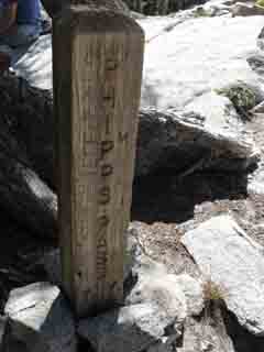
Backpacking South off Phipps Pass
Hiking out of the Meeks Bay Trailhead on The Tahoe to Yosemite Trail
Languages
Trail Skills
Mountain
Safety
Food
Planning
Trail Arts
More
Information
Social
| Trail Guide Section INDEX |
North |
South TYT PCT-TYT TRT JUNCTION |
Miles & Elevations |
Miles & Elevations INDEX |
Lake Tahoe Basin Management Unit PERMITS |
|
8.88 miles South from Meeks Bay Trailhead. 19.83 miles South to Echo Lake Trailhead.
Both flanks off Phipps Pass have stunning views of different aspects of the beautiful terrain in the Desolation Wilderness along the Western Shore of Lake Tahoe.
|
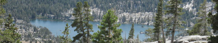
Views from the Top The North Flank of Phipps Pass (previous guide page) puts us between the two amazing granite ridge arms descending Southeast off Phipps Peak. From the North Flank of Phipps Pass we had grand views East-Southeast. We could see the North Shore of Fallen Leaf Lake through the gap between the Northeast flank of Maggies Peaks and the Southeast Flank of Peak 9195. It is through this gap where this whole basin holding the Velma Lakes below us drains through Eagle Creek into Lake Tahoe via Emerald Bay. Phipps Pass to Heather Lake Though these ridge arms descending off the North side of Phipps Peak somewhat limit the scope of our views along the horizon and to the Southeast, these same ridge arms blocking our views are the view. Seeing the rock wall composing the sheer face of the ridge arm under Peak 9195 is itself worth the hike in. The Basin Southeast of Phipps Pass Now we can see the Southwest side of the basin containing Velma Lakes and a scattering of small lakes. We can see that the Southern side of the basin is walled in by the great rising ridge crest of Maggies Peaks, bending Southwest up to the base of the massive ridge arm descending North from the Northeast flank of Dicks Pass. Just behind this near line of mountains featuring Maggies Peaks and Dicks Peak we see Tallac Peak rising substantially higher. Our TYT route climbing South out of the basin below takes a unique line. Our route puts us on the Southeast corner of Middle Velma Lake. From the middle Bayview Camper Flat junction located on the Southeast corner of Middle Velma we point ourselves South to Dicks Pass on a line between the ridges running North from Dicks Peak and the ridge running North from Dicks Pass. The ridge extending North from Dicks Peak is the North wall of Rockbound Valley. We need to keep an eye on the maps to get a good picture of this complex terrain. Meeks Bay to Echo Summit
We climb the West flank of the ridge arm extending North from Dicks Pass up through the narrow valley sheltering Fontanillis and Dicks Lakes on our way up to Dicks Pass. Here at Phipps Pass we are overlooking this scene from the great mass of the Phipps Peak Massif, which hems in the North side of the beautiful Velma Lakes Basin below. Draining Northeast
Draining West Maggies Peaks marks the South and Eastern limits of the basin holding the Velma Lakes, and dominates our view to the Southeast. But Maggies Peaks is not the main terrain feature we can see from our perch up here on the South Flank of Phipps Pass. Outside of the basin holding the Velma Lakes and to the Southeast of Maggies Peaks' long crest line Mt. Tallac's substantial summit towers above the South end of the line of Maggies Peaks bending ridgeline. Heading South off Phipps Pass bring us down a couple quick miles along long gentle meandering wide switchbacks to the trail junction with Pacific Crest and Tahoe Rim Trails, where our view is again submerged under forest cover. Let's do some numbers for the upcoming basin. Post up Your Notes on this fine terrain.
|
South of Phipps Pass
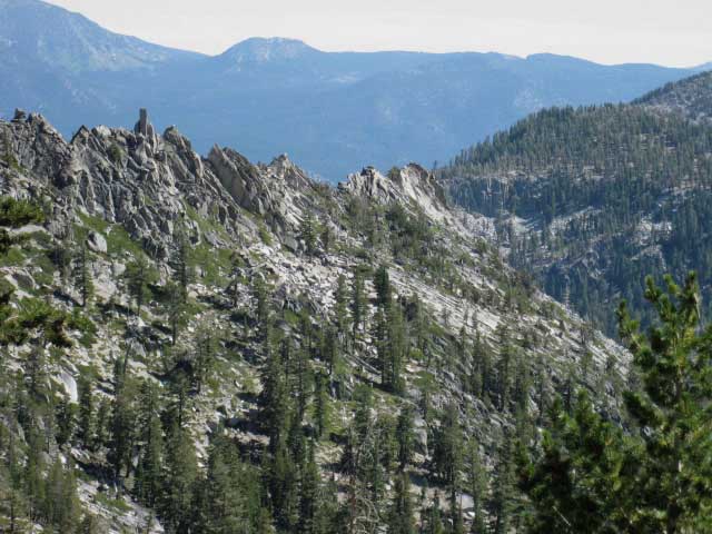 |
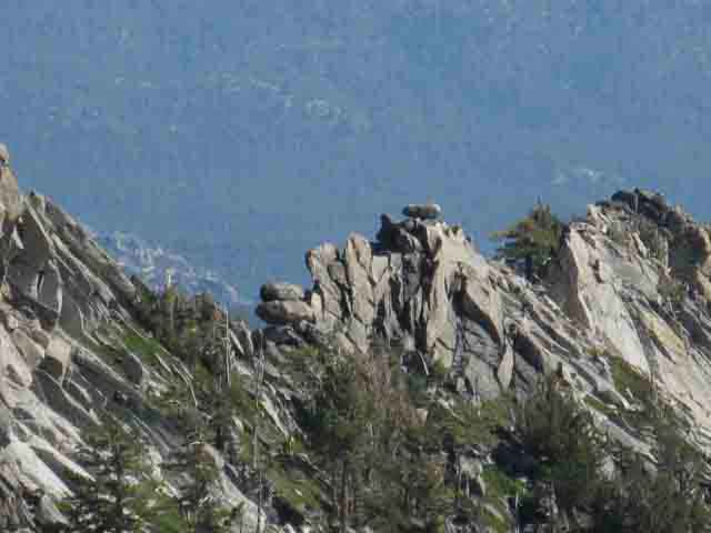
Hiking South of Phipps Pass looking East-Southeast, to our Left. The razor-backed ridge dropping down from the near Left of the image is the South side of the South ridge arm bracketing Grouse Lakes, rising above their South shores. Phipps Pass is located where that ridge merges into Phipps Peak, off the Left edge of the image above. We have just hiked South across Phipps Pass. On the horizon we can see Freel Peak rising out of the background Left with the much lower Peak 9647 rising on its Right side. The Northwestern shoulder of Maggies Peaks rises in the middle-distant Right side of the image, rising above Eagle Lake, which is not visible way down at the base of this flank. Phipps Pass to Heather Lake |
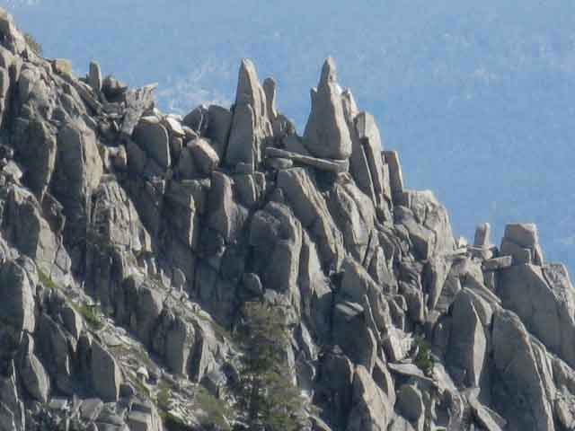
Details of the Southern Ridge Arm Descending from Phipps Pass
 |
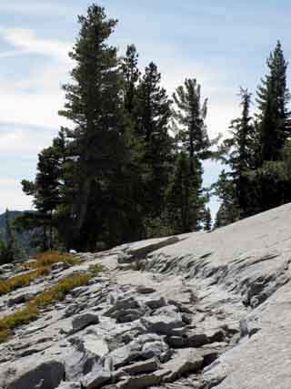
SHATTERED GRANITE RIDGELINE Most rock shattered by glaciers was taken up into the glaciers themselves and subsequently deposited further down the mountain as "erratics" during the melt. That did not happen to the shattered rock here, which still sits, shattered, in its original position, being gradually pried apart by the forces of erosion and plant growth. |
FU Rock
Ya Gotta Love Nature...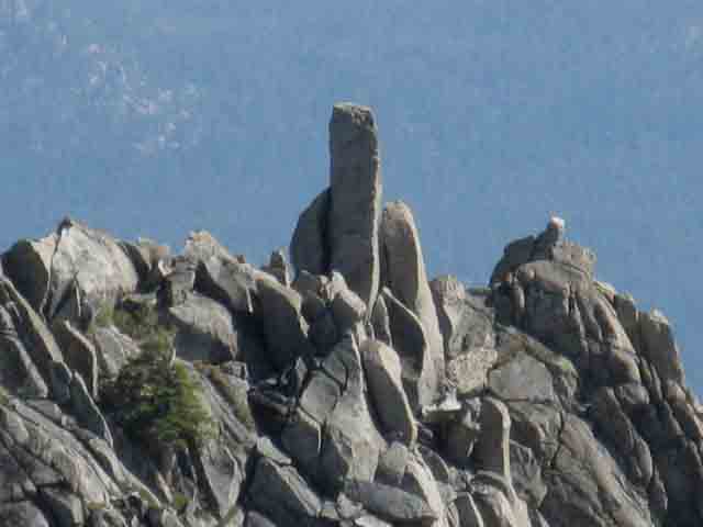 |
Nature has a message for us...Read between the lines... |
Balancing Act
 |
Razor Back Ridge with a series of delicate balancing acts. Amazing and Beautiful. Sweet sheets of razor thin granite. |
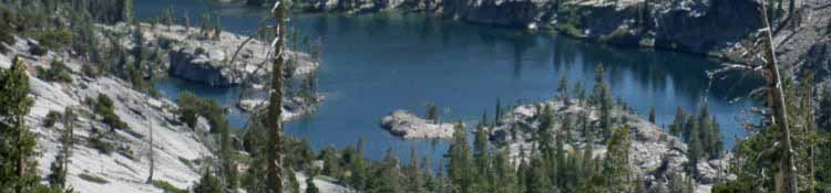
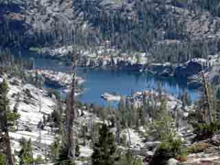
South Side of Phipps Pass view of the Velma Lakes below Maggies Peaks with Mt. Tallac rising over Maggies Peaks' long crest line
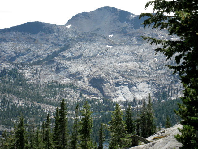 |
Maggies Peak in foreground with Mt. Tallac in background. Lower Velma Lake is visible at base of rock face. Viewed from South Flank of Phipps Pass. Phipps Pass to Heather Lake |
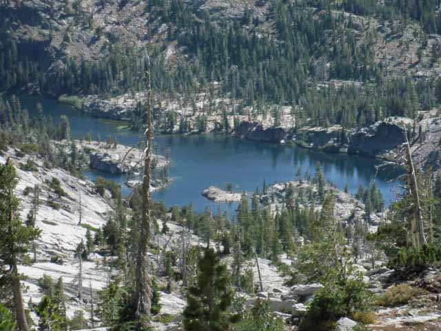
Lower Velma Lake
 |
|
| Above: Lower Velma Lake from the South side of Phipps Pass. | |
 |
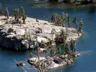 |
| Lower Velma from the South side of Phipps Pass |
|
Middle Velma Lake
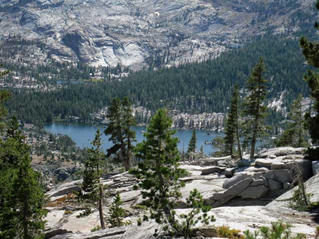 |
Upper Velma Lake visible in distant Right behind and slightly above Middle Velma Lake. |
Middle Velma Lake Detail
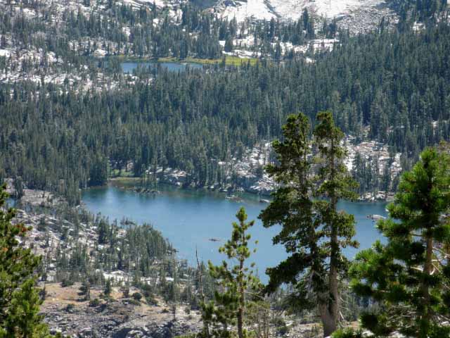 |
Middle Velma with Upper Velma Lake in background. |
Middle Velma Lake
| The combined routes of the Tahoe to Yosemite, Pacific Crest, and Tahoe Rim Trails all hike from Right to Left along the line of trees above the rock composing the far shore, the South Shore of Middle Velma Lake. |
 |
The first of the three Bayview-Camper Flat trail junctions we Southbound hikers encounter is on the far right side of the lake. We Southbound TYT hikers turn Left, to the East-Southeast. Turning West at this junction leads to Camper Flat in Rockbound Valley. Central and South Desolation Wilderness I'm planning on taking break approaching the junction in one of the fine spots looking across Middle Velma Lake. Snacks, maybe some coffee, and definitely filtering some water for the hike up to Dicks Pass from there. |
Hiking South
from
Phipps Pass
Trail, Trail Work |
|||
 |
 |
||
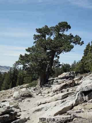
| Trail work and juniper, South side of Phipps Pass, Desolation Wilderness. | Massive trail work, South side of Phipps Pass. | ||
Off the Southwest Flank of Phipps Peak Phipps Pass to Heather Lake Hikers turning North off the TYT at this upcoming trail junction with the PCT-TRT may find the detailed map below-Left of Sugar Pine State Park to the North of Desolation Wilderness helpful. The full Desolation Wilderness Map linked to below Right gives us a view of the Northern and Western Boundaries wrapping around Desolation Wilderness.
We can see the current route was laid out to prevent the erosion the previous straighter, more direct route down the Southwest Flank of Phipps Peak created. 30 Min North The 1976 Placerville USGS 30 minute map shows the route of the TYT on a very different line to the PCT-TRT trail junction, rather than its current route wrapping around Phipps Pass, then taking long S-turns down to the PCT-TRT junction. That old route would be the basis for a cross country scramble for the more |
|||
 |
|||
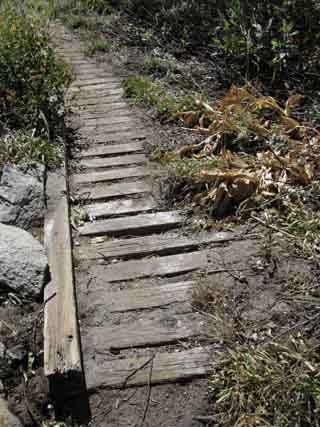
ARMOURED TRAILS The wood frame will let the moisture flow down mountain while retaining some of the soils that would normally erode away due to hikers damaging this moist area. Fragile soils are a problem for trails even in remote wilderness areas. The massive use of Desolation Wilderness makes the massive wooden armoring of these fragile segments of trail wise. |
|||
Middle Velma Lake from South side of Phipps Pass
Desolation Wilderness
Phipps Pass
|
The Big View |
||||
Hiking PlanSegment to Segment As we are sitting on the top of one pass, in this case Phipps Pass, I find it helpful to measure the distances and elevations to the next pass we have to cross. Our next pass to the South is Dicks Pass. These point to point evaluations of our High Point to High Point segments give valuable information about the nature of our upcoming hiking from low point to low points as well, which should give us some feedback as to how our experiences crossing it are affecting us and our evolving overall trip plan. Hiking Plan Questions In this case our next pass is Dicks Pass. The most basic and important information for backpackers are the miles and elevations of this segment of the Tahoe to Yosemite Trail between Phipps Pass and Dicks Pass. Let's do it. It's 7.95 miles between Phipps and Dicks Passes. We drop 880 feet over 3.44 miles from Phipps Pass to Middle Velma Lake. Middle Velma Lake is the low point between the passes. From Middle Velma Lake we climb 1430 feet over 4.51 miles to Dicks Pass. Answers
TESTING THE HIKING PLAN Next is considering the locations of the upcoming streams, lakes, and premium views where we will take our series of breaks, our lunch breaks, and get water. We can sketch out how well our "daily hiking plans" are working so far, and use these points of analysis and assessment to project how our plans will work out against how we will feel at the end of the day. Contrasting these terrain, distance, and elevation observations against how we feel, how much energy we have, and finally, contrasted against the difficulties of our required miles for this day's hiking give us a very real assessment of our status. The pertinent question is, "Are we moving towards our daily miles and our daily destination with strength? With weakness?" We need to know if we are getting stronger or weaker as each mile and each day passes. We are thinking about how each step executing our daily hiking plan determines both the daily and overall validity of our plan. Projecting that plan on the upcoming terrain foretells how radically we are going to have to adjust our expenditure of energy to reach our daily and overall goals as our trip evolves. On a clear day we can see the last steps of our trip from its first. We use this clarity to adjust the nature of each step we take down the trail to keep the to keep our steps clear of self-created obstacles. Self-destruction hiking down the trail is the ultimate self-created obstacle. Sitting at Phipps Pass at noon means that we are thinking of camping at Fontanillis or Dicks Lake as the day draws to a close. I like to divide up the trail like this, by miles and elevations between mountain passes when I plan a trip. We keep our hiking plan tuned to the nature of the reality on the ground by updating it as we execute it.
THE INTERNAL YARDSTICK Our daily mileage trends must be compared with how our physical condition is trending. This indicates if disaster or delight is approaching us further down the trail, and help us properly adjust our hiking plans to mitigate weaknesses and enhance strengths. Plan our days off for optimal recovery to gain strength. Would a half-day off at a beautiful high elevation lake allow our altitude acclimation to "catch up," not to mention pushing down rising fatigue? A half-day of fishing may very well be the solution, the "fix" for a ratty fatigue lurking at the fringes of our hike. If we start falling behind plan we will have to start extending our hiking days by starting earlier in the day or hiking later into the day, or both. This is no problem. I generally don't walk from Dawn to Dusk until I've been on the trail a few days, so I always anticipate doing more daily miles as the trip progresses. And, less miles at the beginning of the trip. If we start running ahead of schedule or our "battery" starts running down excessively, it may be wise to weave a half-day or full day off into our hiking plan.
|
North TYT: N. side, Phipps Pass South TYT: Pacific Crest Trail/Tahoe Yosemite trail junction
Backpacking South |
||
Our next trail junction South on the Tahoe to Yosemite Trail from Phipps Pass will be where we join up with the combined Pacific Crest and Tahoe Rim Trails. This junction lays 2.62 miles South of, and 720 feet down in elevation from Phipps Pass. During this gentle descent that first wraps around Phipps Peak, we are treated to delightfully different aspects of the view of Velma Lakes, Maggies Peak, and the great granite crest lines leading to Dicks Pass. This is not a high-stress steep descent. We enter increasing tree cover and the trail softens a bit, all refreshing after the climb up to Phipps Pass and the exposure crossing it.
Next guide page South |
Backpacking Trail Guide |
 |
Backpacking Trail Guide |
Backpacker ForumsGeneral Backpacking TopicsPost it on
The view from Phipps Pass, Desolation WildernessAdd your experiences, comments, or pictures about thisSection
|
TYT North: N. side, Phipps Pass TYT South: PCT/Tahoe Yosemite Trail junction
Trailhead
Contact
Alex Wierbinski

Backpacking Lake Tahoe to Mount Whitney
Your guide to the High Sierra Crest, including the Tahoe to Yosemite, Pacific Crest, and John Muir Trails
