


North Yosemite Backcountry Topo
Backpacking Map
The Combined Pacific Crest and Tahoe to Yosemite Trails
Topo Hiking Map covering
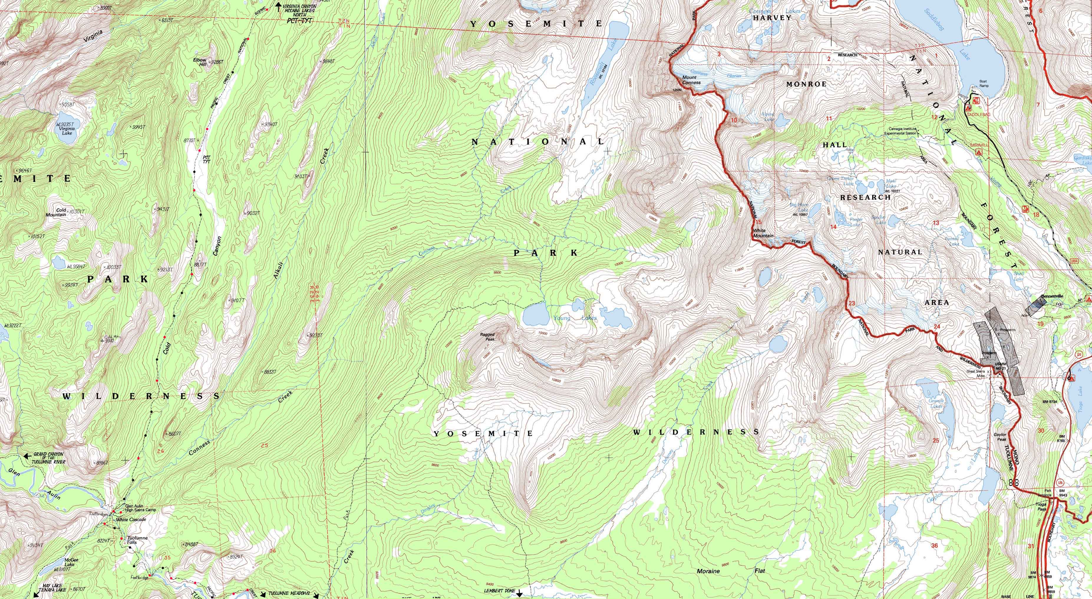
McCabe Lake trail junction down Cold Canyon to Glen Aulin
7.5 minute USGS Backpacking Map

Hiking Maps |
Hiking Map PCT-TYT |
Hiking Map |
PCT |
TYT |
Trail Guide |
Trail Guide |
30 min |
|
Click RED Map Dots for links to Trail Guide Pages |
Mountain |
Permits | map information |
Combined Pacific Crest and Tahoe to Yosemite Trail routes across the North Yosemite Backcountry
North: Miller Lake to McCabe Lake Click Red Dots South: Tuolumne Meadows Region Hiking Map
Grand Canyon of the Tuolumne River&
North Yosemite Hiking Map
|
&
North Yosemite Hiking Map
North: Miller Lake to McCabe Lake Click Red Dots South: Tuolumne Meadows Region Hiking Map
Location |
Main Features We are dropping like a rock down through the expansive meadows filling the upper segment of Cold Canyon once we finish the moderate climb out of Virginia Canyon hiking just a short ways South from the McCabe Lakes junction. Hiking a shory ways past the Big Rock (you will recognize it when you see it...) we come to the end of the expansive meadows we've hiked for miles coming down upper Cold Canyon, where we depart meadows to cross a ridge arm that the Cold Canyon Creek goes around. Click the red dots on the trail maps to see that location on the trail guide. Click the black dotted routes on the large-scale 30 minute maps to see these underlaying detailed 7.5 minute maps. |
Mapology |
||||
MAP NOTE What's important for our general reference purpose is that each side of a square is 1000 meters, or a Kilometer. From my point of view that is 1093.6 yards or .62 of a mile. Diagonal: 1414.22 meters, if my trig is correct. That converts the diagonal distance into 4,639.8 feet or .88 of a mile.
|
Mapping, Mileage, |
|
Yosemite Permits I have not yet written the Yosemite National Parks permit page. But I will offer some advice. (Update: Yosemite Permits) I still offer this advice as valid: Walk into Yosemite. Don't even mess with getting permits there. Want to hike the JMT? Start at Sonora Pass. Drop down to the Valley backwards on the JMT once you arrive at Tuolumne Meadows, then reaccquire the JMT in Lyell Canyon via Voglesang. Or start into Rancheria Creek down Kerrick Canyon from Twin Lakes on Highway 395 a few miles West of Bridgeport. Yosemite Permit Problems Solved. Yes, I know that may not solve your permit problem. But it is a start. We could start into Yosemite from closer trailheads located on the East flank of the Sierra in the Hoover Wilderness, but we may well face the same problems with reservations and quotas that we encounter in Yosemite. Thus I prefer entering from further North, such as through Emigrant Wilderness, though the Hoover Wilderness trailheads are a popular alternative to beginning backpacking trips out of Yosemite Trailheads.
|
Topographic Maps Information Map Tioga Pass, Calif, 1994, USGS 7.5 minute Topographic
scale Contours
Compass Offset Map Magnetic North is 14 degrees 30" East of True North.
Backpacking permitting authority National Park Wilderness Area Physical location |
topo hiking map North: Miller Lake to McCabe Lake topo hiking map South: Tuolumne Meadows Region Hiking Map
| Elevations | Trail Forums Hiker Feedback |
More Trail Guide Information | |||
McCabe Lake Junction Big Rock in Cold Canyon Glen Aulin High Sierra Camp |
Trail Forum Section Trail Forum Page |
Trail Guide Guide Pages and Hiking Maps Index Trail Guide |
|||
Map Credit |
||
U.S. Geological Survey, Department of the Interior I love the USGS, as you can see from the Tahoe to Whitney Maps. I also dig the NWS, as you can see from our Weather Page. We gotta know the terrain under our feet, and the weather in the sky. These are the basics. In that spirit, let's set you up with the USGS maps sufficient to plan and execute your High Sierra Backpacking Trip with a set of custom backpacking maps. In fact, we can use the USGS to set us up to plan and hike anywhere in the US of A. Move the Map to the Sierras. Or your favorite backpacking spot in the US of A. Navigate the map to the area you wish to locate maps. Click "Mark Point" in the options to see the USGS map grid of the various scaled maps. Select the maps that will help you plan and execute your backpacking trip, set up a directory on your computer named for the trip or location of the maps, and begin downloading those suckers. Open your USGS maps with Adobe Reader. But first, we have to "unzip" the maps. I use 7zip. Custom Maps Printing At least one reader of Tahoe to Whitney has copied and printed out Tahoe to Whitney Maps with success.
That is totally cool for personal and non-profit uses. |