The Trails
Guide
Maps
Miles/Ele
Permits
Resupply
Forum
Current Weather Conditions
Weather Notes
Northern High Sierras
Central High Sierras
Southern High Sierras
Gear
Gear List
Gettin Started
Layering
Discussion
Testing yourself and your gear
Gear Reviews
Backpacking Emigrant Wilderness
Leavitt Peak During Wintertime
Pacific Crest Trail
Wintertime Route
South
from
Sonora Pass
Languages
Languages
Trail Arts
The art of walking
Physical Preperation
Trail Skills
The trail
Off the trail
Scrambling
Maps
Navigation
Camp skills
Food
Resupply
Food
Other
Photo Catagories
Trail Stories
Trail Culture
News and Science
Links
Groups
Books
Terms and Conditions of Use
| All Sierra Weather |
Northern Sierra Weather |
Central Sierra Weather |
Southern Sierra Weather |
Sonora Pass Region Weather | Sonora Pass Map |
trail guide index |
East Flank of Leavitt Massif |
||||||||||||||
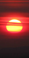
This Image has a Story I believe it was 2005 or 6 when the Marines started running a snowcat dragging a grate West over the route of Highway 108 past the end of the plowed road, creating a "track" over and along the route of the buried highway. I have no idea if they are currently dragging anything out there (except troops) beyond the end of the plowed road during Winter. We still have to get out, moving East, once we reach the end of the plowed portion of Highway 108, back to civilization itself. One of the "cold weather Marines" (being qualified as a "cold weather Marine" is prestigious extra training & skills for "oh-rah" Marines. It is an extra diminsion of being a bad-ass.) will pick us up once we hike past the Marine Base. I've gotten rides from Colonels to E-Zeros out of there during my Wintertime bacpacking trips. And Corpsmen too. And the locals who work out there. I make the distinction between Marines and Corpsmen because Corpsmen are NOT Marines, they are Navy dudes assigned to the grunts. Most Marines like abuse, and most like being "in the field." Most Corpsmen are squids, and they are working extra-hard when they are in the field. They are actually "humanitarians." The Marines will hike over the hardest snow-covered mountains, all to blow your fucking head off. The Corpsmen will go with them, and try to plug up all the holes the Marines received along the way, and maybe even fix-up the folks they did not terminate. That's the distinction. Whoever gives us a ride, be it a Marine officer, grunt, or Corpsman, they will be turning North on Highway 395 if we are lucky. If not we will be standing at the junction of Highways 395 and 108 looking for a ride North on our way towards the bottom of the Carson Valley. At the bottom of Carson Valley we can turn West towards the Tahoe Basin. Unless we are headed South towards Death Valley on Highway 395. Death Valley is amazing during Wintertime. Happy Trails! Area Backpacking Information
Wintertime Backpacking Information
Back to Ouick References
Local Information
|
||||||||||||||
| Sonora Pass Trailheads | ||||||||||||||
| Back to Sonora Pass and Saint Marys Pass Weather Page Sonora Pass Weather Page |
||||||||||||||
7 Day Rain Forecasts & Current Satellite View |
||||||||||||||
Sonora Pass Region Weather
Last page: Ebbetts Pass Region Weather Next page: Emigrant Wilderness Yosemite Weather
| Be Ready for the Range: Basic Facts |
Basic High Sierra Weather Resources for the Backpacker |
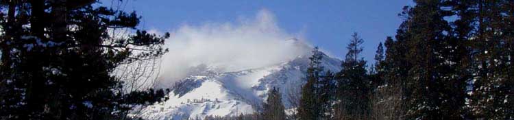
The Sierra Crest is noted for having the capacity to produce four seasons of weather during a single Summer Day. Rain, snow, hail, fog, lightening, and a bit of sunshine can all happen in quick sequence. The High Sierras are noted for rapid changes in weather and temperature, and the sudden appearance of harsh weather trends. You may experience anything from intense heat to bitterly cold Summer snow storms. Or you may not. In any case, weather must be considered and proper gear preparations made to deal with the range of weather BEFORE entering the High Sierras. Long Distance Backpackers who were on the High Sierra Crest in early August of 2009 experienced just such a series of Summer Snow Storms. Temperatures dropped to the high teens and low twenties, snow and hail fell which partially obscured the trails, and all of those who entertained the misconception that the Sierras only have fine weather during the Summertime were bitterly disappointed. Luckily for the many backcountry travelers who were not properly prepared, those storms blew apart, rather than consolidated and deepened. Weather considerations should guide your gear selection. |
Weather Preparations for Backcountry TravelAll SeasonsAll Seasons
|
Backpacker ForumsHave a great Sierra Nevada route or trip to relate?Post it onTahoetoWhitney.Org Anyone can post up comments and questions in existing topics posted on the High Sierra Backpacking Trails Forums or in the High Sierra Backpacking Topics Forums. If you have comments about weather conditions at Sonora Pass and the Highway 108 Corridor, this is the place to post up:Sonora Pass |
North: Highway 4 Weather Sonora Pass Trail Map South: Emigrant Wilderness & Yosemite
Trailhead
Contact
Alex Wierbinski

Backpacking Lake Tahoe to Mount Whitney
Your guide to the High Sierra Crest, including the Tahoe to Yosemite, Pacific Crest, and John Muir Trails
