


30 Minute: Map
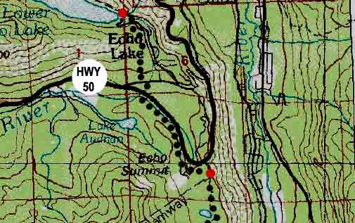
The Echo Lake trail head to the Echo Summit trail head

| Tahoe to Alpine maps index | Trail Guide, Section I | next 30 min MAP page: Echo Summit Trail Head Region | last 30 min map: Lake Aloha to Echo Lake trail head | 7.5 min map: Echo Lake | map info |
Echo Lake trail head to Echo Summit trail head
 |
next MAP page: Echo Summit Trail Head Region (a big version of this map)
previous MAP page: Aloha Lake to Echo Lake
Next Map Guide Segment: Echo Summit Trail Head
Echo Lake trail head to Echo Summit trail head |
Main Features: Echo Summit marks the end of the first segment of your Backpacking Trip: Meeks Bay Trail head to Echo Summit trail head |
Mapping Information |
|
Mileages Echo Lake trail head to the Lake of the Woods Trail on the South side of Aloha Lake: 5.95 miles
Echo Lake Parking Lot to Highway 50: 1 mile Echo Lake Parking Lot to Echo Summit: 2 miles
Echo Lake Trail Head Mileages South Side of Aloha Lake: 5.95 miles Dicks Pass: 13 miles
Meeks Bay to Echo Summit Meeks Bay trail head to Lake Genevieve: 4.71 miles Lake Genevieve to Middle Velma Lake: 6.67 miles Middle Velma to Aloha Lake: 7.69 miles Aloha Lake to Echo Lake trail head: 5.95 miles Meeks Bay trail head to Echo Lake trail head: 25.02 miles Meeks Bay trail head to Echo Summit trail head: 27.02 miles |
Map Name: Placerville Calif, 1976, 30x60 minute Topographic
Compass Offset: Magnetic North is 18 degrees, 34' East of True North
scale: 1:100 000 Contours: 50 meters
Backpacking permitting authority: Lake Tahoe Basin Management Unit National Forest: LTBMU Wilderness Area: Desolation Wilderness Physical location: Meeks Bay Trailhead and Highway 89
Tahoe to Alpine Trail Guide Index Meeks Bay trail head |
| Elevations | More Information | ||
Lake Tahoe: 6226 feet Meeks Bay Trail head: 6239 feet elevation rise: 400 meters, or 1312 feet |
Trail Guide, Section: Meeks Bay to The Carson Gap Trail Guide, Segment: Meeks Bay Trail head Google Map: All Lake Tahoe trailheads |
||
Map Credit: U.S. Geological Survey, Department of the Interior/USGS
(use search term "XXX," and "Address" search type to locate this USGS map)
USGS Topographic Map Information
Comments on this