


Hiking Map
Lake Aloha to Echo Lake Trailhead
Hiking the Tahoe to Yosemite, Tahoe Rim, and Pacific Crest Trails through Desolation Wilderness
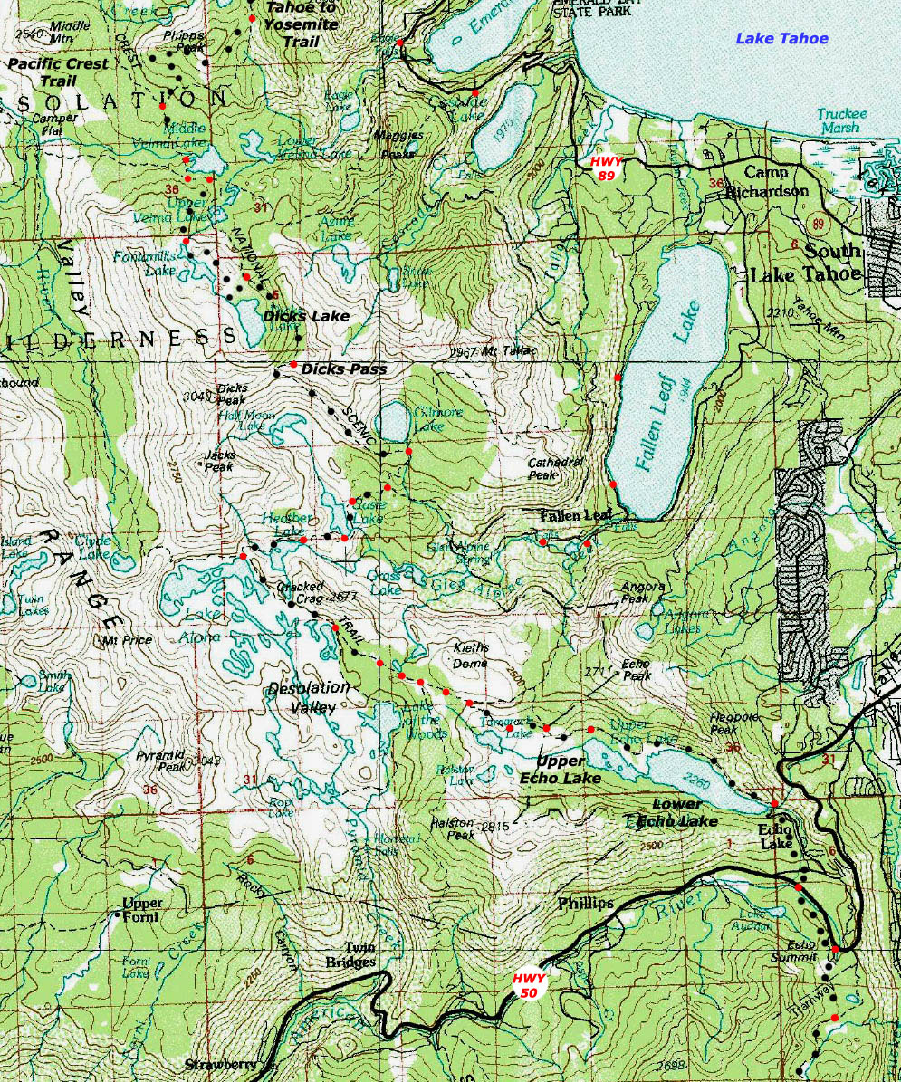
30 minute USGS Topo Backpacking Map of Desolation Wilderness

| Topo Maps INDEX Meeks Bay to Echo Summit |
NORTH 30 min topo Map Meeks Bay to Middle Velma Lake |
SOUTH 7.5 min topo Map Echo Summit to Carson Pass |
SOUTH 30 min topo map Echo Lake trail head to Round Top Lake Meiss Country Roadless Area |
Detailed 7.5 maps NORTH |
Full Desolation Wilderness Topo Hiking Map |
Click Map Dots & Map for links to Trail Guide Pages & Maps |
Trail Guide |
all maps |
all pages | miles and elevations |
map info |
Backpacking Phipps Pass to Echo Summit
into
Meiss Country Roadless Area
LINKED
30 minute Topo Map
Mouse-Over the Map for Links to Detailed Maps and Guide Page Entries
This map has been superceeded-duplicated by the Phipps Pass to Echo Summit 30 minute Hiking Map
30 min map North: North Desolation Wilderness Mileage and Elevations 30 min map South: Echo Summit trailhead to Round Top Lake
|
30 min map North: North Desolation Wilderness 30 min map South : Echo Summit trailhead to Round Top Lake
Middle Velma is Where the Tahoe to Yosemite Trail out of Meeks Bay joins the Southbound Pacific Crest Trail.
Dicks Pass through Echo Lake Trailhead |
||||
Main Features After passing South of Lake Aloha we again reenter forest cover, which brings much softer trail and more shade than the exposed hard rock surfaces around Lake Aloha. The feet are happy with the reduction in impact stress rolling down the mountain. As we continue South beautiful views of the Echo Lakes stretch out in front of us. During the Summer we have the option of taking a boat taxi ride from the North end of Upper Echo Lake, if you are too lazy to enjoy the hike around Echo Lakes to the Echo Lake Trailhead. MAP NOTE What's important for our general reference purpose is that each side of a square is 1000 meters, or a Kilometer. From my point of view that is 1093 yards or .62 of a mile. Diagonal: 1414.22 meters, if my trig is correct. That converts into 4,639.8 feet or .88 of a mile.
|
Desolation Wilderness Mileage and Mapping Information |
|
MileagesN side of Aloha Lake to Echo Lake trail head: 7.55 miles
Echo Lake Trailhead Sign MileagesDicks Pass: 13 My count: 10.55
Meeks Bay to Echo Summit Meeks Bay trail head to Lake Genevieve Lake Genevieve to Middle Velma Lake Middle Velma to N. side, Aloha Lake Aloha Lake to Echo Lake trail head
Totals Meeks Bay trail head to Echo Lake trail head 28.71 miles Meeks Bay trail head to Echo Summit trail head 30.71 miles
Tahoe to Alpine Trail Guide Meeks Bay |
USGS
|
last 30 min map: Middle Velma Lake to Aloha Lake next 30 min map: Echo Lake trail head to Echo Summit trail head
| Elevations | More Information | ||
Lake Aloha Echo Lake elevation change |
Trail Guide, Section Trail Guide, Segment Google Map |
||
Map Credit |
U.S. Geological Survey, Department of the Interior The USGS Get this topo from the:
USGS Topographic Map Information |
This trail started at the
Meeks Bay Trailhead