Tree, Poison Flat, Carson Iceberg Lake Tahoe to Mount Whitney: Your Backpacking Guide to the High Sierras Yellow Flower
Fine trail work: boulder stair case, Echo Summit to Carson Pass.
Finely crafted granite boulder staircase South of Echo Summit. Note the recent hoof scraping.


The Trails

Guide
Maps
Miles/Ele
Permits
Resupply
Forum

Current Weather Conditions

Weather Notes
Northern High Sierras
Central High Sierras
Southern High Sierras


Gear

Gear List
Gettin Started
Layering
Discussion


Testing yourself and your gear


Gear Reviews


top of page

Backpacking
Meiss Country Roadless Area

Hiking The Tahoe Rim from Echo Summit to Showers Lake


Languages

Languages


Trail Arts

The art of walking
 
Physical Preperation


Trail Skills

The trail
Off the trail
Scrambling
Maps
Navigation
Camp skills
 

Food

Resupply
Food


Other

Photo Catagories
Trail Stories
Trail Culture
News and Science
Links
Groups
Books


Terms and Conditions of Use


top of page

Trail
Guide


INDEX
North

Footbridge
to
Echo
Summit
South

View,
Rest Spot, Great Company
Topo Map

Echo 
Summit
to
Carson
Pass

Maps
INDEX
MILES
and
ELEVATIONS

Miles
and
Elevations
INDEX
Lake Tahoe
Basin
PERMITS
Local
Weather


All Sierra Weather
All
Wilderness PERMITS
Tahoe
to
Whitney
on
YouTube

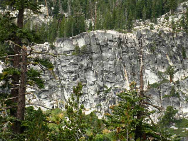
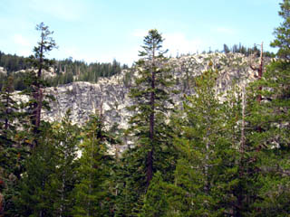
Massive Granite Wall

Massive Rock Wall, Detail

What
Hiking the unified routes of the Tahoe to Yosemite Trail, Pacific Crest Trail, and Tahoe Rim Trail South through the Echo Summit Trailhead into the Meiss Country Roadless Area.

Hiking South
After crossing the footbridge 1.41 miles South of Echo Summit we begin climbing, winding our way up, around, and through massive granite formations shrouded in deep forest that make up the East flank of the sheer granite gorge we are entering.

This is not the "wide-open" granite terrain of the Desolation Wilderness. Not at all.

We are climbing 1120 feet of elevation over the next 1.48 miles from the bridge to the highpoint (8760 feet) of this bit of trail up the gorge under Peak 8905. This next segment rates as an Intermediate-1 trail with bits of H-3 difficulty thrown in for good measure.

Character of the Terrain
The trail climbing South of Echo Summit past the footbridge is very "closed-in," with most hopes of long views subdued by the jagged sheer terrain and dense forests in and around the gorge.
We note we are hiking Southwest up along the East flank of a narrow cut in the terrain bringing us higher and deeper into the steepening gorge along the "inside" route, opposite the sheer cliffs dropping into Christmas Valley on the East flank of this same arm of the ridge.

Thus our position climbing through this gorge/ravine is only going to give us little slices of fragmentary views we can get glimpses of to our Northeast, at Lake Tahoe, through narrow breaks in the forest and rock cover as the terrain briefly opens-up and quickly closes-in around us as we climb.
We find an exception where our trail turns East out of the gorge through a gap in the top of the ridge arm to a very comfortable and well-used overview/break spot about halfway up along our climb.
I've noted on the map where I believe the top of this segment of the trail has been re-routed around the outside of the ridgetop.
Nonetheless, we'll stop and take it all in from there, and use the perspective these clear views of our surrounding terrain our break spot gives us to better situate ourselves in context with the landmarks decorating the South end of the Tahoe Basin.

Ahhhh!
This close-in terrain South of Echo Summit has a unique feel and appeal all its own. There is a quiet, muffled beauty of close rock and forest here, accented by a palatable pressure generated by close-in spaces. We get a very different "feel" here when compared against the almost vacuum-like feel we experienced hiking across the wide-open grandeur of the expansive exposed granite terrain across much of Desolation Wilderness.

Run yourself through these divergent "open" and "closed" environments, through Desolation Wilderness and Meiss Country in quick succession, to better take note of the very different "feel" each environment induces.
My take on these shifting "feelings" generated by shifting environments is that every environment induces humans to take up the best perspective and practices necessary to deal with the practical requirements of that particular environment.

We experience this automatic internal environmental adjustment as a change in how our perception actually "feels." The mechanisms of this adjustments are spread across and even below the range of our human perceptions.
Important environmental information is gleaned from our fundamental abilities to sense pressure, humidity, scent, and temperature changes. More subtle and sophisticated are the psychological shifts in awareness and attitude accompanying changes in the environment. Here in this close-in gorge our perception is registering the great shift in environments from Desolation to Meiss Country, which is stimulating our senses.

Things have changed. We are watchful, almost nervous trading in the security of long views for the security of close-in cover. Things have changed.

We can feel reality consolidate and close in around us as we shift from the wide open spaces of Desolation Wilderness into the narrowing confines of the bottom end of the Tahoe Basin.

To our West-Northwest across the gorge we can see a series of granite ridge-arms descending off the rim of the Tahoe Basin above and beyond the limits of our gorge, which here is also part of the East flank of the Sierra Crestline. This presents us with views of walls of majestic granite emerging out of their dense forest coverage as granite waves rising out of a rough green ocean of trees, as seen in the image above. Surf's Up!

Studying the map shows how we are hiking South and Southwest following the cuts in the granite terrain up this tight little gorge with its set of cascading nested flats under Peak 8905. About halfway up we can see where we turn East out of the gorge following the view through the ridgetop gap into a magnificent overview-break spot.

Bottom of the Basin
Our trail is in fact heading away from Lake Tahoe, pointing South and Southwest to follow the convoluted curve of the Sierra Crest wrapping around the the Southwestern-most bottom end of the Tahoe Basin.
Hiking our first climb over the bottom of the low ridge arm separating Echo Summit from Frog Lake brought us into the watershed of the South Upper Truckee draining the South end of the Tahoe Basin.

Hiking over the Shoulder of Peak 8905 brings us back onto the Western Flank for a short distance, until we begin straddling the Crest of the Tahoe Rim South to the point we turn decisively back into the Tahoe Watershed a short distance South of the Schneiders Camp trail junction.

At that point we are entering the very Southernmost end of the Tahoe Basin where we begin curving with the bottom of the U-shape Christmas Valley, which consists of the Sierra and Carson Ranges running parallel to each other before intersecting at the bottom of the "U" at Carson Gap.
Looking East from the few vantage points we have South of Echo Summit climbing to Peak 8905 we find we are gazing across Christmas Valley at the volcanic features decorating the very Southern end of the Carson Range.

South Upper Truckee River
Meiss Meadow is the Southernmost confluence point of the watershed draining the mountains wrapping around "bottom of the U," which is the South end of the Tahoe Basin.
Meiss Meadow is a shelf below the mountaintops that collects all the runoff from these converging mountain ranges wrapping around the South end of the Tahoe Basin.

The headwaters branch of the South Upper Truckee feeding Meiss Meadow bisects the meadow where it flows out of the ravine it cut in the Southernmost end of the Tahoe Basin from its Source in the Carson Gap.

That upper slash of the South Upper Truckee reaching up to the top of the Tahoe Rim in the bottom end of the Tahoe Basin is the natural feature our combined TYT-PCT follows out the South end of the Tahoe Basin.

Meiss Meadow is the collection point for the massive runoff from the half-circle of Tahoe Rim Mountains rising above the meadow and wrapping around the South end of the Tahoe Basin on either side of the Carson Gap. Meiss Meadow is quite a pretty scene during Winter, Spring, Summer, and Fall.

The mountains running Northeast from Carson Gap making up the mountains wrapping around the East Shore of Lake Tahoe are in the Carson Range. The mountains running Northwest from Carson Gap are part of the Sierra Range.
Further down-river and down-mountain below Meiss Meadow a complex network of creeks and tributaries draining length, width, and heights of the narrow U-shaped Christmas Valley all flow down into the South Upper Truckee, through the township of Meyers, and into Lake Tahoe just beyond.

From our current position just a couple of miles South of the Echo Summit Trailhead we can see granite-walled ridge arms rising to our West up to the Sierra Crestline above us, capping this segment of the Western Wall of the Tahoe Basin running down to the Carson Gap.

Turning East gives us a view, from the places that is possible, across Christmas Valley of the earthy burnt red volcanic terrain and features that characterize the majority of the Carson Range. We have taken note of the more volcanic, barren, and sage covered terrain making up the Eastern Range wrapping around Lake Tahoe Basin we have observed since we started hiking South across Desolation Wilderness.
(Views East & Southeast open up on the next page).

Out of the Tahoe Basin
Our still unified Southbound TYT and PCT routes exit the Tahoe Basin through the Carson Gap that I identify as being the point where the Carson and Sierra Mountain Ranges converge at the Southernmost end of the Lake Tahoe Basin.

From the Carson Gap the Southbound PCT points itself Southeast towards Carson Pass where hikers on the Tahoe to Yosemite Trail encounter the first of three potential trails pointing them Southwest along the Tahoe to Yosemite Trail.
We'll either select one of three potential routes to get from the Carson Gap to the top of Round Top and the Sisters, or we will continue South on the PCT through Carson Pass.

Below our current position here, a bit South of Echo Summit, sits Christmas Valley, or Lake Valley as it was known in earlier days. The South Upper Truckee runs South to North through Christmas Valley bringing its collected runoff out of the Southernmost end of the Tahoe Basin to the Lake.

Expansive Overlooks and Obstructed Views
This terrain offers many excellent short-views of nearby sheer rock and dense forest, and every now and then a long view Northeast of Lake Tahoe or a brief glimpse East into and across Christmas Valley at the bottom of the Carson Range through trees and terrain.

Fantastic granite walls rise towards the top of the Tahoe Rim drainage to our West. Fantastic terrain. But, this is a very different kind of fantastic than we experienced in Desolation Wilderness.
It is interesting that we are already experiencing a very wide range of wilderness experiences, of terrains and topography across a small number of miles, and we are just getting started exploring the North Sierra!

Cool Break Spot Coming Up
There's a spot further down the trail, a little over halfway up the climb bringing us over Peak 8905, where we can actually see Round Top sitting to our South outside of the Tahoe Basin, and get a good look up, down, and across Christmas Valley giving us some good looks at the topographical features of South end of the Tahoe Basin.

On the majority of the trail between the Frog Pond trail junction and the top of Peak 8905 above the Sayles Canyon trail junction, we are deep within a complex forest and rock terrain. And we are climbing.

Very Nice.

Hiking Map South
Meiss Country Roadless Area
Echo Summit to Carson Pass
Backpacking Miles and Elevations

Comments-questions-experiences in here?

top of page


The whole massive rock wall   Trail through Meiss South of Echo Summit
The rock wall to the West, and the line of the Sierra Crest beyond, in the distance. Typical soft forest trail bed through lots of broken rock.

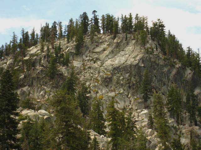
Great Blocks of Granite Rock

Rock and Tree

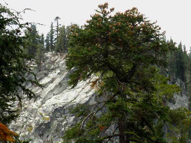
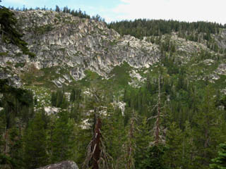
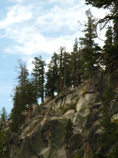
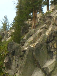
Cutting through a channel up to our Left between massive, yet compact granite ridge tops. By "compact," I mean these walls are in close proximity to each other, with the ratio of height to width being very high.

That means that the faces are steep and deep, the tops of the faces short and narrow, and another set of steep and deep ridge/gorge combinations is close by. My definition of "compact," is a whole lot of terrain and terrain detail in a very small space.

This gorge and the area encompassing it, stretching from the line of the Sierra Crest above it down to the South Upper Truckee River beyond the base of Christmas Valley's cliffs, is one heck of a complex piece of terrain.

Meiss Country Roadless Area
backpacking map


Stairway to Heaven?

Starting up fine staircase trail feature   Continuing on this massive beauitiful staircase trail work
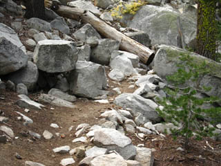
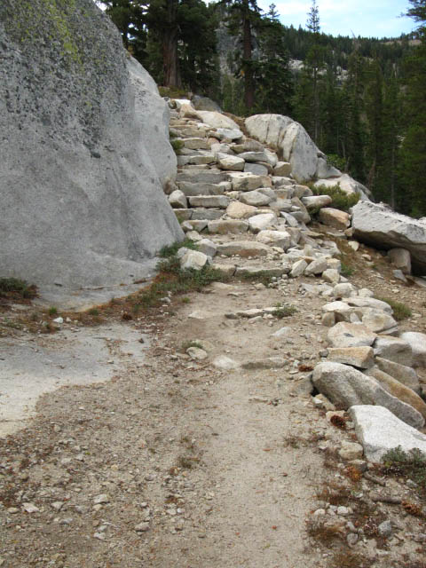
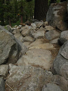
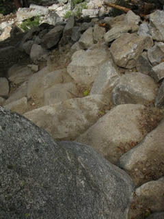
  Great Trail work up the East flank of our rocky gorge: stairway.      A very long stairway, it turned out.

North: Footbridge to Echo Summit                                           South: View, Rest Spot, Great Company

Granite Wall
South
of
Echo Summit
Backpacking
The Meiss Country Roadless Area

I'm referring to the great granite wall pictured at the top of this page.

Our Position.

Elevation
8000 ft

+623 feet above Echo Summit

Mileage

1.78 miles South from Echo Summit.

5.02 miles South to Showers Lake.

10.22 miles South to Carson Pass.

Backpacking Map
Meiss Country Roadless Area

Meiss Country
Miles and Elevations

Granite and Forest

Afternoon Clouds crowning Lake Tahoe Rock formations set the tone of the Southern drainage of Lake Tahoe
Though there are few views of Lake Tahoe along this segment of our trail, the momentary glimpses of the Lake we get are welcome. Here, over the trees for a second! There it is! The Tahoe Rim and Sierra Crestline, us looking Northwest at where the slope is dropping down towards Echo Summit.
Down again, but on a fine staircase Another view of this fine stair

This stairway is a real piece of excellent trail work.

Note how the boulders are perfectly fit and interlocked together directing the weight and loading forces of the staircase to impart stability into the rock fall it crosses.

This is expert rock work done by a very experienced rock team with a good perspective on complex situations.

Nice.

In the picture above left we see how the staircase of boulders first appears to be part of the rock jumble.

Once we differentiate the top of the stairs, the body of the staircase seem to melt into the rock jumble below.

But the staircase does not melt away.

This is an optical illusion, an effect of the natural camouflage provided by its unobtrusive design.

As we continue down we find a finely fit staircase appears at each step of the trail down this rock-choked descent.

This is an expert piece of trail work.

And a very nice staircase it is!

top of page


Detail of the rock staircase

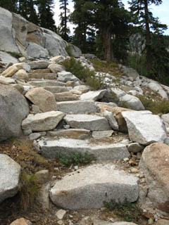
Perfectly fit granite rock steps.

We are going to observe, take note of, and enjoy the fine trail work we cross on our way down to the Whitney Portal. We will be enjoying and appreciating the fruits of many generations of Trail Crew Workers.

Trail Culture>Trail Crew Forum

ALERT
Watch Out for Sand on Smooth Rock surfaces! Sand is Very Slippery and Dangerous on smooth granite! Flatten and shorten your steps. Do not let your feet shoot out from under you!

The Art of Walking

Stay square
and
Stay Aware.

You wind your way around numerous local crests of the High Sierrs
Above: Detail of peak NW of Peak 8905
Local crests Rock Details

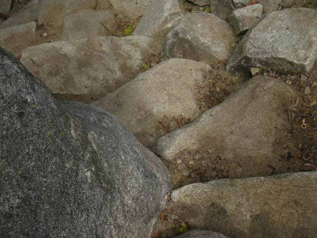
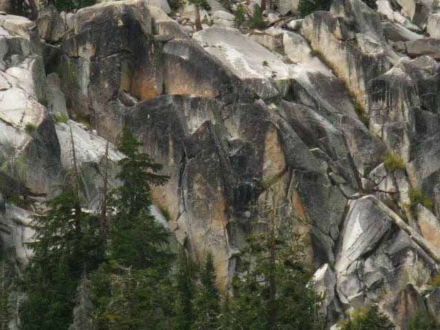
Above: Mineral staining paints the granite rock formations. Note the dense, un jointed nature of this battleship gray and rust-red streaked granite.

We are going to take note of the details, of the density, jointing, and staining characterizing the various granites we encounter. We will note how the external sculpting of ice and erosion changes from area to area as we note changes in the characters of the granites.

.
  West flank of the Granite gap we are passing to a fine vista and break spot.

Detail. The 30 minute map gives up a better context about the terrain to the West of our trail, showing the full extent of the trails down to

Echo Summit to Round Top and the Sisters

North: Footbridge to Echo Summit                                           South: View, Rest Spot, Great Company

The Roller Coaster Trail
up and around
The Tahoe Rim South
of Echo Summit

South of the Footbridge

Crossing the footbridge South of Echo Summit on the Southwest edge of Benwood Meadow hiking South towards Showers Lake marks our entrance onto a steadily climbing roller coaster who's ticket to ride is our backpacking permit.

Oh, wait, we don't even need a permit for overnight backpacking in the Meiss Country Roadless Area, though we do need a fire permit, even for our stove.

So we do need a permit, though not a backpacking permit. For backpacking bums like me who rely on public transportation and hitch hiking, it is a real hassle to get to the damn Ranger Station on the way to the trail head, to pick up pack or fire permits.

I prefer to have "permit in hand" when I walk out my front door the day the trip begins.

For trips into Meiss Country in the Tahoe Basin we have to contact the Lake Tahoe Basin Management Unit for specific information about obtaining our fire permits.

Last times I hiked through Echo Summit and the South Upper Truckee Trailheads into the Meiss Country Roadless Area there were self-registered fire permit books at the trailheads.

That's good for covering short trips staying within Meiss Country, as the Ranger Stations are generally nowhere near the main trail heads I employ. Having fire permits at the trailhead saves me a lot of hard travel time.

But it does not solve the problems I have as a long distance backpacker obtaining permits for long trips beginning out of Meiss Country Roadless Area Trailheads.

These problems are not any agency or anybody's fault, but are just in the nature of my transportation situation.

Although we do not need a backpacking permit for trips remaining within Meiss Country, we will need a permit from the LTBMU to authorize travel over all the National Forests and wilderness areas our trip crosses after departing Meiss Country and/or the Tahoe Basin.

The federal rules of backpacking permits stipulate that all federal agencies issuing backpacking permits and administering public lands must honor the backpacking permits issued by the agency administering the backpacker's starting trailhead, if the route between the two is continuous.

I am pretty sure permit reciprocity operates between the federal and state agencies, between their forests and parks agencies, but I've never had the need to know.

All the trips on this guide hike from National Forest to Forest, from Wilderness Area to Area, and from Forest to Park.
Our initial permit issued by the authority supervising the starting trailhead of our trip(usually a Ranger District), is good for all the points down the trails specified on the permit linking our starting and ending trailheads.

The Takeaway: We get our permit for our whole trip from the agency supervising our starting trailhead.

Thus I am thankful that I can usually talk the cool folks at the Lake Tahoe Basin Management Unit into sending me the fire permit and/or necessary long distance permits through the mails before I depart.

This courtesy saves me hours of getting to the Ranger's Office, then out to the trailhead, as I deploy insufficient public transportation, my thumb, and occasionally my feet to get from my front door to the starting trailhead.

I am not a big fan of "backpacking" to the starting trailhead, but I've become accustomed to beginning the backpacking trip when I walk out my front door.

I much prefer to have known start and end points. Sometimes we have to accept that ambiguity is unavoidable.

Good people, those Rangers and NPS employees. And I've always had a deep appreciation for trail workers.

Just look at that staircase above!

National Park Service
and
National Forest Employees

My appreciation for the NPS and NF employees starts from the ground up: The closer to the ground they are, the better I like them.

Thus trail workers are at the top of the heap, followed by the science crews who track, watch, and count the various critters. After that we've got the horse-packers who supply the kids working in the backcountry. Then we must recognize the role that the Resupply Point staffs play in the life of a long distance backpacker. Though not public employees, these people are vital.

After that we've got the office staffs who issue us permits. Finally, we have Rangers. I remember when Rangers were wildlife experts who spent extensive time in the backcountry. I still meet the Naturalist/Backcountry Rangers on the trail, but I categorize them as scientists, not Rangers.

Most Rangers are now more cop than real Rangers, and drive cop cars around the big parks. They write speeding tickets and bust drunk car campers. Yeah, that's a "Ranger." Sure.

But, all the Yahoos we pack into the major parks every Summer have altered the role and character of Rangers over the years.

It's nature:
You change one key thing, and a chain of consequences changes the rest.

In our case gross overpopulation and irresponsible growth have unleashed a chain of social, political and environmental repercussions.

Hold on tight. This is going to be a wild ride...

In any case, Thanks to all of you people who work in the mountains, for all of your fine work and help keeping the mountain trails open.

Trail Culture Forum
Trail Crew Forum High Sierra Backpacker Resupply Forum

top of page

Back to the Trail South from Echo Summit...

This fine section of Intermediate 1 Difficulty (Trail Difficulty Rating System) trail past the footbridge travels through deep forest while winding around, through, and steadily upward between precipitous rock walls, ridge tops, mini-peaks, and deep drainages. The trail is very well laid out and takes the easiest and most stable route possible through this difficult terrain.

The difficulty level of this trail is the hardest degree of intermediate difficulty, crossing into the lowest level of high difficulty for brief periods.

Why? Our elevation is not too high, and the rising washboard section of the trail is short.

See the
Trail Rating System

From the foot bridge we have worked ourselves up, around, and through the closed-in terrain of rock, forest, and ravine towards a position where we begin to gain stunning views East and South.

Shortly we will come to a gap in the mountains overlooking Christmas Valley that is a natural break and gathering spot for hikers through this route.

It's a natural meeting place for us backpacking folk.

7.5 min hiking Topo Map
Echo Summit to Carson Pass
30 min hiking Topo Map
Echo Summit to Round Top and the Sisters

Miles and Elevations

Video Playlist
Echo Summit to Carson Gap

Next page
South

View, Rest Spot, Great Company

top of page

Backpacking Trail Guide

North

Footbridge
to
Echo Summit

Trail Guide internal Compass.

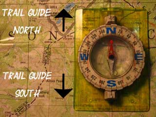
Backpacking Trail Guide

South

View, Rest Spot,
Great Company

Backpacker Forums

Have a backpacking TRIP to relate?
Have a backpacking ISSUE to relate?

Post 'em both on
TahoetoWhitney.Org
The Backpacker's Forums.

Our High Sierra Backpacker's Forum naturally breaks itself down into two main categories, being Trails and Topics.
High Sierra Trails High Sierra Topics
Though the Trails Forums are mostly confined to the Sierra Nevada, the Backpacking Topics Forums deal with issues all backpackers encounter which are universally important to all backpackers.

On the Trails Forum we can browse trail locations and add our experiences, comments, questions, or pictures and videos specifically about hiking South out of the Echo Summit Trail Head.

I am especially interested in the context of your use of Echo Summit Trailhead. Were you hiking a short trip into Meiss Country, a longer "section hike" down the Sierra Crest, the full TYT package to Tuolumne Meadows, or the whole Tahoe to Whitney Adventure?

I really believe that one important aspect of life and reality is the sum total of all our experiences. I want to gather as many High Sierra backpacker experiences here as possible.

Section
Echo Summit to Carson Pass
Segment
Mountain Roller Coaster South of Echo Summit

North: Footbridge to Echo Summit                                           South: View, Rest Spot, Great Company

Trailhead
Contact
Alex Wierbinski

top of page

Frosted Backpack

Backpacking Lake Tahoe to Mount Whitney

Your guide to the High Sierra Crest, including the Tahoe to Yosemite, Pacific Crest, and John Muir Trails

Snug tent after Snow Storm
© Lake Tahoe to Mount Whitney: Crown Jewel of the Pacific Crest Trail