High Sierra
Backpacking
Trail Guide
Forums
Sierra
Weather
WeatherNotes Northern
Sierra Weather
Gear
The Tahoe to Yosemite Trail
Hiking from Rubicon Lake to Phipps Pass
Backpacking out of the Meeks Bay Trailhead on The Tahoe to Yosemite Trail
Languages
Trail Skills
Mountain
Safety
Food
Planning
Trail Arts
More
Information
Social
| Trail Guide Section INDEX |
North |
South TYT Phipps Pass |
Trail Miles & Elevations |
Trail Miles & Elevations INDEX |
Lake Tahoe Basin Management Unit PERMITS |
All forest-wilderness Permits |
Hiking South
Up to Phipps Pass
along the
Tahoe to Yosemite Trail
A Highlight Segment
|
| North Desolation Wilderness Backpacking Map |
Central Desolation Wilderness Backpacking Map |
All Desolation Wilderness
Backpacking Map
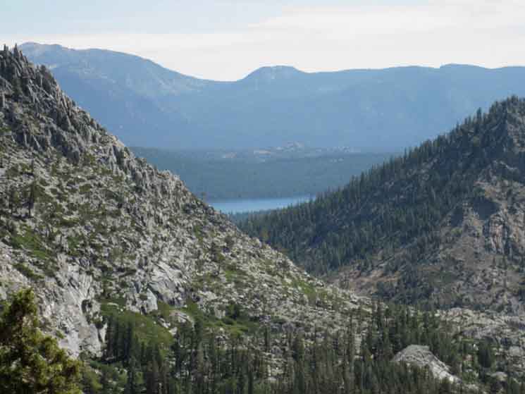
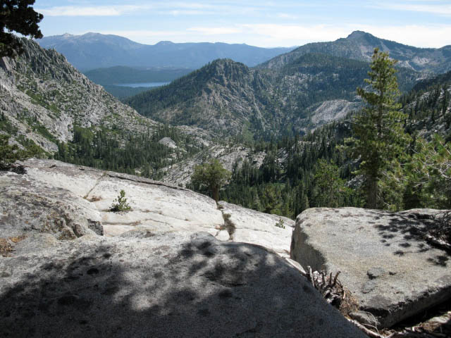
The View Southeast from Phipps Pass
Looking further afield to our Southeast beyond Grouse Lakes and the impressive ridge arms surrounding them at our feet, we can see the distant terrain forming up into an epic broad panorama composed of the main elements of the Southeastern Corner of Lake Tahoe and the Tahoe Basin. Well, the terrain that we can see between and around the massive ridgelines descending off Maggies and Tallac Peaks, dropping North down to the Western shore of Lake Tahoe.
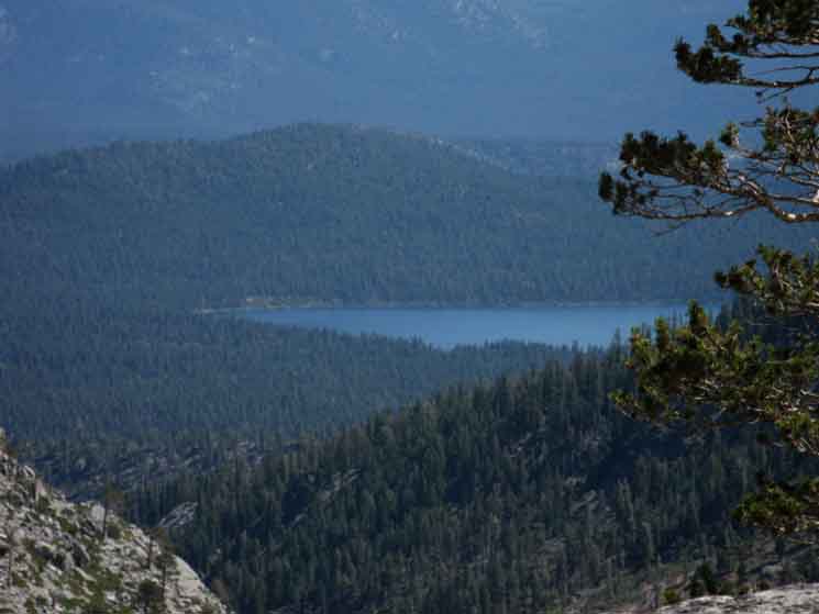
Tallac and Maggies Peaks are the commanding features decorating our view of the near and middle distant terrain from Phipps Pass. Maggies Peaks rise to become the far Southeastern side of the basin holding the Velma Lakes below, between us an Maggies Peaks.
Maggies Peaks are about a mile distant across the basin, Mount Tallac rising in the Southeast maybe two and a half miles from Phipps Pass, beyond the both the basin and Maggies Peaks. We can even make out the outline of Freel Peak far to our East dominating the Southeastern corner of the Carson Range beyond the Southeast corner of Lake Tahoe. Closer to us we can see the North end of Cascade Lake sticking out beyond the North end of Maggies Peaks ridgeline where it steeply terminates descending to Eagle Falls.
We have quite an expansive view from Phipps Pass.
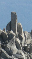
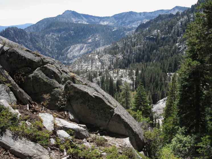
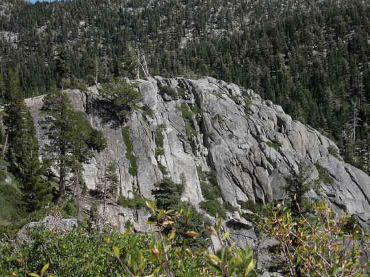
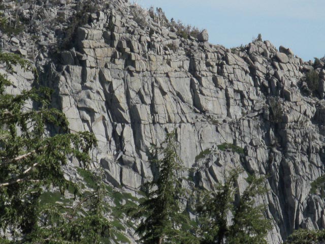
Closer to us, below and even rising above us to the East-Northeast of our position approaching Phipps Pass is the remarkable, stunningly-beautifully impressive thousand foot+ sheer Southwest-facing flank of shattered granite cliffs making up the face of the ridge wrapping around the North and East Shores of Grouse Lakes, capped by peak 9195. A picture of its Southwest-facing flank decorates the banner of this guide page, above.
Is that a stunning chunk of shattered rock, or what!
WATERSHEDS
About halfway across this long traverse South under Phipps Peak we finally cross the line of the watershed, Phipps Pass, dividing the Northeast and Southeastern flanks of the Phipps Peak draining into Lake Tahoe from the Southwestern Flank's draining West into the Rubicon River, and ultimately the Middle Fork of the American River. Our gradual final ascent up to Phipps Pass shifts to a long gradual descent once we cross the pass and start hiking down the Southwestern Flank of Phipps Peak.
Our hike down from Phipps Pass to the PCT trail junction, then further down the TYT to the low point of this segment of trail at Middle Velma Lake, is much less steep than our hike up to Phipps Pass from Stoney Ridge Lake.
Meeks Bay to Echo Summit
Backpacking Miles and Elevations
Weather Information
Local Temp and Snow Reporting Stations
Click the Big Red Dots.
| Tahoe Basin Weather | All High Sierra Weather |
Lake Tahoe Basin 7-Day Weather Forecast
WHY DESOLATION
This is way-cool terrain across Phipps Pass. All across Desolation Wilderness, in fact. The accessibility of this striking beauty is why Desolation is so popular. Stunning beauty is so very close to a road, and so many people are located nearby in the Tahoe Basin, in Reno and Carson Valley, and coming from Sacramento and the Bay Area.
It is 8.88 miles to Phipps Pass from Meeks Bay. And, access gets better as we hike deeper into Desolation Wilderness. The route North to Phipps Pass from Eagle Falls Trailhead is 7.7 miles, putting the distance from Meeks Bay Trailhead to Eagle Falls Trailhead at 16.58 miles of fun. That trip puts us both at the bottom of the gorge below Phipps Pass and onto Phipps Pass.
My point is that our route on the TYT-PCT-TRT across the length of Desolation is paralleled by a series of Trailheads on Highway 89 along the West Shore of Lake Tahoe.
All Desolation Wilderness Backpacking Trails Map
The character of Desolation's striking beauty goes through a range of different expressions and juxtapositions that we can easily access for shorter Trailhead to Trailhead Trips and longer Backpacking Loops using this range of trailheads stationed parallel to the the route of the TYT-PCT-TRT across the length of Desolation Wilderness.
This federal document is informative about Desolation Backpacking:
National Forest Complete Guide, PDF
Planning Backpacking Trips in Desolation Wilderness
Also see
Desolation Wilderness and related permitting information resources.
Local Beauty
Local Backpacking Trip Options
Our views of these massive ridge arms descending off Phipps Peak to the Southeast are quite remarkable, and well worth the pain of walking a heck of a lot further and longer than the 8.88 miles we hiked to get up here from Meeks Bay.
We mentioned above the shorter, but much steeper trail hiking West from Eagle Falls Trailhead on Highway 89 to the TYT at Middle Velma Lake. This route brings hikers West passing under the base of the amazing granite gorge below the Southeastern facing flank of Phipps Peak.
The trail West from Eagle Falls passes through a narrow gap in the mountains between the base of these cliffs off the Southeast flank of Phipps Peak and the steeply terminating Northern ridgeline of Maggies Peaks. The trail climbing steeply West from Eagle Falls is on its way West to intersect with our route TYT-PCT through a series of trail junction to our North.
The route West from Eagle Falls splits through all three of the series of 3 Bayview-Camper Flat trail junctions we will encounter hiking South of Middle Velma Lake. We Southbound backpackers on the TYT hit the first, the Northernmost of these 3 trail junctions just steps South of Middle Velma Lake.
Northeast Desolation Wilderness Trailhead to Trailhead Backpacking Trip
We will check out more of the route of this 16.58 mile potential Meeks Bay to Eagle Falls trailhead to trailhead trips as we hike South approaching the second Bayview-Camper Flat trail junction. The second Bayview-Camper Flat junction is where we would continue hiking East towards Eagle Falls and Lake Tahoe, rather than turning Right to stay on the Southbound Tahoe to Yosemite Trail.
Central Desolation Wilderness
Backpacking Map
TERRAIN NOTE
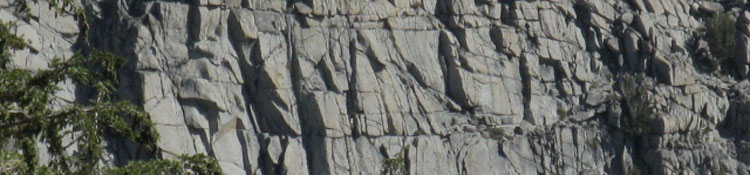
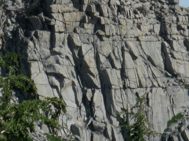
The Southern ridge arm bracketing this precipitous Grouse Lake canyon (really a deep gorge running down the sheer Northeast flank under Phipps Peak in a couple of brutally steep steps), also sports a sheer face, but the North-facing cliffs on the Southern ridge arm are different.
The granite of the South Ridge is composed of big expanses of a much harder, and an almost unjointed granite. The ridge arm making up Southern wall of the canyon rising above Grouse Lakes descends off the main bulk of Phipps Peak to the Southwest of, and parallel to the massive shattered granite wall rising above the North shore of Grouse Lakes.
This Southern ridge arm descends to the Southeast from the exact position of Phipps Pass.
The unjointed granite of the South ridge arm is very different from the shattered granite making up the North face of the ridge above Grouse Lakes!
Shattered granite on the North side of the gorge, smooth on the South.
INFINITIES
INSIDE and OUT
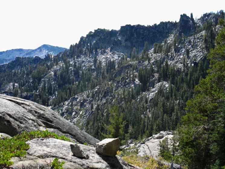
Studying the terrain around us at Phipps Pass reveals a complex scene. "Minor" ridge arms and other fantastic granite features of all forms and shapes decorate and diverge from the main features. All are made up of massive sheer jumbles of shattered rock as well as massive mounds and mini-walls of hard unjointed granite. All descend to our Southeast off of the main crest lines of both ridges at our feet. The sides of these ridges compose the steep canyon walls bracketing Grouse Lakes. Beyond are the major peaks, passes, and ridges of South Desolation Wilderness and the South End of the Tahoe Basin beyond.
To our South and Southeast from Phipps Pass we can see how Maggies and Tallac Peaks highlight the series of mountains wrapping around the Northeastern perimeter of the beautiful basin holding the Velma Lakes. Looking Northwest we can see Dicks Peak capping the ridgeline running North and South dividing the Velma Lakes Basin on its Eastern side, Left from our perspective standing in Phipps Pass, from Rockbound Valleys running North and South below its Western flank.
Whole Emigrant Wilderness Topo Map.
Click Map for Detailed Maps
Jigsaw Puzzle of the Rock Gods
The nearby terrain details on these huge ridge arms are impossibly complex three-dimensional physical jigsaw puzzles made up of every size and shape of whole and shattered granite rocks, blocks, and faces.
Looking a bit further, It looks like there are 2400 feet of amazingly complex cliff/mountain terrain dropping from the top of Peak 9195 (atop the ridgearm/cliffs that rises above the North Shore of Grouse Lakes, the cliff face to our Left standing in Phipps Pass) down to where its base provides the gap the Eagle Falls trail passes West through to enter the meadow below Eagle Lake.
Check the Meeks Bay to Dicks Pass map for details.
In the distance below us to our South and Southwest we can see bits of The Velma Lakes in the basin below, Maggies Peaks rising to their Southeast around the lakes, and Tallac in the further distance to our Southeast.
The complexity of the terrain we can see from Phipps Pass is amazing. This is a great place to sit with a good map and line-up the terrain features with each other and us.
And, our view gets better and more interesting the more time we spend, and the closer we inspect it. We find an infinity of details within nearby terrain, within the narrowness of a close inspection. We find infinity afar, across the vast scope of this grand, breathtaking terrain around us. We find infinity in distance and in detail.
This is going to take a few trips to attain reasonable familiarity.
The Range of Granite in the Range of Light
The range of granite formations we see hiking the short distance from Stony Ridge to Rubicon Lakes to Phipps Pass is frkn amazing. From huge slabs of almost seamless unjointed granite, to huge fractured slabs jointed like a huge shattered rock chessboard. This stack of shattered rock appears to be getting into the middle of a thousand year process of falling apart right before our eyes, if we look real close.
This shattered granite ridge is breaking up in slow motion by our reckoning, but it's plain to see that parts of this massive shattered Northern ridge are breaking up at a break-neck geological pace, while the vast sections of unjointed granite on the Southern ridge are barely wearing at all.
See 'em while you can!
Some of these features will be gone before our lives end, others may well outlast mankind.
| Meeks Bay to Dicks Pass 15 minute Backpacking Map |
Desolation Wilderness 30 minute Backpacking Map |
Desolation Wilderness
Meeks Bay
|
| Northernmost Desolation Wilderness 7.5 MAP |
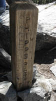
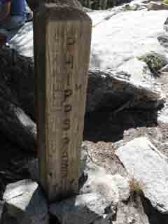
Phipps Pass
Elevation
8800 feet
2561 foot elevation gain above Meeks Bay trail head hiking 8.88 miles South.
Miles North
1.13 miles and 480 feet of elevation North down to Rubicon Lake at
8320 feet of elevation.
Miles South
Phipps Pass is 2.62 miles North, and 720 feet above our upcoming trail junction where the Tahoe to Yosemite Trail route joins with both the Pacific Crest and Tahoe Rim Trails a bit North of Middle Velma Lake.
Middle Velma Lake is 3.44 miles South of Phipps Pass.
Middle Velma Lake is 880 feet below Phipps Pass.
More
Miles South
Check out the Eagle Falls-Bayview-Velma Lakes Map Schematic
I have the distance from Meeks Bay Trailhead to Eagle Falls Trailhead
across Phipps Pass at 16.58 miles
Phipps Pass to Heather Lake
15 minute topographic backpacking
MAP
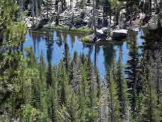
The PCT-TYT junction is just North of Middle Velma Lake, another lake with unique granite terrain making it a great place to take a break and soak up the unique character and feel of the terrain in the Desolation Wilderness.
Video
Just Below Phipps Pass
| Phipps Pass. | ||
| Duration: 2:38. |
Terrain and Scenery
 |
To our South-Southwest a glimpse of Dicks Peak comes into view from just North of, and below Phipps Pass at the ridge running Southeast rising above the South shores of Grouse Lakes. Phipps Pass is off to our Right in the image above, just above the Right edge of the image of the ascending ridgeline. Grouse Lake is down in the bottom of the gorge at our feet. |
View Southeast
 |
| Turning our head further Left we see Mt Tallac capping the ridgeline in far middle-Left background. |
View East
 |
Continuing to shift our gaze Left, now looking almost directly East, maybe a bit South of East we can see a slice of Fallen Leaf Lake peeking through the gap in the mountains to the East (the gap is where Eagle Creek runs through down to Eagle Falls Trailhead and into Lake Tahoe) as we climb high enough to enjoy the expanding views. We are getting long enough views to see East all the way to Freel Peak, the tallest mountain in the Lake Tahoe Basin, rising up in the far Left background over on the Southeastern end of the Tahoe Basin. |
Closer View East
 |
| Northwest Shore of Fallen Leaf Lake peeks through gap in the ridge. |
Phipps Pass to Heather Lake At 10,886 feet Freel Peak (wiki) is the highest peak on the Carson Range of the Sierra Nevada. North of Carson Pass the Carson Range branches off to the East wrapping around the East Shore of Lake Tahoe, while the Sierra Range runs around and above the Western Shore of Tahoe. It's like the two tines of a wishbone joined and centered at Carson Pass. The Sierra and Carson Ranges form the shape of a wishbone wrapping around the shores of Lake Tahoe from their junction point at Carson Pass. Lake Tahoe is situated between the wings of the wishbone, reflecting and complimenting the very best aspects of these sublime mountain ranges wrapping around the Lake Tahoe Basin in its waters, while these very very differently-charactered ranges situate Lake Tahoe within an unparalleled sub-alpine environment. Tahoe Basin Geological History and Information
Looking at Freel Peak above we are looking at the high point of the Carson Range dominating the Eastern shore of Lake Tahoe, viewed from Phipps Pass in Sierra Nevada Mountain Range along the West shore. At 9739 feet Mount Tallac (Wiki) dominates the Western Shore and is the highest peak in Desolation Wilderness.
Carson Range-Freel Peak Access
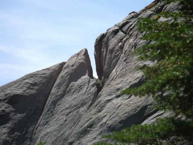
In the Gorge Below Phipps Pass |
|||
 |
 |
||
The larger Grouse Lake on the Left above and the well-worn trail out of Emerald Bay to Grouse Lakes on the Right. That trail above-Right is heading Southeast, down and out of the steep canyon from Grouse Lakes. This looks like a very steep and challenging cross-country trail beyond the easy segment pictured above. A very difficult and dangerous trail. The two Grouse Lakes sit between the great shoulders of granite ridges dropping off below the East Flank of Phipps Peak bracketing Phipps Pass. See the previous page to our North, for a picture of the trail junction down to Grouse Lakes just above Rubicon Lake. Eagle Falls to Grouse Lakes Post up your experiences scrambling from We've got a great update on the trail up to Grouse Lakes from Cayenne, that might be of interest to day hikers and backpackers looking at the route up from Eagle Falls off the Southwest end of Emerald Bay to Grouse Lakes: LOCAL INFORMATION It is also a popular trailhead for a local rock climbing spot call 90 Foot Wall, and yes, its 90 feet, give or take a few feet depending on your specific route up." Phipps Pass to Heather Lake |
|||
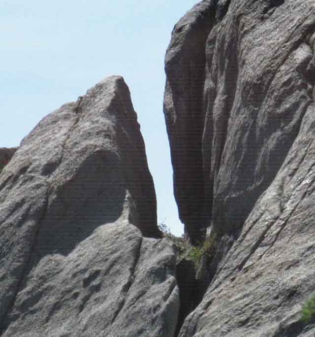
Amazing Granite Rock Formations on the way to Phipps Pass
SMOOTH GRANITE ON THE SOUTH RIDGE ARM
 |
| Above & Below Rock Formation Features on ridge arm South of Grouse Lakes, Desolation Wilderness, Slot. |
 |
| Above Rock Formation Features on ridge arm South of Grouse Lakes, Desolation Wilderness, Slot. |
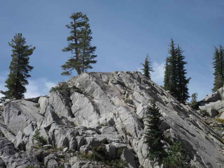 |
Granite along crest line nearing Phipps Pass with thin tree coverage. As we approach Phipps Pass we can see scrambling access above us. Phipps Lake is on the other side of the mountain. |
Sweet Granite & Forest Fringing
 |
Minor ridge formation far below to the Northeast, what I call a Sharkfin formation. Minor formations create huge and complex patterns throughout the terrain. Lake Tahoe is just out of the top of the image. |
Maps Miles Elevations
|
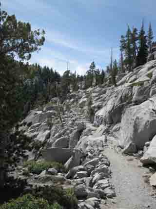
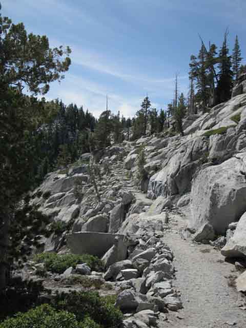
Phipps Pass The Tahoe to Yosemite Trail from Meeks Bay up to Phipps Pass has been a gradual but for the most part an easy climb up to the South end of Stony Ridge Lake. From there a harder Intermediate1 or Hard3 climb brought us through remarkable granite features to Phipps Pass, where we hit the mother lode of granite features and fantastic views. Great expanses of shattered granite walls and great expanses of unjointed granite. Very beautiful. Phipps Pass also marks the beginning of our first downhill section of trail since starting out of Meeks Bay. Yeah! I'm ready for that. It has been one long, gradual climb over 8.88 miles and up 2561 feet of elevation from Meeks Bay to Phipps Pass. Down is now enjoyable... |
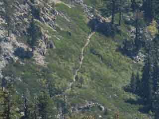
Trail Work Hiking up to Phipps Pass
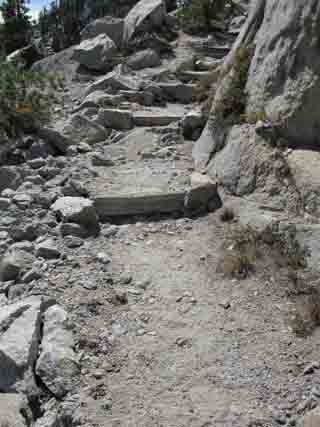
Detail
Nice Trail Work chiseled
into the
East Flank of Phipps Peak
| Trail workers literally broke and chipped this trail into the mountainside. |
 |
Thanks Kids! We can see the great ridge arm extending off to the Left of the image from the main bulk of Phipps Peak on the Right. The low gap ahead between the two is roughly where Phipps Pass is located. To our Left we are getting fantastic views East of the terrain around the Southwest end of Lake Tahoe. |
Phipps Pass View
Looking to our Left hiking South we see stunning views to the Southeast opening up while we are still just a bit North of Phipps Pass. What we are seeing in the image below is the two crests of Maggies Peaks in the middle-Right of the image and Mount Tallac beyond, composing the three prominent crests from the middle to the middle-Right of the image. To our near left we see the rising granite ridge arm that cumulates in Peak 9195. Closer to us and out of view along this ridge sits the big wall in the second and third pictures below. To our near right we can see the descending line of the ridgeline dropping off from Phipps Pass. Phipps Pass is actually a gap between the top of that ridge line to our Right and Phipps Peak. Phipps Pass is more like a channel of trail cut along the flank of Phipps Peak that runs between the mountain's crest and the ridge arms descending Southeast from the crest. Most passes are low gaps between peaks, rather than a channel between mountaintop and ridgeline. Phipps Pass to Heather Lake In the middle distance below the Northwest end of Cascade Lake is seen peeking out from behind the Northern end of Maggies Peaks two main peaks, Peak 8499. Freel Peak decorates the far distant Eastern horizon. Emerald Bay is hidden by the shoulder of Peak 9195, out of sight hidden by the chunk of rock in the middle of the far-Left edge of the image below. Emerald Bay is back there! This view to the Southeast takes in the general terrain of the apron of rock and forest bending around the Southwestern shore of Lake Tahoe (Tahoe is located to the Left, just out of the view of the image below), and the layout of the of the Velma Lakes basin. |
 |
Desolation Wilderness Above we are looking at the long crest line of Maggies Peaks running South, to our Right, in the middle distant Right side of the image above. Maggies Peaks are composed of two closely aligned peaks making up the Eastern limit of the beautiful basin holding the Velma Lakes. Mount Tallac rising in the background is somewhat masking the Southern of the two Maggies Peaks. From our position here we are just getting a glimpse of Maggies Peaks and the most Northeastern end of this nifty Velma Lakes basin where it drains into Lake Tahoe via Eagle Creek. Eagle Creek is flowing through this gap to the Northeast (to our Left from Phipps Pass) out of the basin into Lake Tahoe via Eagle Lake by flowing over Eagle Falls into Emerald Bay far below, all out of our line of sight to the Left. Eagle Creek drains this whole basin containing the Velma Lakes, as well as Fontanillis and Dicks Lakes, with the exception of Middle Velma Lake, which drains West. We will hike past three of these lakes on our way up to Dicks Pass. Eagle Lake and the course of Eagle Creek lay almost directly in front of our position here, but far below us and out of view, being deeply nestled in between the base of the ridge arms descending to the Southeast below Phipps Pass, down to the point where it meets the base of the Northern face of Maggies Peaks Northern peak, which makes up the Southeastern side of the gap. Phipps Pass to Heather Lake |
Looking Northeast
over our
Left Shoulder
 |
Massive wall of shattered granite above the North shore of Grouse Lakes and just North of Phipps Pass. |
 |
Greater detail of the massive granite wall North of Phipps Pass. Wow. What a wall... |
Phipps Pass Posted
 |
North TYT Meeks Bay: Rubicon Lake South TYT to the PCT: S. Flank, Phipps Pass
Hiking to Phipps Pass,
|
||
Hiking up to Phipps Pass is very rewarding. The Southbound hike approaching Phipps Pass features beautiful trails through complex majestic rock and forest topped off by an amazingly fine-jointed massive wall of Granite and with the next ridge topped by a razor back ridge crest of shattered, seemingly sharpened granites. Both the ridges descending off the Southeast flank of Phipps Peak are merely breathtaking. And so is this hike! Phipps Pass is our first pass since departing Meeks Bay, so the backpack is still heavy, the air at 8800 feet still feels thin, and the 8.88 miles from the trailhead still feel like a long ways. I believe that the view is more breathtaking than the difficulty of the hike up to Phipps Pass. That's one of my definitions of a good backpacking deal: the experiences far exceed the work required to engage them. Heck, if the work to get up here is not part of the fun, or you need to get in better shape. Continuing South from Phipps Pass Backpacking 2.62 miles down the South Flank of Phipps Peak we descend to where our Tahoe to Yosemite Trail from the Meeks Bay trail head intersects with the Pacific Crest and Tahoe Rim Trail routes in the North end of Desolation Wilderness. The Tahoe Rim and Pacific Crest Trails run North and South through the heart of the Desolation Wilderness along with our Tahoe to Yosemite Trail route, and we will intersect with the PCT & TRT routes just South of where they cross the Northern boundary into Desolation Wilderness. All three trails coincide to the South 'till the Tahoe Rim Trail breaks off to the Northeast to hike into the Carson Range at the Round Lake/Big Meadow trail junction near Meeks Cabin. The Tahoe to Yosemite and Pacific Crest trails continue South together to the Carson Gap, where we must choose between staying on the Pacific Crest Trail route down to Tuolumne Meadows via Ebbetts and Sonora Passes, or following the Tahoe to Yosemite Trail route to Tuolumne Meadows via Lake Alpine to Saint Mary's Pass.
Next page South |
Backpacking North Trail Guide Rubicon Lake |
 |
Backpacking South Trail Guide |
Backpacker ForumsGeneral Backpacking TopicsPost it on
Phipps Pass has some remarkable features.Add your experiences, comments, or pictures from your backpacking trips across Phipps Pass?Questions?Forum Section
|
North TYT: Rubicon Lake South TYT: S. Flank, Phipps Pass
Trailhead
Contact
Alex Wierbinski

Backpacking Lake Tahoe to Mount Whitney
Your guide to the High Sierra Crest, including the Tahoe to Yosemite, Pacific Crest, and John Muir Trails
