


Virginia Canyon to Tuolumne Meadows Backpacking Map
The
North Yosemite Back Country
abutting
Hoover Wilderness
on the
Pacific Crest and Tahoe to Yosemite Trails
Two
30 minute USGS Backpacking Maps

| PCT -TYT MAPS |
Trail Guide Information |
Tahoe to Whitney Indexes |
Weather, Map Data | ||||||||||||||
| PCT MAPS INDEX Sonora Pass to Tuolumne Meadows |
30 min |
30 min |
7.5 min MAP SOUTH |
Miles |
Trail |
Section |
All Trail Guide INDEX Tahoe to Whitney |
All Miles INDEX Tahoe to Whitney |
All MAPS INDEX Tahoe to Whitney |
Permits |
Resupply |
||||||
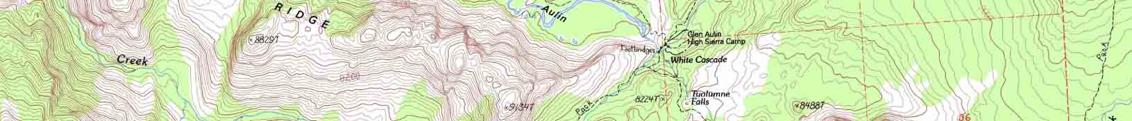
Tuolumne Meadows
Where the Tahoe to Yosemite, Pacific Crest,
and
John Muir Trails
and the
World
all
Come Together
FULLY LINKED
TOPO HIKING MAP
Click the Map
to
SEE
DETAILED MAPS
| North TYT-PCT Bensen Lake to Virginia Canyon |
Click Black and Red DOTZ |
South |
|
| North PCT-TYT Bensen Lake to Virginia Canyon |
Click Black and Red Dots |
South |
Mapology |
||||
MAP NOTE What's important for our general reference purpose is that each side of a square is 1000 meters, or a Kilometer. From my point of view that is 1093.6 yards or .62 of a mile. Diagonal: 1414.22 meters, if my trig is correct. That converts the diagonal distance into 4,639.8 feet or .88 of a mile.
|
Tuolumne Meadows Tuolumne Meadows Resupply Page
Highway 120 Corridor
Highway 395 Corridor
Highway 108 Corridor
|
Location |
Main Features THIS MAP IS UNDER CONSTRUCTION Also See: Tuolumne Meadows 15 minute Hiking Map The routes and their links with the detailed maps have just been laid out. The trails North and South on the John Muir Trail are on the way. After I finish rewriting the completed draft guide from Meeks Bay to Tuolumne Meadows. Stay Tuned. Map Problems Delany Creek now crosses the trail South of the Young Lakes Junction, not to its North as depicted above. The road in the car campground behind the Store and Post Office has been considerably modified from this 1976 map above, and is even different from how it is depicted on the 1994 Vogelsang map as well. The best and most recent maps of the Tuolumne Meadows campground and general facilities are reproduced on the Tuolumne Meadows Backpacker's Resupply Page. Scroll down to see a recent facilities map. Hiking Notes Coming South on the Tahoe to Yosemite Trail I hike the unmaintained trail up from Glen Aulin to the Bridge above Tuolumne Falls. Nifty route. South from the Bridge at Parsons Cabin I cut Left across Tuolumne Meadow to the Post Office. I don't want to hike to the Visitor Center. I want to hike to the Post Office (resupply), Store (beer) and Grill (burger-fries). Hiking South from Tuolumne towards Yosemite Valley on the backwards John Muir Trail I follow the campground to the end, then cut up to the trail. I am generally leaving after an early breakfast at the Grill... Hiking North on the Pacific Crest Trail I hike straight into Tuolumne Meadows, rather than the PCT's crazy route bending around and over to Tuolumne Meadows Lodge, then down to the Lembert Dome parking lot. WTF is up with that? I hike North onto the Tuolumne Meadows Campground road, then I cut up the hill to stop and drop my gear off at the Backpackers Camp before heading down to the Post Office, Store and Grill. |
Mapping, Mileage, |
|
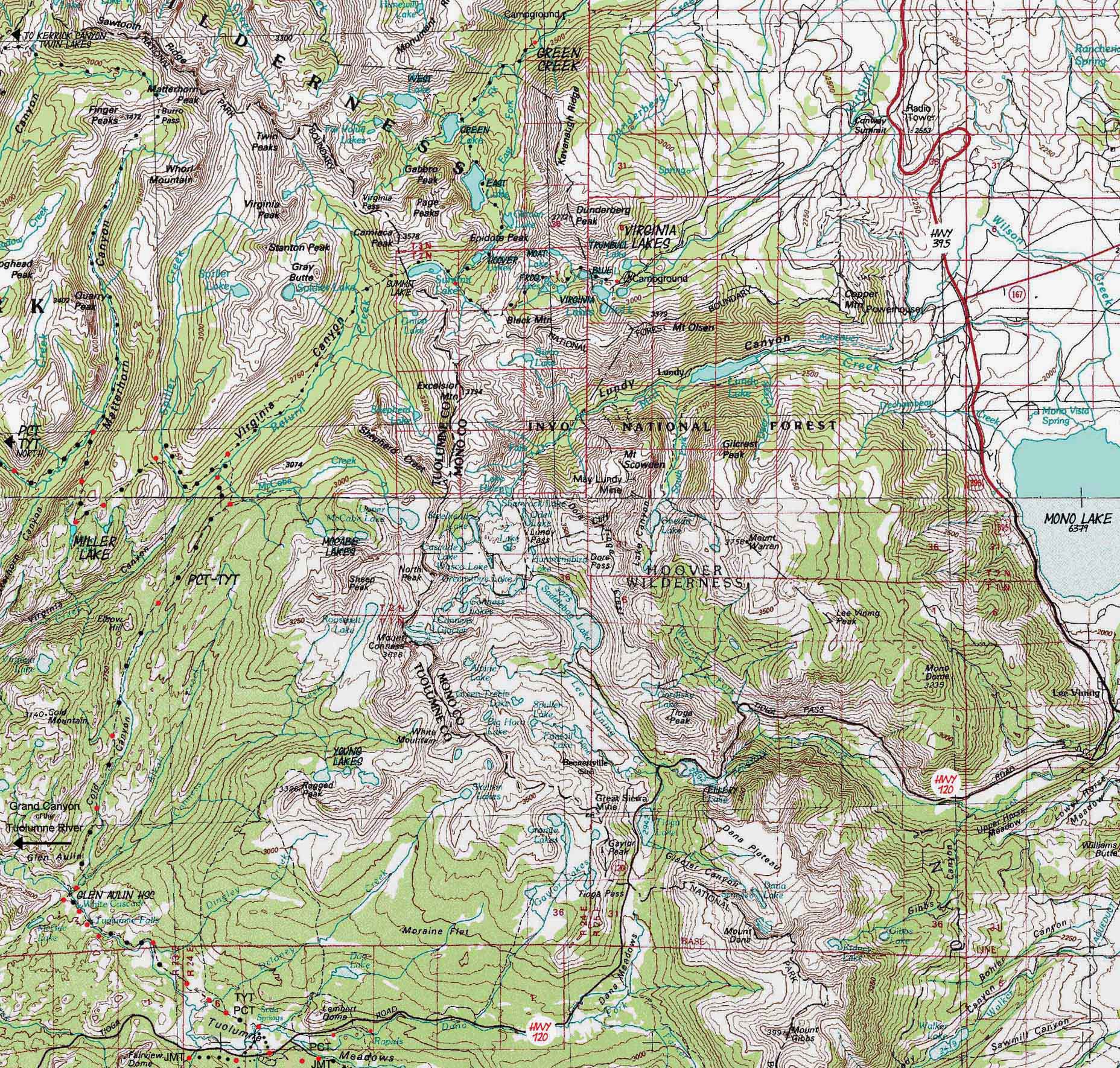
Hoover Wilderness Those would be the Green Creek and Virginia Lakes Trailheads. In the upper-Left hand corner of the map (Northwest edge) we see the trail over to the top of Kerrick Canyon and Twin Lakes. Click that label to be taken to the Bensen Lake to Virginia Canyon Map where we can inspect the whole Bensen Lake Loop out of Twin Lakes. The Sonora Pass to Bensen Lake Map shows the Northernmost entrance into the Hoover Wilderness, the Leavitt Meadow Trailhead.
Mono Lake End of the Tahoe to Yosemite Trail Local Color Now we have to decide if we are swinging through the Valley on our way South, or if we will just pick up the JMT-PCT South into Lyell Canyon. |
Maps Bridgeport, Calif-Nev, 1985 Yosemite Valley, Calif, 1976 Compass Offset scale Contours
Backpacking permitting authority:National Park Wilderness Areas Physical location The North Sierra begins as we hike North from Tuolumne Meadows, and the South Sierra rises to our South. |
North: Bensen Lake to Virginia Canyon South: Tuolumne Meadows Hiking Map
| Elevations | More Information FORUM |
||
Virginia Canyon: 8560 feet McCabe Lake trail junction: 9120 feet Glen Aulin: 7850 feet Tuolumne Meadows: 8591 feet |
Trail Guide Forum |
||
Map Credit |
||
U.S. Geological Survey, Department of the Interior I love the USGS, as you can see from the Tahoe to Whitney Maps. I also dig the NWS, as you can see from our Weather Page. We gotta know the terrain under our feet, and the weather in the sky. These are the basics. In that spirit, let's set you up with the USGS maps sufficient to plan and execute your High Sierra Backpacking Trip with a set of custom backpacking maps. In fact, we can use the USGS to set us up to plan and hike anywhere in the US of A. Move the Map to the Sierras. Or your favorite backpacking spot in the US of A. Navigate the map to the area you wish to locate maps. Click "Mark Point" in the options to see the USGS map grid of the various scaled maps. Select the maps that will help you plan and execute your backpacking trip, set up a directory on your computer named for the trip or location of the maps, and begin downloading those suckers. Open your USGS maps with Adobe Reader. But first, we have to "unzip" the maps. I use 7zip. Custom Maps Printing At least one reader of Tahoe to Whitney has copied and printed out Tahoe to Whitney Maps with success.
That is totally cool for personal and non-profit uses. |