


Backpacking Map
Spicer Meadow Reservoir
to
Sword and Lost Lakes
to
County Line Trailhead
Hiking
South Carson Iceberg Wilderness

| Tahoe to Yosemite Topo Maps |
Guide | Big Picture |
Tahoe to Whitney Indexes |
More Miles and Elevations |
Permits | Weather, Map Data | |||||||||||||||||
Topo Map |
North |
South TYT Jenkins Canyon to Sand Flat |
PCT Highland Creek to Wolf Creek Pass |
Trail Guide Rock Lake to Jenkins Canyon |
Region |
Miles and Elevations Lake Alpine to Saint Marys Pass |
All Miles Tahoe to Whitney |
Maps Lake Alpine to Highway 108 |
All Maps Tahoe to Whitney |
Carson Gap to Lake Alpine |
Kennedy Meadows to Tuolumne Meadows |
Stanislaus National Forest |
|||||||||||
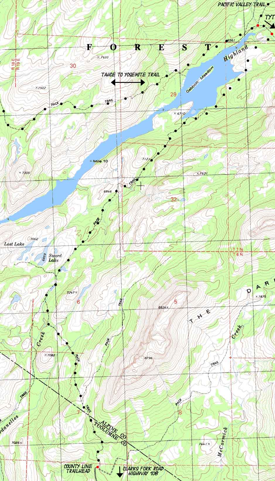
Spicer Meadow Reservoir Backpacking Map
with
Sword and Lost Lakes
| TYT North Alpine Lake to Spicer Reservoir |
To PCT Highland Creek |
TYT South Jenkins Canyon to Sand Flat |
|
| TYT North Alpine Lake to Spicer Reservoir |
To PCT Highland Creek |
TYT South Jenkins Canyon to Sand Flat |
Location |
Main Features: This map connects the Tahoe to Yosemite Trail route with fairly short route from a trailhead off of Clarks Ford Road to the end of Spicer Meadow Reservoir. This is a fairly short and easy way into the Wilderness and onto the Tahoe to Yosemite Trail. It's also the way into a short backpacking out to Lost and Sword Lakes, maybe even on to the Campsites out at the end of Spicer Meadow Reservoir and back to the County Line Trailhead. Here's an interesting description of the hike up to Dardanelles Cone from the end of the dirt road out of the Clarks Fork: |
Mapping Information |
|
Mileages and Elevations
back to Tahoe to Alpine Trail Guide Index back to Meeks Bay trail head |
Map Name
Compass Offset
scale Contours
Backpacking permitting authority
|
next map: last map:
| Elevations | More Information | ||
Lake Tahoe: 6226 feet Meeks Bay Trail head: 6239 feet elevation rise: 400 meters, or 1312 feet |
Trail Guide, Section: Meeks Bay to The Carson Gap Trail Guide, Segment: Meeks Bay Trail head Google Map: All Lake Tahoe trailheads |
||
Map Credit |
U.S. Geological Survey, Department of the Interior: The USGS Move the Map to the Sierras. Select size of Maps you wish to locate. Click "Mark Point" on map to see the USGS map grid of the selected map scale. USGS Topographic |