


Backpacking Map: Carson Gap to Highway 4
Hiking the Tahoe to Yosemite Trail through the Mokelumne Wilderness in the El Dorado National Forest
Two 1x2 degree USGS Backpacking Maps

| PCT & TYT Trail Guide Carson Gap to Highway 4 | TYT Maps Carson Gap to Lake Alpine | SOUTH TYT Map Summit City to Mount Reba |
TYT |
NORTH TYT & PCT Map Carson Pass Region Map | PCT Maps Carson Pass to Ebbetts Pass | SOUTH PCT Map Carson Pass to Ebbetts Pass |
PCT |
This map is a broad overview linking to more detailed information. |
Click the trail route and junctions for links to Trail Guide Pages and Detailed Maps | Northwest |
Southwest |
East |
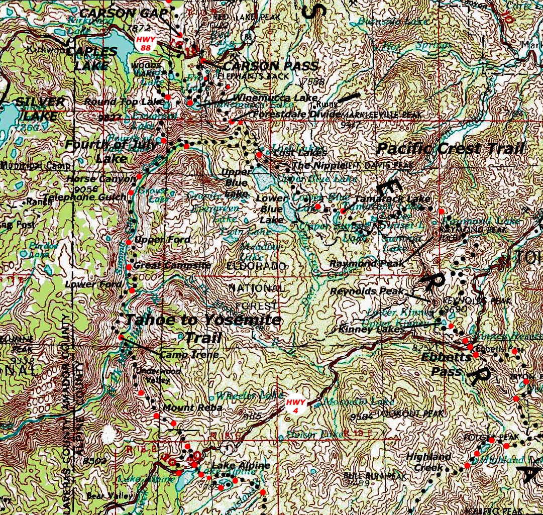
Carson Gap to Highway 4 Backpacking Map: Click the Red Dots for the Trail Guide, Click the Black Dots for Detailed topo hiking maps
North: Meiss Country Roadless Area CARSON PASS TYT South: Summit City to Mount Reba Lake Alpine to Saint Marys Pass PCT South: Carson Pass to Ebbetts Pass Ebbetts to Sonora Pass
|
TYT & PCT North: Meiss Country Roadless Area TYT South: Lake Alpine to Saint Marys Pass PCT South: Ebbetts Pass to Sonora Pass
Map NotesThe left, or West side of this 1x2 degree Backpacking Map shows 24.97 miles along the Tahoe to Yosemite Trail from the Carson Gap to Lake Alpine, plus a little extra on both sides. The right, or East side of the map displays 29.27 miles of the Pacific Crest Trail from the Carson Gap to Ebbetts Pass, in relation to the Western position of the Tahoe to Yosemite Trail. Both trails run through the Mokelumne Wilderness between Highway 88 and Highway 4, but on different sides of the Sierra Nevada Crest. 13 miles of twisty Highway Four separates their Southern Trailheads. The El Dorado National Forest administers the Tahoe to Yosemite Trail through the Mokelumne Wilderness in the Western Sierra Nevada while the Pacific Crest Trail is within the Toiyabe National Forest or its Eastern section of the Mokelumne Wilderness. This map acts as a geographic index for the trail guide and the underlaying detailed maps. Though this map gives you a rough idea of the locations of trail and terrain features you must click the RED DOTS along the Tahoe to Yosemite and Pacific Crest Trail routes to get the most out of this map. The RED DOTS are linked to the related Trail Guide page. The BLACK DOTS along the trail route are linked to detailed maps. Click them to get much better resolution on these sections of trail and a whole lot more information. From each trail guide page you can access highly detailed maps, miles, elevations, more information and images and videos from that location. BIG PICTURE: Carson Pass to Yosemite Big Regional Map Check out the all the maps that cover this section of the Tahoe to Yosemite Trail. |
Higher Detail TYT Route
|
|
Next MAP South on the Tahoe to Yosemite Trail: Lake Alpine to Saint Marys Pass
Main Feature: The Tahoe to Yosemite Trail route |
Between the Carson Gap above Highway 88 to Lake Alpine on Highway 4 This map depicts the most challenging section of the whole Tahoe to Yosemite Trail. This difficult section consists of the 9.5 miles of unmaintained trail between Summit City Creek below Fourth of July Lake, to Camp Irene on the North Fork of the Mokelumne River. Read more about the route options you face hiking South through the Carson Gap. At this particular point you can take either the Tahoe to Yosemite Trail to Lake Alpine, or the Pacific Crest Trail to Ebbetts Pass, both on Highway 4. Taking the option to hike the Tahoe to Yosemite Trail route means that you are going to be crossing unmaintained trail between the Summit City Junction and Camp Irene. This hike is through dangerous terrain that is physically difficult to cross, as well as difficult to navigate through. Alas, this page is under construction. Come back and visit again, and more will be completed... |
Mapping, Mileage, and National Forest Information |
|
More Information Carson Pass to Yosemite: The Big Regional Map
Backpacking Permitting AuthorityNational Forest: El Dorado NF on North side from the Carson Gap down to Camp Irene. From Camp Irene South the Tahoe to Yosemite stays within the Stanislaus NF all the way down to our entry into Yosemite, which lays South of the Kennedy Meadows Pack Station. Wilderness Area: We are within the Mokelumne Wilderness from Woods Lake to the crest of Mount Reba. Physical location: Between Highway 88 near Carson Pass to Lake Alpine on Highway 4. |
Information about this map
L Map Name: Sacramento, 1957, rev 1970, 1x2 degree topographic R Map Name: Walker Lake, 1957, rev 1960, 1x2 degree topographic Compass Offset: Magnetic North is 17 degrees East of true North
scale: 1:250 000 Contours: 200 Feet
Back to Tahoe to Alpine Trail Guide Index
Back to trail head
|
North map: Carson Pass to Echo Summit South map: Hwy 4 to Hwy 108
| Elevations: Tahoe to Yosemite Route | More Information | ||
Round Top Lake: 9360 feet Summit City Creek trail junction: 7440 feet Mount Reba: 8720 feet Lake Alpine: 7303 feet |
Trail Guide, Section: Highway 88 to Hwy 4 (PCT & TY) Trail Guide, Segment: Tahoe to Yosemite Route |
||
Map Credit |
U.S. Geological Survey, Department of the Interior: The USGS Move the Map to the Sierras. Select size of Maps you wish to locate. Click "Mark Point" on map to see the USGS map grid of the selected map scale. USGS Topographic Map Information |