The Trails
Guide
Maps
Miles/Ele
Permits
Resupply
Forum
Current Weather Conditions
Weather Notes
Northern High Sierras
Central High Sierras
Southern High Sierras
Gear
Gear List
Gettin Started
Layering
Discussion
Testing yourself and your gear
Gear Reviews
Approaching
Meiss Meadow
from
Round Lake
Backpacking the High Sierra during the Spring Thaw
Languages
Languages
Trail Arts
The art of walking
Physical Preperation
Trail Skills
The trail
Off the trail
Scrambling
Maps
Navigation
Camp skills
Food
Resupply
Food
Other
Photo Catagories
Trail Stories
Trail Culture
News and Science
Links
Groups
Books
Terms and Conditions of Use
| Trail Guide INDEX |
North Hiking to Round Lake |
South Meiss Cabin and Meadow |
7.5 min Map South Upper Truckee to Carson Pass |
30 min Map Meyers to Carson Gap |
ALL GUIDE PAGES |
Local Weather All Sierra Weather |
all maps index |
from
Round Lake during Spring
through
Rolling-Rising Terrain to Meiss Meadow
 |
|||||||||||
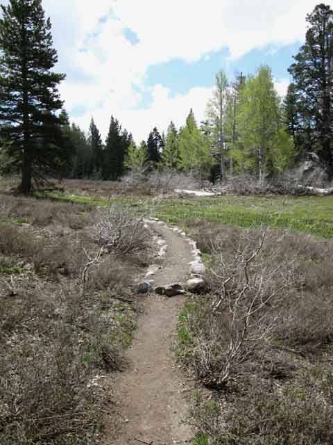
Once we climb above the upper meadow above the Southeast shore of Round Lake we enter zones of forest broken by strips of meadow. The terrain is zebra-stripped by meadow, forest and rock. Mostly meadow and forest, though. The good thing is that once we get above the lower meadow above Round Lake the terrain tilts its angle of ascent towards level, not down to level hiking, but closer. We'll hike over and then back down a couple of low forested rises, with a couple of meadows wedged between them, on our way up to the trail junction in Meiss Meadow.
|
|||||||||||
Meadow and Forest
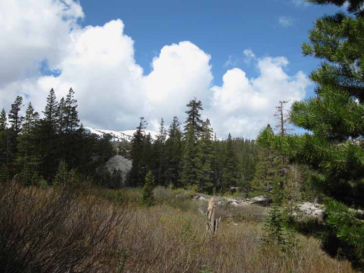
A Web of Seasonal Creeks
Runoff flows everywhere during early June. When the Spring Thaw gets going the ground starts flowing. |
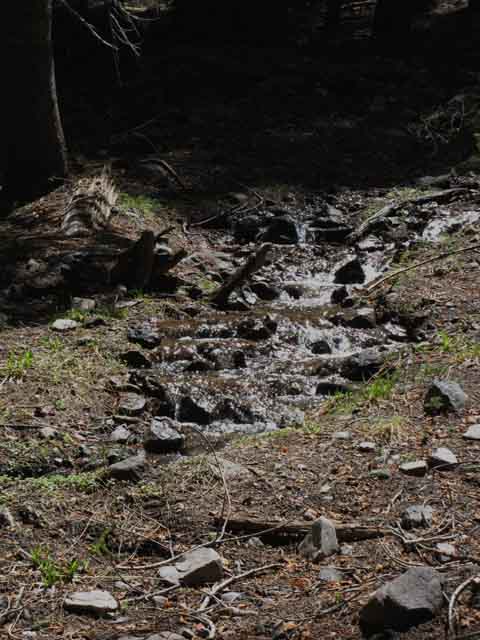 |
Spring Runoff begins flowing everywhere when a substantial snow pack begins melting in earnest. Besides flowing water, the ground is completely saturated in many places. comments |
High Sierra Seasonal Transitions
The Spring Thing The sun is rising up higher in the sky every Spring day, stretching out the length of the day and heating them up, while within the same time frame the Spring storms are gradually diminishing and finally dissappearing. All of these trends naturally draw the High Sierra Nevada Summer backpacker's attention to the mountains. As backpackers we start asking ourselves the perennial question as each Spring approaches: "When will the High Sierra Nevada Backpacking Trails open?" Snow across high mountain passes is our top concern, or I should say it is our concern at the top of the mountain. Spring backpacking offers a wide range of concerns at every level of the mountain, and especially between the mountains, where great rivers of runoff rage. Below the snow-filled mountain passes the trails are emerging from under the snowpack as creeks feeding larger, raging creeks which in turn feed the rivers surging down great canyons between our mountain peaks, and these great thaw swollen rives surge out of the mountains. My point is that the rivers at the bottom of the valleys between Sierra Nevada Mountain peaks can be more dangerous than the slick snow blocking the passes across the tops of the Sierra peaks. All the terrain is collecting, organizing, and transporting this vast runoff into powerful flows that are often running too high and too fast to cross anytime near the peak of the Spring Thaw. The peak of the Spring Thaw is a powerful force of nature, and I don't screw around with crossing rivers when nature is pushing its peak flows. Fording is one of the classic situations where the phrase, "better safe than sorry-or dead" perfectly applies. Saturation in Meiss Meadow and Below Hiking up to Meiss Meadow from Round Lake during the height of a heavy Spring Thaw shows us that flows of Spring runoff waters are not limited to the surface of the terrain. During the height of a heavy Spring Thaw the runoff flows through the soil, moving down mountain without the need for a creek or river. This happens in the terrain below the crescent of Meiss Meadow, wedged in under the surround ring of Sierra Mountains making up the Southern end of the Tahoe Basin.
Crossing these saturated soil conditions pushes us to find the nearest islands of hard rock stepping stones, as each step into these areas of super-saturated terrain threatens to overtop our hightop boots as we sink deep into areas of fully saturated soils. The release of water from the snowpack is not just making the trails run like creeks, super-saturating the soils, and pushing the river levels up. The same engine of life that is driving the wildflowers, the baby chipmunks and tiny chicks is also driving forward the lives of everything that eats them. Remember: Life Eats Itself to Survive. Spring is driving forward the predators as well as the prey. We're more concerned about a creature that combines the worse elements of parasites with those of predators, the mosquito. Birds, squirrels, bears, coyotes, and virtually every living thing in the High Sierra begins feasting and fucking with a hearty gusto and clear joy as this engine of life, this great blossoming of of life is fueled by Spring's rising heat and moisture. The Spring Thaw is a Unique and Powerful Engine of Life that humans have screwed around with, and screwed up. Bad Humans! The power of the Spring Thaw passing through the living terrain is an early expression of the rising energy of Summer, and its progression will tell us about the impending character of the upcoming Summer. The Sun rising higher in the sky is melting the water while its increasing solar energy is powering a dynamic Spring Blooming of Life that climbs the mountainsides in lockstep with the retreating snow. The timing and power of the Spring Thaw determines the character of the impending Summer. Early Spring Sweet Spot Our real question is, "where do I fit into this cycle?" There is a sweet spot for early Spring snow backpackers when the Spring snow storms moderate, the temps rise, but the thaw has not yet begun to surge the rivers or collapse meadow snow cover in earnest. Spring snow backpacking in the High Sierra during this sweet spot is a real delight. Then the Spring Thaw begins in earnest. The Surge It could be the engine of life that restores your spirit, too. Late Spring Sweet Spot As the Spring Thaw tapers down the rivers recede, the meadows and soils harden up and the trails stop flowing like creeks. The mosquito population stops climbing, and the snow remnants in the mountain passes shrink down and become predictable to their enevitable end.
During this period we can still observe the massive blossoming of life, but have to deal with fewer life-threatening obstacles to get there to see it. The mosquitoes are still deadly during this period, but their domination stretches deep into Summer long after the Thaw has ended. Spring to Summer Transition Information
Let Summer Begin! Every Spring Thaw cycle is unique. Its timing, duration, and intensity are dependent on the specifics of each interlocked seasonal transition of the High Sierra climate. I have been observing and tracking the annual transition from Winter to Summer through series of Winter and Spring backpacking trips from the early 1990s until injury in 2006 knocked me down until 2009. In 2009 I resumed my schedule until frostbite in early 2011 knocked me down again. Damn. My normal reporting on the progress of the seasons should resume in 2012 with my 5th Tahoe to Whitney backpacking trip. I frkn hope. In the meantime I've tried to use injury time to build this guide as I rebuild my body, as possible. Meiss Meadow As the Spring Thaw begins in earnest the drainage of the South Upper Truckee is insufficient to carry all of this water away, and it backs up into Meiss Meadow. The weight of the water can be sufficient to push it down mountain through the soil itself, without the help of surface flows. This is an amazing force sculpting the soft terrain from within. We notice this movement of water through the terrain itself while hiking this particular section of trail from Round Lake to Meiss Meadow during the height of heavy Spring Thaw seasons. We plainly see that in many locations the water is flowing down mountain through the saturated soils, pooling up in strange pools in low spots on the terrain while flowing down mountain through the mountain itself. In other places along our trail South, such as the East flank of Raymond Peak and the South flank of Sonora Peak we can see this same type of super-saturated soil actually moving the terrain itself as water and soil all flows down the mountain together during each Spring Thaw. The Bottom Line The beauty of life blooming out of the intensities of Sun and Water during the height of the Spring Thaw make it a dangerous, difficult, and delightful time to backpack the High Sierra. Don't ever let the calendar determine the date of your High Sierra Backpacking trip. Only the conditions on the ground can do that. The key is to avoid dangerous river crossings during the peak of the Spring Thaw. The timing of the peak of the Spring Thaw varies each year, so it cannot be predicted by a calendar, but only by observing the progression of each year's specific Spring Thaw. Don't try to ford rivers that can sweep you to your death. The High Sierra Nevada Backpacker's Weather page is tailored to track the changing water and weather conditions in the High Sierra through the seasons. If there is a better collection of High Sierra Backpacker Weather Resources, I have not seen it. At some point in time the Weather Section of the trail guide will get some more love. |
South Upper Truckee Road TrailheadMeiss Country Roadless Areabetween Round Lake and the Meiss MeadowTrail junction
|
Trail and Terrain
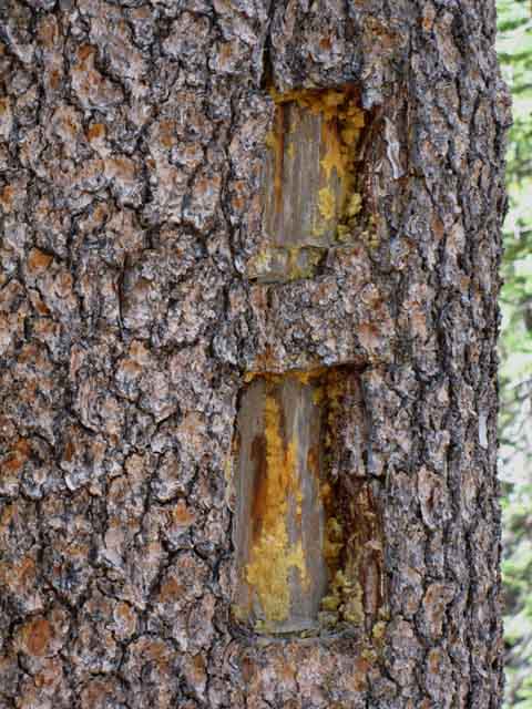
| Classic Blaze marking the Trail. | |||
 |
|||
Blazes adorn trees everywhere there are trees down the length of the trail. Where there are not trees there are Ducks, a stack of differently colored rocks. These blazes along the trail from Round Lake up to Meiss Meadow lay out the basics of the "center" Winter route up to Meiss Meadow from Round Lake. If we can stay on them. Our primairy tool for Winter route-finding will be our compass and fundamental skills and overall terrain knowledge. Blazes will come and go, and they offer occasional clues, but our route finding skills are what will bring us through the center route to Meiss Meadow, with or without ducks. |
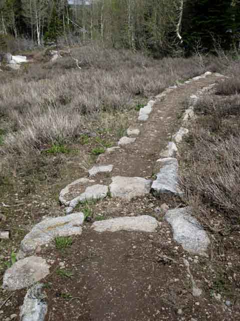
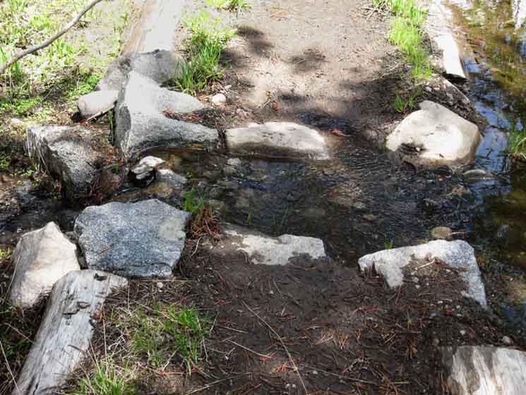
| Build-up to preserve trail as it crosses Spring runoff areas. |
 |
| Where the trails cannot avoid fragile wet super-saturated soils, trails are built up, lined, and made to drain by design. |
This Guide Is set up so that you can add your perspective & experiences here to broaden the trail guide's view of this area. Check the Forum linked to from every trail guide page for more information or to add yours. My perspective alone is insufficient to describe the terrain or the experience. Thus your perspective adds another dimension to the experience. Questions and comments always welcome. General: Backpacker's Forum Home Page Topics: Backpacker's Forum This Location: Meiss Meadow |
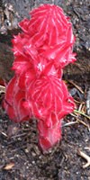
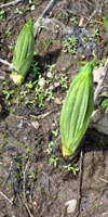
Life Cycle
of
Paper Plants
Wyethia mollis
|
| Close-up. SPROUTING |
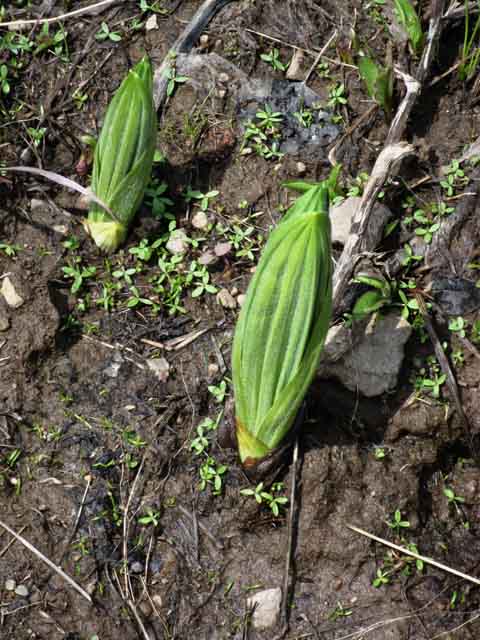 |
Wyethia mollis; Mountain Mule Ears, which I call Paper Plant. |
Life Cycle of Paper Plants
Wyethia mollisMountain Mule Ears blooming in JulyAfter Sprouting in a profusion apparently linked to the availability of water, they bloom. |
Growth
Paper Plants fill every space they can survive. And they are tough. The hike up to Carson Gap looking to the Northeast up a tributairy creek of the South Upper Truckee River at Red Lake Peak to the Northeast. GROWTH and BLOOM |
||||
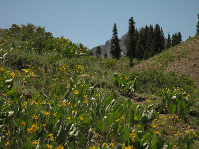 |
||||
In full bloom on the way South up to the Carson Gap South from Meiss Meadow. The biggest field of paper plants I've ever seen covers the South-Southeast flank of Mount Reba, running from the the crest and upper flanks all the way down into Horse Canyon, as far as the eye can see them.
|
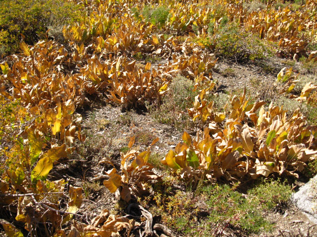
Life Cycle of Paper Plants
Death
Approaching Meiss Meadow
Spring Trail Conditions
between
Round Lake to Meiss Meadow
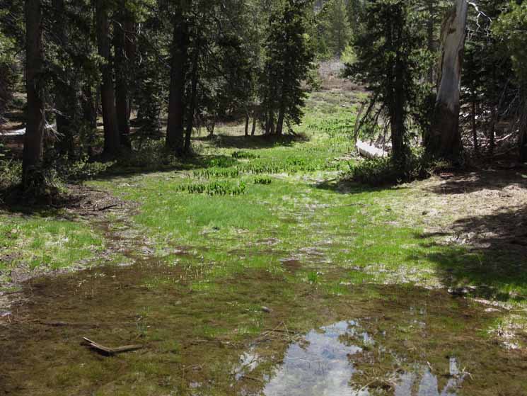
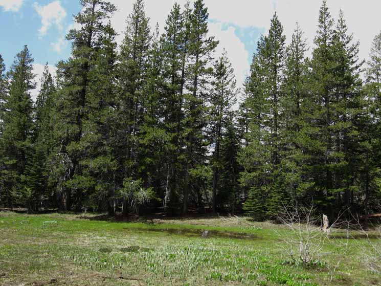
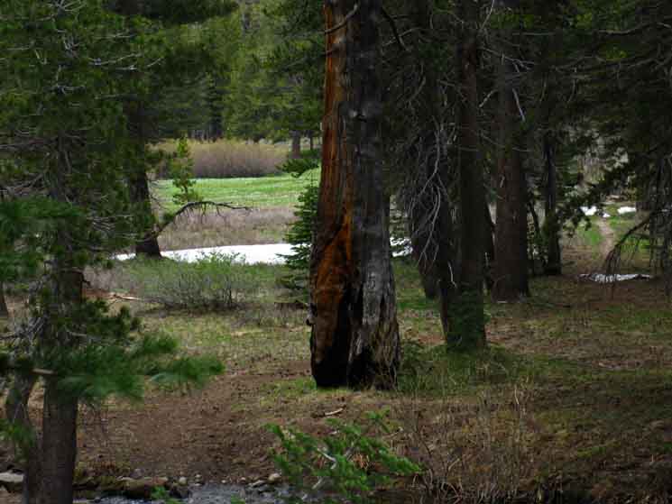
| Last bits of snow giving way to rising temperatures in cool forest shade approaching Meiss Meadow. |
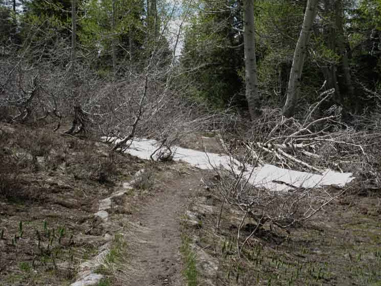 |
Rolling through the last forest rise before Meiss Meadow. |
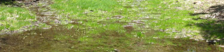
Thaw Flowing through Saturated Soils
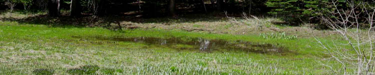
| Water just runs through the soil down mountain from Meiss Meadow during Spring. |
|
And this water pools and collects in flat spots and depressions as it slowly drains and evaporates. This pool is located on the trail, seen exiting the upper left side of the pool. |
North: Hiking Past Round Lake top of page South: Meiss Cabin and Meadow
| The well-designed trails between Round Lake and Meiss Meadow anticipate and accommodate the massive flow of the Spring Thaw here. | ||
 |
||
Above: Trail elevated and reinforced across wet meadow. Below: Though the soils are still saturated and the soggy meadows and trail are dotted with drainage pools after the main body of the Spring Thaw has passed down the mountain, shaded spots in the forest approaching Meiss Meadow still protect remnants of the Spring snows.
|
Lodgepole-Fir Forest
| In the dense forest snow hangs in longer. |
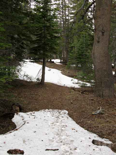 |
| In the afternoon these are soft, so don't get your boot filled with snow! |
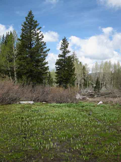
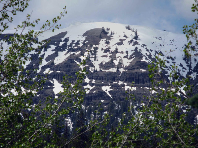
Views of the Tahoe Rim climbing up to Meiss Meadow
Tahoe Rim above North End of Meiss Meadow
The Southwestern Tahoe Rim viewed from the East, approaching Meiss Meadow from Round Lake. Spring snowcap melting away. That's the volcanic face above the North end of Meiss Meadow, maybe a half-mile North of the trail junction near Meiss Cabin. |
||
 |
||
View towards the Southwest approaching Meiss Meadow from above Round Lake. Let's take a look at this face walking South on the TYT-PCT route into the North end of Meiss Meadow.
|
Approaching the Trail Junction
with the
Pacific Crest and Tahoe to Yosemite Trails
| This Tree Marks the Round Lake Trail Junction. | |
 |
|
| I always rest against it for a minute while I watch Meiss Meadow for a while. |
| Almost to the verdant green of Meiss Meadow in the Spring. Green of the Meadow can be seen through the trees. | ||
 |
||
Note the trail on upper-right of frame, visible through the trees. This is the last bit of the trail down to the Junction at Meiss Meadow.
|
North: Hiking Past Round Lake South: Meiss Cabin and Meadow
Round Lake |
The Trail The two miles of trail up from Round Lake to Meiss Meadow starts with an intermediate difficulty climb, levels out briefly, then crosses two low hills before dropping down to the Meadow. I measure the full distance from the South Upper Truckee Road Trailhead and the trail junction in Meiss Meadow at 5.51 miles. But I may be up to a quarter of a mile short. The trail modifications between the South Upper Truckee Trailhead to below the Dardanelles trail junction are significant, and have added at least a quarter of a mile to the original trail's length. (2009 modifications to repair and accommodate damage from bikes, which are allowed in Meiss Country up to the PCT TYT junction at Meiss Cabin.) Check out General Approach to Miles and Elevations. Spring Conditions During the Spring Thaw Meiss Meadow collects and transfers a vast amount of water from the ring of mountains surrounding it down to Lake Tahoe. It is so wet during the height of the Spring Thaw that the ground is completely saturated, and the soil itself acts as a means of passing water down mountain. Depending on when the thaw occurs the trails can harden up anytime from early June to the end of July, depending on elevation, aspect in relation to the sun, how much snow fell during Winter, as well as each season's profile of Spring temperatures and storms. From the first of the Spring thaw until late July there are lots of mosquitoes between the South Upper Truckee Trail head all the way down to Mount Whitney. By the time we hit Tuolumne Meadows the mountains will have dried considerably and the mosquitoes will significantly diminish. But the mosquitoes are still thick when we hike South from Lake Tahoe in Spring For more about mosquitoes in the High Sierras see "High Sierra Mosquito Cycle," and Camp and Trail Skills. Let's keep hiking South and take a look at Meiss Meadow's four-season beauty.
Hiking Information 7.5 Topo Hiking Map 30 min Topo Hiking Map Next page |
Backpacker ForumsHave a great Sierra Nevada route or trip to relate?Post 'em on
Become a Member!Experiences, comments, questions, or pictures about this Section: Let it Rip HERE: Section
|
North: Hiking Past Round Lake South: Meiss Cabin and Meadow
Trailhead
Contact
Alex Wierbinski

Backpacking Lake Tahoe to Mount Whitney
Your guide to the High Sierra Crest, including the Tahoe to Yosemite, Pacific Crest, and John Muir Trails
