

The Trails
Guide
Maps
Miles/Ele
Permits
Resupply
Forum
Current Weather Conditions
Weather Notes
Northern High Sierras
Central High Sierras
Southern High Sierras
Gear
Gear List
Gettin Started
Layering
Discussion
Testing yourself and your gear
Gear Reviews
Backpacking
Showers Lake
to
Meiss Cabin
Hiking
Showers Lake to Meiss Cabin & The Round Lake Trail Junction
Meiss Country Roadless Area
Languages
Languages
Trail Arts
The art of walking
Physical Preperation
Trail Skills
The trail
Off the trail
Scrambling
Maps
Navigation
Camp skills
Food
Resupply
Food
Other
Photo Catagories
Trail Stories
Trail Culture
News and Science
Links
Groups
Books
Terms and Conditions of Use
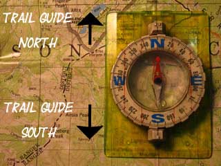
Trail Guide |
NORTH Showers Lake |
SOUTH Meiss Cabin Trail Junction |
Topo Hiking Map Echo Summit to Carson Pass |
|
MILES and ELEVATIONS |
Miles and Elevations INDEX |
Local Weather All Sierra Weather |
All HIGH SIERRA PERMITS |
Tahoe to Whitney on YouTube |
from
Showers Lake
we follow the
Tahoe Rim into Meiss Meadow
Video |
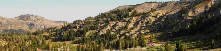
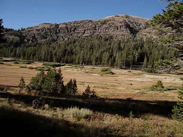
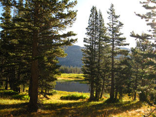
View of the terrain hiking South We get our best view of the terrain South of Showers Lake from the position below, when we were still North of Showers Lake, while hiking South towards it. Showers Lake is off to the Left, out of the middle-Left of the image. |
||
 |
||
In the furthest distance we can see Red Lake Peak dominating the horizon. To its Right, the Southeast, we can see the low Peak rising on the East side of our exit out of the Tahoe Basin through the Carson Gap. Much closer to us I hope you can see the low mound rising out of the far-Left of the frame in the middle of the image? It's on the edge of the Left side of the image beyond the closest granite slabs, surrounded and almost covered by trees. Departing Showers Lake we will hike South through broken meadow and thin forest that we can see composing the terrain beyond that mound, to cross the low ridgeline running across the middle of the image. Can you identify the low ridgeline in the middle distance descending from the Sierra Crest in the image above? We'll see that low ridge behind us as we enter the North end of Meiss Meadow. Scroll up and down from this link to get a few good views of this low ridge looking back from Meiss Meadow. Our Southbound PCT-TYT route South from Showers Lake crosses the Left side of that low ridgeline and then veers right (SE) towards Red Lake Peak on its far side, while at the same time dropping down a couple of hundred feet of elevation through thin and thinning forest progressing into broken meadow sections opening up into the heart of the Meiss Country Roadless Area, the expansive Meiss Meadow. Meiss Cabin and its associated barn will sit off to our Right as we hike up to the Round Lake-Big Meadow trail junction. Meiss Cabin is located in the Southwestern end of its namesake meadow in this special little hiking area, in about the most logical place you could select for a cabin in here. The distance South to Meiss Cabin from Showers Lake is 1.88 miles dropping a total of 280 feet of elevation, though we dropped a bit lower than that on the far side of the low ridge pictured above, before beginning the gentle climb up into Meiss Meadow.
Big Picture The Carson Gap is where our Tahoe to Yosemite and Pacific Crest Trail routes exit the Lake Tahoe Basin. We can see that our exit from the Lake Tahoe Basin, and this short hiking section through the Meiss Country Roadless Area, are both drawing to a close. Our exit from the Tahoe Basin through the Cason Gap is 3.4 miles South of Showers Lake. South of the Tahoe Basin we enter the tiny Carson Pass Management Area circling Carson Pass located at the high point of Highway 88 on our way into the Mokelumne Wilderness on both the PCT and TYT routes. The ridgeline descending to the Right off Red Lake Peak that we'll cross to hike through the Carson Gap up ahead is the Southern part of the Carson Range. I figure the ridge we see to our Right, which is capped along this section by the mass of Little Round Top, is the crest of the Sierra Rim around the West-Southwest shore of Lake Tahoe. The Carson Gap roughly marks where the Southern end of the Carson Range intersects with the Sierra Crest along the West shore of Lake Tahoe. We'll cross the junction between these two mountain ranges at the far Southern point of both Meiss Meadow and the Lake Tahoe Basin. The upcoming trail route from the position in the picture above, North of Showers Lake, will swing down and to the Left through the granite formations on the near-Left side of the image above, to hike around Showers Lake before climbing over the middle-distant low ridge for the drop down, and then up into Meiss Meadow. There we depart the Tahoe Basin. |
South
|
| Hiking Map South Meiss Country Roadless Area |
Echo Summit to Carson Pass Backpacking Miles and Elevations |
Video
Backpacking South
into
Meiss Meadow
from the
North
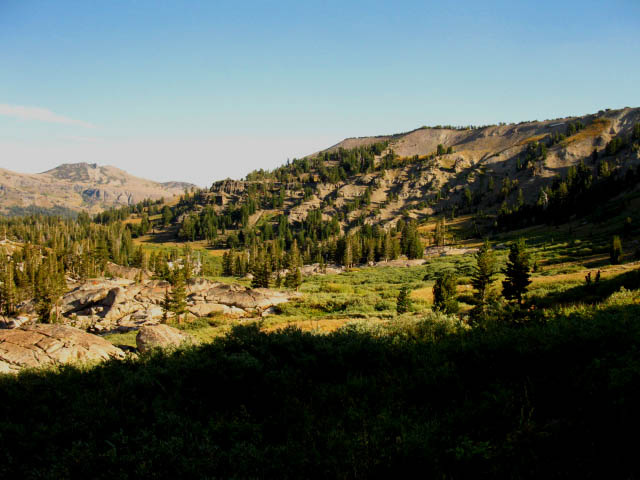
| Shortly after departing Showers Lake and climbing over the low ridge to its South we will enter the Northern limit of Meiss Meadow. | |
First Steps into Meiss Meadow from the North.
|
Cross Country RouteMeiss Lake
|
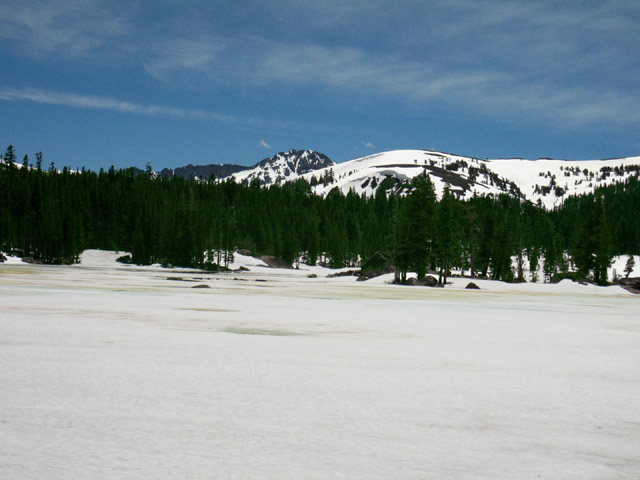
Hiking to Meiss Cabin from Meyers During Winter and Spring
| . | Looking South across Meiss Lake turning to slush in Springtime. | |
 |
||
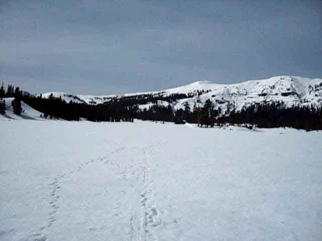
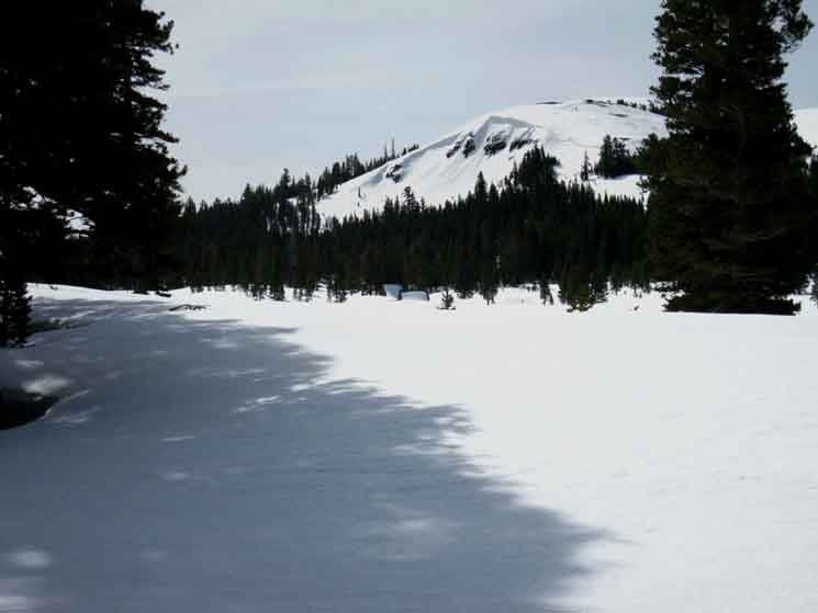
This view is from the Northeastern side of Meiss Lake during a Springtime Snow shoe trip, looking South across Meiss Lake at Round Top to our South, located out of the Tahoe Basin. Round Top is the snow shrouded rock in the distance. Hiking Map South The Tahoe Rim is composed of the near mountain, and the ridges on either side of it. The Tahoe to Yosemite and Pacific Crest Trail routes are buried under snow just past the far side, the South side of Meiss Lake, in the trees in the distance under the Tahoe Rim. Our exit from the Tahoe Basin is at the low point of the ridge descending to the Left of that near low-rounded mountain top. The picture below puts that mountain in context of its position along the Tahoe Rim. To the Right the ridge is bending Northwest towards the high point of Little Round Top, which was the peak behind (to the South) Showers Lake. See the links in the box above this picture for more information on snow camping and cross country travel across the Meiss Country Roadless Area. Below
Note the dark mass of Round Top peeking out from behind the trees on the far Left of the image above, just to the Left of the low rounded mountaintop along the Tahoe Rim. Meiss Cabin is off to the Left of the distant center of the image, on the edge of the treeline a safe distance from the base of the mountains. We can see a channel when open snow bends Left in the distant center-Left of the image. We'll see Meiss Cabin and barn when we make the bend Left into that open channel. More Videos |
Continuing South
into
Meiss Meadow
from
Showers Lake
Peak 9422
 |
| The peak a bit Southwest of Meiss Cabin along the Tahoe Rim. |
Continuing South
Approaching Meiss Cabin
 |
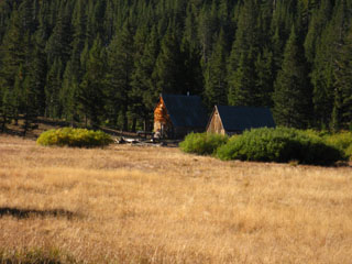
| The roofs of Meiss Cabin and Barn poking through the snow. |
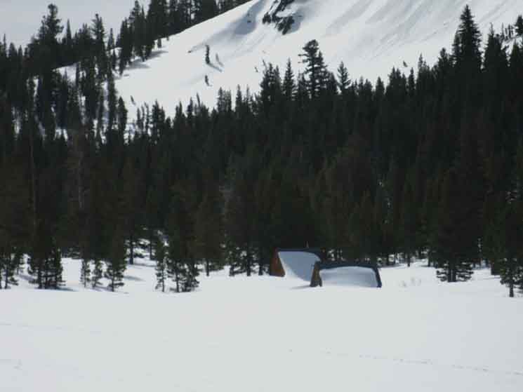 |
| Meiss Cabin and Barn. |
Meiss Meadow
| Looking North, off to the Southbound backpacker's Left, towards Echo Summit. | View to South, and Meiss Cabin, from the Round Lake trail junction. | |||||
 |
 |
|||||
Small Lake to the Southwest of Meiss Lake, just a bit North of the Meiss Cabin. Hiking Map South |
Approaching Meiss Cabin we are coming South to the Round Lake trail junction. The Tahoe Rim trail break off here to the Northeast towards Big Meadow, while the main Pacific Crest and Tahoe to Yosemite routes continue South together to the Carson Gap. |
Looking Northwest towards Showers Lake from Meiss Meadow
Little Round Top is the High Peak on Left
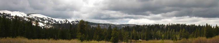
Ominous Clouds blanket our view of the Southwest Tahoe Rim
North: Showers Lake South: Meiss Cabin Trail Junction
Showers Lake to Meiss Cabin |
Showers Lake marks the end of the roller coaster of Tahoe Rim Mountains that worked us hard between the Echo Summit trailhead and Showers Lake. South of Showers Lake we traverse a bowl/flat wedged into the side of the Tahoe Rim through thin forest and opening meadow, crossing a low ridge arm to drop down into forest just a bit to the North of the furthest Northern extent of Meiss Meadow. This first short section of the trail is well-depicted by the picture on the top of this page, though Showers Lake is out of view, just Left (North)of the edge of the image's frame. From the Northern fringe of Meiss Meadow the terrain gently climbs to the Southeast until flattening out into the gentler rise of Meiss Meadow. At the Southern end of Meiss Meadow we turn South to begin our Easy 1 climb up to the Carson Gap. The Long Distance Context Passing South through the Carson Gap marks our final exit out of the Lake Tahoe Basin three and one half days and 41 miles after starting our September trip South from Meeks Bay towards Tuolumne Meadows on the Tahoe to Yosemite Trail route. 7.5 min hiking Topo Map 30 min hiking Topo Map Next page South |
Backpacking Trail Guide North |
 |
Backpacking Trail Guide South |
Backpacker ForumsGeneral Sierra Nevada hiking Trails or Backpacking Topics you pondering? Questions, Comments, and tidbits of information and wisdom all welcome: Post 'em onTahoetoWhitney.Org The Backpacker's Forum. On the Trails Forums you can browse trail locations and add your experiences, comments, questions (or pictures and videos) about hiking South out of the Echo Summit Trail Head. About the Meiss Country Roadless Area.
The Topics Forums deal with everything else backpacking. General comments about the Echo Summit to Carson Pass section of the High Sierra trails, or this particular location: Section
|
North: Showers Lake South: Meiss Cabin Trail Junction
Trailhead
Contact
Alex Wierbinski

Backpacking Lake Tahoe to Mount Whitney
Your guide to the High Sierra Crest, including the Tahoe to Yosemite, Pacific Crest, and John Muir Trails
