The Trails
Guide
Maps
Miles/Ele
Permits
Resupply
Forum
Weather Conditions
Weather Notes
Northern High Sierras
Central High Sierras
Southern High Sierras
Gear
Gear List
Gear Forum
Gettin Started
Layering
Testing yourself and your gear
Gear Reviews
The Tahoe to Yosemite Trail
Backpacking from the
Desolation Wilderness Boundary to Meeks Creek
Hiking to Lake Genevieve on The Tahoe to Yosemite Trail
Translate
Languages
Trail Prep
The art of walking
Physical Preperation
Planning
Trail Skills
The trail
Off the trail
Scrambling
Maps
Navigation
Camp skills
Food
Resupply
Food
Other
Photo Catagories
Trail Stories
Trail Culture
News and Science
Links
Groups
Books
Terms and Conditions of Use
| Trail guide section index |
North |
South TYT Lake Genevieve |
Topo map |
miles & elevations | Miles and Elevations INDEX |
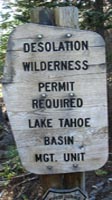
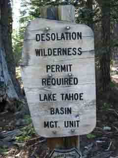
Lake Tahoe Basin Management Unit | All Permits |
All |
Hiking
from the
Desolation Wilderness Boundary
to
Lake Genevieve
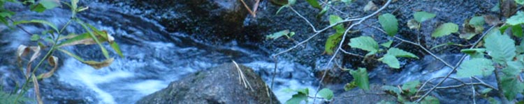
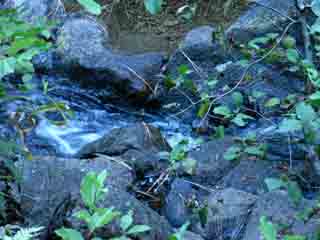
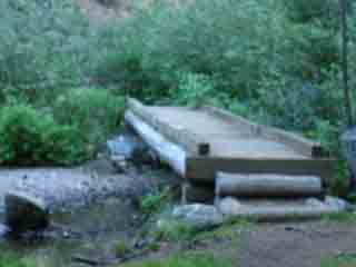
We have another 2.14 very interesting miles of hiking up 680 more feet from the Wilderness boundary to Lake Genevieve. First we'll cross this open ledge wedged in the side of the ridge as we enter a wedge of forest reaching to the top of the valley along Meeks Creek. At the far end of the open rocky ledge we enter a deeply muffled temperate forest before we come upon Meeks Creek and its convenient bridge. We recognize a natural "sweet spot," where the nifty shape of the terrain works with prevailing winds and character of the weather cycle to create a unique zone of biological lushness. Man, we've barely entered the Desolation Wilderness and encounter Natural treasure. Sometimes these "sweet spots" are as simple as a circle of grass growing out of a gravel bed, other times they are crowns of temperate lushness concentrated within terrain complexities and wedged atop an otherwise dry dry strip of forest. The air feels rich with cool mositure within this special zone. The terrain steps up in complexity on the other side of the bridge. The trail bends a U-turn around the hilltop through an interesting close-in section part of an even larger S-curve around and between the hilltops wedged in at the head of the valley we have been hiking into. This S-turn marks the junction of the ridges bracketing the meadow we first passed along the edge hiking through the Meeks Bay Trailhead. The ridge arm we have been traversing up was pinching up to the unique head of this low valley, this little vale, as we climbed. |
Video
Just past the Desolation Wilderness Boundary
Hiking the Desolation Trail, just after crossing the Desolation wilderness boundary,
from Meeks Bay Trail Head. Duration 1:12.
Desolation Wilderness Boundary Elevation Meeks Bay to Dicks Pass Mileage 1.05 miles from the Trail Junction
2.14 miles to Lake Genevieve 6.63 miles to Phipps Pass We are halfway to Lake Genevieve at the Desolation Wilderness boundary. |
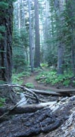
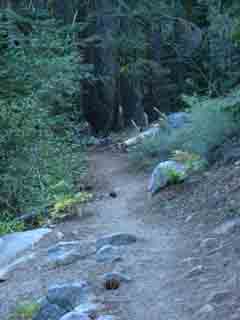
We hike through some nice moist forest after the dry ridge traverse
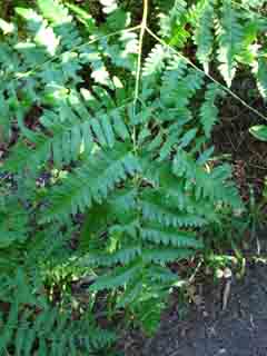
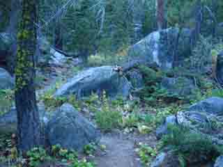
Hiking a mile from the wilderness boundary up to the head of the valley holding Meeks Creek we find ourselves in a protected area under the shadows of the surrounding ridgetops. The physical layout of this location induces shade, Meeks Creek providing water nourishing a dense stand of forest protecting the moist environment supporting the ferns, ivy, and moss which characterizes this little zone as temperate. |
Hiking into Desolation Wilderness |
Ladyfinger Fern |
 |
 |
 |
 |
Forest trail approaching Meeks Creek. |
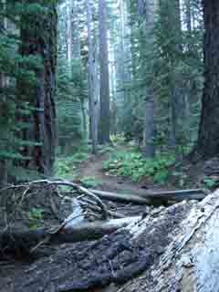
Cool moist location supports a little zone of temperate forest. |
North to the Desolation Wilderness Boundary & Junction South to Genevieve Lake
Last Steps to Lake Genevieve
Desolation Wilderness
A Zone of Moist, Dark, Muffled Temperate Forest
TransitionsThe exposed heat of hiking along the edge of the dried out meadow from the trailhead to the ridge, albeit a meadow that is being filled up with lodgepoles, swiftly transitiones into a shaded hike traversing the ridge arm up towards the head of the valley holding Meeks Creek below Lake Genevieve. At the head of this little vale the junction of its convoluted ridge arms forces the trail to track around and through a neat looping section of trail of close-up wrinkled terrain features. Approaching the head of the valley below Lake Genevieve your body will not fail to notice the transition from hot, dry forest into this small zone that shelters a cool temperate zone, replete with lady finger ferns and ivy, all part of a deep green layer of undergrowth, with a refreshing cool and moist feel to the air. The Roar of Silence This is just the first of what will be many examples of backpacking not just through nature, but through profound transitions created by departing an environment dominated by man into one run by nature. Internal and external transitions. The strains and pains of hiking with a heavy pack are immediately offset by the beauty of the terrain and deeply engaged experiences our packs allow us to access. This experience will deepen where the trail steepens. The trail turns up, significantly steeper than the trail up to Lake Genevieve, for the climb up to Phipps Pass just past the boggy zone off the South shore of Stony Ridge Lake. Then we climb! 1000 feet in 2.11 miles between the South shore of Stony Ridge and Phipps Pass. A Hard3 trail. |
Desolation WildernessMeeks Bay Trailhead Elevation Mileage 1.18 miles South to Lake Genevieve. 5.67 miles South to Phipps Pass. |
Hiking North |
Hiking South |
Backpacker Forums Post it on Welcome to Tahoe to Whitney
Anyone can post text comments in the existing forums, but only members can post up new topics, along with images, maps, and formatting. If you have experiences, comments, questions, trip reports, trail conditions updates or pictures and videos of the Tahoe to Yosemite/Pacific Crest Trail from Meeks Bay to Echo Summit, post up here as an unknown hiker or as a member: Section
|
Trailhead
Contact
Alex Wierbinski

Backpacking Lake Tahoe to Mount Whitney
Your guide to the High Sierra Crest, including the Tahoe to Yosemite, Pacific Crest, and John Muir Trails
