


Backpacking
The Clarks Fork of the Stanislaus River
Hiking
The Tahoe to Yosemite Trail
and
The Pacific Crest Trail
ACROSS the HEART of the CARSON ICEBERG WILDERNESS
7.5 minute USGS Backpacking Topo Maps

| Tahoe to Yosemite Trail MAPS and MILEAGES |
Trail Guide | Tahoe to Whitney Indexes |
More Miles and Elevations |
Weather, Map Data | ||||||||||||||||
| Map INDEX Lake Alpine to Saint Marys Pass |
NORTH TYT Arnot Creek to Jenkins Canyon |
SOUTH |
EAST to PCT Boulder Lake to Pacific Crest Trail |
Miles and Elevations Lake Alpine to Saint Marys Pass |
Region Map Carson Iceberg Wilderness |
Section Lake Alpine to Saint Marys Pass |
Page Jenkins Canyon to Boulder Creek |
All Miles Tahoe to Whitney |
All Maps Lake Alpine to Saint Marys Pass |
All Maps Tahoe to Whitney |
Carson Gap to Lake Alpine |
Miles and Elevations Lake Alpine to Saint Marys Pass |
Sonora Pass to Tuolumne Meadows |
|||||||
Arnot Creek, Disaster Creek, and Boulder Creek Trails with their Trailheads
ALL CONNECTING
the
PCT to the TYT
| TYT TOPO MAP North Jenkins Canyon to End of Clarks Fork Road |
TYT-PCT Topo Map East Boulder Lake to Pacific Crest Trail |
Click Red Dots |
TYT TOPO MAP South Saint Marys Pass |
|
| TYT TOPO MAP North Jenkins Canyon to End of Clarks Fork Road |
TYT-PCT Topo Map East Boulder Lake to Pacific Crest Trail |
Click Red Dots |
TYT TOPO MAP South Saint Marys Pass |
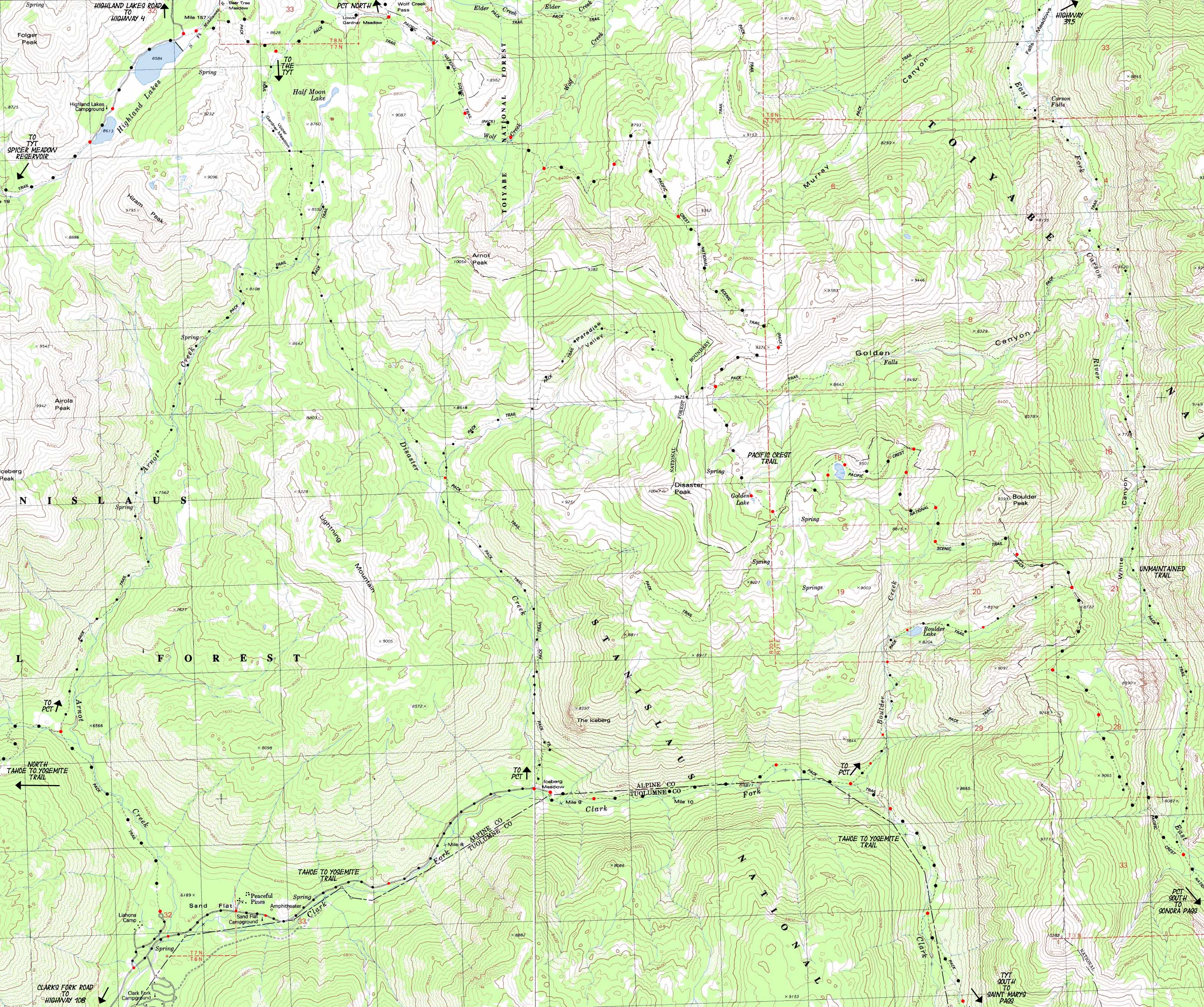
Above is an "Eye Test" for backpackers. Look carefully at the map. If you can not see lots of fantastic loop trips for every skill and fitness level, you need to get your head examined, if not your eyes...
Mapology |
||||
MAP NOTE What's important for our general reference purpose is that each side of a square is 1000 meters, or a Kilometer. From my point of view that is 1093.6 yards or .62 of a mile. Diagonal: 1414.22 meters, if my trig is correct. That converts the diagonal distance into 4,639.8 feet or .88 of a mile.
|
Location |
Main Features Local Hikers The main target of this map are the routes of the Tahoe to Yosemite and Pacific Crest Trails running North and South from their respective trailheads on Highway 4 to our North down to Highway 108 to the South across the Heart of the Carson Iceberg Wilderness. What makes this map effective is its depiction of the totality of three of the four trails connecting the TYT and PCT across the Carson Iceberg, while pointing at the route of the fourth route linking these classic trails. These four routes linking the PCT and TYT allow us to craft a wide variety of looping and "lollypop" backpacking trips around the Carson Iceberg Wilderness, from virtually any direction. The map above hints at our Eastern Entrance via the remote Corral Valley Trailhead, while highlighting Highland Lake's deep road access to trailheads accessing either the PCT or TYT. |
Location |
||||
Main Features Two Trails from the Tahoe to Yosemite Trail to the Pacific Crest Trail
|
||||
TOPO MAP North: Jenkins Canyon to end of Clarks Fork Road Topo Map East: Boulder Lake to Pacific Crest Trail Click Red Dots TOPO MAP South: Saint Marys Pass
Mapping Information |
|
Mileages Lake Alpine to Saint Marys Pass
Trail Guide Highway 4 to Highway 108 Lake Alpine
|
USGS Topo Map Information West Map East Map Compass Offset scale Contours
Backpacking permitting authoritiesTrail Guide Federal Information Federal Information Physical location |
| Elevations | More Information | ||
End of Clarks Fork Road
TYT at Boulder Creek
End of Marked Trail |
Trail Guide Section Trail Guide Section Trail Guide Page Trail Guide Page Trail Guide Page Google Map: North and South |
||
Map Credit |
U.S. Geological Survey, Department of the Interior The
|
Disaster Creek & Clarks Fork
Trailheads