


Backpacking Map
Highland Creek
to the
Clarks Fork of the Stanislaus River
Hiking
The Tahoe to Yosemite Trail South of Spicer Meadow Reservoir across Arnot and Disaster Creek Trailheads along Clarks Fork Road
7.5 minute USGS Backpacking Topo Maps of the Carson Iceberg Wilderness

| Tahoe to Yosemite MAPS and MILEAGES |
TRAIL GUIDE | Tahoe to Whitney INDEXS |
More MILES and ELEVATIONS |
Hit the Trail | WEATHER Map Data |
||||||||||||||||||
| Map Index Lake Alpine to Saint Marys Pass |
North TYT Lake Alpine |
South TYT Clarks Fork |
Miles and Elevations Lake Alpine to Saint Marys Pass |
Region Map Carson Iceberg Wilderness |
Section Highway 4 to Highway 108 |
Page |
Page |
All Miles Tahoe to Whitney |
Topo Map Index Highway 4 to Highway 108 |
All Maps Tahoe to Whitney |
Carson Gap to Lake Alpine |
Sonora Pass to Tuolumne Meadows |
Arnot and Disaster Creek Trailheads |
Highway 4 and Highway 108 Roadmap |
|||||||||
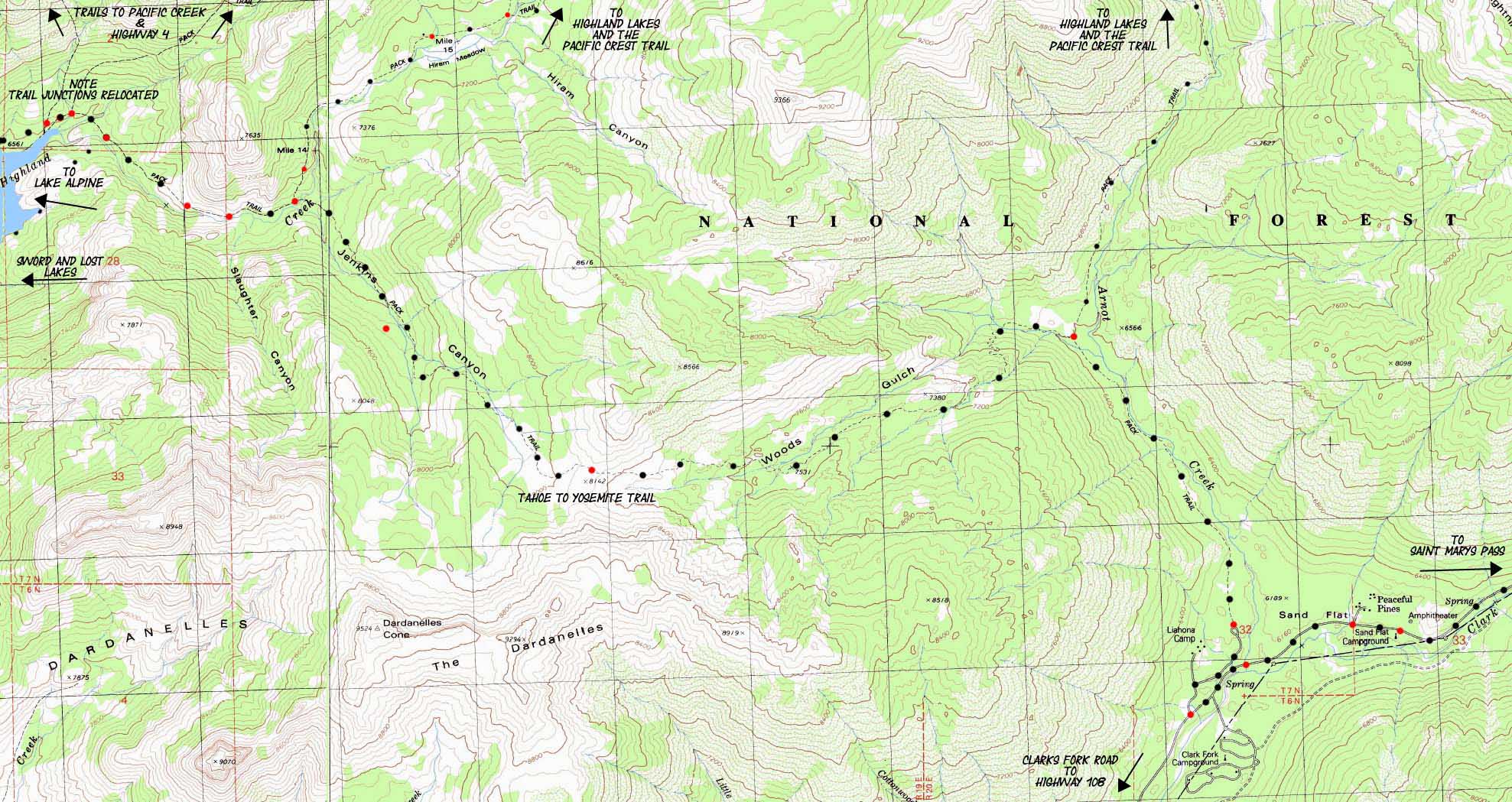
Backpacking 11.65 miles from the Jenkins Canyon Trail Junction at Highland Creek over to Arnot Creek to Clarks Fork Road
| TYT TOPO MAP North Lake Alpine |
Click Red Dots for Trail guide Information |
TYT TOPO MAP South Clarks Fork |
|
TOPO MAP North towards Lake Alpine: Lake Alpine TOPO MAP South towards Saint Marys Pass: Clarks Fork of the Stanislaus River
Mapology |
||||
MAP NOTE What's important for our general reference purpose is that each side of a square is 1000 meters, or a Kilometer. From my point of view that is 1093.6 yards or .62 of a mile. Diagonal: 1414.22 meters, if my trig is correct. That converts the diagonal distance into 4,639.8 feet or .88 of a mile.
|
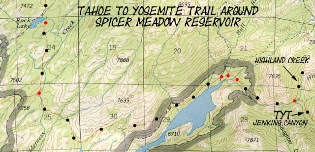
The Current Status of Highland Creek The USGS Topo Maps above are inaccurate. Spicer Meadow Reservoir extends Northeast, covering Gabbot Meadow and extending to the three trail junctions where the trails to Bull Run Creek, Bull Run Peak and Pacific Valley split off from the Tahoe to Yosemite Trail pictured on the far Left, or Eastern side of the map above. The trail across Gabbot Meadow is underwater. The trail South down to what is now the Northeast shore of Spicer on the map above has been moved higher up the side of the canyon as indicated on the map below... Click the RED DOTS on the map below for trail guide information. |
|
Click the red dots on the maps above to see the trail configuration as of October 2011, when the trails depicted above were modified into the new configuration of a single trail junction on the upper end of Spicer Meadow Reservoir. This small section of topo map of the present configuration of Spicer Meadow Reservoir above is from the National Forest Service 1987 Carson-Iceberg Wilderness Map. See the MAP NOTE What's important for our general reference purpose is that each side of a square is 1000 meters, or a Kilometer.
|
Location & Local Loops and Trailhead to Trailhead Backpacking Trip InformationArnot and Disaster Creek Trails |
||||
Arnot and Disaster Creek Trailheads Main Features: About 7 miles North of both the Arnot and Disaster Creek Trailheads these two trails intersect shortly before their now unified route tees out along the 1.12 mile trail connecting the Gardner Meadow Trailhead at Highland Lakes with Wolf Creek Pass on the Pacific Crest Trail. Check out the topo map of Highland Lakes. The Carson Iceberg Wilderness topo map showing the overall relationship beween the Clarks Fork and Highland Lakes. Hiking to the Gardner Meadow Trailhead puts us on the dirt Highland Lakes Road to Highway 4. Try driving between the Clarks Fork Road off of Highway 108 and the Highland Lakes Road off of Highway 4. Jeeze, it's likely quicker to walk through the mountains between these two trailheads than drive around either the Eastern or Western roads between them. Driving the Trans-Sierra Highways
Backpacking Loops as Long Distance Therapy There's nothing like a great trip down the length of the High Sierra Crestline. But a big-assed loop through the Carson Iceberg is a pretty good second choice. I discuss some of our many options for backpacking loops using the web of trails connecting the PCT and the TYT on the previous map page where we were faced with hiking South over Jenkins Canyon to Arnot Creek to the Clarks Fork of the Stanislaus River, or continuing our hike North towards the Pacific Crest Trail via Highland Lakes and Gardner Meadow on the Jenkins Canyon trail guide page. A quick investigation of the loop routes and their miles shows that we can quadruple the miles necessary to hike either the Pacific Crest or Tahoe to Yosemite Trail sections across the Carson Iceberg Wilderness with a loop trip. The shortest loop trips begin at around 15 miles. The longest loops cross the 80 mile mark. Below are the miles for the hikes from the Arnot and Disaster Creek Trailheads, both along the Clarks Fork Road (off of Highway 108) to where these two trails join in Upper Gardner Meadow and their subsequent termination on the trail linking Gardner Meadow to Wolf Creek Pass. Check out this map of Highland Lakes which shows the Northern junction and termination of the Arnot and Disaster Creek trails.
Two Trails connecting the Tahoe to Yosemite Trail with the Pacific Crest Trail in the Carson Iceberg Wilderness
Note on canyon naming along East side of Highland Creek around Jenkins Canyon: Thomas Winnett points out in his classic trail guide, The Tahoe to Yosemite Trail, that the series of ridges dividing Highland Creek from Arnot Creek are misnamed on the 15 minute USGS maps. This error has apparently been corrected since Winnett pointed it out in 1970, as the canyon leading out of the Highland Creek drainage is now labeled as Jenkins Canyon on the USGS 15 minute topo maps. For Winnett's comments, see page 79 of the 1987 5th edition.
|
||||
Contextual Information
Big View Road Map |
Forest, Permit, Mapping, and Miles Information |
|
Miles and Elevations
Trail Guide Information Highway 4 Guide Page
Human Fuel-UP When you drive out to your Clarks Fork Road Trailhead for a nice backpacking trip, be sure to begin and end your hike with a great breakfast (start of hike) and dinner (end of hike) at
MAP NOTE What's important for our general reference purpose is that each side of a square is 1000 meters, or a Kilometer. |
USGS topo maps information West Map: Spicer Meadow Reservoir, Calif, 1979, USGS 7.5 minute Topographic East Map: Dardanelles Cone, Calif 1979, 7.5 minute USGS Topographic Scale Contours East Map: Dardanelles Cone, Calif, 1979, USGS 7.5 minute Topographic Scale Contours Compass Offset
Backpacking permitting authorityStanislaus National Forest Wilderness TahoetoWhitney Contacts Stanislaus National Forest National Forest Wilderness Area information
|
|
TOPO MAP North towards Lake Alpine: Jenkins Canyon trail junction in Highland Creek TOPO MAP South towards Saint Marys Pass: Clarks Fork of the Stanislaus River
| Elevations | More Information | ||
High Point between Jenkins Canyon and Wood Gulch Arnot Creek Trailhead End of Clarks Fork Road TYT and Boulder Creek |
Trail Guide Section Trail Guide Page Google Map |
||
Map Credit |
U.S. Geological Survey, Department of the Interior The
|
Calvalcade of Trailheads
Disaster Creek & Clarks Fork Trailheads