


Backpacking
Boulder Lake
Connecting
the
Pacific Crest and Tahoe to Yosemite
in the
Carson Iceberg Wilderness
7.5 minute USGS Backpacking Map

| Tahoe to Yosemite Trail Maps and Mileages |
Pacific Crest Trail Maps and Mileages |
PCT Miles |
PCT Maps |
All Maps and Miles |
Weather, Map Data | |||||||||||||||||
| MAP North TYT Jenkins Canyon to Clarks Fork |
MAP |
MAP Section Hwy 4 to Hwy 108 |
Miles and Elevations Lake Alpine to Saint Marys Pass |
Trail Guide Boulder Lake |
North PCT Murray Canyon to Boulder Lake |
Here Boulder Lake Trail | South PCT Boulder Lake to East Carson |
Miles and Elevations Ebbetts Pass to Sonora Pass |
Here Swampy Lake to Boulder Lake Junction |
South Boulder Lake to Sonora Pass |
All Maps Tahoe to Whitney |
All Miles Tahoe to Whitney |
map info | |||||||||
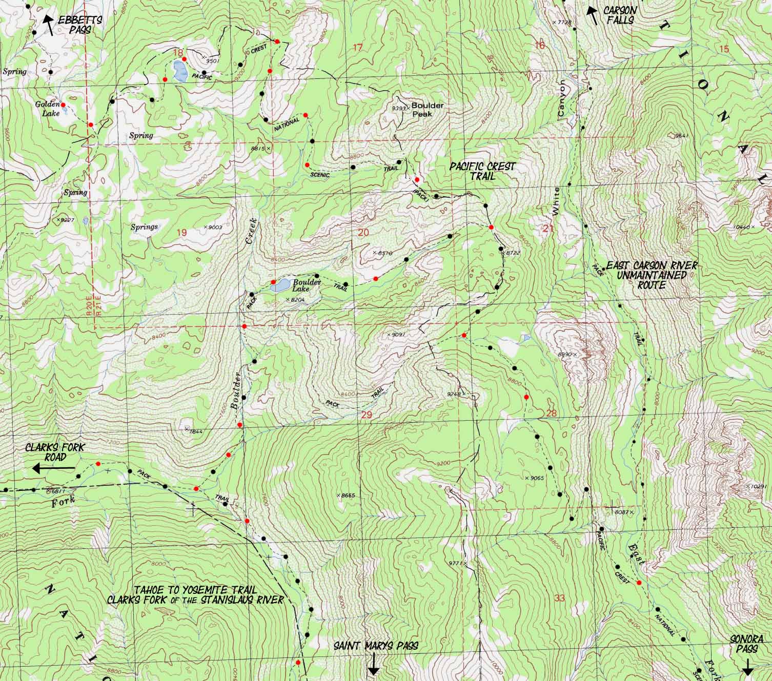
Boulder Creek and Lake
South Carson Iceberg Wilderness
This 2.74 mile long trail connects the Tahoe to Yosemite Trail with the Pacific Crest Trail
| PCT North Asa Lake to East Carson River |
Click RED dots | PCT South Boulder Lake to Sonora Pass |
| TYT North Jenkins Canyon to Clarks Fork |
TYT South Saint Marys Pass |
|
| PCT North Asa Lake to East Carson River |
Click RED dots | PCT South Boulder Lake to Sonora Pass |
| TYT North Jenkins Canyon to Clarks Fork |
TYT South Saint Marys Pass |
Location |
||||||
Main Features If you've been following the guide and maps down the TYT or PCT to the Boulder Lake link between the two trails you can see that this is the fourth, Southernmost, and shortest of the four connecting trails between the Tahoe to Yosemite and Pacific Crest Trails across the Carson Iceberg Wilderness. South of here the trails again come together, more or less, where they exit the Carson Iceberg onto Highway 108 less than a mile apart.
|
Mapping Information |
|
Mileages and Elevations Boulder Lake Trail 2.56 miles South of the Clarks Fork Trailhead at the end of the Clarks Fork Road we hike to the Boulder Lake trail junction. From here we can continue South up the Clarks Fork of the Stanislaus River towards Saint Marys Pass or hike up to the PCT above the East Fork of the Carson River via Boulder Lake. Trail Guide Pages Hike the Boulder Lake trail up to Boulder Lake and on to the Boulder Lake trail junction on the Pacific Crest Trail. MAP Miles and Elevations Boulder Lake East from the TYT to the PCT Boulder Lake trail jnct 6960 feet 0 miles
Boulder Lake 8160 feet 1.39 +1.35 PCT @ Boulder Lake trail jnct 8650 feet 2.74 The total distance between the Boulder Lake Junction on the Tahoe to Yosemite Trail to the Boulder Lake Junction on the Pacific Crest Trail is 2.74 miles. The elevation difference is 1690 feet. This is the shortest of all 4 trails linking the Tahoe to Yosemite Trail with the Pacific Crest Trail through the Carson Iceberg Wilderness. South on the Tahoe to Yosemite Trail Boulder Creek to Saint Marys Pass Miles and Elevations |
USGS Map Information Map Name Compass Offset
scale Contours
Backpacking permitting authority:National Forest Wilderness Area: Carson Iceberg WildernessPhysical location:Approaching Highway 108 from the Northwest
Back to Back to
|
next map: last map:
| Elevations | More Information | ||
Boulder Creek at the TYT
Boulder Lake
Boulder Lake Junction on the PCT |
Trail Guide Section Trail Guide Page Trail Guide Page Trail Guide Page Google Map: North and South |
||
Map Credit |
U.S. Geological Survey, Department of the Interior: The USGS Move the Map to the Sierras. Select size of Maps you wish to locate. Click "Mark Point" on map to see the USGS map grid of the selected map scale. USGS Topographic |
Disaster Creek & Clarks Fork Trailheads