


Permitting Authorities in the High Sierras
The National Forests and Wilderness Areas between Lake Tahoe and Mount Whitney
The Trails
Guide
Maps
Miles/Ele
Permits
Current Weather Conditions
Weather Notes
Northern High Sierras
Central High Sierras
Southern High Sierras
Gear
Gear List
Gettin Started
Layering
Discussion
Testing yourself and your gear
Gear Reviews
| Home | North: Lake Tahoe Basin | Ranger Districts | National Forest-Wilderness list | Yosemite | Trailhead permits | Endless Backpacking | Map |
| El Dorado NF | Stanilaus NF | Humboldt-Toyiabe NF | PCT or TY? | National Forests map | Contacts |
(Note: This page, and the subsequent pages in this section, are under construction)
How the High Sierras are Administered
|
||||
National Forests and Wilderness Areas |
||||
| Wilderness/National Forest Link List | ||||
The Sierra Crest and the adjacent mountains and forests between Lake Tahoe and Mount Whitney are divided into National Forest administrative units. (map below) The Wilderness Areas along the way are contained within, and split among, these National Forest administrative units. The difference between National Forests and Wilderness can be profound. National Forests allow extreme degrees of mechanical intervention and expoltation, while Wilderness Areas only allow limited muscle-powered incursions. In any case, if you do a backpacking trip along the Sierra Crest, you will need to get a permit from the Ranger District of the National Forest your trip begins in. So far I have only completed the Permitting Authorities from Lake Tahoe to the Stanislaus National Forest. Stay tuned as I complete the Forest information for the Southern Sierrras as the Trail Guide continues South. |
||||
Ranger Districts issue Permits |
Yosemite National Park |
|||
The National Forest administrative units are sub-divided into Ranger Districts. Backpacking permits are obtained from the Ranger District of the National Forest where you begin your backpacking trip. All long distance backpacking permits are obtained from the Ranger District of the National Forest the trip orginates in, no matter how many National Forests or Wilderness areas are subsequently traversed. Ranger District issued permits are honored by all of the subsequent National Forests and Wildernesses you will backpack through. But sometimes, there have been exceptions to this rule.
The Mount Whitney Zone has in years past instituted "sticker policies," when Ranger Districts issuing permits that exited through the Whitney Zone were required to obtain and attach special "Whitney Zone" stickers to every permit they issued. God knows what restrictions the various federal entities along the trail will come up with from year to year. To assure your trip is not delayed by permitting problems, I highly recommend that everyone planning a long distance backpacking trip beginning anywhere between Lake Tahoe and Mount Whitney call the Ranger District of the trail head they plan to start their trip from, and inquire about any special restrictions in force and pre-order their permit at least a month in advance of their departure date. This will prevent a lot of problems. The permitting agency will take all of your information over the phone, fill out a permit for you, and mail it to you. Because it is really a drag to be delayed by permitting problems at the trail head, especially after all of the time, expence, and preparation required to put together a long distance backpacking trip, you really should order your permit early. The Ranger Districts are real good about getting permits in the mail a couple of times a week. Many Ranger District stations also have boxes outside their office where they will leave permits for early birds trying to hit the trail head early, if you call and ask. |
If you are one of the too many backpackers who are planning to start your backpacking trip from inside of Yosemite, especially Tuolumne Meadows, you should know that the issuance of permits is highly restricted during peak Summer periods. This is also true of the Hoover Wilderness East of Yosemite This is to prevent too many people from crowding into the backcountry at the same time. Therefore it is wise to secure a reservation for any high season backpacking trips you plan in Yosemite. If you do not have a reservation you may be forced to wait for up to a couple of days before a permit becomes avaiable. I have seen 25 backpackers lined up at the Tuolumne Meadows permit office early in the morning before the office opens, seeking one of the few backcountry permits becoming available that day. If you cannot get a reservation, you might consider ending, rather than beginning, your backpacking trip in Yosemite. All of this Yosemite permit hassle can be avoided by beginning your backpacking trip in Yosemite from outside Yosemite, from a trail head where there is no wait for permits. It is only a couple of days hiking into the Yosemite backcountry from the Emigrant Wilderness, and a few more days to Tuolumne or the Valley, from literally dozens of awesome trail heads in the National Forests just outside of Yosemite National Park. Four of my favorite trips ending in Yosemite begin in; Lake Tahoe (150 miles to Toulumne Meadows), Sonora Pass (75 miles to TM), Little Antelope Pack Station, (110 miles to Tm, access near Walker, Ca, on hwy 395), Twin Lakes (near Bridgeport, Ca, Hwy 395, maybe 40 miles to TM. I'll have to look this up in my notes). Don't make the mistake of believing that Yosemite is the limit of Sierra Beauty. It is the center of Sierra beauty, and as such attracts enough traffic to diminish itself with congestion. Approaching Yosemite from outside the Park will highlight the particular geological and natural characteristics of your approach route, which will lead you to a greater appreciation of the Sierras, the Yosemite region, and a deeper understanding of yourself. |
|||
Obtaining a Permit at the Trail Head |
||||
Many of the remote trail heads in National Forests in the Northern Sierras have permit pads and pens in a box at the trail head for the convenience of local backpackers. Call the Ranger District of the trail head your trip begins in for specific information. Many of these trail head permits are stamped with restrictions, such as the "this permit is only valid in" that particular trail head's National Forest or Wilderness Area. I believe these stamped permits are a device to prevent people from taking these trailhead permits and attempting to use them in Wilderness Areas where permits are restricted. Call the Ranger District of the trail head you are interested for more information. If you are planning a long distance backpacking trip across restricted permitting areas, such as The Yosemite National Park, or your trip hooks into The John Muir Trail coming down from Lake Tahoe, as I often do, you must have a valid permit issued by the Ranger District of your originating trailhead. Don't depend on trail head permit boxes for backpacking trips that cross into different, or restricted, permitting authorities. Although it is easy to obtain a thru permit outside of the restricted areas, even during the "high season," you should understand that Yosemite is trying to hard to restrict unlimited access to Yosemite and the John Muir Trail by restricting the number of permits they issue, and surrounding Forests are limiting the range of self-issued trail head permits. As I said above, they are often restricted. So you should order your permit from your trail head's Ranger District over the phone and have them send it to you well before your departure date. This is especially true for long distance backpacking trips that will cross into high-traffic areas. |
||||
Endless Trips |
||||
There are literally thousands of short and medium length backpacking trips that can be cut out of the Sierra Crest Trails between Lake Tahoe and Mount Whitney either following the Crest, or incorporating a section of the Sierra Crest. For instance, you can hike a section or two of the Tahoe to Whitney trail each year, until you have walked the entire length of the Sierra Crest. Though the routes along the Sierra Crest are this site's main focus, every trail junction and subordinate trail head along the Sierra Crest is also described, and is a viable option for a short or medium distance backpacking trip along the Sierra Crest. Each of these trails can bring you onto, and off of, the Pacific Crest, John Muir, or Lake Tahoe to Yosemite trails on your own personal custom designed excursion. If you are using this site to put together your own epic trips along and around The Sierra Crest, you will have to obtain permits for each trip from the proper Ranger District in the National Forest's Ranger District where your trip begins. I have included the following list of the National Forests, Wildernesses, and Ranger Districts that administer the trails between Lake Tahoe and Mount Whitney along the Sierra Crest to make this easy. If I did my job well you should be able to easily figure out how to obtain the permits and information you will need to plan and successfully execute your trips into, or across, the most remote, as well as the most congested, permit areas during the high season. You may have to begin your trip from outside the congested areas, but you will get in and through. The following list will bring you to all the information you need about all of the Permitting Authorities between Lake Tahoe and Mount Whitney. Backpack the High Sierras! |
||||
| Backpack from Lake Tahoe to Mount Whitney! | ||||
|
||||
 |
||||
 |
||||
Congratulations to Ranger Rick Sayer and his new wife Suzanne. They were married on Aug 13, 2009 in Big Pete Meadow with the trail crew as wittnesses. |
The Evolution Valley Ranger | |||


The National Forests and Wilderness betweenLake Tahoe and Mount Whitney |
||
North Sierras National Forests |
||
Lake Tahoe Basin Administrative Unit: Desolation Wilderness, Meiss Roadless area El Dorado National Forest: W Moklumne, Carson Pass Area Toyiabe National Forest: E Moklumne, E Carson Iceberg, borders Emigrant Wilderness on East, and NE border of Yosemite Stanislaus NF forest: SW Moklumne, W Carson Iceberg, Emigrant Wilderness, and NW border of Yosemite |
||
North Sierras Wilderness |
||
INFORMATION |
MAPS | MILES |
El Dorado NF, Mokelumne Wilderness Toiyabe NF, Mokelumne Wilderness Stanislaus NF, Mokelumne Wilderness Stanislaus NF, Carson Iceberg Wilderness Toiyabe NF, Carson Iceberg Wilderness |
Mokelumne |
|
The Center of the SierrasYosemite National Park |
||
| more to come...stay tuned! | ||
South Sierras
coming soon!
| Scroll up for National Forest Link List |
 |
Map Credit: Forest Service, Pacific Sorthwest Region, "A Guide to National Forest Wilderness in California."
top of page
This page is under construction.
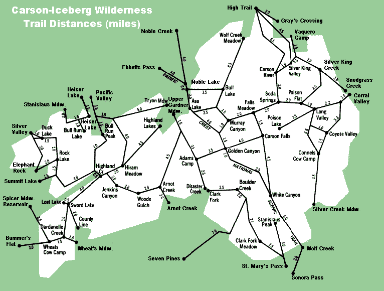
Ebbetts Pass to Sonora Pass: The PCT Route
The PCT at Ebbetts Pass is within the Toiyabe NF, and enters the Carson Iceberg Wilderness from Asa Lake and stays within this wilderness until it reaches the gap in the mountains between the headwaters of the East Carson River and Wolf Creek Lake. Shortly past Wolf Creek Lake the PCT leaves the Toiyabe NF and enters the Stanislaus NF, which administers the Sonora Pass trail head.
Lake Alpine to Saint Mary's or the Sonora Pass: The Tahoe-Yosemite Route
The backpacker continuing down the Tahoe-Yosemite from Lake Alpine on the Silver Trail almost immediately enters the Carson Iceberg Wilderness. The classic Tahoe to Yosemite route remains in the Stanislaus NF, Carson Iceberg Wilderness, Summit Ranger District, all the way to wilderness boundry at Saint Mary's Pass, where the brief remaining bit of the trail lays within the Stanislaus NF.
Sonora Pass to Tuolumne Meadows: Various Routes
The PCT Route
The backpacker on the PCT route
The Tahoe to Yosemite Route
This is the part of the Tahoe to Yosemite Trail that I believe is crazy. After exiting the trail at the Saint Mary's trail head on Highway 108 just West of Sonora Pass, this route follows Highway 108 for 10 miles to Kennedy Meadows! Are you kidding? I have never been into walking extended lengths on a very narrow twisting road with serious blind corners. It's just crazy.
This route remains within the Stanislaus NF, Summit Ranger District through Kennedy Meadows, entering the Emigrant Wilderness just past Relief Reservior, to Bond Pass, where the route exits the Stanislaus NF, Emigrant Wilderness to Enter the Yosemite National Park.
From Bond Pass to Tuolumne Meadows the Tahoe to Yosemite trail remains within the Yosemite National Park.
Alex's Favorite route
After exiting the Stanislaus National Forest's Carson Iceberg Wilderness at Sonora Pass, you just walk across Highway 108 at Sonora Pass and enter the Stanislaus National Forest's Emigrant Wilderness, Summit Ranger District.
Trail Arts
The art of walking
Physical Preperation
Trail Skills
The trail
Off the trail
Scrambling
Maps
Navigation
Camp skills
Food
Resupply
Food
Other
Photo Catagories
Trail Stories
Trail Culture
News and Science
Links
Groups
Books

