

High Sierra
Backpacking
Trail Guide
Forums
Sierra
Weather
WeatherNotes Northern
Sierra Weather
Gear
The Tahoe to Yosemite Trail
Hiking to Rubicon Lake
Backpacking out of the Meeks Bay Trailhead in Desolation Wilderness
Languages
Trail Skills
Mountain
Safety
Food
Planning
Trail Arts
More
Information
Social
| Trail Guide Section INDEX |
North |
South TYT Phipps Pass |
Topo |
Miles & Elevations |
Miles & Elevations INDEX |
All |
Desolation Wilderness Backpacker
Meeks Bay
Just the Hard Facts |
| Meeks Bay to Dicks Pass 15 minute Backpacking Map |
Desolation Wilderness 30 minute Backpacking Map |
Meeks Bay to Echo Summit
Backpacking Miles and Elevations
Video
Hiking to Rubicon Lake
| Arriving at Rubicon Lake. | ||
| Duration 1:13. |
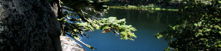
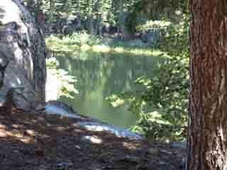
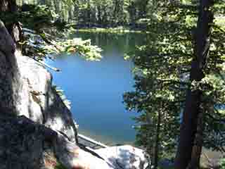
Up to Rubicon Lake A couple of wide switchbacks finally brings us high enough up to where the trail turns into a granite cut, still upholstered with dense forest, up into a channel scooped out by ancient glaciers to create this bit of terrain complexity to properly top-off our contemporary rock and forest mountainside. It is very nice. Very Hokusai-like, but this artist works in heavier materials. We are getting high enough the naked power of the granite is rising above the limits of its thinning terrestrial forest cover. Granite rising out of the Earth from under dense forest is now becoming Sky Granite. I like Sky Granite! Entering the nifty cut scooped out of the top and flank of the granite and forest mountainside terrain of the mountaintop we turn again. Pushing into the cut the trail soon turns us North over to Rubicon Lake sitting on its tiny flat shelf. I see Rubicon Lake as a tiny island of liquid peace wedged in the profound complexity of this sweet solid rock mountainside terrain. Water on the Rocks... is a nice feature of Desolation Wilderness.
Meeks Bay to Dicks Pass
Rubicon Lake's tiny size and unique location nestled on its tiny, cozy flat in between rock and forest high up high under Phipps Peak gives me a feeling of security. It is cozy in here at Rubicon Lake. That changes a few short feet South of Rubicon, where we begin to get expansive long views to the East-Southeast from atop precipitous cliffs. Just feet South of Rubicon Lake we also find the unmarked trail dropping Southeast down to Grouse Lakes, which is followed by a tough scrambling route down to the Eagle Falls Trailhead on Highway 89. See the Eagle Falls Trail Warning on the Next Page This is the first trail breaking off the TYT since the General Trail at Genevieve Lake. |
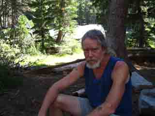
I need a break at Rubicon Lake
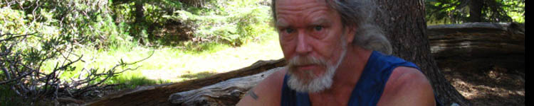
OUCH!
Snack & Rest break
at
Rubicon Lake
 |
 |
| Above: Rubicon Lake, Desolation Wilderness |
Above: Tired during the second day on the Tahoe to Yosemite Trail. |
 |
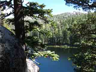 |
| View of Rubicon Lake Splitting Rock, Trees, and Water. | The views get better as we get higher passing the lake. |
Tired It was the second day of an unresupplied Tahoe to Yosemite backpacking trip, and carrying the monster weight of the heavy pack necessary to do this was kicking the bloody hell out of me. The good thing was that I expected it to do that, so I was not surprised or disappointed, just hurting as expected. The pain would go away as pack weight diminished over the days and weeks of the trip, but the memory of the experience stays fresh. The sharpness and depth of a memory is partially dependent on the physical and emotional intensity context of the experience. The mind and perspective of the observer comes into play next, but the real determiner of the nature of "experience," and how we form, store, and incorporate experience into memory and draw upon them for action are functions of the intensity of their creation. Mind and Memory were formed in the framework of, and for dealing with the Natural World that our contemporary backpacking experiences are bringing us back into, to various degrees. This explains my propensity for long distance High Sierra Backpacking. I seek full engagement for long periods of time. A Full Reset. We are, at the beginning and end, the conscious reflections of our environment. And a whole bunch of bullshit in-between.
A run through Nature cleans out the social bullshit and reawakens and resets our Natural Physical and Perceptive Tools in a healthy "Pain-Pleasure" balance. Well, it will be a healthy balance if we properly planned and prepped for our trip.
The Balanced Backpacker Achieving this natural context quite ironically beats the hell out of us at the same time it nourishes us and strengthens us. Nature is a series of Perfect Contradictions from Beginning to End. It is up to us to balance them, in our role as the conscious "reflector" of our environment. Thus I stress preparation and training.
Above, we can see that my pain-pleasure balance was a bit out of whack. Stress happens. |
|
Grouse Lake trail junction
just South of Rubicon Lake
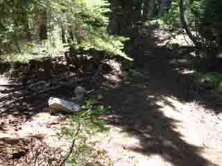 |
Unmarked The trail to Grouse Lake is blocked by big rocks to keep hikers on the TYT, so they do not accidentally wander off the main trail. You would be amazed at how many people just wander off the trails. |
Out to Eagle Falls This trail down to Grouse Lake was the old trail around Phipps Peak to the Pacific Crest Trail. Carefully observing the terrain we can see that this route also heads down the canyon through steep terrain towards Eagle Creek past Grouse Lake.
30 min map with Old Trail Route 30 min map with Old & New Trail Routes
DANGER There is no trail from Rubicon Lake to Grouse Lake to Eagle Falls on Highway 89 marked on any of the maps. The 1992 Rockbound Valley USGS Map shows a trail down to Grouse Lakes from above Rubicon Lake, then back up to the TYT a few steps to the North of Phipps Pass. There is no trail shown below Grouse Lakes.
Meeks Bay to Dicks Pass
The map contours indicates and our eyes have shown us some very steep and bushy terrain between the end of the level of the hanging canyon holding the Grouse Lakes and Eagle Creek below. I've never hiked this radical scrambling route down to Eagle Falls and its Trailhead, but I estimate it is 1.87 miles to Eagle Falls from this unmarked trail junction just a bit South of Rubicon Lake. But I may underestimate the distance. It is likely up to 2.25 miles in length. The reason for this variability is that the route will be defined by terrain and bush growth, which requires more or less deflections of our route, depending on growth and erosion. Approaching Phipps Pass hiking South on the TYT we can spot this trail dropping from Grouse Lake down towards Eagle Falls as our perspective of the terrain shifts while hiking South and climbing higher up near Phipps Pass. Check out the 30 minute map for an estimate of the route from observations. I've never hiked this section of scrambling route down to Eagle Falls via Grouse Lakes, but I would anticipate a challenging steep section getting down to Eagle Creek.
DANGER-DANGER If you have information about this route post it up on the |
Video
Beautiful Rock just above Rubicon Lake
| A nifty piece of rock. | ||
| Beautiful Desolation Wilderness Rock. |
North TYT: South Stony Ridge Lake South TYT: Phipps Pass
Desolation Wilderness |
||
A short break at Rubicon Lake refreshes the backpacker who is feeling the effects of altitude, climbing, and a very heavy backpack. That would be me. The look on my face reflects the experience of carrying a 75lb backpack up a Sierra Trail. Knee and shoulder issues required I take a considered approach to hiking. Pace, footing, balance, and posture must be perfectly matched to metabolism to achieve the most efficient and shock-free motion across the terrain. And it still pushes us hard, even with the most reasoned approach.. I will be physically and psychologically juggling the food vs weight vs mileage vs pain calculation for the next few days until my strength rises to the task, and the weight of my pack diminishes to a more manageable weight, and I adjust to the parameters of life on the trail. Nice campsites ring Rubicon Lake.
comments-questions-insights-information?
South |
Backpacking North Trail Guide |
 |
Backpacking South Trail Guide |
Backpacker ForumsGeneral thoughts on, or backpacking issues:Post it on
|
| High Sierra Backpacking Trails |
High Sierra Backpacking Topics |
Add your experiences, comments, or pictures
getting to, at or around Rubicon Lake:
Section
Tahoe to Echo Summit
Segment
Rubicon Lake
North TYT: South Stony Ridge South TYT: Phipps Pass
Trailhead
Contact
Alex Wierbinski

Backpacking Lake Tahoe to Mount Whitney
Your guide to the High Sierra Crest, including the Tahoe to Yosemite, Pacific Crest, and John Muir Trails
