The Trails
Guide
Maps
Miles/Ele
Permits
Resupply
Forum
Current Weather Conditions
Weather Notes
Northern High Sierras
Central High Sierras
Southern High Sierras
Gear
Gear List
Gettin Started
Layering
Discussion
Testing yourself and your gear
Gear Reviews
Hiking
The Pacific Crest Trail
from
Ebbetts Pass to Sonora Pass
Languages
Languages
Trail Arts
The art of walking
Physical Preperation
Trail Skills
The trail
Off the trail
Scrambling
Maps
Navigation
Camp skills
Food
Resupply
Food
Other
Photo Catagories
Trail Stories
Trail Culture
News and Science
Links
Groups
Books
Terms and Conditions of Use
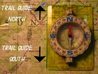
| Trail Guide INDEX Highway 4 to Highway 108 |
North PCT Ebbetts Pass to Raymond Peak |
South PCT Ebbetts Pass to Tyron Peak |
7.5 Topo Map SOUTH Ebbetts Pass to Tyron Peak |
This 30 min Map Ebbetts Pass to Sonora Pass |
Ebbetts to Sonora Pass MILES AND ELEVATIONS |
ALL TOPO MAPS EBBETTS TO SONORA |
Resupply North Lake Alpine South Kennedy Meadows |
National Forest PERMITS Toiyabe & Stanislaus |
all maps index |
Hiking
the
Carson-Iceberg Wilderness on the Pacific Crest Trail
Southbound Where we are Going with This Page What this Page Does Next I'll break in your boots and carry your pack... haha. Where this Page Goes The Long and Short of it
Ebbetts Pass to Sonora Pass Basic Backpacker Information A potential resupply point at the Lake Alpine Lodge sits 15 miles West down Highway 4. The Other Way Across That was not the case up in the Mokelumne Wilderness! Our next resupply point South is at Kennedy Meadows Pack Station sitting 9 miles West down Highway 108 from Sonora Pass. Kennedy Meadows Pack Station is located between the Southern boundary of the Carson Iceberg Wilderness and the Northern boundary of the Emigrant Wilderness. Duration of Ebbetts Pass
Northbound The Pacific Crest Trail hiker and others heading North out of Ebbetts Pass will be entering the Mokelumne Wilderness on our way North towards Carson Pass. Ebbetts Pass is 27.88 moderate miles South of Carson Pass on the PCT. There are no resupply resources at Carson Pass on Highway 88. More about your North and Southbound resupply options below.
|
IndexEbbetts Pass backpacker resources and information:
|
||||||||||||||||||||||||||||
VIDEO
Hiking into Ebbetts Pass from the South
| Hiking North to Ebbetts Pass | ||
Video: Ebbetts Pass. 1:17.
|
Ebbetts Pass
|
Ranger Districts, North and South along the Sierra Crest In the case of Ebbetts Pass this line along the Sierra Crest divides the Calavaras Ranger District of the Stanislaus National Forest sitting on the Western Flank of the Sierra Crest from the Carson Ranger District of the Toiyabe National Forest on the Eastern flank. Highway 4 also very roughly marks out the East-West line dividing the Pacific Crest Trail's route through the Mokelumne Wilderness to the North of Ebbetts Pass from the PCT's route through the Carson-Iceberg Wilderness to the South of the pass. But not exactly. Close, but not exactly. These National Forest Maps of the Mokelumne and Carson-Iceberg Wilderness show the wilderness precisely in relation to Highway 4 and lay out the routes of the Pacific Crest Trail North and South of Ebbetts Pass, respectively. Big Picture Carson Iceberg Wilderness Hiking Map The Eastern side of the Mokelumne Wilderness boundary to the North is sliced into shreds, while the Carson Iceberg Wilderness fattens up nicely to the South of Ebbetts Pass. |
The Permit Situation
The Carson Iceberg Wilderness
West Flank: Stanislaus National Forest East Flank: Toiyabe National Forest
Section Hikers and Big Loop Permits
Hiking South of Ebbetts Pass we are entering the Carson Iceberg Wilderness of the Toiyabe National Forest. Well, Kind of... the deal is that the National Forest Boundaries pass directly through the mountain passes. This is also true of Carson Pass to our North and Sonora Pass to our South.
If we are section hiking this part of the Pacific Crest Trail between Ebbetts Pass to Sonora Pass, or planning a big loop backpacking trip around the Carson Iceberg, we've got to get a permit. Ebbetts Pass, like the Carson and Sonora Passes North and and South, are uniquely situated.
Ebbetts Pass splits the National Forest boundary between the Toiyabe National Forest to the East with the Stanislaus National Forest to the West.
The route of the Pacific Crest Trail is designed to follow the Sierra Crest, and the Sierra Crest line itself defines the boundary between West and East Sierra flank National Forests. But in fact the route of the Pacific Crest Trail from Carson Pass South to our entrance into Yosemite National Park mostly stays on the Eastern flank of the Sierra Nevada.
The Toiyabe National Forest administers the East flank of the Sierra from the East flank of the Carson Range around the East shore of Lake Tahoe all the way down to, and around the East flank of Yosemite to Highway 120. The Toiyabe National Forest is HUGE, and our Pacific Crest Trail route remains almost exclusively in the Toiyabe from Carson Pass to our entrance into Yosemite National Park.
But the Toiyabe does not administer the North Sierra mountain pass trailheads.
The trailhead bulletin boards at the trans-Sierra mountain passes are maintained by the Western flank National Forests splitting the crestline boundary (El Dorado for the CPMA and the Stanislaus for both Ebbetts and Sonora Passes). But not to worry if you are driving in from the East: either the East or West flank National Forest will write us permits for the mountain pass trailheads if we walk into their Ranger Station on the way up to the trailhead through their National Forest.
I call the Calavaras Ranger District of the Stanislaus National Forest when I drive to Ebbetts Pass from the West, or I call the Carson Ranger District of the Toiyabe National Forest when I drive to Ebbetts Pass from the East.
West Flank: Stanislaus National Forest East Flank: Toiyabe National Forest
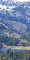
Resupply Ebbetts Pass in relation to our nearest resupply points North and South on the Pacific Crest Trail Ebbetts Pass Ebbetts Pass A potential resupply point at the Lake Alpine Lodge |
Ebbetts PassWhere We Are in relation to Services and Resupply For the Pacific Crest Trailer I've met very few Pacific Crest Trail hikers who resupply at Lake Alpine over the years. A few. The typical resupply pattern for the PCTer across the North Sierra is Tuolumne Meadows, Kennedy Meadows (75 miles North of Tuolumne Meadows), and then the Echo Chalet (70 miles North of KM). PCT section hikers are much more likely to take advantage of Lake Alpine's hospitality and services. Most PCTers bypass Ebbetts Pass as a resupply point. They are biting off 70+ miles of the trail between resupply points at a time, and for good reason. They are racing against the calendar to beat the late-season snows up North in the Cascades. And they have already crossed big distances hiking up to Muir Ranch as well as the Five Canyons North of Tuolumne. PCT hikers really begin to pick up speed and distance as the elevation and trail difficulty decreases North of Sonora Pass. But hitching down to Lake Alpine has its advantages. Lake Alpine and Bear Valley Lake Alpine Lodge will accept your resupply package sent through UPS and hold it for you at no charge. There are also showers, laundry, a poor backpacker's store, restaurant, bar, and bar menu at Lake Alpine. The restaurant is expensive, but a Pacific Crest Trail hiker could hitch the three extra miles down to Bear Valley instead of Lake Alpine and still do laundry, shower, eat a bunch of food at the deli, and then hitch back up to Ebbetts Pass to continue hiking the next day. I like to visit both places when I can. Nice folks at both. We basically have the same services at Lake Alpine as at the Bear Valley, but Bear Valley lacks the centrality of all the services as provided by the Lake Alpine Lodge, and has no shower or free resupply service. But the Bear Valley Deli is a heck of a lot cheaper than the Lake Alpine Lodge's fancy restaurant. But, Lake Alpine provides free backpacker resupply services, so I always treat myself to a breakfast and dinner there when I hike through, both for the great food and to pay them back for their long-time support for local and long distance backpackers. Nice folks. For the Tahoe to Whitney or Section Backpacker I've both bypassed and resupplied at Lake Alpine when backpacking the long trails between Lake Tahoe to Tuolumne Meadows, and on down to the Whitney Portal. Most times I stop at Lake Alpine for a day off or two. You can plan your trip to suit your tastes. But there's more to life on the trail than high mileage days. I have made a point of exploring the mountain outposts and communities that support backpackers, if I resupply or not. I've done this both to build this trail guide, and because I really enjoy spending a day sitting on the deck at the Lake Alpine Lodge having a beer while talking to their cool staff, the fishermen and campers from all around California who pass through there, and the tourists from all around the country and world who go there to see Highway 4's famous narrow track through the close-up beauties of the High Sierra. It's just relaxing fun with cool folks in a beautiful spot at the Lake Alpine Lodge. You're going to need a crowbar to pry my ass off of the Lodge's deck, because I almost always take a day off the trail at Lake Alpine. My thought is that I will spend the money on one of the Lake Alpine Lodge's expensive dinners because they go out of their way to take care of backpackers. It's the least I can do. If I have the money. If I'm running broke I head down to Bear Valley... Details-Details The Lake Alpine Lodge sits 15 miles West of Ebbetts Pass, and is where we could have sent ourselves a free resupply package via UPS, if that was in our plans. Bear Valley, which has a couple of outdoors-sports shops (socks, shoes, water bottles; they are ski shops in Winter, and mountain bike shops during Summer...) and an excellent store-deli, sits 3 miles to the West of Lake Alpine. The town of Arnold, where there are full grocery, medical, gear and repair services sits 42.4 miles West of Ebbetts Pass down Highway 4. It's an easy hitch-hike West to any of these destinations. I've met lots of good local folk hitching down to Lake Alpine, Bear Valley, and Arnold to explore local backpacker support during my hikes up and down the Sierra trails. You find some pretty cool people and things just off the trail. I can almost smell the massive bacon cheese burger swimming in a huge plate of fries at Suzie's Diner in Arnold from Ebbetts Pass... Tell Suzie and her uber-cool staff "Hey" from Alex if you stop in for a bite on the way into or back from Ebbetts Pass on Highway 4... East of Ebbetts Pass Markleeville and Gardnerville The Biker Bar was the turn-around point for the Markleeville Death Ride last I heard, and is always a destination for packs of Harley riders. Last I was there the ceiling of the bar was decorated with hundreds of bras contributed by biker babes over the years, but I heard that they took them down. Markleeville sits a mere 17 miles to our East from Ebbetts Pass. I've never resupplied in Markleeville, though I suppose you could. They have a tiny store, and if their Post Office is still open you might be able to send yourself a package... But you'd be a lot better off resupplying on the Western slope of the Sierra at Lake Alpine. Markleeville is five miles Left, North, up Highway 89 from the Highway 4 junction with Highway 89, which is located about 12 miles to the East of Ebbetts Pass. Highway 89 North is also the route to Gardnerville, while its Southbound end drops through Monitor Pass into the amazing little canyon down to Highway 395 crossing Antelope Valley a bit South of Lake Topaz and the California-Nevada boundary. There are great people up and down Antelope Valley, but little in the way of re supply resources. I've spent time during all four seasons in the fine little towns of Walker, Holbrook Junction, and Gardnerville resting from the last trip to begin the next. Country Folk are Refreshing If you plan on using Highway 4 at Ebbetts Pass as an opportunity to resupply, I strongly suggest sending a resupply package to Lake Alpine. |
|
Transportation
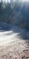
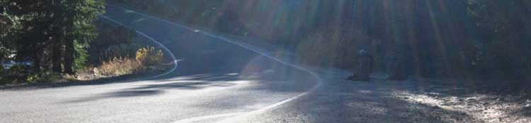
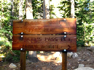
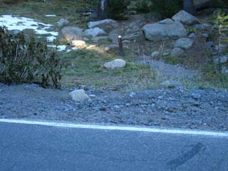
Hitching to and from Ebbetts Pass There is no public transportation across Highway 4. Either you drive or you hitch. During late Spring and early Fall the traffic on Highway 4 across Ebbetts Pass goes down to 3 cars an hour, by my count. I have found that one of every three cars will stop to say hello, and make sure that you are O.K. Nice people up there. During mid-Summer there is regular traffic across Ebbetts Pass. Up to 15 cars an hour. The real problem is getting to Ebbetts Pass from the West, across The Valley. The farmers and cowboys in The Valley rarely pick up hitch-hikers, and the idiot city yuppies driving across The Valley generally drive right past everyone, including backpackers. We've grown some pretty weird urban idiots/creeps is our mega-cities during the past half-century of unrestricted greed and growth. Try to hook-up with a Craig's List ride to get across The Valley if at all possible. Once you get across The Valley to Highways 49 and Highway 4 heading up-mountain you will easily get a ride. The country folk are still cool, and not afraid to meet and greet their fellow-citizens. If you are planning on starting a backpacking trip from Ebbetts Pass note that you cannot park at Ebbetts Pass. The sign below says, "Please do not park here."
The sign points towards the parking area located .03 of a mile East of Ebbetts Pass. |
Backpacker Assets & Resources Near and Far
North and South The long and the short of it... |
|
Mileage North 26.78 miles North 28.71 miles North to where the PCT and TYT rejoin in the Carson Gap, the entrance to the Lake Tahoe Basin. 38.78 total miles North to Echo Summit. We can hitch East on Highway 50 down to South Lake Tahoe from Echo Summit for some R&R. 40.78 miles North to Echo Lake Chalet, where we can pick up our resupply 57.99 miles North to PCT-TYT split at Velma Lakes, where the PCT continues North, and our Trail Guide follows the Tahoe to Yosemite Trail to where it begins at Meeks Bay... 69.49 miles Mileage Information |
Mileage South 29.44 miles South From Sonora Pass we have a 9 mile hitch West down to Kennedy Meadows, where we can pick up our resupply package. 48.57 miles South to where the PCT & TYT routes rejoin below Bond Pass in Jack Main Canyon 103.24 miles South to Tuolumne Meadows (Hwy 120), where we can pick up a resupply package miles South to Reds Meadow and Mammoth Lakes, where we can pick up a resupply package.
Mileage information Carson-Iceberg Mileages Stanislaus NF Miles Map |
Campsites North |
Campsites South
|
Backpacking Topo Maps North and South Planning Maps To plan your trips North or South from Ebbetts Pass you should refer to the free downloadable USGS topo map series. The 1 x 2, 30 minute, and 7.5 series topo maps are free to download and open in the free Adobe Reader. You can also download the free Terrgo Toolbar for Adobe, which gives you limited trail measurement capabilities. Here's the USGS Store site. It will provide the proper maps to plan this part of your trip. Navigate the map to Stockton Ca, and follow Highway 4 up to Ebbetts Pass. Check the "mark points" selection, click the desired quadrangles and select the map sizes you want to download, and download them. Unzip the file and open it with Adobe. I have set myself up with a well-organized collection of USGS maps covering all my main routes and side trips from Lake Tahoe to Mount Whitney in various scales. I find these maps very helpful to properly plan trips. Use these detailed USGS topo maps, and the maps, mileages, and trail guide pages laid out here on Tahoe to Whitney to plan the details of your backpacking trips starting at, or hiking across Ebbetts Pass. Hiking Maps For trail use I prefer to carry the USDA National Forest Wilderness Maps when hiking either the Mokelumne or Carson-Iceberg Wilderness. These maps are a fine balance between size and detail. Each well covers its respective wilderness area. The new 2009 plastic maps are better in field conditions, but the color, labeling, and accuracy of the new maps leaves a lot to be desired compared to the older 1988 paper map. One step forward, two steps backwards... Familiarity gained with the detailed USGS maps during your planning stage will make better sense of your trail maps during your trip. Trail Maps North: USDA Forest Service Mokelumne Wilderness, ENFIA. South: USDA Forest Service Carson-Iceberg Wilderness, Toiyabe National Forest. Though long-distance hikers may consider these topo hiking maps too "big," the extra coverage provided by these "whole wilderness" topo maps allow the backpacker to clearly and correctly identify terrain features within their range of vision. I always want to know what I'm looking at, and how my route fits into the "big picture" of the overall terrain. Unlike topo hiking maps that only display a "sliver" of the terrain, these wilderness-sized topo maps allow you to situate and saturate yourself in the terrain. Good Long-Distance Backpacker Practice I send myself my selected hiking topo map for the upcoming trail section in my resupply package. As most of the resupply points have mail services I mail my last map back to myself from the re supply point when I finish that section. |
Ebbetts Pass Backpacker Tour and Information
| Ebbetts Pass Tour | ||
| Video: Ebbetts Pass Tour. 3:00 |
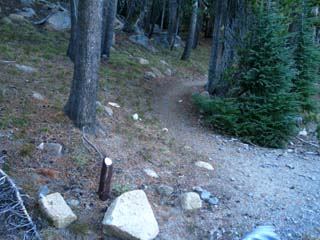
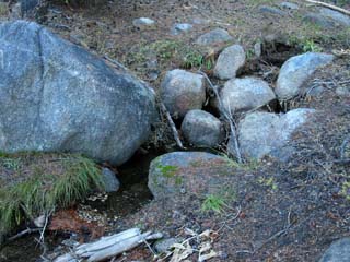
Pacific Crest Trail North and all-season Creek at Ebbetts Pass
| Pacific Crest Trail on the North side of Ebbetts Pass. | A small creek runs across Ebbetts Pass. | |||||
 |
 |
|||||
| Another trail by the sign joins the PCT. | It usually runs through October. |
Pacific Crest Trail South from Ebbetts Pass
| Pacific Crest Trail on the North side of Ebbetts Pass. | ||
 |
||
| The trail up from the parking lot meets the PCT .36 of a mile South. |
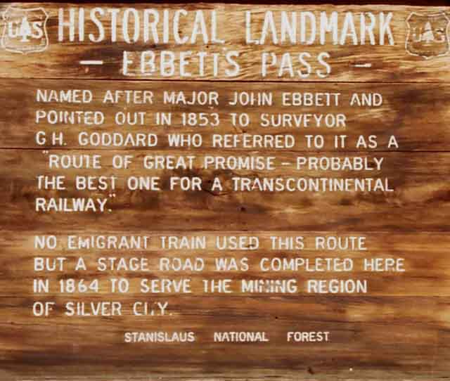
| Ebbetts Pass Historical Marker | ||
 |
||
Ebbetts Pass Ebbetts Pass is a part of the tides of Western History which first washed over the mountains from the East during the early 1840s. Though the Spanish colonized the coast in 1776, the same year the American Colonies on the other coast decolonized themselves, the Spanish did not penetrate far into the interior off their costal redoubts. The breakaway of Mexico from Spanish control by 1820 left the Spaniards on the Coast of California feeling obedient neither to Mexico City nor Madrid. It was during these years after 1820 when the grip of the Spanish Church and State slide off California that Americans first ventured Westward to California. I have an essay up that traces the early Spanish history of California through the Gold and Silver Rushes you may find interesting. During 1848 the wealth of the Gold Rush, the proximity of the rising power of America, and the social belief in Manifest Destiny almost assured that the wealth and resources of California, let alone the territory between California and Saint Louis, would be absorbed into the United States. An excellent reprise of the first early explorations of the Sierra Nevada by Americans is contained in the preface of this PDF of the History of the Toiyabe National Forest. |
Sierra History Recent names of topographic features represent the character of our Western interaction with the terrain. The Old These folks had names for all their local terrain features. The folks from the East met the folks from the West and traded their respective assets with each other at meadows along the Sierra Passes. These old names are broadly forgotten, as far as I know. Maybe not. There are extensive tribal folk up and down the Highway 395 corridor, but I've never had the chance to ask about ancient naming. Recent naming is a lot easier. Hit up the comments or History Forum if you have information on naming, or just to share some High Sierra history. The New These mountains were overrun first by gold prospectors during the early 1850s, and then by seekers of silver in the late 1850s through the 1860s. Settlers Disasters Contemporary View Changing Time Changing Naming Still Fun |
Ebbetts Pass History Ebbetts Pass Ebbetts Pass National Scenic Byway Ebbetts Pass Ebbetts Pass History Tahoe to Whitney Historical Resources High Sierra Historical Monuments
History Forum Intro-Info
|
Southbound Hiker's
NOTES:
Short and Medium Distance Hikes in the Carson Iceberg Wilderness
This Section From Ebbetts Pass we have a 29.44 mile hike on the Pacific Crest Trail South to Sonora Pass on Highway 108. From there we will easily hitch 9 miles West to access our next resupply package at the Kennedy Meadows Pack Station. I'm looking forward to that already... Kennedy Meadows has an excellent restaurant that serves three squares a day, a store, a bar, laundry facilities, and excellent showers. Best of all I like the people who work there, and the family who owns the operation. But your trip South into the Carson Iceberg Wilderness doesn't have to go all the way down to Kennedy Meadows from Ebbetts to Sonora Pass. There's all sorts of excellent short, medium, and long distance hikes we can carve out of the Carson Iceberg Wilderness from Ebbetts Pass. Explore the Carson Iceberg Wilderness Not Only Section Hiking I've laid out a trip report about a Carson-Iceberg loop you might find interesting. This loop was planned as a 79 mile loop around the Carson-Iceberg Wilderness weaving together elements of the Tahoe to Yosemite and Pacific Crest Trails around the Carson-Iceberg. It finally ended up as a shorter 4 night 51 mile loop, but it was a gas nonetheless. Loop Trips using PCT and TYT It gets better. As we head South these two classic trails are connected by four trails along their routes from Highway 4 to Highway 108. This means that we can craft a huge range of short to medium distance backpacking loops around the Carson-Iceberg incorporating sections of the Pacific Crest Trail in one direction, then crossing over to the Tahoe to Yosemite for the return leg. Or visa-versa... Check out our potential routes on this map: Carson Iceberg Wilderness The Highland, Arnot, Disaster, and the Boulder Creek trails are the trails that connect the Pacific Crest Trail to the Tahoe to Yosemite Trail. Starting at Ebbetts Pass on the PCT (or at any of the four PCT-TYT trailheads around the Carson Iceberg Wilderness) we can hike down the PCT to any of these trails to connect with the TYT to hike down to Lake Alpine or loop back to Ebbetts Pass for a hike who's length is determined by which connector trails we choose. The Carson-Iceberg is completely awesome. It contains classic sections of both the Pacific Crest and Tahoe to Yosemite Trails which can be hiked in short bits or woven together into substantial backpacking trips remaining within the Carson-Iceberg Wilderness, pushing North to Lake Tahoe, or South to Tuolumne Meadows. The Carson-Iceberg Wilderness offers a remarkable range of experiences for all levels of backpackers, from short trips for the checked-out novice to isolated cross-country routes perfect for the grizzled old expert backpacker. As we head South on this trail guide I will point out the Murray and Golden Canyon trails down to the East Carson River, and take a look at some of our potential Eastern entries into the Carson Iceberg Wilderness. The Carson-Iceberg Wilderness? It's real good. |
Echo Lake Chalet South Lake Tahoe Two Full Service Cities on the Trail Though re supply is distant from Ebbetts Pass to the North and to the South, good camping is available near the pass. Nice campsites sit just North of Ebbetts Pass at Sherrold and Upper Kinney Lakes. Ebbetts Pass itself has a small stream flowing through. If you arrive late you will have water. Terrain North Administratively, heading North from Ebbetts Pass on the Pacific Crest Trail we will cross in and out of the Toiyabe managed Eastern section of the Mokelumne Wilderness many times as we repeatedly cross its highly convoluted boundary with Toiyabe National Forest lands. This means that we will encounter a series of 4-wheel roads and 4-wheel campsites if we look around the territory from Raymond Peak to Forestdale Divide. |
| Ebbetts Pass in relation to resupply and the Tahoe to Yosemite Trail at Lake Alpine. | ||
The Pacific Crest Trail at Ebbetts Pass is 15 miles East of the TYT at Lake Alpine. |
The Locals are Active!Local News |
North: Ebbetts Pass to Raymond Peak South: Ebbetts Pass to Tyron Peak
Ebbetts Pass for the Long-Distance Backpacker |
||||||
Ebbetts Pass Backpacker East and West The difference between accessing Gardnerville to the East or Arnold to the West from Ebbetts Pass to obtain full services are as significant as their climatic differences. Both Gardnerville and Arnold have full-service medical services and big grocery stores. First, Gardnerville is outside of the Sierra. The Eastern flank of the Sierra ends abruptly, terminating in a series of valleys wedged between the Sierra on the West and the mountain ranges to the East. The Pine Nut Range East of the Carson Range across Carson Valley to the North, the Wellington Hills to the East of our position across Antelope Valley, and the Sweetwater Mountains to our South across the West West Walker River. The Long Western Flank of the Sierra Nevada Mountains The Valley is the Sierra The Sheer Eastern Escarpment of the Sierra Nevada Mountains Highway 395 bounds the Eastern limit of the Sierra for its entire length. Interestingly, just as the soils of The Valley on the Western side of the Sierra are deposited erosion off the Western Sierra, so too are the valleys along the Eastern escarpment of the Sierra are also composed of material eroded from the Sierra. The depth of the deposited material are thousands of feet in some locations. The actual base of Mount Whitney is buried under thousands of feet of eroded Sierra debris, far below Lone Pine. Eastern Climate This majesty is complemented by the deep silences that come with the remoteness of the terrain to major population centers. Though it's a short distance to the crest from the Eastern base of the Sierra, the Eastern base of the Sierra is itself a remote place. Though beautiful and deserving of launching many excellent backpacking trips into the Eastern High Sierra, these towns on Highway 395 along the base of the Eastern Sierra are not our best resupply options from Ebbetts Pass. Highway 4 It always takes longer to drive these roads than we anticipated. Relax and enjoy the view. Get yourself up to the trailhead a day early to camp and acclimate before beginning your backpacking trip. For more information about Highway 4 itself, check out Let's review our position at Ebbetts Pass
top of page |
Backpacking Trail Guide PCT |
 |
Backpacking Trail Guide PCT |
Backpacker ForumsHave a great Sierra Nevada trip or story to relate? A fine piece of gear? Or gear that failed?Post it on
|
North: Raymond Peak to Ebbetts Pass South: Ebbetts Pass to Tyron Peak
Trailhead
Contact
Alex Wierbinski

Backpacking Lake Tahoe to Mount Whitney:
Your Guide to the High Sierra Crest, including the Tahoe to Yosemite, Pacific Crest, and John Muir Trails
