|
2014
2016
2015 High Sierra
Backpacking Calendar
January Februrary March April May June July August September October November December
The Calendary of Record
This calendar is designed for the four-season backpacker. This calendar anticipates important dates in the Sierra Nevada, from the beginning of Winter expectaions of fierce storms, deep snowpacks, through the Spring Thaw to fine Summer conditions.
We look for the dates and the conditions that determine the density of our Winter Gear, and when it can be thinned to the gear of Spring, to when we can finally pull out the Summer Gear. This point has been getting earlier for decades. Winter has radically shortened.
This changes the dates when our trails and resupply spots open up, and when we can begin our long treks down the Sierra Crestline. It affects when we plan, pack, and send our resupply packages.
These changes up the odds for PCT hikers to finish in one long season, but also up the odds for backpackers to get "caught-out" by unexpected storms.
Thus these calendars will track the difference between "classic" Sierra seasonal conditions and the current conditions on the ground over as many years as I can watch the fun.
We will warn of the power of of Winter, while taking note of both its failures and surpises, and notes how this affects the openings and closing dates of the resupply spots.
2014 Calendar 2016 Calendar
If you have any interesting information or dates of note that should be on the calendar, let me know, and if they are pertinent to backpackers I will post them up.
Hiker1@TahoetoWhitney.com |
Last Year
January 2015
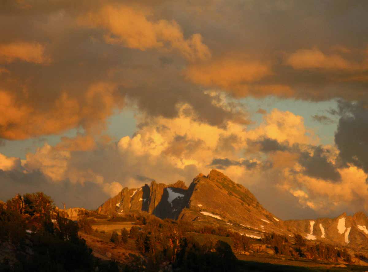
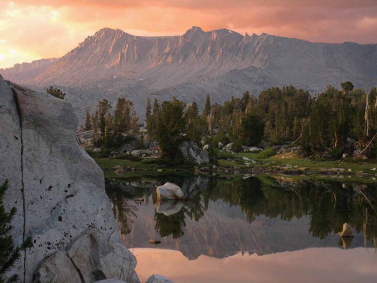
North Desolation Wilderness
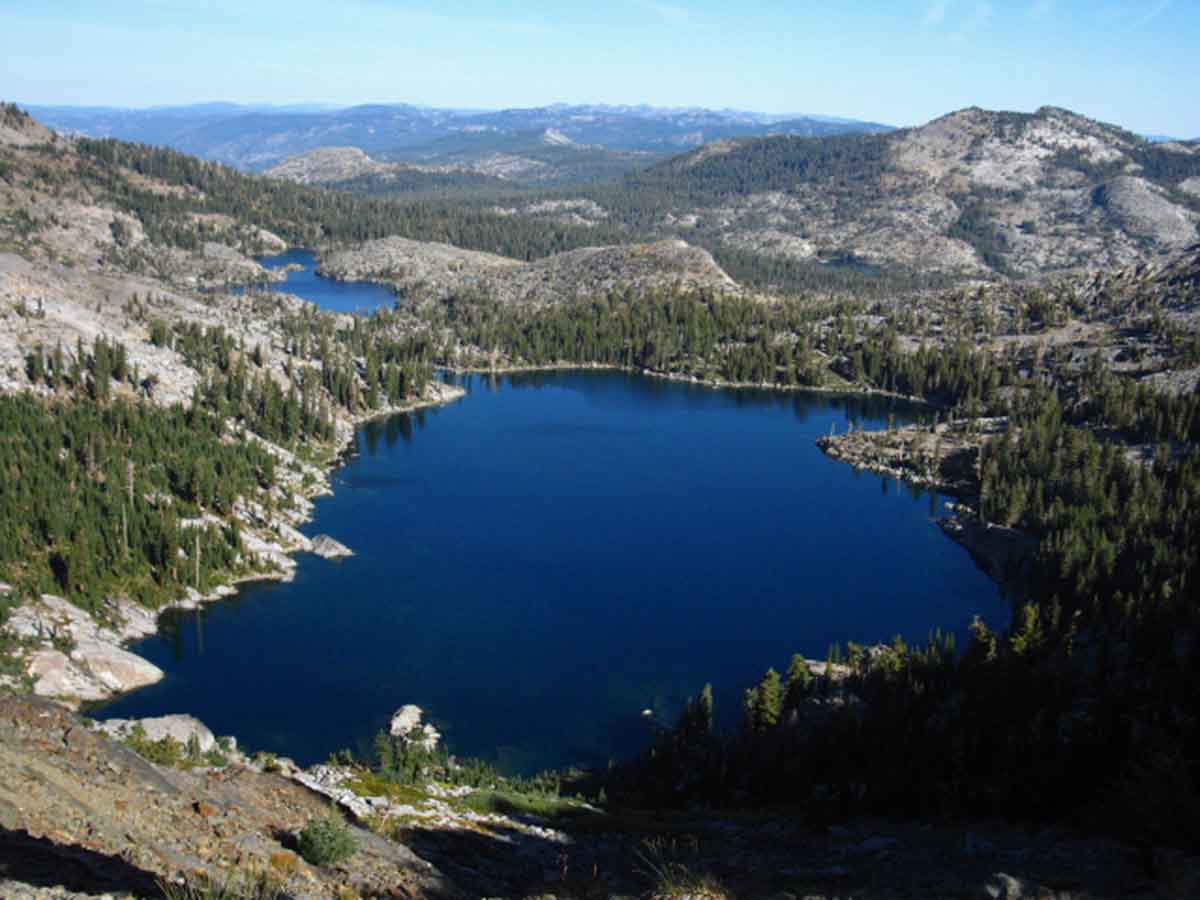 View North across Dicks and Fontanillis Lakes. Phipps Peak and Pass are the prominent peak in the middle-Right background. Note Middle Velma Lake nestled in below Phipps Peak. Our route from Meeks Bay on the West Shore of Lake Tahoe crossed Phipps Peak to join the Pacific Crest Trail in the Desolation Wilderness just a bit North of Middle Velma Lake.
Trail Guide Map Miles and Elevations
January 2015
| Sunday |
Monday |
Tuesday |
Wednesday |
Thursday |
Friday |
Saturday |
FULL WINTER CONDITIONS
The Fall Gear has been stowed or complimented by the heavy Gear of Winter.
Weather
Reserved permits for June 2015 now available from Yosemite NP and Desolation Wilderness.
All Permits
Yosemite Permits Desolation Wilderness |
30 |
31
|
1
Permits
Permits for JUNE 18 2015 available from Yosemite TODAY.
New Year's Day
Yosemite Permits
Desolation Wilderness
Hoover Wilderness |
2
Backpackers
Full Winter Gear and precautions
REQUIRED
|
3 |
4
|
5 |
6 |
7 |
8 |
9 |
10 |
11
|
12 |
13 |
14
SNOW CAMPERS
Track snow, storms, and temps to determine character of Winter. |
15 |
16 |
17 |
18
|
19
M L King Day |
20 |
21 |
22 |
23 |
24 |
25
|
26 |
27 |
28 |
29 |
30 |
31 |
NOTE
2015’s weather is forming up for an early start for both the Spring and Summer Hiking Seasons. This can change. 2014 was one of the earliest openings of the high trails I remember. The year before was one of the latest. Extremes have become the new normal.
At this point I put the chances of any Southern Storms blowing up to relieve our drought at less than 1 in 3. The Northern Storm Gate has been blocked most of 2013 and 2014, and the heat blocking it has not brought tropical moisture to replace the lost Northern Storms. Time will tell, but my money is on continuing cold and dry conditions bringing an early opening of High Sierra Trails.
NOTE
JANUARY 2015 ASSESMENT
January set the record for all of human recorded history in California by having virtually no rain. None.
2014 Calendar 2016 Calendar |
Permits
Yosemite National Park and Desolation Wilderness accept reservations six months in advance for Summer backpacking dates.
June 2015 reservations are available in January, July in February, and so on.
Yosemite Permits
Desolation Wilderness
Hoover Wilderness
|
The cold and snows of January provide both excellent backpacking experiences and establish the terms, a baseline for this year’s transition into Spring Conditions.
Deep snows, regular storm activity, and cold temps indicate a long Winter into Spring transition. Not this year, so far.
Light snows and irregular storms may indicate a quick and early transition into Spring conditions.
Tahoe to Whitney
Top of Page |
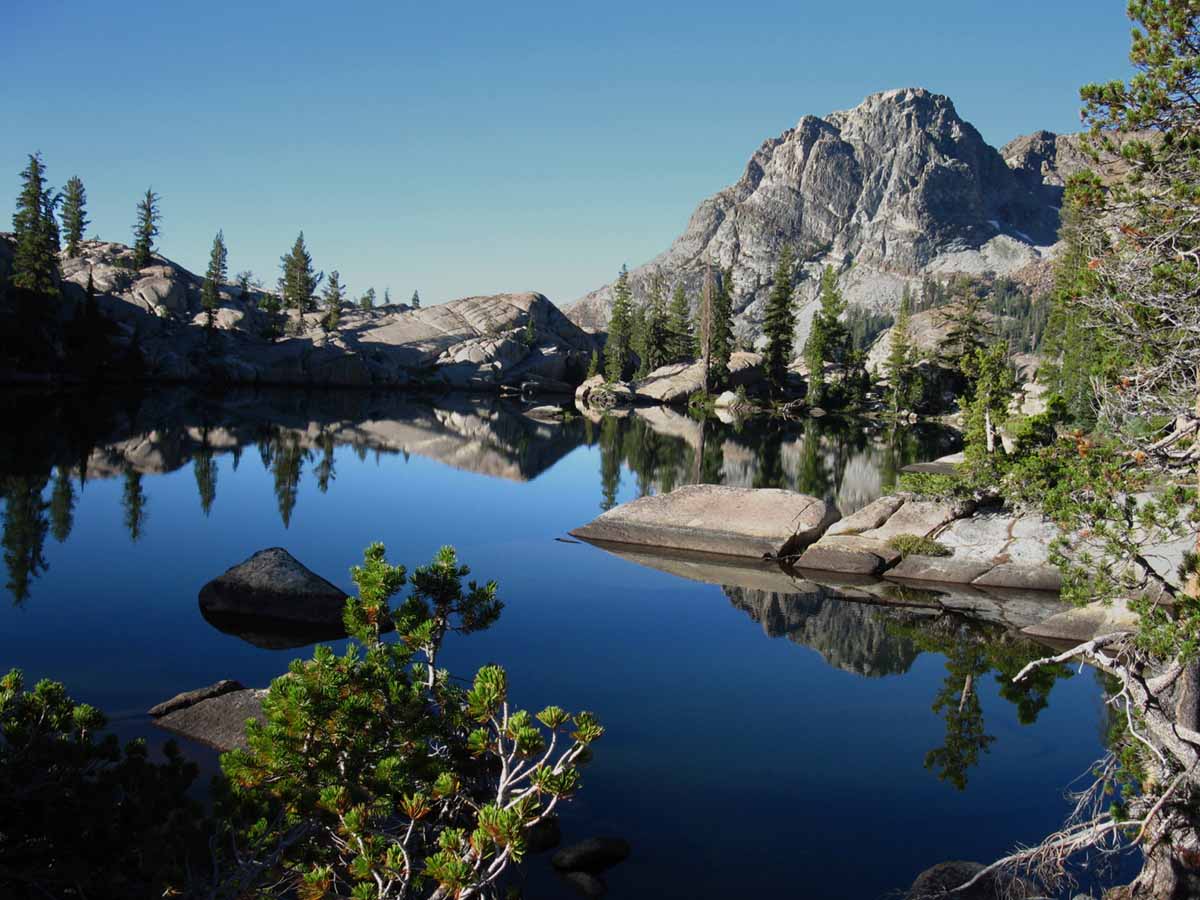
February 2015
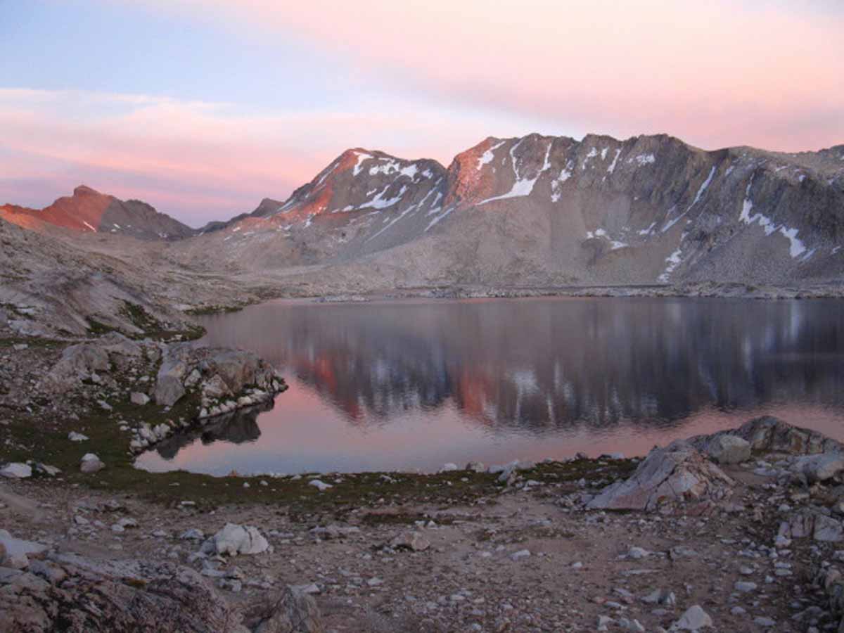
Summit City Canyon
January Februrary March April May June July August September October November December
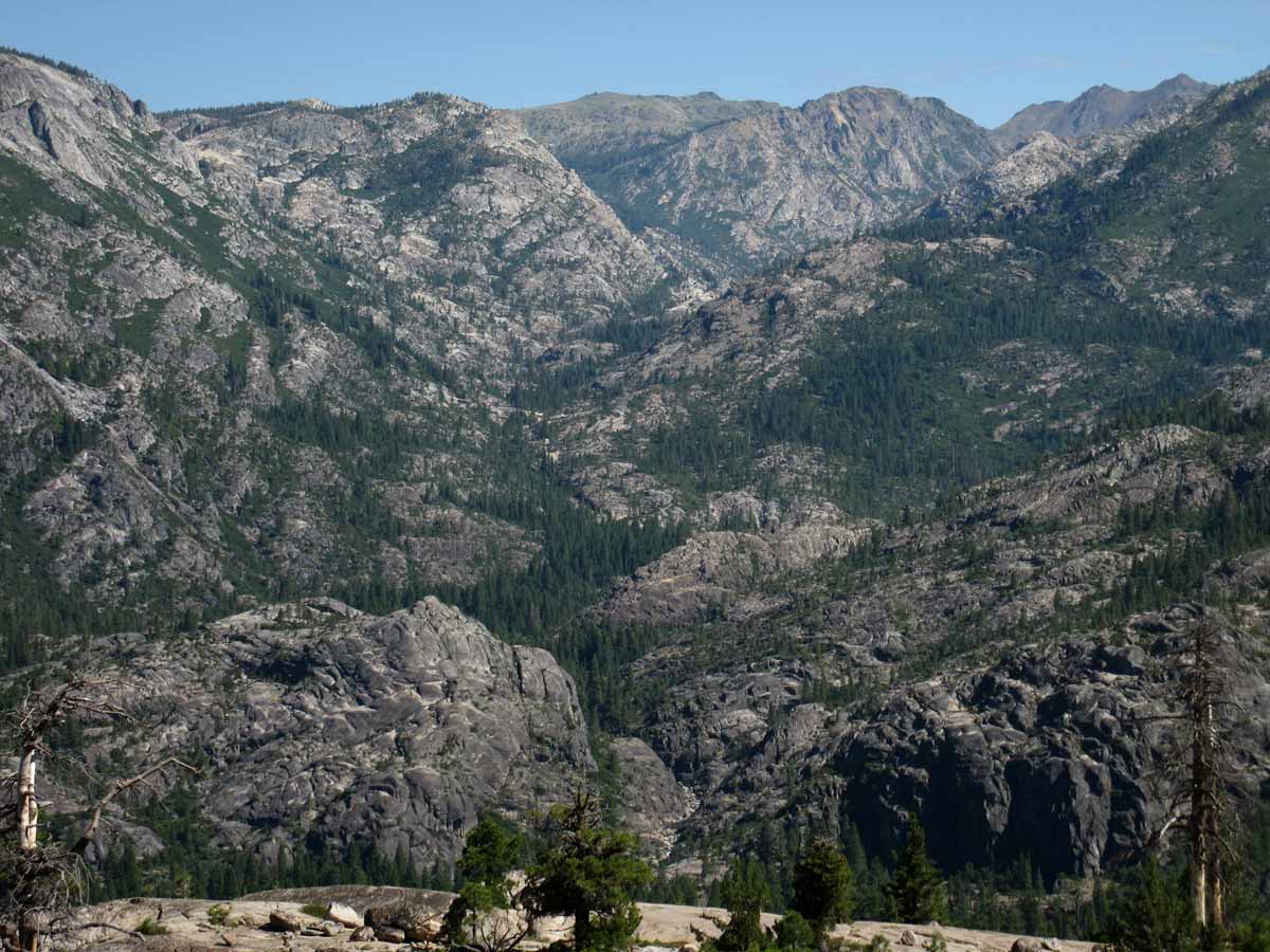 The full length of the Tahoe to Yosemite Trail route through Summit City Canyon in the Mokelumne Wilderness. Note The Sisters in the upper Right hand corner, and Horse Canyon in the upper-middle of the image. At the middle-bottom we can see the North Mokelumne river passing through its narrow gorge just above where it runs past Camp Irene, where we began this climb up the NW flank of Mount Reba. That is the narrow section where the catastrophic Spring Thaw of 1997 pushed up a massive log jam, causing massive destruction in the surging pool of timber behind it, and which swept away all in its path when it broke.
Labeled Image
Trail Guide Map Miles and Elevations
February 2015
| Sunday |
Monday |
Tuesday |
Wednesday |
Thursday |
Friday |
Saturday |
PRECAUTIONS AND OPPERTUNITY
Backpackers are observing patterns and trajectory of Winter storms and temps to find Hiking Windows into the
Winter Wonderland.
UPDATE
Well, not this year. With virtually no rain in the first half of the month an little prediced for the end.
|
27 |
28 |
29 |
30 |
31 |
| 1
|
2 |
3 |
4 |
5
Winter Gear
Be geared for sub-freezing and sub-zero temps with wind chill
High Sierra Reporting Stations
|
6 |
7 |
8
|
9 |
10 |
11 |
12 |
13
|
14
Valentine's Day |
15
CCC
Backcountry Trail Crew
Applications due
|
16
Presidents' Day |
17 |
18 |
19 |
20 |
21 |
22
|
23 |
24 |
25 |
26 |
27 |
28 |
NOTES: Short days and long cold nights are the bookends within which we plan our trips.
High Sierra hiking trips can be followed up with exciting trips into the moderate Winter Climate of Death Valley.
UPDATE
2015 Report
Bizarre weather pattern holds. Storm Gate from the NW is not even possible, as the jet stream across the N Pacific has "flipped" South. Rather than bringing weather down from Alaska, the jet stream is now blowing North out of the Central Pacific.
2014 Calendar 2016 Calendar
|
Are Weather Conditions
Moderating?
Accelerating?
March can be Great for Snow Backpacking.
UPDATE
Not this year. No snow.
FEBRUARY 2015 ASSESMENT
NO SNOW |
Piercing Cold this month or just “Normal Cold?
(Answer: Hot and Dry. Record low snowfall, snowpack, rain, with record high temperatures. )
Heavy Snow Storms or None at All?
(Answer: Virtually none at all. Dry Jan and one little storm in Februrary.)
UPDATE
Our Observations of how this series of Unusual Seasons works out determines our Range of Hiking Possibilities and the Gear Necessary to Explore them.
All signs indicate a very early opening of the Sierra Nevada this year.
Tahoe to Whitney
Top of Page |
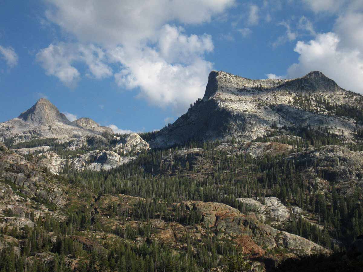
March 2015
The Tahoe to Yosemite Tral across Emigrant Wilderness
January Februrary March April May June July August September October November December
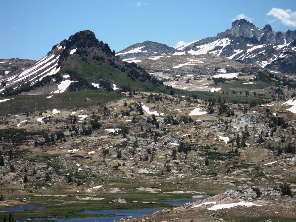 View across the High Emigrant Meadow with Emigrant Meadow Lake of Emigrant Wilderness below, Grizzly Peak in the middle distance, and Tower Peak in the distance. Note the three ridges between Grizzly Peak and Tower Peak. Crossing the second ridge brings us through Bond Pass into the top of Yosemite's Jack Main Canyon, where we will rejoin the Pacific Crest Trail. Tower Peak sits at the head of Tilden Canyon, which is the last variant of the TYT from the PCT route on our way South across the North Yosemite Backcountry to Tuolumne Meadows.
Trail Guide Map Miles and Elevations
March 2015
| Sunday |
Monday |
Tuesday |
Wednesday |
Thursday |
Friday |
Saturday |
OBSERVE
The Winter and its Snowpack.
HEAVY? LIGHT?
Character and Sources of Storms?
Are Spring Conditions arriving with Spring?
Snowpack Status Sierra Reporting Stations
UPDATE
Sever Drought Conditions Persist!
|
24
|
25 |
26 |
27 |
28
|
1
Summer Hiking
Plans
Permits
In agreement with the progress of Spring? |
2 |
3 |
4 |
5 |
6 |
7 |
8
START
DAYLIGHT SAVINGS TIME
Add one hour at 2 am.
GMT - 7 hours
(Ends Nov. 1)
Astronomical Information
Navigation Information |
9 |
10 |
11 |
12 |
13 |
14
Tahoe to Whitney
&
PCT--JMT hikers
Order food, prep resupply packages, and repair gear.
Resupply
|
15
|
16
|
17
The Big Green One
Saint Pat's Day |
18
UPDATE
Virtually No Rain,
hot temperatures,
little snow in the Sierra.
Carson Pass
measures 22 inches.
Tuolumne Meadows
.20 of an inch |
19
UPDATE
The Drought
is
On!
|
20
First Day of Spring
The Vernal Equinox |
21 |
22
|
23 |
24 |
25
Carson Pass
21 inches of snow
42 degrees at 11am
Ebbetts Pass
13 inches of snow
43 degrees at 11am
|
26 |
27 |
28 |
29
|
30 |
31 |
|
|
|
|
NOTES: Are heavy storms rolling in? From the North or South? Is a pattern forming?
UPDATE
Nope. Things are shaping up to be the hottest, driest year on record, topping off a multi-year series of increasing heat and drought records.
This will translate into the earliest opening of the High Sierra for Summertime backpackers in history if these conditions persist.
The Week of March 16
The press just picked up the drought story after a NASA scientist writes California has "One year of water left."
It is about time...
Their lame coverage shows no indication that the press understands that our policies of irresponsible growth and greed have brought us to disaster. Nope, their concern is with just how to keep this feeding frenzy of greed going... until we run all the way out of water and the forests burn.
High Sierra Weather |
|
THE QUESTION
Have temps risen enough to start shifting into lighter Spring Gear from our heavy Winter Gear?
Correct Layering is Vital.
MARCH 2015 ASSESMENT
Very little snow, Very high temperatures.
Extreme Drought Conditions
2014 Calendar 2016 Calendar |
The nature of our Snow Backpacking trips are determined by the character of the snow.
Deep, soft, wet snow makes for rough going, as does fresh powder.
Cold hard well-packed snow can be faster than good trail.
Tahoe to Whitney
Top of Page |
April 2015
Tropical Thunderstorm climbs the East Sierra
January Februrary March April May June July August September October November December
A beautiful and powerful cell of tropical weather out of the Sea of Cortez slams the steep East Sierra flank with heavy lightening and downpours. The storm sucked up red, yellow and golden colors of the sands it crossed from the intervening deserts between our high mountain position in the Emigrant Wilderness and warm tropical seas far to our South.
Trail Guide Map Miles and Elevations
April 2015
| Sunday |
Monday |
Tuesday |
Wednesday |
Thursday |
Friday |
Saturday |
Spring Conditions?
It Depends.
Conditions on the ground, NOT a date on the calendar determines our gear and skills requirements.
Snowpack Status Sierra Reporting Stations
Trans-Sierra Highway Information
Summer's Coming!
Resupply Information
|
31
|
1
JB declares Water Emergency
25% State-Wide cutback.
Carson Pass Hwy 88
11 inch Snow Depth
Tuolumne Meadows
1.3 inch Snow Depth
Deadman Creek Hwy 108
9 inch Snow Depth |
2 |
3
M & P Early Season Yosemite backpacking trip, Glacier Peak Road. |
4 |
5
Easter
STORMLETS
A set of Weak "Stormlets"
cross North Sierra |
6
Snowpack
Carson Pass
8 inch Snow Depth
Tuolumne Meadows
.3 inch Snow Depth |
7
Carson Pass
19 inch Snow Depth
Tuolumne Meadows
6.5 inch Snow Depth |
8
KM to Open last weekend
of this month.
Carson Pass
15 inch Snow Depth
Tuolumne Meadows
5.6 inch Snow Depth | 9 |
10 |
11 |
12
|
13 |
14
Backpacking
Plans?
Are our hiking plans and conditions on the ground in agreement?
Earliest trail Opening in High Sierra History developing this year.
Or will a vast storm blow in?
Tahoe to Whitney Plan |
15
Hot Day |
16
Interesting...
Hot Day
Snow with no Storm
The South end of a rotating
high pressure zone to
our North is
pulling
humid air Westward-Offshore Flow!
This has
brought light snow
from the EAST to
the
Sierra Nevada Mountains. |
17 TRANS-SIERRA HIGHWAYS
Hot Day
Ebbetts Pass Opened
Sonora Pass Opened |
18
Hot Day |
19
Snotel Station Reports
Pre-Storm Snow Depth
Carson Pass 2 inches
Road Open
Ebbetts Pass 0 inches
Road Open
Sonora Pass 2 inches
Road Open |
20 WEATHER UPDATE
First Storm Activity since
April 5 approaches North California Coastline.
Weak Low far to Northwest will/may drag 2 weak fronts across
the
North Sierra.
RAIN or SNOW?
SNOWTEL
Tuolumne Meadows .8 inch |
21 |
22
ADZPCTKO.org
TWO EVENTS
April 22-24
April 24-26
Annual PCT kickoff event. |
23
|
24
2014
KM Opening
Small Storm passes
over North Sierra.
Lucky the storm passed at night, or it would have rained across the Sierra Crest.
|
25
Snotel Station Reports Post Storm Snow Depth
Carson Pass 3 inches
Ebbetts Pass 11 inches
Sonora Pass 10 inches
Tuolumne Meadows 6.1
|
26
|
27 |
28 |
29 (UPDATE April 8)
Bloom & Weather announce:
Kennedy Meadows Pack Station,
Highway 108,
OPENS |
30
Super Hot Day |
|
|
Conditions Vs. Plans
Is there a huge snowpack?
(This Year: Almost NO SNOWPACK)
Have you Late Spring or Early Summer Hiking Plans?
Current conditions will tell you if your early season hiking plans are possible.
APRIL 8 STATUS
8% of Average Snowpack
High Sierra Backpacker Weather
|
NOTES:
Critical Water Shortage deepens with an almost complete lack of Winter precipitation across the lowlands nor snow across the Sierra Nevada.
Early season set of tiny "stormlets" April 6-8 bring no real relief, and do not establish a new trend of wetter weather. High building in after storms.
Though conditions beckon backpackers out, any precipitation falling on the Sierra Crest will still fall as snow. Great caution must be exercised by early season backpackers. |
It is TIME
Consult with Resupply Location Information to assure resupply buckets are mailed in a timely fashion.
Some will go early, some will be mailed later...
APRIL 2015 ASSESMENT
Earliest Trans-Sierra Highway Openings on Record?
High Sierra Backpacker Resupply
2014 Calendar 2016 Calendar |
RESUPPLY TIPS
Always use plastic buckets to ship your resupply:
Any container a mouse can chew through or water can penetrate is at risk.
Think about what you'd like, as well as what you need in your resupply bucket.
A bottle of wine or whiskey is a nice thing on a cold Sierra night at the resupply.
Tahoe to Whitney
Top of Page |
May 2015
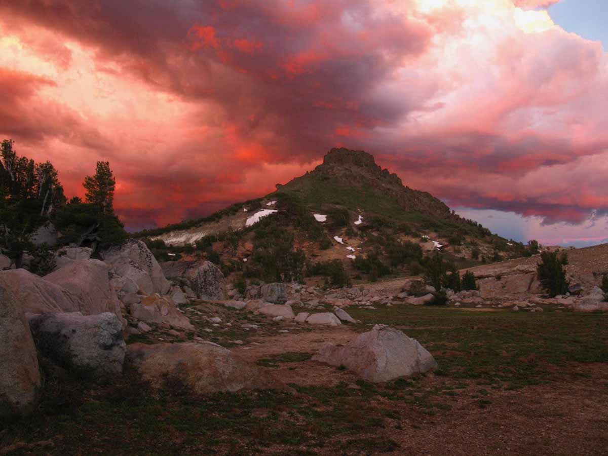
Forsyth Peak
January Februrary March April May June July August September October November December
A glimpse at Forsyth Peak in the very Northwest corner of Yosemite National Park under the soft but fierce pastel clouds of a thunderstorm dying as sunset approaches.
Trail Guide Map Miles and Elevations
May 2015
| Sunday |
Monday |
Tuesday |
Wednesday |
Thursday |
Friday |
Saturday |
Last Spring Snow Trips?
Once the Spring Thaw gets going the rivers and creeks will rage, making fording very dangerous.
Not likely this year. There is little to no snow on the Sierra Crest to surge through the watersheds.
Anticipate very early openings of the resupply facilities along the Sierra Crest. Mid to late May.
Watch the weather, of course, but this looks like a record early opening of the Sierra. Again.
|
28
Scouting Trips Page
When will the PCT-TYT, High Altitude Sierra Trails open in 2015?
|
29 |
30 A
Super Hot Day
WHAT’S UP??
Heavy Spring Snow pushes Summer back,
No Snow brings Summer Conditions early.
High Sierra Weather
THIS YEAR:
Earliest Spring-Summer transition in
RECORDED HISTORY.
|
1
Snotel Station Reports Snow Depth
Carson Pass 0 inches
Ebbetts Pass 0 inches
Sonora Pass 0 inches
Tuolumne Meadows 0 inches |
2 |
3
|
4
Spring Gear
Lighter than Winter, Heavier than Summer Gear. Maybe Now?
|
5 |
6
SPRING INSTABILITY BEGINS
The weather makes a turn for the worse after an incredible warm and dry period.
No powerful storms, but constant clouds, rain and light snow falling for the next (21) days to the 27th... |
7
WEATHER ALERT !!
Weak Low Pressure Zone
moving West across Sierra, and South.
1.08 inches of precipitation forecast for next 7 days.
Rain and Snow mix likely.
Could wash what little snow on the Sierra off it. |
8
National Weather Service
Quantitative Precipitation Forecasts:
RAIN FORECASTS
High Sierra Weather |
9
Snotel Station Reports Snow Depth
MESOWEST stations
Carson Pass 0 inches
Ebbetts Pass 5 inches
Sonora Pass 7 inches
Tuolumne Meadows .3 inches |
10
Unsettled Weather
in
Sierra Nevada
Mother's Day |
11
Snotel Station Reports Snow Depth
MESOWEST stations
Carson Pass 0 inches
Ebbetts Pass 0 inches
Sonora Pass 0 inches
Tuolumne Meadows .80 inches |
12
Tahoe to Whitney
issues
EL NINO
BACKPACKER ALERT |
13
WEATHER ALERT !!
Disorganized Low Pressure Zones
Two inches of precipation anticipated in NW Sierra thru Saturday evening.
Quantitative Precipitation Forecasts:
RAIN FORECASTS |
14
Permits
Make Sure we have our long distance Summer permit plans worked out.
Desolation, Hoover, and Yosemite all begin accepting reservations 6 months in advance.
That would be in January... |
15
Vermilion Valley Resort
Reported first JMT hiker
on
May 14
Anticipated Opening
Date
Early!
(Open) |
16
Sierra Cloudy, raining, sleet, snow. |
17
Sierra continues to be wrapped in deep clouds spitting light rain and snow.
T-Storms too!
Temps barely at freezing overnight.
|
18
Add to or learn from the
When will the
PCT-TYT,
High Altitude,
Sierra Trails,
open in 2015?
page on the Trails Forum. |
19
Ebbetts and Sonora Passes
Closing for weak
Snow Storm
Carson Pass 0 inches
Ebbetts Pass 0 inches
Sonora Pass 0 inches |
20
Bloom reported PCT hikers hiking down closed Hwy 108 for resupply on the 19th. |
21
Peter at
Lake of the Sky Outfitters in
South Lake Tahoe
Reports arrival of first three of this year's PCT hikers. |
22
Days of muggy clouds, rain and very light snow continue.
7 day precip forecast calling for up to an inch of rain in Sierra over next week.
Quantitative Precipitation
Forecast
|
23
Texas Pounded by
weeks of
Record Thunder Storms, Tornadoes, and massive floods.
Central and North Central Texas is basically underwater. |
24
|
25
Memorial Day
Echo Lake Chalet
and
Lake Alpine Lodge
OPEN
Depending on Weather
|
26
Nighttime Temperatures
Staying above Freezing:
The inflection point for the traditional "Thaw" has arrived. |
27
First Clear Day
over Sierra Nevada since May 6. |
28 |
29
|
30
Sno-Park Permits
End of permit restrictions for use of Sno-Park parking lots.
|
| 31 |
|
|
|
|
|
|
NOTES:
The High Sierra resupply spots are all opening up this month or early the next, a good sign that we should have our trip plans and logistics down and done by now.
We have planned-out every overnight campsite we will sleep at and every individual calorie we will consume by now, meaning that we are about ready to finalize our buckets, seal them up, and determine the exact timing of their shipment to best match our anticipated arrival date.
Earliest Opening of Roads and Trails in History?
2014 Calendar 2016 Calendar
May 2015 Tracking the Drought page
May 2015 Tracking the Sierra Conditions page.
|
May gives us a good indication of the unfolding trajectory of Spring.
MAY 2015 ASSESMENT
Extreme Drought Conditions unmitigated by Winter.
Thin snows on the Sierra Crest and light Storm Activity indicates an early opening of the High Trails across Mountain Passes.
High Sierra Backpacker Weather |
May marks the center-point of openings of our High Sierra Resupply facilities
Kennedy Meadows Pack Station opened last month.
The Tuolumne Meadows Post Office, Reds Meadow Pack Station, VVR, and Muir will all open next month
Tahoe to Whitney
Top of Page |
June 2015
Magical pond on the South end of Seavy Pass
January Februrary March April May June July August September October November December
 Seavy Pass is the high point in a wide bowl filled with beautiful ponds atop the ridge separating Bensen Lake from Kerrick Canyon along the combined TYT-PCT routes through the North Yosemite Backcountry. Above we are passing around the Southernmost pond before beginning the great descent to Bensen Lake.
Trail Guide Map Miles and Elevations
June 2015
| Sunday |
Monday |
Tuesday |
Wednesday |
Thursday |
Friday |
Saturday |
31 |
1
VVR Opens
Depending on Weather
High Sierra Weather |
2 |
3 |
4 |
5
KENNEDY MEADOWS
PACK STATION
ADULT HORSEPACKER
CAMP
BEGINS |
6
TS BLANCA
Moving N to tip of Baja California. |
7
|
8
TS BLANCA
Storm breaking up on landfall at N end of Sea of Cortez.
Great amount of tropical mositure dissappated across Southwest |
9
BLANCA REMNANTS
Push North, and spun West into Sierra. |
10
T-storms and Rain from
TS BLANCA
Raining on the Sierra Crest
1.1 inches of rain predicted over Sierra next 7 days. |
11
RAIN FORCAST REVISED:
.5 inches of rain predicted over Sierra next 7 days.
High Sierra Weather
Rain Forecast |
12
KENNEDY MEADOWS
PACK STATION
ADULT HORSEPACKER
CAMP
ENDS
RAIN REVISE TO 0 |
13 |
14 Father's Day
Reds Meadow
Accepts resupply packages
KENNEDY MEADOWS
PACK STATION
KIDS HORSEPACKER
CAMP
I
BEGINS |
15 |
16
HEAT WAVE BUILDING
High Temps along
Sierra Crest
Snow retreating to highest South Sierra Peaks & Crestline.
None on the North Sierra
for WEEKS.
The LAST BITS of the
Sierra Snowpack |
17 |
18 Ramadan Begins
KENNEDY MEADOWS
PACK STATION
KIDS HORSEPACKER
CAMP
I
ENDS |
19
KENNEDY MEADOWS
PACK STATION
KIDS HORSEPACKER
CAMP
II
BEGINS
Tuolumne Meadows Post Office reports busiest times ever. |
20
Clear and Warm |
21
Summer
Solstice
North Sierra SNOW FREE
South Sierra rapidly losing thin pack along crestline.
Snowpack, June 21, 2015
First Day
of
Summer |
22 |
23
Muir Ranch
Begins offering resupply package pickup
|
24
Big High Pressure building in across whole North-Central, Northeast, Central, and Northeast Pacific Ocean.
This looks like the end of the Spring Instability and advent of full-blown Summer HEAT.
ENSO inputs seem to be going IR batshit... |
25
KENNEDY MEADOWS
PACK STATION
KIDS HORSEPACKER
CAMP
II
ENDS |
26
Heat Wave Building in,
Thunderstorm Mechanism is operating, enhanced by trough bringing moisture-rich air North.
Valley temps up to 103 this next week. These temps can drive fierce T-Storms. |
27
|
28
|
29 |
30 |
|
|
|
|
NOTES: The Snowpack on the Sierra, storm activity, and temps during June are going to allow us to get a bead on when the Sierra Trails across the High Passes will start opening up, as well as the trails approaching them.
High Sierra Backpacker Weather
When the snows melt millions of mosquitoes rise from the saturated soils. It starts low down the mountain early in Spring and rises up the mountainside as Spring progresses. Be ready for the rising clouds of mosquitoes.
High Sierra MOSQUITOES
MARCH 2015 OBSERVATION REGARDING SPRING-EARLY SUMMER:
Everybody will open early, unless prohibited by use agreements. The issue driving behavior in June is going to be fires, not snowpack. This year is shaping up to have the hottest Wintertime temperatures pushing earliest opening of the Sierra trails and resorts with the least amount of snow and rain recored since the Western settlement of California.
JUNE 2015
A very warm unsettled month of May has brought continued unsettled Weather conditions into June. The overnight temps have been above freezing since late May, and the tropical remnants of Blanca appear to be scouring the remaining snow off the South Sierra quite quickly on June 10.
I expect a regular groove to be cut by hikers through what snow remains in the South Sierra mountain Passes along the JMT by the start of June.
2014 Calendar 2016 Calendar
|
Permits
Only remnants of reserved permits are available out of Yosemite, Mount Whitney Zone, and Desolation Wilderness.
Through-hiker permits into or across these areas are still available.
Permits
June 24 Report
ENSO activity seems to be tormenting the central-East US with tropical moisture appearing as tornadoes and T-storms. The "gunsight" that points this energy our way is not seasonally adjusted to point at the Sierra, but it looks like the "clip" is full.
This means that as Fall cooling beings these tropical flows could be pointed our way, if ocean heating trends continue.
Or not. We could just as easily maintain drought conditions. I put the chances at tropical El Nino Fall rains at 50-50 from today's perspective. |
JUNE 2015 ASSESMENT
Tropical Thunderstorms, Rain and Snowstorms from supercharged El Nino torment lightly-geared PCT Hikers.
The real danger of June is found between the swollen banks of rivers and even normally small placid creeks, surging with the power of the Spring Thaw. (Not this year)
During heavy Spring Thaws one can hear the grinding of unseen great granite boulders as supercharged river flows easily roll them downstream. (Not this year)
Carefully assess all river crossings, have contingency plans for being knocked down and losing your pack, and turn around if the dangers are too great. (All Years)
Tahoe to Whitney
Top of Page |
July 2015
Volunteer and Double Peaks
January Februrary March April May June July August September October November December
Descending towards Bensen Lake we observe the massive climb following our descent when we continue South from Bensen. This is one of the hardest sections of the whole Tahoe to Whitney hike.
North Yosemite Backcountry
Trail Guide Map Miles and Elevations
July 2015
| Sunday |
Monday |
Tuesday |
Wednesday |
Thursday |
Friday |
Saturday |
Backpackers
Shift to Summer Gear well under way. Be ready for last bursts of Spring Weather.
Ignore the Calendar.
Gear up for the Conditions on the Ground, not a Date on the Calendar.
High Sierra Backpacker Weather
ON THE TRAIL
This year July is seeing a tremendous amount of Tropical Storm Activity across the Sierra Crest. These conditions are bringing severe Lightening, Downpours, heavy Hail, and even a great burst of heavy snow.
July 2015
Current chances of experiencing
SEVERE WEATHER are INCREASED.
|
30
Vast Tropical Flows
Pushing North into Valley and across Sierra from massive tropical activity in the E-Central Pacific:
NWS 1 KM SAT
FIVE DAY PRECIP: 1.9 in TROPICAL RAIN, T-STORMS
|
1
Tuolumne Meadows
Post Office
OPEN
Depending on Weather
(OPENED MID JUNE !!)
High Sierra Weather |
2
OFFSHORE BREEZE OF
TROPICAL MOISTURE!
South and Southwestern
Winds |
3
|
4
All Parks, Forests, Wilderness, Campgrounds and Trails are
BUSY
Independence Day
Permits |
5
|
6 |
7 |
8
Serious Tropical Flows
drawn North by local low pressure zone moving East across Sierra bringing days of fierce Thunderstorms, Lightening, and Torrential Rains. |
9
Tropical Storms
Reno Floods. |
10
Storms Abating |
11
Clear Weather
George & Sue
Married
CONGRATULATIONS!
Ceremony at Burst Rock in Emigrant Wilderness, followed by a backpacking honeymoon into the Emigrant Backcountry.
And Tahoe afterwards... |
12
Clear Weather
|
13 |
14 MOSQUITOES
Mosquitoes rise when the snows melt.
Mosquitoes are typically THICK.
This year: Skeeterts are thin. Early for thin...
|
15 |
16
Remnants of Baja Ca Hurricaine drawn North into LA, South Deserts, and bringing more tropical storms to Sierra Nevada.
LA Floods
Hwy 10 Closed by Flash Flood |
17
Ramadan Ends |
18
Scattered Tropical Remnants bringing irregular T-storms, rain, and hail.
It has been a "Tropical Summer," so far. This trend began in mid-May. |
19
|
20 |
21
Humidity Declines |
22
National Weather Service
7 Day Precip Forecast
Five Day Precip Forecast:
.5 total in North Sierra.
Seven Days:
.5 total |
23
NWS Forecast:
Clearing Trend
Five Day Precip Total to 0.
Sixth-Seventh Days: .16
|
24
NWS Forecast:
Clearing and Heating Trend.
|
25 |
26
|
27
Heat Wave, Dry.
Tropical humidity and rain predicted from Thursday. |
28 |
29
7 Day Rain
7 day precip total put at 1.7 in. along Sierra Crest
These predictions are highly variable, and change as the week progresses.
Torrential in Florida... |
30
Rocky Fire Fact Sheet (June 29) |
31
Rough Fire |
|
Standard JULY NOTES:
I’ve seen years when the snowpack sticks through the Summer, and years where the snowpack clears by mid-June. The past four decades the average annual snowpack has radically declined and the date the snow clears has gotten earlier and earlier.
Independent of the long term trends our trip planning and gear selection are guided by careful observations of the character of each season’s weather. This year is no different.
This Year:
Freak Tropical Weather blowing North bringing unsettled weather into the Sierra since late May, and certainly persisiting through now, mid-July. The El Nino conditions in the East-Central Pacific are already epic by July 22, which is very early in the timing of a typical El Nino "season."
This indicates a high probability of our already tropically-unsettled weather being supercharged by a heavy El Nino building into Fall. We will see. This tropical weather has served to suppress what would have been a disastrous fire season, and has served to put the drought on "suspended animation," somewhat retarding its progress.
Last two times I saw El Ninos like this (over last 40+ years) California suffered epic Fall flooding. Epic.
|
|
DANGERS
Monitor weather for afternoon Thunderstorms
Beware of dangerous fording conditions
Mosquito conditions are typically going Hog Wild during this time of year.
Not during 2015!
Mosquito Populations are still being depressed by the drought conditions, despite the Spring and Summer tropical rains.
2014 Calendar 2016 Calendar |
July brings the peak of the Summer Thunderstorm Season in the High Sierra. These are local weather, caused by heat waves in the San Joaquin Valley swept up the West Sierra Flank.
Hot wet air on a fast ride up the West Sierra flank to high elevations squeezes out what can be substantial daily rain and lightening activity lasting between 2 pm and sunset.
Don’t cross open ground under one of these storms. They are deadly. Lightening and Fording are the leading causes of High Sierra backpacker deaths.
2015 Update
This year's constant series of thunderstorms are tropically born, not local. These thunderstorms are the product of distant moisture-rich tropical air being driven North by air currents generated by the intense tropical thunderstorm activity that generated them in the first place. These moisture rich airs are then sucked across the Sierra by an abberent series of stubborn unstable low pressure zones over California and the West Coast of the U.S.
Tahoe to Whitney
Top of Page |
August 2015
View down Tuolumne River from Glen Aulin High Sierra Camp
January Februrary March April May June July August September October November December
View down the Tuolumne River while hiking across the footbridge just South of Glen Aulin High Sierra Camp at morning sunlight lighting up the canyon.
Trail Guide Map Miles and Elevations
August 2015
| Sunday |
Monday |
Tuesday |
Wednesday |
Thursday |
Friday |
Saturday |
Prime Time Backpacking
Mosquitoes diminishing to irrelevance.
Hot Temps moderate into cool backpacking.
Lowering Sun brings increasing contrasts to terrain.
Hiker Traffic Decreasing.
MONTH OF FIRE
Rough Fire Continues
|
28
|
29 |
30 |
31 |
1 |
2
|
3 |
4 |
5 |
6 |
7 |
8 |
9
|
10 |
11 |
12
Rocky Fire incident update |
13 |
14 |
15
Mosquitoes
Mosquitoes die as terrain dries.
August 15 is the drop-dead date during “normal” Years
|
16 |
17
Cold Evenings
August evenings are getting colder and colder.
Begin adding layers as Fall conditions emerge.
|
18 |
19 |
20 |
21 |
22 |
23
|
24 |
25 |
26 |
27 |
28 |
29 |
| 30 |
31 |
|
|
|
|
Rocky Fire
Jerusalem Fire |
|
Typical Year : Wet years extends the mosquitoes’ reign past the 15th, Dry years shorten it.
Wet basins and lakes that hold water on vast sheets of solid granite below their green-grass coverings feed the mosquitoes later into the season than terrain that drains.
Thus we will find “holdout zones” where local mosquito populations remain high long after the surrounding terrain has dried out. My advice when you encounter one of these zones: RUN!
THIS YEAR: Drought. Weird tropical weather through July. August to typical conditions, but under extreme drought context. Thus August began running up into one of the worse fire seasons ever. September's weather will decide. Massive El Nino Conditions are boiling the Central Pacific. Somebody is going to get flooded.
|
Stay Alert
Though August is wonderful, it also potentially puts us into range of early-season storms and temp plunges.
It’s getting time to start supplementing our Summer gear with bits of our thicker Fall Gear.
2014 Calendar 2016 Calendar |
The diminishing heat of Summer days are intermixing with the deepening chill of cold nights warning of approaching Fall conditions.
The Summer “high season” is now over, and trail traffic diminishes. The PCT hikers are long gone, and the JMT hikers are down to a trickle by the end of August.
The normal unpredictability of Sierra temp changes and storms are increasing, and so too should our gear selection start thickening up with bits of extra Fall insulation, to match the rising potential of cold conditions as the seasons change.
2015
The threats are fire and tropical weather.
The enduring trend of shortening Winters and the subsequent diminishment of Rain and Snowpack during the last 25 years has evolved into a completely different weather pattern. The storms out of the Northwest, in fact the whole North Pacific Weather Pattern has been disrupted. I would say it has been shattered.
The various unhinged elements of our old pattern have not re-established a new pattern, but two things are clear. First, our traditional pattern of Winter storms out of the Northwest has been shattered. It will likely re-occur every 3 to 7 years on a diminishing cycle, but it is done as the dominant feature of Winter weather on the whole Northwest Coast of the US.
Second, the temperatures and humidity have risen to levels un-natural for the North Lattitudes.
The establishment of this new weather pattern is now re-ordering the type and distribution of plant and animal life rapidly, through fire.
New plants, animals, and trees will replace those burned.
For backpackers this means that the rising threats into this year's September are massive fires and unexpected tropical downpours. |
Tahoe to Whitney
Top of Page |
September 2015
Stunning colors of sunset in the John Muir Wilderness
Looking Northeast from near Island Pass at Blacktop Peak and its massive massif.
January Februrary March April May June July August September October November December
Massif under Blacktop Peak from unnamed lake in Island Pass. Donohue Pass and Peak are to the Left out of the image.
Trail Guide Map Miles and Elevations: Not yet online
September 2015
| Sunday |
Monday |
Tuesday |
Wednesday |
Thursday |
Friday |
Saturday |
EL NINO BOILING THE CENTRAL NORTH PACIFIC
FIRES BURNING ACROSS CALIFORNIA.
For backpackers these conditions require awareness of potential Fire and Tropical Downpours.
Fire and Smoke Information
El Nino Report
Huge Fires Burning: Rough Fire Continues
|
1 |
2 |
3 |
4 |
5
|
6
|
7
Echo Chalet Closes
Labor Day |
8 |
9
Butte Fire |
10 |
11 |
12
Valley Fire |
13
Muir Ranch
Resupply Service stops accepting resupply buckets
Call Muir for Exact Date
|
14
|
15
Tuolumne
Meadows
Store, Café, Post Office
Approaching closing date.
|
16 |
17 |
18 |
19 |
20
|
21 |
22 |
23
First day of Fall
Cooler Temps!
Shorter Days!
Note Weather Changes.
Thicker Gear for Fall
GEAR |
24 |
25 |
26
|
27
Galactic
Boo-Day
Happy Boo Day!
|
28 |
29
|
30
Muir Ranch
Last day to pickup resupply buckets.
Call Muir for Exact Date |
|
The Season is Tapering Down
Labor Day marks the beginning of the end of the Summer Backpacking Season in the High Sierra.
Resupply Facilities begin closing up for the Season.
Danger
The potential for low temps is increased. Early season storm possibilities rise significantly.
Carefully begin monitoring weather conditions while
considering Fall additions to Insulation and Gear.
2014 Calendar 2016 Calendar
|
Typical Year: The chances of early season cold and even an unexpected snow storm require we gear-up for the expected and the unexpected.
Each month is getting colder, bringing rising potential for some serious unexpected early snow as each day passes. Though hiking the Fall conditons of August, September and October offer some of the most spectacular views and beautiful experiences the High Sierra Nevada Mountain Range offers, we're also under expanding threat and increasing potential for a wide range of Winter weather conditions. We've got to keep an eye on the sky, as always. But especially during Fall.
This Year: High temperatures and a boiling El Nino make snow seem like an unlikely memory and impossible future. Cauldrons of hot water from the West Coast of Mexico down to the South of Peru and reaching West across the Central Pacific have created a center of fierce tropical storm production in the Central-East Pacific generating lines of hurricanes it is pushing East-Northeast across the Central Pacific.
A persistant trough over California has been sucking vast unconsolidated chunks of this tropical moisture North in the early days of September. Here's what I see:
El Nino storms will miss California if the weird tropical high that has been setting up over the North Pacific during the drought Winters reestablishes itself and persists. This High will transport El Nino moisture around California and the High Sierra. This High is forming up as strongly in mid-September as are El Nino conditions. That makes sense, as it's the same un-natural heat in water and sky driving both.
We may see a historic flow of tropical moisture into California and the High Sierra If the Winter High Pressure Zone does not set up over the North Pacific, and North Pacific Surface heating and Arctic "weakness" (Another warm Winter Arctic) perpetuates the breakdown of the North Pacific Jet Stream.
Warming Arctic Winters are feeding the growing pattern of Winter storms coming out of the tropics from the West and Southwest. In the case of a warm Arctic Winter without building a Winter High over the North Pacific could transport potentially historically unparalleled storm activity moving vast amounts of tropical moisture across California and the High Sierra.
In other words, we could get slammed or shut down.
In either case these conditions are unique in the span of human history. Enjoy the ride.
|
September brings the full palet of Fall beauty and cold conditions to the High Sierra.
From the golden grasses around diminished lakes to the great sweeps of bright yellow aspens cutting through the uniform evergreen canopy, beauty is bursting forth even as life slows into its Winter sleep.
The weight of the bear-proof can be left behind, but the pack gets heavier as the necessity of thicker gear demands we carry greater weight.
Well, not yet. But we are now watching carefully for the signs of Fall and the approach of Winter.
2015
BACKPACKER ALERT
The threats are fire and tropical weather.
The enduring trend of shortening Winters and the subsequent significant diminishment of Rain and Snowpack during the last 25 years has evolved into a completely different weather pattern. The storms out of the Northwest, in fact the whole North Pacific Weather Pattern has been disrupted. I would say it has been shattered.
The various unhinged elements of our old pattern have not re-established a new pattern (they are still changing!), but two facts are crystal clear. First, our traditional pattern of Winter storms out of the Northwest has been shattered. It will likely re-occur every 3 to 7 years on a diminishing cycle. Winters dominated by storms out of the Northwest is done as the dominant feature driving Winter weather on the whole Northwest Coast of the US.
(I see two factors driving the Degradation of the North Pacific Winter Weather Pattern:
Factor A> The significant warming of the Arctic Circle during Winter has diminshed the polar region's ability to draw West Pacific storms up to the perimeter of its once powerful spinning vortex of brutal cold, to "power them up," and toss them across the West Coast of the US.
Factor B> The warmth of the North Pacific ocean surface and atmosphere during Winter in N Lattitudes has deflected the path of the typical North Pacific Winter Jet Stream across the Northeast Pacific, leaving the West Coast of the US dry.
The combined effects of the warming Arctic Circle and North Pacific Jet Stream changes are also responsible for the great "slides" South of Cold Arctic air masses over the Mid-West and East Coast over the last few Winters, causing those "polar vortexes."
Typical Winter storm patterns are not being drawn up to the Arctic Circle, they are not being fired up by the spinning vortex of the North Polar Region during Winter, nor are the resulting super-charged storms riding the Jet Stream down to California. That's the pattern that's over, the old pattern that drove fertility in California and the High Sierra.)
Second, the temperatures and humidity have risen to levels un-natural for the North Lattitudes. We appear to be moving towards a tropical "Wet and Dry"-season type of pattern at 38 N. We'll see. We've loosened the forces of chaos, now we will see what happens, and where they end up.
The establishment of new basic meterological conditions in the North Pacific and Arctic Ocean assures that this new weather pattern has just now begun to re-order the type and distribution of plant and animal life rapidly under its changed footprint, forcing all to adjust to the new reality. Here in California that will be through fire for the trees, and lack of water for the animals and humans.
New plants, animals, and trees more suited to the hotter, drier climate will replace those burned, until they too are supplanted.
For backpackers this means that the rising threats into this year's September are massive fires and unexpected tropical downpours. |
Tahoe to Whitney
Top of Page |
October 2015
Black Giant rises in pinks of setting sun beyond Muir Pass with Wanda Lake in the foreground
January Februrary March April May June July August September October November December
The Black Giant backdrops Muir Pass from our campsite on a rise above Lake Wanda.
Trail Guide Map Miles and Elevations: Not yet online
October 2015
| Sunday |
Monday |
Tuesday |
Wednesday |
Thursday |
Friday |
Saturday |
Danger
Every couple of years late season backpackers are surprised by an Early-Season Snowstorm.
Two feet of unexpected snow strands backpackers.
ARE WE READY for the UNEXPECTED?
|
29
|
30 |
1
Reds Meadow
Stops
accepting Resupply Packages
Tuolumne Meadows
Facilities closed for sure!
|
2
Deploy Fall Gear
GEAR
With the elements of Winter gear to survive unexpected events |
3 |
4
|
5 |
6 |
7 |
8 |
9 |
10 |
11
|
12 |
13 |
14
Kennedy Meadows Pack Station
Highway 108,
Closes Today 2015
|
15
VVR Closes
Depending on Weather |
16
2015
FALL TEMP DROP
Freezing Overnight Temperatures in North-central and Northwestern United States. |
17 |
18
|
19 |
20 |
21 |
22 |
23 |
24 |
25
|
26 |
27 |
28 |
29 |
30
|
31
2015
BACKPACKER ALERT
2015
First Winter Storm Warning, First Storm
Halloween |
NOTES: Cold conditions are a reality, even without unexpected snow and storms. Nighttime temps are cold and can PLUNGE.
I describe the factors controlling the outcome of the great planatary forces at play: An El Nino beyond all historical conceptions. A Great North Pacific High that is acting as persistant this season as the last four, and finally, an Arctic Circle that is not the spinning disc of fierce cold that traditionally pulls the jet stream up to it.
Mid-Pacific Weather Factors are all out of kilter. How they come to a balance between their competing and cooperating forces will determing exactly where the power of El Nino will put the water.
2014 Calendar 2016 Calendar
|
|
The Tweener
October is the last month we can almost rely on great backpacking weather.
We can bank on serious early-season storms every few years. Don’t get stuck out without the gear necessary to survive, keep traveling, and enjoy it. |
October in the High Sierra is stunningly beautiful, but potentially very dangerous.
Every few years a strong unexpected Winter Storm comes in early and dumps a couple of unexpected feet of snow on the High Sierra.
Leaving detailed trip plans with an outside monitor is required. Packing Winter Gear elements, knowing how to survive and travel in the snow, and having contingency plans is REQUIRED.
Tahoe to Whitney
Top of Page |
November 2015
Looking back at the two Pallisades Lakes below, with the Pallisades Mountains
rising to their Right as we climb through shattered rock to Mather Pass
January Februrary March April May June July August September October November December
Turning around to take a last look at the Pallisade Lakes below, the Pallisades Range surrounding them on the Right, and us hiking through the shattered rock leading South to Mather Pass.
Trail Guide Map Miles and Elevations: Not yet online
November 2015
| Sunday |
Monday |
Tuesday |
Wednesday |
Thursday |
Friday |
Saturday |
Deploy Winter Gear
Our “base” layers are brought to Winter Standards.
Our insulation layers are thickened to Winter Standards as well.
Winter Shell, boots, socks, and camp gear comes into play. I love my down snow-camp booties!
|
27 |
28 |
29 |
30 |
31
|
1
Sno-Park Permits
Required for use of Sno-Park parking lots through May 30.
End
DAYLIGHT SAVINGS TIME
Subtract one hour at 2 am
GMT - 8 hours
(Started March. 8) |
2 |
3 |
4 |
5 |
6 |
7 |
8
|
9 |
10
Veterans Day |
11 |
12 |
13 |
14
Next front carrying tropical moisture from West of Hawaii arrives on West Coast.
Moisture transport along 1000 mile front. NO Arctic Storm behind the front, only big N Pacific High.
|
15
Full Winter Gear
All Fall Gear elements replaced by Winter Gear.
GEAR
|
16 |
17 |
18 |
19 |
20 |
21 |
22
|
23 |
24 |
25 |
26 |
27
Thanksgiving Day |
28 |
| 29 |
30 |
|
|
|
|
|
|
NOTES: Highways 120 and 4 will close for the season with the first heavy snowfall.
A series of front lines "tied" to Central Pacific low pressure zones have been "dragged" across the West Coast by the lows.
The North end of the front lines are tied to the Low, while the line of the front runs Southeast to be anchored in West-Central Pacific tropical activity. Vast amounts of tropical mositure are transported along the front line between the low to the North and the High to the South.
So far these front lines transporting tropical mositure have been squarely pointed at Seattle in the Northwest corner of the US. |
Date Vs. Conditions on the Ground
The calendar says Winter Conditions, but what are the conditions on the ground?
Late season clarity can quickly shift to blizzard conditions.
Hope for the best, pack gear for the worse.
High Sierra Winter Weather
2014 Calendar 2016 Calendar |
With or without snow on the Sierra, November brings very cold temps, and clear skies can turn dark and unleash heavy snow very quickly.
Summertime backpackers are tracking the trajectory of Winter conditions to guess-timate the date snows will clear from the high trails during Spring.
Wintertime backpackers are carefully tracking conditions to determine the best times to access the Winter Wonderland, if and when Winter comes in 2014.
Tahoe to Whitney
Top of Page |
December 2015
Iconic sawtooth ridgeline on Mount Whitney
South of the final gentle climb to the Mount Whitney plateau
January Februrary March April May June July August September October November December
Hiking past the iconic sawtooth ridge on our last steps to the great almost-flat plateau that is the crest of Mount Whitney.
Trail Guide Map Miles and Elevations: Not yet online
December 2015
| Sunday |
Monday |
Tuesday |
Wednesday |
Thursday |
Friday |
Saturday |
Full Winter Gear
Time to pull out the full Winter Gear. A thick base layer with thick insulation and shell layers necessary.
Yosemite-Hoover-Desolation
&
John Muir Trail Hikers:
Time to Order Next Year's Permits!
|
1 |
2
|
3
Observe
Storm, Temp and Weather Patterns to properly time upcoming Winter Trips.
|
4 |
5 |
6
|
7 |
8 |
9 |
10 CHANGE POINT
Intense Tropical Thunderstorm activity forms North of Indonisia.
This is the typical precursor to California-targeted tropical flows.
El Nino flows have been transported to our North by high-pressure. So Far. |
11 |
12 |
13
|
14 |
15 |
16 |
17 |
18 |
19 |
20 |
21
First Day of Winter
Cold & Dark Equinox
|
22 |
23 |
24
|
25
Christmas |
26 |
27
|
28 |
29 |
30
|
31
Backpackers
2016
Time again to begin observing Winter transitioning into Spring. |
The Winter Backpacker
Very short days and long cold nights makes Winter hiking trips very different than Summer.
I’m hopeful the trails will be buried under yards of snow by December 2015…
If so, our goals, our speed, and our expectations have fully shifted into Winter Mode.
Our changing inner perspective ideally matches external environmental changes.
May your perspective always complement your environment, and visa-versa.
2014 Calendar 2016 Calendar |
NOTES: December Tenth.
Intense tropical flows have so far been diverted around us by the same persistant ridge, the high pressure zone that's been gradually building, strengthening, and persisting over Winter in the Northwest and West
Pac over the last fifteen years. Yup, that one. I am betting that each time this ridge breaks down from here on out we will have a good chance of North and Central California getting seriously hosed. The ridge persisting will continue the deluge that everyone from Portland Oregon, and points North, has been getting pounded with, so far this year.
The distribution of El Nino tropical mositure has been controlled by the balance of factors I discussed in the December Backpacker Alert.
Season's Greetings: Alex and all the members of Tahoe to Whitney hope you had a killer backpacking year, that you’ve seen amazing things and met incredible folks on the long trails between Lake Tahoe and Mount Whitney. Woo Hooo!
Now's the Time! November & December is the time to reserve permits in Desolation Wilderness or Yosemite National Park for next June. Half of each ‘s Wilderness Permits for these heavily used areas are available six months before the start date of the backpacking trip.
|
I am hoping my frostbite/heart is recovered enough to resume my annual Christmas-New Year Snow Camping Triangle at the end of 2015.
From Meyers to Round Lake to Showers Lake to Round Top Lake and back to Meyers is my traditional December 25 Christmas present to myself.
The terrain, the joy of navigation and route finding the snow-covered beauty of the High Sierra during Winter is a special experience well worth the efforts and hazards.
Happy Trails!
2016
Tahoe to Whitney |
Top of Page
January Februrary March April May June July August September October November December
2014 Calendar 2016 Calendar
Comments: on this
top of page
|


